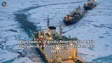
On May 21, 2026, a quiet announcement posted to the National Science Foundation’s (NSF) website sent shockwaves through the global scientific community. With no prior public consultation, no scientific peer review, and no formal notification to Congress, the federal agency declared it was initiating a rapid, systematic "descoping" of the Ocean Observatories Initiative (OOI)—the world's most advanced, multi-hundred-million-dollar deep-ocean monitoring network.
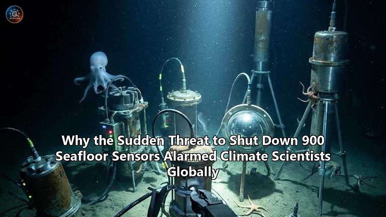
The directive was stark: over the following 15 months, specialized research vessels would span the oceans to physically dredge up and dismantle more than 900 advanced deep-sea sensors, moorings, and vertical profilers from four of the network's five major operating arrays. The affected areas included the Coastal Endurance Array off Oregon and Washington, the Pioneer Array off North Carolina, the Global Station Papa Array in the Gulf of Alaska, and the Global Irminger Sea Array in the subpolar North Atlantic.
The reaction from climate scientists, meteorologists, and marine biologists worldwide was immediate panic. Experts openly described the decision as a self-inflicted scientific catastrophe, warning that it would blind researchers to deep-sea changes at the worst possible moment—just as a potentially record-shattering "Super El Niño" was forming in the Pacific.
The ensuing outrage triggered a fierce, bipartisan congressional intervention. Led by Senators Jeff Merkley (D-OR) and Lisa Murkowski (R-AK), lawmakers passed an emergency measure in late June 2026 to block the NSF from continuing the dismantling and force the redeployment of arrays already touched by the order.
While this sudden legislative intervention has provided a fragile, temporary reprieve, the near-total dismantling of the OOI has exposed a terrifying reality: the critical instruments we rely on to monitor the planet’s vital signs are highly vulnerable to shifting political currents.
The Architecture of the Ocean Observatories Initiative
To understand why the threat of shutting down these systems caused such global alarm, one must first grasp the physical scale and technological sophistication of the Ocean Observatories Initiative.
Commissioned in 2016 after more than a decade of community planning and a $386 million initial investment, the OOI was engineered to transition oceanography from an era of episodic ship-based expeditions to one of continuous, high-resolution, real-time observation. The network was built with a projected 25-to-30-year lifespan, specifically because oceanographers agree that identifying meaningful climate patterns requires at least three decades of uninterrupted, baseline data.
Unlike traditional scientific buoys that only measure atmospheric and surface water conditions, the OOI is a hybrid, multi-layered architecture. It connects the atmosphere, the sea surface, the water column, and the deep ocean floor into a single, integrated data collection system. The network relies heavily on three core technologies:
- Fixed Mooring Arrays: Massive, heavily fortified steel buoys anchored to the seafloor in some of the most hostile marine environments on Earth. These moorings house acoustic modems, power generators, and data transmission systems, acting as communications hubs for undersea instruments.
- Vertical Profilers: Robotic platforms that crawl up and down the mooring cables, continuously measuring temperature, salinity, oxygen levels, pH, and biological productivity from the surface down to the abyssal plains.
- Autonomous Underwater Vehicles and Gliders: Fleets of sleek, battery-powered ocean gliders that navigate between the fixed arrays, mapping the horizontal structure of currents and thermal patterns.
                 [ Satellite / Telemetry Link ]
                              ▲
                             _│_
                            /   \  ◀─── [ Surface Buoy ]
                           │     │      (Wind, Humidity, CO2 Exchange)
                            \___/
                              │
                              │ ◀────── [ Mooring Cable ]
                              │
                      [ Profiler ] ◀─── (Moves up & down, measuring
                              │          Temp, Salinity, pH, Oxygen)
                              │
                              │
                             _│_
                            /   \
                           [     ] ◀─── [ Seafloor Junction Box ]
                            \___/       (Seismic & Hydrothermal Sensors)
                              │
        ============================================= [ Seafloor ]
Crucially, the OOI’s arrays are placed in under-sampled regions subject to extreme conditions where research vessels cannot operate safely year-round.
The Global Irminger Sea Array, situated between Greenland and Iceland, sits in one of the windiest and coldest regions of the global ocean. It is a critical geographic bottleneck where deep-water formation occurs, driving the global ocean circulation system.
The Global Station Papa Array in the Gulf of Alaska monitors the subpolar North Pacific, an area experiencing rapid ocean acidification and shifting ecosystems.
Nearer to the coast, the Endurance Array off the Pacific Northwest and the Pioneer Array off the Mid-Atlantic Bight monitor the shelf-break currents, upwelling zones, and marine heatwaves that directly dictate regional weather and the health of commercial fisheries.
By serving real-time data freely to any internet user in the world, the OOI’s seafloor climate sensors transformed deep-sea oceanography from a closed, privilege-based discipline into a global public utility.
The Ideological Underpinnings of the Shutdown
The sudden push to strip the oceans of these critical diagnostic tools was not an arbitrary administrative shift. It represents the direct implementation of a highly coordinated, ideological policy blueprint.
The dismantling of the OOI aligns closely with policy mandates developed by the Heritage Foundation in its "Mandate for Leadership" document, commonly known as Project 2025. In the document's section targeting the National Oceanic and Atmospheric Administration (NOAA) and the broader federal climate research apparatus, the authors explicitly targeted advanced oceanographic tracking networks. The document claimed that the data produced by initiatives like the OOI was "the source of much of NOAA’s climate alarmism" and advised that the "preponderance of its climate-change research should be disbanded".
┌──────────────────────────────────────────────────────────┐
│             CHRONOLOGY OF THE 2026 OOI CRISIS            │
├──────────────────────────────────────────────────────────┤
│                                                          │
│  Early May 2026:                                         │
│  White House fires the independent board overseeing      │
│  the National Science Foundation (NSF).          │
│                                                          │
│  May 21, 2026:                                           │
│  NSF quietly posts "descoping" order on its website;     │
│  recovery ships prepared to pull 900+ sensors.   │
│                                                          │
│  Early June 2026:                                        │
│  News leaks; global outcry from scientific networks      │
│  and coastal industries.                  │
│                                                          │
│  Mid-June 2026:                                          │
│  Bipartisan coalition of senators introduces emergency   │
│  measure to legally halt the decommissioning.    │
│                                                          │
│  Late June 2026:                                         │
│  NSF capitulates, pauses decommissioning, and plans     │
│  redeployment of the Endurance Array.            │
│                                                          │
└──────────────────────────────────────────────────────────┘
Upon taking office, the administration repeatedly targeted the OOI's $48 million annual operating budget, proposing deep cuts of up to 80 percent in successive budget cycles. While bipartisan majorities in Congress initially successfully restored the funding, the administration shifted tactics to bypass the legislature entirely.
In early May 2026, the White House took the unprecedented step of firing all members of the independent National Science Board, which oversees the NSF. Weeks later, the agency's leadership unilaterally issued the "descoping" order. To justify the action, the NSF deployed highly criticized corporate doublespeak, claiming the destruction of 80 percent of the network aligned with a "nimbler approach to prioritize support for evolving scientific priorities and emerging technologies".
"It is a master class in obfuscation," remarked Tara Blume, an environmental journalist who covered the initial leak of the decommissioning memo. "In a time of strained resources, the agency chose to spend millions of taxpayer dollars to send heavy research vessels to dredge up and render useless the very scientific infrastructure those same taxpayers spent $386 million to build. The goal was not efficiency; it was the deliberate blinding of the public to climate change in the hopes that if we cannot measure it, we can pretend it isn't happening."
Who is Affected? A Multi-Tiered Impact Assessment
The threat to disable the OOI does not merely affect academic researchers in ivory towers. Because ocean dynamics dictate global weather, maritime economics, and national security, the immediate and long-term consequences of losing these seafloor climate sensors cascade through multiple sectors of society.
1. Global Climate Modelers and Meteorologists
Climate forecasting relies on complex mathematical models that simulate the transfer of heat, moisture, and carbon between the atmosphere and the oceans. These models are only as good as the real-world data used to initialize them.
Without continuous deep-sea measurements, models begin to "drift," compounding errors over time. Atmospheric observations alone cannot compensate for a lack of ocean data, which is fundamental to early warning systems for tropical storms, cyclones, and El Niño events.
The loss of these deep-sea inputs would lead to a severe degradation in the accuracy of medium-term weather forecasts, leaving meteorologists unable to reliably predict severe winters in Europe or intense hurricane paths along the U.S. East Coast.
2. The Commercial Fishing Sector
The U.S. commercial fishing industry supports an estimated $319 billion in annual sales and employs 2.1 million people. The health of this industry depends on predictable oceanic conditions.
Along the West Coast, the Coastal Endurance Array tracks seasonal "upwelling"—the process by which deep, cold, nutrient-rich water is pushed toward the surface, fueling the marine food web. However, climate change has increasingly caused these upwelling waters to be severely depleted of oxygen (hypoxia) and highly acidic.
When low-oxygen water upwells onto the continental shelf, it can rapidly suffocate Dungeness crabs, decimate groundfish stocks, and kill millions of farmed oysters.
"Our fishermen rely on real-time OOI data every single day," explained Dr. Jack Barth, an oceanographer at Oregon State University. "It tells them when and where toxic algal blooms are forming, and where hypoxic 'dead zones' are creeping onto the fishing grounds. Pulling these sensors out of the water is like stripping the radar systems out of air traffic control towers. It forces an entire industry to fly blind into economic disaster."
3. Coastal Communities and Municipal Planners
For cities and towns along the Eastern and Western seaboards, long-term sea-level rise and storm surges present existential challenges. Local governments must make multi-million-dollar decisions regarding seawall construction, coastal zoning, and stormwater infrastructure.
These decisions are guided by oceanographic data regarding sea-level trends, wave heights, and coastal erosion patterns. When real-time data streams go dark, the resulting uncertainty forces local governments to either over-engineer defenses at immense cost, or under-prepare and carry catastrophic risks of flooding and property destruction.
4. Sovereign Indigenous Tribes
For decades, Indigenous tribes along the Pacific Northwest coast have used OOI data to monitor, manage, and protect their treaty-guaranteed marine resources.
Tribal marine biologists utilize real-time temperature and pH data to manage salmon hatcheries and wild shellfish harvest areas. The sudden loss of this information would directly undermine tribal sovereignty, treaty rights, and the ecological preservation of ancestral waters.
5. International Scientific Alliances
The ocean is a globally contiguous system; it does not respect national borders. The OOI is a primary American contribution to the Global Ocean Observing System (GOOS), a collaborative international effort to monitor the planetary environment.
By pulling out of its commitments, the United States has severely damaged its standing with international allies.
"The U.S. withdrawal from these monitoring arrays is a profound shock to Canadian research," said Dr. Kate Moran, President of Ocean Networks Canada. "Our monitoring systems off British Columbia are closely aligned with those of the U.S. Pacific Northwest. We share data, coordinate emergency planning, and collaborate on tracking transboundary marine heatwaves. This unilateral retreat leaves a massive, gaping hole in the global scientific safety net."
What Changes? The Science of the "Undersea Blind Spot"
A common argument made by proponents of scientific budget cuts is that expensive ocean-floor installations are obsolete, superseded by modern Earth-observing satellites. This claim, however, displays a fundamental misunderstanding of ocean physics.
Satellites are highly effective at monitoring the "skin" of the ocean—the top millimeter of the sea surface. They can measure surface temperature, sea surface height, and chlorophyll concentrations. However, satellites are entirely blind to what occurs beneath the surface.
[ SATELLITE MONITORING ] ─── (Measures ONLY top 1mm "skin" of ocean)
  │
  ▼
  ░░░░░░░░░░░░░░░░░░░░░░░░░░░░░░░░░░░░░░░░░░░░░░░░░░░░░░░░░░░ [ Sea Surface ]
  ▒▒▒▒▒▒▒▒▒▒▒▒▒▒▒▒▒▒▒▒▒▒▒▒▒▒▒▒▒▒▒▒▒▒▒▒▒▒▒▒▒▒▒▒▒▒▒▒▒▒▒▒▒▒▒▒▒▒▒
  ▒▒▒▒▒▒▒▒▒▒▒▒▒▒▒▒▒▒▒▒▒▒▒▒▒▒▒▒▒▒▒▒▒▒▒▒▒▒▒▒▒▒▒▒▒▒▒▒▒▒▒▒▒▒▒▒▒▒▒
  ▒▒▒▒▒▒▒▒▒▒▒▒▒▒▒▒▒▒▒▒▒▒▒▒▒▒▒▒▒▒▒▒▒▒▒▒▒▒▒▒▒▒▒▒▒▒▒▒▒▒▒▒▒▒▒▒▒▒▒ ◀─── [ SATELLITE
  ▒▒▒▒▒▒▒▒▒▒▒▒▒▒▒▒▒▒▒▒▒▒▒▒▒▒▒▒▒▒▒▒▒▒▒▒▒▒▒▒▒▒▒▒▒▒▒▒▒▒▒▒▒▒▒▒▒▒▒      BLIND SPOT ]
  ▒▒▒▒▒▒▒▒▒▒▒▒▒▒▒▒▒▒▒▒▒▒▒▒▒▒▒▒▒▒▒▒▒▒▒▒▒▒▒▒▒▒▒▒▒▒▒▒▒▒▒▒▒▒▒▒▒▒▒
  ▒▒▒▒▒▒▒▒▒▒▒▒▒▒▒▒▒▒▒▒▒▒▒▒▒▒▒▒▒▒▒▒▒▒▒▒▒▒▒▒▒▒▒▒▒▒▒▒▒▒▒▒▒▒▒▒▒▒▒
  │
  ▼
[ SEAFLOOR CLIMATE SENSORS ] ─── (Continuously monitor deep currents, pH,
                                  oxygen, and heat storage down to 3,000m)
The ocean is three-dimensional, and more than 90 percent of the excess heat trapped on Earth by greenhouse gas emissions is absorbed by the deep ocean—not the surface. To monitor where that heat is moving, how it is circulating, and how it is altering the chemistry of the deep, physical instruments must be placed in the water.
"Without the vertical profiles and the bottom-dwelling sensors, you are essentially trying to diagnose a patient’s internal cardiovascular health by looking only at their skin temperature," said Sabrina Speich, an expert in global ocean monitoring at the École Normale Supérieure (ENS) in Paris. "You will miss the internal hemorrhaging entirely."
Beyond the loss of depth profiling, the physical removal of these seafloor climate sensors introduces a devastating mathematical problem: the destruction of continuous time-series data.
In climate science, the power of data is cumulative. To prove that an environmental change is part of a long-term anthropogenically driven trend, rather than a natural, short-term fluctuation, scientists require an unbroken chain of observations over decades.
If you interrupt a 10-year record for even a single year, you create a gap that can never be reconstructed. If you attempt to restart the monitoring program years later, you have to reset the baseline, losing the cumulative statistical power of the previous decade’s work.
By pulling these arrays out of the water, the NSF did not just save a fraction of its budget; it actively destroyed the scientific integrity of the decade of research that came before it.
Short-Term Perils: Steering Blindly into the 2026-2027 Super El Niño
While the long-term scientific degradation is severe, the immediate, short-term consequences of the OOI shutdown are terrifyingly concrete.
As the NSF’s recovery vessels prepared to pull the first buoys out of the Pacific in June 2026, meteorologists were already sounding the alarm over a looming "Super El Niño". Characterized by an immense buildup of exceptionally warm water in the equatorial Pacific, El Niño is a dominant driver of global weather patterns. The incoming event was projected by international modeling centers to be potentially record-breaking, bringing intense storm systems, disrupted agricultural rainfall, and severe droughts across South America, Asia, and Africa.
During an El Niño, ocean heat does not simply stay at the surface; it moves in massive, subsurface waves known as Kelvin waves, which travel eastward across the Pacific and then surge northward along the coast of North America. This warm, subsurface water can completely suppress the normal, cold-water upwelling systems off California, Oregon, and Washington, triggering intense, localized marine heatwaves.
       [ NORMAL CONDITIONS ]                   [ EL NIÑO CONDITIONS ]

   West                       East         West                       East
  ┌──────┐                 ┌──────┐       ┌──────┐                 ┌──────┐
  │ Asia │                 │Ameri.│       │ Asia │                 │Ameri.│
  └──────┘                 └──────┘       └──────┘                 └──────┘
     ◀─── Strong Trade Winds ───             ─── Weak/Reversed Winds ───▶

   Warm Water   │   Cold Water             Cold Water   │   Warm Water
  (West Pacific)│ (East Pacific)          (West Pacific)│ (East Pacific)
  ~~~~~~~~~~~~~~└───~~~~~~~~~~~~          ~~~~~~~~~~~~~~└───~~~~~~~~~~~~
                ▲                                           ▲
         Normal Upwelling                            Upwelling Blocked
        (Nutrient-Rich, Cold)                        (Subsurface Heat Wave)
The Coastal Endurance Array and the Global Station Papa Array were designed to detect these subsurface heat shifts weeks before they reached the surface, providing critical warnings to coastal communities and commercial fisheries.
Removing these Pacific arrays at this exact juncture meant that scientists would lose their ability to track the depth and velocity of this incoming ocean heat.
"This is quite literally the worst possible time to be pulling out the instruments," warned Dr. Jack Barth. "An El Niño of this scale is a massive, planetary-scale event. By disabling the OOI arrays, we are essentially turning off our early warning radar just as the storm of the decade is crossing our borders."
The consequences of this blind spot would have immediately compromised:
- Atmospheric Weather Forecasts: The heat released by these marine heatwaves alters the path of the jet stream, directly dictating whether the western United States experiences extreme, atmospheric-river storm events or severe winter droughts. Without subsurface data, the predictive accuracy of these meteorological models would have degraded, leaving municipal emergency management agencies with less time to prepare for catastrophic winter flooding.
- Fisheries Management: Marine heatwaves can cause rapid, unpredictable shifts in the distribution of toxic pseudo-nitzschia algae, which produce domoic acid—a neurotoxin that accumulates in shellfish and can cause permanent brain damage or death in humans. Without real-time tracking of water temperature and salinity profiles, state health departments would have to choose between keeping entire fisheries closed indefinitely out of caution, or risk public health by allowing harvests to proceed unmonitored.
- Emergency Coastal Evacuation Planning: Unprecedented subsurface thermal expansion can trigger sudden, localized increases in coastal sea levels, exacerbating tidal flooding and coastal erosion. Without cabled seafloor monitoring, coastal planners would have had no way to differentiate between normal tidal variances and severe, heat-induced coastal ocean surges.
Long-Term Catastrophes: AMOC, Carbon Saturation, and the 163% Error Margin
While the immediate loss of Pacific monitoring threatens to disrupt regional weather and fisheries, the long-term, global consequences of the OOI dismantling are far more ominous.
The Slow-Motion Collapse of the AMOC
The most scientifically alarming aspect of the NSF's descoping order was the planned destruction of the Global Irminger Sea Array. Located south of Greenland, this array sits in one of the most critical geographic regions for the regulation of the Earth's climate.
The Irminger Sea is a primary engine of the Atlantic Meridional Overturning Circulation (AMOC)—the colossal ocean conveyor belt that transports warm, tropical water northward from the equator to the North Atlantic, while sending cold, deep water southward toward the Southern Ocean. This circulation plays an indispensable role in maintaining the temperate climate of Europe and regulating tropical rainfall belts.
                     [ ATLANTIC OCEAN CONVEYOR BELT (AMOC) ]

         Warm, Salty Surface Current (Gulf Stream) ──▶  [ Irminger Sea ]
                                                          (Sinking Zone)
                                                          │
          Abyssal Southward Flow (Cold, Deep Water) ◀─────┘
As greenhouse gas emissions trap heat in the atmosphere, melting glaciers in Greenland and Arctic sea ice are pouring massive quantities of fresh, cold water into the subpolar North Atlantic. Fresh water is less dense than salty water; as a result, it resists sinking, effectively clogging the AMOC engine.
In recent years, physical oceanographers have detected alarming signals that the AMOC is weakening at an accelerating rate—and may be approaching a catastrophic tipping point. If the AMOC were to collapse, it would trigger a sudden, irreversible rewriting of the global climate:
- Temperatures in Northern Europe would plunge by up to 10 to 15 degrees Celsius, creating winters far more severe than any experienced in modern history.
- The East Coast of the United States would experience a rapid, devastating sea-level rise of up to a meter, completely submerging major portions of coastal cities.
- Monsoon rains that feed hundreds of millions of people in Africa, Asia, and South America would shift, triggering widespread agricultural collapse and unprecedented global humanitarian crises.
Fixed 2,800 meters below the surface, the OOI's Irminger Sea seafloor climate sensors are among the few instruments on Earth capable of measuring the deep-water velocities, densities, and salinity changes that tell us exactly how close the AMOC is to collapse.
"To pull these sensors out of the water now is absolute madness," said David Doniger, a senior climate strategist. "We are actively messing with the thermodynamic knobs of our planet, and the administration’s response is to turn off the temperature gauges. It is the equivalent of a passenger on a malfunctioning airplane smashing the altimeter so they don't have to watch the plane descend."
┌────────────────────────────────────────────────────────┐
│             ESTIMATED ANNUAL CLIMATE COSTS             │
├────────────────────────────────────────────────────────┤
│                                                        │
│  US Weather/Climate Disaster Damages (2024):           │
│  ███████████████████████████████████████ $177 Billion  │
│                                                │
│                                                        │
│  Entire US Ocean Observatories Initiative Budget:     │
│  ░ $0.048 Billion                                      │
│                                                │
│                                                        │
└────────────────────────────────────────────────────────┘
The 163% Error Margin: Compounding Global Uncertainty
The scientific cost of removing these arrays is not a theoretical abstraction; it has been rigorously quantified.
In a peer-reviewed study led by Sabrina Speich and a team of international oceanographers, researchers calculated the statistical consequences of removing the OOI arrays from the global observation network. The findings were staggering: removing U.S. deep-ocean observations alone would produce a 163 percent increase in error in annual estimates of the world’s ocean heating rates.
"A 163 percent increase in error means we essentially lose our ability to calculate the global heat budget," explained Speich. "We would not be able to tell with any scientific accuracy how fast the oceans are warming, where that heat is being stored, or when it will be released back into the atmosphere. This error compounds through every climate model on Earth, rendering our long-term predictions of sea-level rise, storm intensity, and agricultural disruption dangerously unreliable."
Furthermore, the deep ocean is one of the planet's primary carbon sinks, absorbing roughly 25 to 30 percent of human-emitted carbon dioxide.
The Global Station Papa and Irminger Sea arrays monitor this critical "carbon pump," measuring how seawater chemistry changes as it absorbs carbon dioxide, and tracking when the deep ocean might reach a saturation point.
If the deep ocean's capacity to absorb carbon saturates, atmospheric warming will accelerate at a rate far outstripping current predictions. By disabling these monitoring networks, we are effectively disabling our ability to see when this planetary safety valve is about to fail.
The Economic Math of Scientific Ignorance
The decision to shut down the OOI was framed by proponents as a cost-saving measure. The network costs approximately $48 million annually to operate and maintain.
However, when compared to the economic toll of unforecasted and unmitigated weather disasters, this "saving" represents an extraordinary act of financial self-sabotage.
According to data compiled by NOAA, between 1980 and 2024, the United States suffered more than 400 weather and climate disasters where total damages exceeded or reached $1 billion. In 2024 alone, the total cost of these disasters in the U.S. amounted to $177 billion.
"The U.S. government wanted to save less than $50 million a year by turning off the eyes and ears of the ocean," said Dr. John Abraham, a thermal physics expert. "But we are carrying hundreds of billions in climate costs every year. The cost of maintaining the entire OOI network for an entire decade is a tiny fraction of the cost of a single major unforecasted hurricane hitting the Gulf Coast or the eastern seaboard. Investing in deep-sea observations is not a luxury; it is basic risk management."
┌────────────────────────────────────────────────────────────────────────┐
│               THE RIPPLE EFFECT OF THE OOI SYSTEM DEGRADATION          │
├────────────────────────────────────────────────────────────────────────┤
│                                                                        │
│  [LOSS OF CONTINUOUS SEAFLOOR SENSORS]                                 │
│          │                                                             │
│          ├─▶ 163% Increase in Ocean Heating Rate Calculation Error     │
│          │   (Speich et al., 2026)                             │
│          │                                                             │
│          ├─▶ Drastic reduction in early warning lead time for major    │
│          │   hurricanes, Nor'easters, and storm surges         │
│          │                                                             │
│          ├─▶ Inability to monitor deep ocean currents (AMOC)           │
│          │   responsible for European and East Coast climate   │
│          │                                                             │
│          └─▶ Loss of real-time hypoxia & acidification alerts          │
│              for the $319B US commercial fishing industry│
│                                                                        │
└────────────────────────────────────────────────────────────────────────┘
A Fragile Reprieve: What Comes Next?
The sudden threat to shut down the OOI has created a profound crisis, but it also catalyzed an unprecedented, furious political backlash that has rewritten the immediate future of the network.
In mid-June 2026, as the first recovery vessels began pulling instruments from the water, a bipartisan coalition of U.S. senators stepped forward to challenge the NSF’s unilateral decision. The effort was spearheaded by Senator Jeff Merkley, whose home state of Oregon relies heavily on OOI data to manage its sustainable coastal fisheries, and Senator Lisa Murkowski of Alaska, where coastal communities face immediate threats from rising subpolar ocean temperatures and changing marine ecosystems.
The senators, along with environmental non-profits and representatives from the commercial fishing sector, argued that the NSF’s actions were not only scientifically disastrous but also legally unauthorized. They pointed out that Congress had repeatedly rejected the administration’s proposed budget cuts and restored full funding to the OOI. By unilaterally descoping 80 percent of the project without consulting Congress, the NSF was arguably violating federal appropriations law.
In late June 2026, the coalition successfully attached a legislative amendment to an emergency spending bill, legally stripping the NSF of the authority to spend any funds on the decommissioning of the OOI. Crucially, the measure went further, legally mandating that the NSF halt all dismantling activities and immediately plan for the redeployment of any hardware that had already been removed.
Faced with this legal and financial checkmate, the NSF capitulated. On June 23, 2026, the agency issued an updated statement confirming that it would "pause" further removal or descoping of the OOI infrastructure and begin active planning to redeploy the Endurance Array off the Pacific Northwest.
"The attempt to dismantle the OOI was supreme stupidity," Senator Jeff Merkley declared following the legislative victory. "We have successfully put the brakes on this reckless plan, and we will keep fighting to ensure that our scientists, our fishermen, and our coastal communities can continue to utilize the critical data this network provides."
Lessons from the Brink: Designing Climate Science for the Future
While the scientific community has celebrated this dramatic, last-minute rescue, the near-death experience of the OOI has permanently altered the way oceanographers view their discipline. The crisis has revealed that even the most advanced, globally critical scientific infrastructure is highly vulnerable to political whim when it relies entirely on a single nation’s budget cycle.
"We got lucky this time," said Dr. Kate Moran of Ocean Networks Canada. "But we cannot run global climate monitoring on luck. The ocean does not stop changing because a government decides to stop watching. We must ask ourselves hard questions about how we design, fund, and govern these vital systems going forward."
Oceanographers and international policymakers are now discussing several major structural shifts to insulate global climate monitoring from domestic political volatility:
1. Internationalizing Ocean Data Infrastructure
Currently, the OOI is heavily dependent on funding from a single source: the U.S. National Science Foundation.
To prevent future single-point failures, there is a growing push to transition these networks to international consortia. This model would distribute the operational costs and management across multiple nations, similar to how the European Space Agency or the European Southern Observatory are run.
Under an international governance structure, a single nation could not unilaterally decide to pull the plug on arrays like the Irminger Sea, which impacts the climate safety of dozens of countries.
2. Diversifying Funding via Sovereign and Private Partnerships
To build long-term financial resilience, future ocean observing systems may need to move beyond complete reliance on government grants.
By creating public-private partnerships that include philanthropic organizations, commercial maritime industries, and insurance and reinsurance giants—who have a massive financial interest in accurate climate forecasting—ocean observing networks can establish independent endowment funds that are immune to federal budget battles.
3. Decentralized and Interoperable Observing Networks
Technological advances are allowing for more distributed, less centralized ocean tracking. While massive, multi-million-dollar moorings are indispensable, they can be supplemented by larger fleets of smaller, cheaper, autonomous instruments operated by a wider array of global institutions.
By standardizing data protocols and ensuring complete interoperability between different national systems—such as the U.S. OOI, the European Union's OceanEye initiative, and Ocean Networks Canada—the global community can build a decentralized monitoring web that is far harder to dismantle with a single political decision.
               [ FUTURE OF OCEAN MONITORING ]

                   ┌───────────────────────┐
                   │ Global Union Consortia│
                   └───────────┬───────────┘
                               │
         ┌─────────────────────┼─────────────────────┐
         ▼                     ▼                     ▼
┌────────────────┐     ┌───────────────┐     ┌───────────────┐
│ U.S. (NSF/OOI) │     │European Union │     │ Canada (ONC)  │
│  Funding Node  │     │ (OceanEye)    │     │ Funding Node  │
└────────┬───────┘     └───────┬───────┘     └───────┬───────┘
         │                     │                     │
         └─────────────────────┼─────────────────────┘
                               ▼
            ┌─────────────────────────────────────┐
            │ DECENTRALIZED SEAFLOOR OBSERVATION  │
            │  * Hardened to political shifts     │
            │  * Shared maintenance costs         │
            │  * Globally distributed data nodes  │
            └─────────────────────────────────────┘
The lesson of the 2026 OOI crisis is clear: our understanding of the planet is only as strong as the physical observations that feed our models.
The sudden, near-destruction of the OOI was a stark reminder that in an era of rapid planetary change, the scientific systems we use to monitor our environment are not permanent, self-sustaining fixtures. They are fragile human creations that must be actively defended.
The oceans are warming, the deep currents are slowing, and the climate is shifting on a planetary scale. The June 2026 pause has kept our eyes open for now—but the scientific community has been warned: if we lose our capacity to watch the deep ocean, we will be forced to live through the consequences of our ignorance in the dark.
Reference:
- https://oceanobservatories.org/2026/05/nsf-ooi-descoping-update-for-the-community/
- https://projectgeospatial.org/geospatial-frontiers/the-silencing-of-the-deep-the-geospatial-tragedy-of-dismantling-the-ocean-observatories-initiative
- https://financialpost.com/pmn/business-pmn/trump-scraps-ocean-sensors-providing-crucial-data-on-climate-flooding-2
- https://www.theguardian.com/us-news/2026/jun/16/ocean-monitoring-cuts-trump
- https://www.earth.com/news/trump-administration-shuts-down-major-ocean-monitoring-network/
- https://oceanographicmagazine.com/news/trump-administration-dismantles-critical-ocean-floor-observation-network/
- https://www.youtube.com/watch?v=yTpETcRkwqI
- https://news.mongabay.com/short-article/2026/06/scientists-warn-of-climate-blind-spot-as-u-s-dismantles-ocean-sensors/
- https://www.govexec.com/management/2026/06/one-federal-research-network-got-reprieve-others-may-not/414499/?oref=ge-featured-river-top
- https://www.eeldrone.com/insights/when-the-ocean-goes-dark-what-the-ocean-observatories-initiative-descoping-means-beyond-climate-science
- https://www.fox13news.com/news/ocean-observatories-initiative-dismantled-trump-administration-what-know
- https://en.wikipedia.org/wiki/Ocean_Observatories_Initiative
- https://oceanobservatories.org/about-ooi/
- https://www.youtube.com/watch?v=q3pwxZ3kgwc
- https://www.opb.org/article/2026/06/03/oregon-washington-scientists-lose-critical-climate-record-ocean-observatory-trump-cuts/
- https://www.theguardian.com/environment/2026/jun/02/trump-administration-ocean-observatories-initiative
- https://www.theinvadingsea.com/2026/06/06/ocean-observatories-initiative-trump-climate-change-temperatures-nsf-currents-amoc/
- https://democrats-science.house.gov/download/2026-06-15-sst-hnr-letter-to-nsf-on-ooi
- https://ooifb.org/news/nsf-update-on-the-ocean-observatories-initiative/
- https://www.theguardian.com/environment/2026/jun/05/trump-plan-ocean-monitoring-system-concern-scientists
- https://www.timescolonist.com/local-news/us-pulling-ocean-sensors-a-shock-for-canadian-research-as-el-nino-nears-12422874
- https://oceanographicmagazine.com/news/trump-administration-dismantles-critical-ocean-floor-observation-network/
- https://oceanobservatories.org/