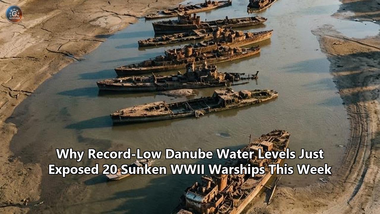
A punishing summer heatwave and prolonged regional drought have driven the Danube River down to some of its lowest discharge levels in nearly a century, laying bare a menacing obstacle course of naval history. Along a five-kilometer stretch of the river near the Serbian port town of Prahovo, on the border with Romania, receding waters have exposed the rusted superstructures, gun mounts, and mangled hulls of at least 20 German warships scuttled during the closing stages of World War II.
The sudden emergence of these vessels has transformed a historical curiosity into an urgent navigational and security crisis. With river depth dropping precipitously across Central and Southeastern Europe, the presence of the sunken WWII ships Danube corridor has throttled the river’s navigable fairway from a standard 180 meters down to barely 90 meters. Commercial freight barges, cargo convoys, and river cruise liners are now forced to wait up to four hours for single-file clearance through the bottleneck, halving their payloads to clear the shallow riverbed and inflicting severe financial penalties on Europe’s internal supply chain.
                DANUBE RIVER PROFILE AT PRAHOVO BOTTLENECK
  ========================================================================
  Normal Conditions:
  [======================== 180-Meter Navigable Fairway ========================]
  Depth: Adequate for two-way barge convoys running full draft (2.5m - 3.0m)
  ------------------------------------------------------------------------
  Drought & Low Water Levels (Current Situation):
  [=== 90m Restricted Fairway ===] | [XX Sunken Warships & Sandbars XX]
  Depth: Heavily reduced; single-file transit only; 50% cargo limits enforced
  ========================================================================
The crisis has brought opposing engineering philosophies, risk assessments, and environmental priorities into sharp relief. Facing a submerged graveyard of up to 200 vessels packed with an estimated 10,000 unexploded munitions, European and Serbian authorities are wrestling with whether to extract the wrecks completely, entomb them deeper beneath the river bottom, or rely on aggressive dredging bypasses. Each approach carries vastly different tradeoffs across cost, navigation efficiency, unexploded ordnance safety, and riverine ecosystem preservation.
The Historical Origin: Operation Danube Elf and the Prahovo Barrier
The wrecks exposed by the drought represent the remnants of Kampfgruppe Zieb, a naval combat and transport group commanded by Kriegsmarine Rear Admiral Paul-Willy Zieb. In August 1944, as Soviet forces shattered German positions in Bessarabia and Romania suddenly switched allegiances to join the Allies, hundreds of German naval vessels, support craft, and military personnel found themselves cut off in the Black Sea and lower Danube.
Rear Admiral Zieb organized a chaotic upstream evacuation under the operational umbrella known as Unternehmen Donauelfe (Operation Danube Elf). His flotilla eventually swelled to roughly 200 craft:
- Artillery-carrier barges equipped with 88mm anti-aircraft guns
- Marine landing craft (Marinefährprähme or MFPs)
- Siebel transport ferries
- Coastal defense patrol boats (Kriegsfischkutter)
- Tugboats, workshop barges, and the hospital ship Bamberg
- Over 4,000 soldiers, wounded personnel, and civilians
                     KAMPFGRUPPE ZIEB RETREAT ROUTE (1944)

   Black Sea / Lower Danube Ports (Galați / Brăila)
                    │
                    ▼  (Upstream advance under heavy Soviet artillery fire)
   Calafat / Cernavodă Gorges
                    │
                    ▼  (Soviet forces capture Iron Gates ahead of convoy)
   Prahovo Gorge Barrier (Djerdap II)
                    │
                    ▼  [CONVOY TRAPPED]
   Strategic Scuttling Order: 200+ vessels sunk in zigzag tactical formation
Upon reaching Prahovo, just downstream from the formidable Iron Gates gorge (Djerdap), Zieb discovered that Soviet troops and Romanian forces had already secured the narrow upstream defiles. Unable to force passage through the rapids with heavy, deep-draft vessels in low late-summer waters, Zieb executed a scorched-earth denial strategy. On September 2–7, 1944, German crews scuttled their entire armada in systematic, overlapping zigzag formations across the main navigational channel. The objective was explicit: deny the Soviet Red Army and its river flotillas access to Central Europe by physically walling off the waterway.
While the Soviet army bypassed the obstacle over land, the sunken armada remained. Following the war, Yugoslav authorities managed to refloat and scrap or recondition a handful of accessible vessels. The remainder—strewn across the riverbed, covered in shifting silt, and packed with volatile artillery shells, naval mines, and depth charges—were abandoned as too hazardous and technically difficult to remove.
Mechanical Extraction vs. In-Situ Sub-Aquatic Burial
The re-emergence of more than 20 distinct hulls this month has renewed scrutiny on the €29.1 million clearance project financed jointly by the Serbian government, the European Investment Bank (EIB), and European Union grants under the Western Balkans Investment Framework (WBIF). The initiative aims to clear 21 of the most hazardous wrecks that directly compromise international maritime transit. However, contractors and marine engineers face a fundamental operational dilemma: should they execute full mechanical extraction or resort to in-situ sub-aquatic burial?
                         COMPARING REMOVAL PATHWAYS

   ┌───────────────────────────────────┐    ┌───────────────────────────────────┐
   │    FULL MECHANICAL EXTRACTION     │    │   IN-SITU SUB-AQUATIC BURIAL      │
   ├───────────────────────────────────┤    ├───────────────────────────────────┤
   │ 1. Silt clearance via air-lifts   │    │ 1. Hydro-suction perimeter trench │
   │ 2. Manual EOD bomb neutralization │    │ 2. Vessel settles below draft line│
   │ 3. Heavy floating-crane hoisting  │    │ 3. Natural sediment entombment    │
   │ 4. Yard deconstruction & recycling│    │ 4. Ordnance remains undisturbed   │
   ├───────────────────────────────────┤    ├───────────────────────────────────┤
   │ PROS: Permanent navigational fix  │    │ PROS: 60% lower cost; minimal     │
   │ CONS: High atmospheric blast risk │    │       blast risk during low water │
   │       and massive disposal costs  │    │ CONS: Ordnance stays in riverbed; │
   │                                   │    │       future erosion can expose it│
   └───────────────────────────────────┘    └───────────────────────────────────┘
Full Mechanical Extraction: The High-Cost, High-Risk Absolute Solution
Mechanical extraction entails deploying heavy-duty salvage barges equipped with sheerleg crane pontoons, high-capacity winches, and sediment air-lifts. Marine salvagers systematically clear tons of compacted mud from around the hull, send explosive ordnance disposal (EOD) divers inside to neutralize or extract loose munitions, and rig heavy wire strops beneath the keel. The vessel is then winched to the surface, drained of river water, stabilized on a transport pontoon, and towed downstream for land-based deconstruction and recycling.
This method provides an absolute navigational remedy. By removing the steel structures entirely, the riverbed is permanently restored to its natural depth, expanding the fairway to its full 200-meter capacity and eliminating the need for recurring draft restrictions.
The drawbacks of full extraction, however, are severe:
- Atmospheric Oxidation and Detonation: Naval ammunition that has remained submerged in an anaerobic, low-oxygen underwater environment for over 80 years can undergo rapid chemical degradation when suddenly exposed to ambient air and oxygen. Picric acid compounds, deteriorating nitrocellulose, and unstable primer caps can become shock-sensitive, creating extreme explosion risks for salvage crews working on open pontoons.
- Structural Disintegration: Many of the hulls have suffered heavy corrosion. Under the concentrated tension of heavy crane slings, weakened iron plates and frames can snap, dropping sections of the ship back to the riverbed and dispersing corroded ammunition across a wider perimeter.
- Capital Intensity and Slow Pacing: The removal of a single vessel can require several months of painstaking EOD prep work and weather-dependent diving conditions.
In-Situ Sub-Aquatic Burial: The Pragmatic Stabilization Alternative
In contrast, in-situ sub-aquatic burial avoids lifting the dangerous hulls above the waterline. Using industrial hydro-suction pumps and cutter dredgers at a safe standoff distance, salvage engineers excavate deep trenches directly adjacent to and underneath the sunken hulls. As the sediment support is liquefied and drawn away, the weight of the warship causes it to settle several meters deeper into the riverbed, sinking below the Danube’s minimum required navigational clearance draft (typically 2.5 to 3.5 meters below the lowest reference water level).
"Depending on the vessel's condition, some may not be salvageable due to their size and poor state," explained Aleksandar Banjac, Serbia's assistant minister of construction, transport and infrastructure. "Options include underwater cutting or excavation. Currently, two ships are being buried into the river bottom."
The advantages of this approach include:
- Safety Preservation: Munitions remain underwater in a chemically stable, anaerobic thermal environment, eliminating the blast hazard associated with hoisting live bombs into the atmosphere.
- Speed and Economy: Burial operations can be executed in a fraction of the time required for complete extraction, costing roughly 40% to 60% less per vessel and allowing rapid fairway widening during brief low-water windows.
Yet, burial is an incomplete compromise. Hydrological shifts, major flash floods, or shifting gravel banks can gradually scour away the overburden, re-exposing the jagged hulls and explosive ordnance decades later. Furthermore, it leaves thousands of kilograms of toxic heavy metals, degraded picric salts, and munitions permanently entombed inside an active freshwater corridor.
Technical Remediation Matrix
To understand how regional authorities navigate these conflicting options, the table below contrasts the four primary methods currently evaluated or deployed along the Prahovo corridor:
| Remediation Methodology | Capital Cost per Vessel | UXO Safety Risk Profile | Navigational Efficacy | Ecological Impact Score | Execution Speed per Unit |
|---|---|---|---|---|---|
| Full Mechanical Crane Extraction | €1.2M – €2.2M | Very High: Air exposure can trigger unstable detonators and aged TNT. | Permanent: Restores 100% channel clearance to 200m width. | Moderate: Localized sediment plume; removes toxic metal source. | 45–90 days |
| In-Situ Hydro-Suction Burial | €400K – €750K | Low: Munitions remain submerged and undisturbed in anaerobic mud. | Moderate: Clears immediate draft, but vulnerable to future bed scour. | High: Heavy riverbed turbidity; leaves ordnance in water basin. | 10–20 days |
| Dynamic Navigational Bypass Dredging | €250K – €500K/yr | Extreme: Cutter heads risk striking undetected ordnance near wrecks. | Temporary: Requires recurring seasonal dredging to maintain bypasses. | Very High: Destroys benthic habitat; risks catastrophic underwater blasts. | Ongoing / Seasonal |
| Controlled In-Situ Demolition (Historical/Defunct) | €150K – €300K | Critical: High chance of sympathetic detonation of adjacent wrecks. | Poor: Shatters steel into jagged underwater debris fields. | Catastrophic: Lethal acoustic shockwaves to aquatic life; chemical dispersal. | 3–5 days |
Detection and Identification: Advanced Bathymetry vs. Manual Tactile Diving
A major hurdle in addressing the sunken WWII ships Danube crisis lies in accurately assessing what sits below the waterline. The murky, sediment-dense waters of the lower Danube create near-zero optical visibility, requiring engineers to compare and integrate modern non-invasive hydrographic imaging with high-risk manual diver reconnaissance.
┌────────────────────────────────────────────────────────────────────────────┐
│                    REMOTE SENSING VS. TACTILE DIVERS                       │
├─────────────────────────────────────┬──────────────────────────────────────┤
│ Non-Invasive Hydrographic Imaging   │ Manual EOD Diver Reconnaissance      │
├─────────────────────────────────────┼──────────────────────────────────────┤
│ • High-frequency multibeam sonar    │ • Zero-visibility tactile feeling    │
│ • Side-scan acoustic backscatter    │ • Direct contact with corroded fuses │
│ • Marine proton-precession magnetos │ • Verification of metal integrity    │
│ • Rapid, whole-channel 3D models    │ • Exhaustive, dangerous inspection   │
├─────────────────────────────────────┴──────────────────────────────────────┤
│ SYNTHESIS: Remote sonar identifies coordinates and gross hull morphology;  │
│ divers must verify explosive stability before any winch cable is tensioned.│
└────────────────────────────────────────────────────────────────────────────┘
Non-Invasive Hydrographic Imaging
Before deploying personnel into the river, hydrographic survey teams rely on a suite of remote sensing technologies to map the riverbed:
- Multibeam Echo-Sounders (MBES): Emitting fan-shaped acoustic swaths across the riverbed, MBES systems generate high-density 3D bathymetric point clouds. These models reveal the spatial orientation of the hulls, their degree of silt burial, and the precise navigational draft remaining above the highest structural protrusions.
- Side-Scan Sonar (SSS): By measuring acoustic backscatter intensity, SSS generates photographic-quality acoustic maps of the riverbed topography, highlighting structural fractures, detached gun barrels, and scattered debris fields.
- Marine Magnetometers and Gradiometers: Marine proton-precession magnetometers measure localized distortions in the Earth’s magnetic field caused by ferrous mass. This allows surveyors to differentiate between non-metallic riverbed mounds and buried steel hulls, while also detecting large clusters of iron-cased artillery shells hidden beneath layers of silt.
While remote sensing provides rapid, comprehensive data across kilometers of waterway, it cannot evaluate chemical stability, rivet fatigue, or the trigger sensitivity of corroded mechanical fuses.
High-Risk Tactile Diving Operations
Because remote sensors cannot peer inside sealed, silt-filled holds, certified EOD divers must physically enter the dynamic current of the Danube to conduct tactile inspections.
Working in near-total darkness where visual range is often less than 20 centimeters, divers must navigate jagged, rust-pitted steel plates using touch alone. They search for sensitive impact fuzes, determine whether chemical stabilizers in naval artillery rounds have leached out, and identify the structural points strong enough to support lifting straps.
This direct human intervention involves extreme risks:
- Divers face high river currents that can pin them against sharp wreckage or destabilize unexploded munitions.
- Sediment collapses inside flooded compartments can trap divers beneath the mud line.
- Tensioned cables during trial rigging can slip on corroded hulls, risking mechanical failure or kinetic impacts on sensitive explosive payloads.
Ultimately, neither technology functions as a standalone solution. Acoustic mapping directs divers to exact coordinates, while manual tactile verification provides the definitive safety clearance required before any heavy lifting machinery can be engaged.
Economic Logistics vs. Ecological Preservation
The dilemma surrounding the exposed wrecks extends beyond salvage engineering; it exposes a structural conflict between European industrial transport priorities and fragile river ecology.
        ECONOMIC IMPERATIVES             ECOLOGICAL SAFEGUARDS
   ┌──────────────────────────────┐ ┌──────────────────────────────┐
   │ • TEN-T Rhine-Danube Channel │ │ • Toxic Munition Leaching    │
   │ • €5M+ Annual Freight Losses │ │ • Sturgeon Spawning Grounds  │
   │ • 50% Agricultural Cutbacks  │ │ • Hypoxic High-Heat Waters   │
   │ • Energy Sector Coal Supply  │ │ • Municipal Drinking Basins  │
   └──────────────┬───────────────┘ └──────────────┬───────────────┘
                  │                                │
                  └────────► [POLICY DEADLOCK] ◄───┘
The Economic Mandate: Unlocking a Core Continental Arterial Corridor
The Danube is the backbone of the European Union’s Trans-European Transport Network (TEN-T) Rhine-Danube Core Network Corridor, which links the Black Sea to Central Europe and the industrial ports of the North Sea. Inland waterway transport is an exceptionally carbon-efficient mode of long-distance cargo transit: a single standard four-barge push-tow convoy can move up to 7,000 metric tons of cargo, replacing roughly 350 heavy freight trucks on regional road networks.
When droughts drop water levels, the presence of scuttled WWII vessels turns the Prahovo corridor into an insurmountable economic barrier:
- Capacity Reductions: Commercial carriers operating along the Romanian-Serbian border are forced to reduce their cargo loads by 30% to 50% to decrease their vessel draft, doubling shipping costs per ton and stranding vital grain, fertilizer, and coal shipments.
- Congestion and Operating Losses: The Serbian Ministry of Construction, Transport and Infrastructure calculates direct annual economic losses exceeding €5 million due to transit delays, localized towage surcharges, and bottleneck wait times alone.
- Energy Sector Disruptions: Coal barges feeding thermal power installations along the middle Danube face delivery delays, coinciding with high electricity demand caused by heatwaves.
"Now is the right time, as river traffic and goods transport on the Danube are increasing significantly," noted Assistant Minister Aleksandar Banjac during a project briefing. "The river is a crucial artery for Europe, and this particular section is of great interest to shippers."
The Ecological Dilemma: Disturbed Toxins in a Sick River
While the economic lobby demands rapid clearance and deeper dredged channels, river ecologists warn that disruptive interventions could compound the damage to an already fragile ecosystem.
The Danube in late summer suffers from elevated water temperatures (often reaching 28°C in Serbian reaches) and reduced flow volume, which severely depresses dissolved oxygen levels and encourages bacterial growth.
                               ECOLOGICAL RISK CASCADE

  Corroded Munitions / Fuel Tanks
         │
         ▼ (Aggressive Dredging / Slag Agitation)
  Heavy Metal & Picric Acid Release ──► Leaching into Municipal Water Basins
         │
         ▼ (High Water Temperatures: ~28°C)
  Depressed Dissolved Oxygen Levels ──► Phytoplankton Blooms & Fish Kills
         │
         ▼ (Physical Habitat Disruption)
  Destruction of Iron Gates Gravel Beds ──► Disruption of Endangered Beluga Sturgeon
Environmental specialists emphasize several compounding hazards:
- Chemical and Munition Leakage: Decades of corrosion have degraded fuel bunkers and warheads. Aggressive mechanical dragging or suction dredging risks rupturing these compartments, releasing heavy metals, petroleum residues, and toxic nitroaromatic explosive compounds directly into municipal drinking water intakes located downstream.
- Disruption of Rare Benthic Habitats: The stretch around the Iron Gates gorge serves as a critical migratory route and spawning habitat for endangered endemic species, including the Beluga Sturgeon (Huso huso) and Sterlet (Acipenser ruthenus). Heavy industrial dredging destabilizes gravel beds, generating massive sediment plumes that smother aquatic life.
- River Canalization vs. Natural Resilience: Conservation groups, including Vienna-based Riverwatch, argue that decades of aggressive dredging and artificial damming for navigation have compromised the Danube's natural floodplains and self-regulating capacity.
"European rivers are already sick," warned Ulrich Eichelmann, director of Riverwatch. "This heatwave makes the damage more visible. Two centuries of damming and dredging for power and navigation have stripped much of their capacity to retain water away."
National Jurisdiction vs. Trans-Boundary Basin Governance
The challenge of removing the sunken WWII ships Danube flotilla is further complicated by jurisdictional and regulatory fragmentation along this international river.
               CROSS-BORDER GOVERNANCE & JURISDICTION

       ROMANIA (EU Member)            SERBIA (EU Candidate Country)
  ┌───────────────────────────┐    ┌─────────────────────────────────┐
  │ • Enforces EU Water       │    │ • Operates Port of Prahovo      │
  │   Framework Directive     │    │ • Directly executes salvage via │
  │ • Natura 2000 protected   │    │   Ministry of Construction,     │
  │   zones across left bank  │    │   Transport & Infrastructure    │
  └─────────────┬─────────────┘    └────────────────┬────────────────┘
                │                                   │
                ▼                                   ▼
        ┌───────────────────────────────────────────────────┐
        │        THE DANUBE COMMISSION (Budapest)           │
        │ Coordinates international fairway navigation      │
        │ standards and traffic management                  │
        └─────────────────────────┬─────────────────────────┘
                                  │
                                  ▼
        ┌───────────────────────────────────────────────────┐
        │   FUNDING & OVERSIGHT: EIB / WBIF FRAMEWORK       │
        │ Blends €16.5M EU grants with Serbian state loans  │
        └───────────────────────────────────────────────────┘
The Prahovo graveyard sits directly on the international border dividing Serbia (an EU candidate country) and Romania (an EU member state). Navigational standards along the corridor fall under the multilateral jurisdiction of the Danube Commission in Budapest, established by the 1948 Belgrade Convention to ensure free navigation across the river.
This creates conflicting operational incentives:
- Environmental Oversight Differences: On the Romanian bank, any significant underwater engineering project must comply with strict EU directives, including the EU Water Framework Directive and Natura 2000 habitat protection rules.
- Operational Execution: Serbia executes the physical salvage operations directly from the Prahovo side through its Ministry of Construction, Transport and Infrastructure, relying on financial backing from the European Investment Bank and WBIF grants.
- Emergency Border Traffic Adjustments: When drought-exposed wrecks compress the channel to a single lane, traffic management requires constant coordination between Serbian and Romanian river pilots and lock masters operating the Djerdap II hydroelectric dam, located barely a kilometer downstream.
Without unified trans-boundary planning, unilateral channel-clearing efforts risk shifting sediment loads across national lines, altering cross-border river flow dynamics and triggering legal disputes under international river treaties.
Comparative Matrix: Historical vs. Modern European Shipwreck Crises
The exposure of naval relics across European inland waterways has become a recurring symptom of accelerating summer droughts. The situation at Prahovo, however, presents unique engineering and safety challenges when compared to other recent European shipwreck exposures:
┌────────────────────────────────────────────────────────────────────────────┐
│                  EUROPEAN DROUGHT EXPOSURE PROFILES                        │
├────────────────────────────────────────────────────────────────────────────┤
│ 1. PRAHOVO, DANUBE (Serbia/Romania):                                       │
│    • 20+ Exposed German Warships (Operation Danube Elf)            │
│    • Hazard: Concentrated live naval mines, artillery ammo, depth charges  │
│    • Impact: Direct structural choke point in major cargo corridor │
├────────────────────────────────────────────────────────────────────────────┤
│ 2. PO RIVER (Gualtieri / Boretto, Italy):                                  │
│    • Exposed WWII Barge *Zibello* (60-meter German cargo barge)            │
│    • Hazard: Minimal UXO; largely stripped before sinking                  │
│    • Impact: Localized navigational hazard, quickly secured for tourism    │
├────────────────────────────────────────────────────────────────────────────┤
│ 3. RHINE RIVER (Kaub Gorge, Germany):                                      │
│    • Exposed Historical "Hunger Stones" & Commercial Barges │
│    • Hazard: Occasional unexploded Allied aerial bombs in silt             │
│    • Impact: Major industrial transport slowdowns, but no military fleet   │
│              scuttle blockade                                              │
├────────────────────────────────────────────────────────────────────────────┤
│ 4. VISTULA RIVER (Warsaw, Poland):                                         │
│    • Exposed 17th-Century Swedish Deluge Marble / WWII Bridges             │
│    • Hazard: Low active explosive threat                                   │
│    • Impact: Managed primarily as archaeological rescue excavations        │
└────────────────────────────────────────────────────────────────────────────┘
What makes Prahovo exceptional is its dangerous combination of military scale, unexploded ordnance concentration, and economic criticality. In other European rivers, sunken relics typically consist of isolated cargo vessels or non-military structures. At Prahovo, an entire naval combat fleet was deliberately sunk to form an impassable barrier, concentrating naval ordnance across an essential trade gateway.
Project Execution Milestones and Phased Deployment
The multi-year effort to clear the Prahovo corridor illustrates how these competing technical, economic, and safety approaches are implemented in the field. Serbian and European authorities have broken the intervention down into three distinct, risk-managed phases:
                     CLEARANCE IMPLEMENTATION PHASES

    PHASE 1: Reconnaissance & Geodetic Mapping (Completed)
    ├── Multi-beam echo-sonar bathymetric mapping
    ├── Proton-precession magnetometer anomaly detection
    └── Manual diver confirmation of 38 key target locations

    PHASE 2: Priority Removal of 21 Critical Wrecks (Ongoing)
    ├── Target: 21 vessels directly narrowing fairway to 90m
    ├── Methodology: Hybrid mechanical lift vs. hydro-suction burial
    ├── First German patrol vessel successfully raised
    └── Target Outcome: Expanding navigable channel width to 200m

    PHASE 3: Long-Term Fairway Stabilization (Pending 2027+)
    ├── Remediation or deep burial of remaining ~150 secondary hulls
    ├── Removal of detached ammunition casings across riverbed
    └── Upgrading Djerdap II lock approaches and digital traffic control
Phase 1: High-Definition Reconnaissance and Risk Mapping
Financed through EIB technical assistance loans, international demining teams conducted comprehensive acoustic and magnetic surveys across the five-kilometer Prahovo sector. The investigation confirmed the precise coordinates of 38 major vessel structures and thousands of metallic anomalies, establishing the first comprehensive risk register for the zone.
Phase 2: Priority Clearance of the Critical 21
Targeting the 21 vessels responsible for the immediate choke point, specialized salvage consortia began careful extraction work. Teams cleared sand and mud from the first German patrol craft using low-pressure airlifts, neutralised on-board ordnance, and safely hoisted the rusted hulk out of the Danube onto a floating pontoon.
  TYPICAL MECHANICAL EXTRACTION RIG (PHASE 2 WORKFLOW)

                  [ Sheerleg Heavy Crane Barge ]
                         │              │
       Heavy Wire Strops │              │ High-Capacity Hoisting Cables
                         ▼              ▼
   ~~~~~~~~~~~~~~~~~~~~~~~~~~~~~~~~~~~~~~~~~~~~~~~~~~~~~~~~ (Waterline)
         ┌───────────────────────────────────────┐
         │ Rusted German Warship Hull            │
         │                                       │
         │   [EOD Divers]      [Sediment Airlift]│
         │   Defusing Ammo     Pumping Mud       │
         └───────────────────────────────────────┘
   ════════════════════════════════════════════════════════ (Riverbed)
Recovered munitions—ranging from artillery shells to mortar rounds—were transported to secure military proving grounds for controlled detonation, while the stabilized hull was evaluated for historical conservation and display.
Phase 3: Secondary Hull Management and Channel Stabilization
The subsequent phase, slated to run through 2027 and beyond, addresses the remaining fleet of more than 150 deeply silted or structurally degraded vessels. Here, the balance shifts away from costly mechanical lifting toward deep hydro-suction trench burial and long-term riverbed stabilization, ensuring that secondary hulls do not shift into the primary shipping channel during major flood events.
The Broader Reality: Navigating a Drier European Future
The exposure of the sunken WWII ships Danube flotilla near Prahovo provides a stark window into the future of European river infrastructure. As climate trends continue to drive recurring, severe summer heatwaves across the continent, extreme low-water events are shifting from once-in-a-century anomalies to frequent operational realities.
                                  LOOKING AHEAD

   SHORT-TERM HORIZON (2026–2027)      LONG-TERM HORIZON (2028+)
  ┌──────────────────────────────┐    ┌──────────────────────────────┐
  │ • Phase 2 completion: 21     │    │ • Over 150 secondary vessels │
  │   priority wrecks cleared    │    │   still remain submerged     │
  │ • Channel widened to 200m    │    │ • Recurring drought cycles   │
  │ • Immediate relief for barge │    │   will demand continuous     │
  │   shipping bottlenecks│   │   bathymetric management     │
  └──────────────────────────────┘    └──────────────────────────────┘
The ongoing operations at Prahovo demonstrate that modern river management cannot rely on simple dredging or straightforward salvage playbooks. Instead, mitigating these complex wartime legacies requires a dynamic balancing act:
- Weighing the permanence of mechanical extraction against the safety and speed of in-situ sub-aquatic burial.
- Integrating non-invasive 3D acoustic imaging with careful, hands-on EOD diver reconnaissance.
- Reconciling urgent continental freight demands with the environmental vulnerabilities of an overheated, oxygen-depleted river system.
As salvage crews continue working to clear the remaining priority vessels, the emerging warships at Prahovo serve as a visible reminder that past geopolitical conflicts and future climate volatility remain inextricably linked along one of Europe's most vital waterways. How successfully engineers, environmentalists, and policymakers resolve this bottleneck will set an important precedent for inland waterway management across the continent.
Reference:
- https://www.rferl.org/a/wrecked-nazi-warships-danube/31998817.html
- https://www.facebook.com/ANINEWS.IN/videos/drought-exposes-wwii-era-shipwreck-in-serbia-locals-turn-site-into-picnic-spotse/2132917987307361/
- https://www.cbsnews.com/news/danube-river-wwii-shipwrecks-mammoth-bones/
- https://www.spiegel.de/geschichte/zweiter-weltkrieg-selbstversenkung-deutscher-kriegsschiffe-in-der-donau-1944-a-43c5898c-993d-4263-8a13-bab05f5e060a
- https://www.eib.org/en/stories/serbia-danube-navigation-wrecks-world-war-ii
- https://www.eib.org/en/stories/danube-cleanup-wwii-wrecks
- https://www.wbif.eu/10-years-success-stories/success-stories/eu-supported-removal-sunken-wwii-german-fleet-danube-river
- https://www.reddit.com/r/Shipwrecks/comments/1fekb4g/nazi_wrecks_in_danube/
- https://www.timesofisrael.com/danube-rivers-water-levels-drop-so-low-that-sunken-nazi-warships-are-emerging/
- https://www.nationalgeographic.com/environment/article/drought-heat-danube-river-wwii-shipwrecks
- https://unn.ua/en/news/in-serbia-drought-has-caused-sunken-german-ships-from-world-war-ii-to-emerge-from-the-water
- https://www.bild.de/news/ausland/gefaehrliche-bergung-nazi-wrack-nach-80-jahren-aus-donau-gezogen-66b48131b0c2de696a0d96c1
- https://www.mensjournal.com/news/82-years-later-the-danube-is-revealing-what-the-nazis-left-behind
- https://www.rferl.org/a/serbia-danube-wwii-shipwrecks-relics-drought-exposed/33831999.html