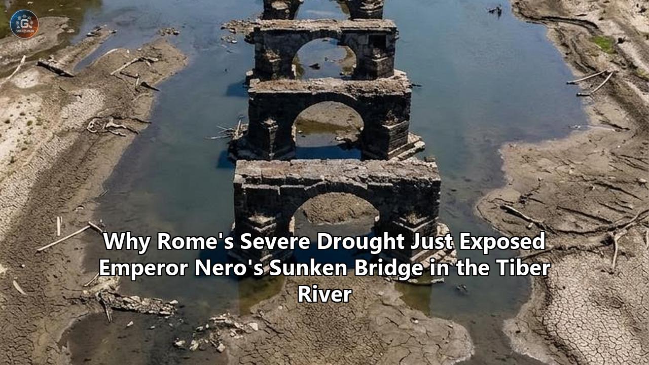
As river levels across central Italy plunged toward record lows in the summer of 2026, the Tiber River surrendered a long-submerged relic of imperial ambition: the stone footings and masonry clusters of the Pons Neronianus, widely known as Nero’s Bridge. Emerging from the water just downstream from the nineteenth-century arches of Ponte Vittorio Emanuele II, near the approaches to the Vatican and Castel Sant’Angelo, the ancient foundations rose above the waterline as the Tiber’s urban discharge rate fell below 80 cubic meters per second. That figure represents roughly half the river’s historical seasonal average of 150 to 160 cubic meters per second, marking one of the most severe hydrological depressions in Rome’s modern records.
The sudden visibility of the structure prompted international headlines framing the event as a romantic rediscovery. Behind those headlines sits a far more intricate story spanning hydrodynamics, imperial urban planning, political image-making, nineteenth-century civil engineering, and modern climatology. The exposure of the ancient pier remnants is neither a sudden archaeological mystery nor an isolated curiosity. It is the direct consequence of interconnected geological vulnerabilities, centuries of aggressive river modifications, and an escalating water crisis that is fundamentally destabilizing the Mediterranean basin.
       Upstream (Apennines & Dams)
                  │
                  ▼  [Discharge: <80 m³/s]
   ┌───────────────────────────────┐
   │  Tiber Channel (Muraglioni)   │
   │                               │
   │      [Ponte Sant'Angelo]      │
   │               │               │
   │   [Ponte Vittorio Emanuele]   │
   │               │               │
   │    ┌─────────────────────┐    │
   │    │  Pons Neronianus    │◄───┼── Exposed Pier Remains
   │    │ (Nero's Bridge Base)│    │   (Inner Meander Bend)
   │    └─────────────────────┘    │
   │                               │
   └───────────────────────────────┘
                  │
                  ▼
         Downstream (Ostia)
The Tiber Drops: Historic Masonry Breaks the Surface
The exposed structure sits in an elbow of the river that has channeled Rome’s cultural and logistical transit for millennia. As weeks of triple-digit temperatures and virtually absent rainfall dried the Tiber basin, the water retreated from the stone surfaces, exposing dark, moss-draped tufo, peperino, and travertine blocks that formed the riverbed pier foundations of the ancient crossing.
======================================================================
  TIBER RIVER HYDROLOGICAL METRICS (URBAN ROME REACH)
======================================================================
  Metric                     Historical Baseline    August 2026 Level
----------------------------------------------------------------------
  Summer Average Flow        150 – 160 m³/s         < 80 m³/s
  Peak Flood Discharge       > 1,500 – 3,000 m³/s   N/A (Drought)
  Basin Snowpack Deficit     Baseline (100%)        -45% to -60%
  Exposed Pier Footings      Submerged (0-1 visible) 2 fully visible
======================================================================
"The Tiber is facing a rather important low-water phase," stated Giovanni Giganti, coordinator of the Rome Civil Protection center for water management. "In fact, the average flow rate in the urban stretch of Rome has fallen below 80 cubic meters per second, against a historical value that is around 150 on average. We are facing a major water crisis. And it is a crisis that is also due to the fact that this winter we did have quite abundant rainfall, but then the dry periods were quite long, combined with the scarcity of snow in the Apennines."
The resurfacing blocks immediately drew onlookers along the Lungotevere, yet municipal archaeologists quickly contextualized the structure’s deep history.
"The bridge passes near the villa of Agrippina, the circus of Caligula, and then the circus of Nero, and traditionally takes the name of Nero, because objectively Nero is the most famous person linked to this area," explained Antonella Bonini, an archaeologist at Rome's cultural heritage superintendency. "The bridge, however, is considered by scholars to be older than Nero's era, built by Caligula, Nero's uncle, to connect the villa of Agrippina, who was Caligula's mother, on the other side... and we assume that it already existed in 39 AD."
Understanding why the bridge appeared requires peeling back multiple layers of operational river control, historical landscape redesign, and structural failures dating to the first century.
Hydrological Breakdown: The Anatomy of Central Italy's Water Collapse
The dramatic exposure of the ruins is primarily a story of catchment-scale hydrology. The Tiber River drains a basin covering approximately 17,375 square kilometers across four Italian regions: Emilia-Romagna, Tuscany, Umbria, and Lazio. Its primary discharge relies on two distinct water sources:
- Rain-fed runoff from central Italian tributaries, such as the Nera and Aniene rivers.
- High-elevation snowpack meltwater originating along the spine of the northern and central Apennines, primarily from the Sibillini and Reatini mountain chains.
During typical hydrological cycles, the Apennine snowpack acts as a slow-release thermal capacitor. It releases meltwater steadily from late spring into July, preventing the main river trunk from dropping below its critical ecological baseline.
In 2026, severe meteorological shifts disrupted that regulatory mechanism. While winter precipitation across central Italy was near historical volume baselines, a disproportionate percentage fell as liquid precipitation rather than snow due to elevated atmospheric temperatures. Without persistent high-altitude snowpack to feed headwater karst aquifers and tributaries, the river basin entered late spring with empty storage reserves.
               [Apennine Mountain Headwaters]
                             │
              ┌──────────────┴──────────────┐
              ▼                             ▼
       [Rainfall Runoff]            [Snowpack Storage]
      (Fast winter surge;           (Critically reduced;
       no seasonal buffer)           zero summer melt)
              │                             │
              └──────────────┬──────────────┘
                             ▼
         [Upstream Hydroelectric Reservoirs]
        (Corbara / Alviano storage depleted)
                             │
                             ▼  [Minimum Vital Flow Constraints]
                 [Rome Urban Tiber Reach]
                (Discharge drops < 80 m³/s)
                             │
                             ▼
     [Hydraulic Drop Exposes Ancient Foundation Masonry]
When multi-week anticyclonic pressure systems settled over the Italian peninsula, daily evaporation rates spiked while agricultural extractions surged. Upstream hydroelectric dams and agricultural impoundments—most notably Lake Corbara in Umbria and the Alviano regulatory reservoir—were forced to throttle releases to preserve their own minimum operating thresholds. The cascading effect arrived at the northern gates of Rome, near the Castel Giubileo hydroelectric barrage, which could no longer pass enough volume to maintain standard urban river depth.
With the flow reduced to a trickle relative to its channel dimensions, the water surface dropped below the upper leveling courses of the submerged Roman piers, laying bare the hydraulic anatomy of the ancient riverbed.
The Riverbed Flume: How the 19th-Century Muraglioni Altered Tiber Physics
The emergence of the bridge cannot be understood without examining the drastic structural reshaping of Rome's river corridor in the late nineteenth century.
For millennia, the Tiber was an unconstrained, meandering river that periodically swamped Rome's alluvial flats. Its banks sloped gently, lined with sandy beaches, rip-rap ramps, small boat wharves (scali), and riverside gardens. In December 1870, a catastrophic flood submerged the Piazza del Popolo, the Pantheon, and the surrounding low-lying districts under more than 17 meters of water, causing catastrophic economic paralysis in the newly established capital of unified Italy.
======================================================================
     CROSS-SECTION COMPARISON: HISTORIC VS. MODERN TIBER AT ROME
======================================================================

 HISTORIC TIBER (Antiquity – 1876):
 ~~~~~~~~~~~~~~~~~~~~~~~~~~~~~~~~~~
 Soft Alluvial Bank                                    Alluvial Plain
 ─────┐                                                      ┌────────
      \   Variable Water Level (Wide Floodplain Spread)      /
       \~~~~~~~~~~~~~~~~~~~~~~~~~~~~~~~~~~~~~~~~~~~~~~~~~~~~/
        \___[Pons Neronianus Pier 1]___[Pier 2]___[Pier 3]_/
            (Sediment accumulation, shifting bed level)

 MODERN CANALIZED TIBER (1876 – Present):
 ~~~~~~~~~~~~~~~~~~~~~~~~~~~~~~~~~~~~~~~~
 [Lungotevere Street]                            [Lungotevere Street]
 ▓▓▓▓▓▓▓▓▓▓▓▓▓▓▓▓▓                                 ▓▓▓▓▓▓▓▓▓▓▓▓▓▓▓▓▓▓
 │ 39-foot High Travertine Wall (Muraglioni)     Travertine Wall   │
 │                                                                 │
 │              Tiber Width Constricted to ~100 Meters             │
 │                                                                 │
 │                                                                 │
 │  Normal Water Level: ~~~~~~~~~~~~~~~~~~~~~~~~~                  │
 │                                                                 │
 │  Drought Level:       - - - - - - - - - - -                     │
 │                             [Exposed Stone Pier]                │
 └───────────────────────────────┴─────────────────────────────────┘
                 (Scoured bed, altered flow velocity)
======================================================================
In 1876, the Italian government launched a monumental civil engineering project led by engineer Raffaele Canevari: the construction of the Muraglioni. These 39-foot-tall (12-meter) vertical travertine retaining walls encased the Tiber within a continuous, stone-lined canyon measuring roughly 100 meters wide.
While the Muraglioni effectively shielded the modern city from all but the most catastrophic surges, they radically altered the hydraulic behavior of the river:
- Velocity and Scouring: By eliminating natural overflow floodplains, the walls concentrated hydraulic force directly downward onto the river bottom. During high water, the confined river acts as a high-velocity flume, aggressively scouring fine alluvial sediments that previously covered ancient architectural debris.
- Loss of Sediment Buffering: The riverbed, historically subject to cycles of silt deposition that buried ancient remains under meters of mud, was transformed into an erosive channel.
- Amplified Visual Droop: When flow volume collapses during droughts, the rigid, vertical geometry of the walls provides no natural shoreline mitigation. The water drop is stark and abrupt, creating rapid structural exposure of the river floor.
The nineteenth-century engineering campaign had an even more direct, physical impact on the bridge itself. As Canevari’s engineers straightened the riverbed and cleared the channel for commercial steamship navigation between the port of Ripa Grande and upstream docks, they viewed the surviving ancient bridge ruins as dangerous navigation hazards.
Historical accounts, corroborated by modern architectural surveys, confirm that in the late 1870s and 1880s, construction crews used explosives and heavy mechanical dredging equipment to blast and remove two to three of the four original stone piers of the Pons Neronianus down to the riverbed. Only the basal foundations of the eastern piers survived this industrial demolition.
When low water levels reveal Nero's bridge Tiber river observers are not seeing an intact bridge that slowly broke down under natural elements; they are looking at the heavily truncated, dredged stumps left behind by nineteenth-century urban channel engineers.
Engineering on an Unstable Bend: The Fatal Geo-Hydrological Flaw of the Pons Neronianus
Long before modern engineers dynamited its remains, the bridge suffered from a fundamental engineering mistake made during the early Roman Empire.
Roman civil engineers were master builders of hydraulic infrastructure, but their knowledge of geomorphology was primarily empirical rather than theoretical. That limitation is nowhere clearer than in the bridge's geographical placement.
                     Outer Bank (Severe Hydraulic Scour)
                  ~~~~~~~~~~~~~~~~~~~~~~~~~~~~~~~~~~~~~~~~
                 /                                        \
  Tiber Flow ───►                                          │
                 \                                        /
                  ~~~~~~~~~~~~~~~~~~~~~~~~~~~~~~~~~~~~~~~~
                     Inner Bank (Point Bar Sedimentation)

       [!] Pons Neronianus constructed across a sharp meander bend:
           - Outer piers subjected to destructive lateral vortices.
           - Inner piers destabilized by wandering sediment beds.
           - Result: Chronic structural failure within 150 years.
The bridge spanned the Tiber along a tight, concave meander bend where the river sweeps around the western edge of the Campus Martius. In fluvial geomorphology, a sharp river bend is inherently dynamic:
- The outer bank experiences maximum flow velocity, shear stress, and destructive helical scour that erodes bridge abutments.
- The inner bank experiences deceleration, causing massive, shifting sediment deposits (point bars) that alter the channel floor's bearing capacity.
Prof. Rabun Taylor, a classics professor at the University of Texas at Austin and a leading expert on Rome's ancient water systems, has documented the hydraulic vulnerabilities that plagued the bridge from its inception.
"The bridge was built on a tight bend in a floodplain," Taylor noted in his analytical studies of Rome's river infrastructure. "River bends cutting through pure sediment tend to wander and change shape, so their banks are prone to losing contact with bridge abutments. That's probably what happened to Nero's bridge—and it may well have happened by the mid-200s AD, less than two centuries after Nero's death."
=================================================================================
 ROMAN TIBER BRIDGES: COMPARATIVE STRUCTURAL & GEOMORPHOLOGICAL ANALYSIS
=================================================================================
 Bridge Name          Built     Geomorphic Location        Structural Fate
---------------------------------------------------------------------------------
 Pons Fabricius       62 BC     Straight channel reach,    Survives fully intact;
                                anchored on Tiber Island   still carrying pedestrian
                                bedrock foundation.        traffic today.

 Pons Aelius          134 AD    Straight reach upstream,   Survives substantially;
 (Ponte Sant'Angelo)            symmetrical flow profile,  converted to pedestrian
                                optimized pier openings.   monumental bridge.

 Pons Neronianus      c. 39 AD  Tight meander bend on      Failed early (c. 250 AD);
 (Nero's Bridge)                unconsolidated alluvial    dismantled; remaining
                                floodplain sediment.       piers blasted in 1880s.
=================================================================================
A comparison with surviving Roman bridges highlights this design flaw. Pons Fabricius, built in 62 BC, connects the left bank to Tiber Island. By anchoring its massive tufa and travertine piers into the natural geological spine of the island and incorporating an arched relief opening to relieve flood pressure, the builders insured the bridge against hydraulic failure for more than two millennia.
Similarly, Emperor Hadrian’s Pons Aelius (now Ponte Sant'Angelo), constructed around 134 AD less than 200 meters upstream from Nero’s bridge, was positioned across a far straighter, more hydraulically stable reach of the river.
The builders of the Pons Neronianus lacked those advantages. The crossing was placed not to optimize hydraulic longevity, but to satisfy the political, private, and ceremonial demands of the Julio-Claudian imperial family.
Caligula, Nero, and Imperial Propaganda: Deconstructing the Historical Narrative
The name "Nero’s Bridge" remains one of the most persistent misnomers in popular Roman archaeology. Both epigraphic and topographical evidence indicate that the bridge was conceived, and likely constructed, under Nero's predecessor and uncle, Emperor Gaius Caesar Augustus Germanicus—better known as Caligula.
                     CHRONOLOGY OF THE PONS NERONIANUS
────────────────────────────────────────────────────────────────────────────
 c. 39 AD   Emperor Caligula begins bridge construction to link Campus
            Martius with the imperial gardens (Horti Agrippinae) and circus.
────────────────────────────────────────────────────────────────────────────
 54–68 AD   Emperor Nero completes/renovates the bridge to access his expanded
            Circus of Nero and incorporates it into the Via Triumphalis.
────────────────────────────────────────────────────────────────────────────
 c. 134 AD  Hadrian inaugurates Pons Aelius upstream, shifting massive
            traffic away from the structurally troubled Neronian crossing.
────────────────────────────────────────────────────────────────────────────
 c. 250 AD  Hydraulic scour and bank detachment cripple the bridge; superstructure
            is dismantled to salvage stone for the Pons Probi downstream.
────────────────────────────────────────────────────────────────────────────
 4th Cent.  Bridge is omitted from regional catalogs (Cataloghi Regionari);
            referred to colloquially in late antiquity as Pons Ruptus.
────────────────────────────────────────────────────────────────────────────
 1876–1885  Post-unification engineers dynamite protruding piers to clear
            river navigation for steam traffic during Muraglioni construction.
────────────────────────────────────────────────────────────────────────────
During Caligula's reign (37–41 AD), the right bank of the Tiber (Ager Vaticanus) was not a densely populated urban district, but an expanse of rolling, marshy countryside dominated by private imperial estates. Caligula inherited the Horti Agrippinae—the extensive riverside gardens developed by his mother, Agrippina the Elder. To stage private chariot races and equestrian spectacles, Caligula began building an imperial circus on the Vatican plain.
A dedicated, direct crossing was required to link these private pleasure grounds to the urban centers of the Campus Martius across the river.
[Campus Martius] ═════════════════════════════════════════════╗
(Urban Centers, Military Assembly, Drained Marshland)         ║
                                                              ▼
                                                   [Pons Neronianus]
                                                   (Imperial Bridge)
                                                              │
                                                              ▼
[Ager Vaticanus / Vatican Plain] ═════════════════════════════╝
(Horti Agrippinae, Circus of Nero, Later Site of St. Peter's)
Nero (reigned 54–68 AD) expanded the circus complex, enlarged the estate grounds, and heavily utilized the route. Tacitus famously recorded that within this circus complex, Nero executed Christians following the Great Fire of Rome in 64 AD.
The crossing became part of the Via Triumphalis, the ceremonial pathway along which returning Roman generals and emperors led victory processions into the heart of the city. Because Nero attached his name to public projects across the imperial capital, and because the Vatican plain retained the colloquial moniker "Plains of Nero" for centuries, the bridge became permanently associated with his reign in historical memory.
Architectural historian Nicholas Temple of London Metropolitan University has pointed out the uncertain timeline of the bridge’s earliest phases:
"The origins of the bridge are uncertain, given that it is likely a bridge existed here before Nero's reign and therefore the Pons Neronianus was probably a reconstruction of an earlier crossing," Temple noted in studies on Rome's ceremonial urban grid. "The Pons Neronianus was both strategically and symbolically important. It has potentially a double significance, as the crossing point into Rome of triumphal armies, and in the opposite direction for St. Peter's journey to the site of crucifixion."
The historical name itself is a medieval artifact. Robert Coates-Stephens, a leading archaeologist at the British School at Rome, noted that the title Pons Neronianus "appears for the first time only in the 12th-century catalogues of Rome's monuments," most notably in the pilgrim guide Mirabilia Urbis Romae.
By the early fourth century, the bridge had already vanished from imperial civil registers.
"We know that it was certainly no longer in use, at least at the end of the third or beginning of the fourth century," explained archaeologist Antonella Bonini. "In the registers of ancient Rome's neighborhoods (Cataloghi Regionari), drawn up between the Diocletian and Constantinian ages, this bridge is no longer mentioned. The Pons Aelius bridge is listed in its place."
By that time, the river had claimed the crossing, and medieval Romans knew it simply as Pons Ruptus—the Broken Bridge.
Cannibalization and Concrete: The Forensic Archaeology of the Submerged Foundations
The physical remains of Nero's bridge Tiber river currents left behind offer insight into Roman marine concrete engineering and the late-antique recycling of building materials.
======================================================================
     STRUCTURAL ANATOMY OF A SUBMERGED ROMAN BRIDGE PIER
======================================================================

     [ Masonry Ashlar Blocks: Travertine / Peperino Shell ]
     ┌──────────────────────────────────────────────────┐
     │ ┌──────────────────────────────────────────────┐ │
     │ │                                              │ │
     │ │   Core: Opus Caementicium                    │ │
     │ │   (Lime + Pozzolana Mortar + Tufo Aggregate) │ │
     │ │                                              │ │
     │ └──────────────────────────────────────────────┘ │
     └──────────────────────────────────────────────────┘
       │  │  │  │  │  │  │  │  │  │  │  │  │  │  │  │  │
       ▼  ▼  ▼  ▼  ▼  ▼  ▼  ▼  ▼  ▼  ▼  ▼  ▼  ▼  ▼  ▼  ▼
     [ Cofferdam Piles: Oak / Alder Wood Driven Deep into Mud ]
     [ Forms anaerobic seal; preserved for 2,000 years under water ]
======================================================================
To construct deep-water piers in the Tiber's unpredictable currents, Roman engineers utilized a specialized method recorded by the architect Vitruvius in his treatise De Architectura (Book V):
- Workers drove a double ring of oak or alder timber piles (palificazioni) deep into the riverbed silt to form a watertight cofferdam.
- After pumping out the interior water with Archimedean screws or bucket wheels, they excavated down to solid clay strata.
- If bedrock was unreachable, they drove closely spaced, charred wooden pilings into the soft subsoil to compress the sediment and create a stable bearing platform.
- Within this enclosure, masons poured opus caementicium—a hydraulic mortar made by mixing slaked lime (calx) with volcanic ash (pozzolana) mined from the Alban Hills or the Phlegraean Fields.
This pozzolanic concrete possessed the unique chemical property of curing underwater, forming calcium-aluminum-silicate-hydrate (C-A-S-H) crystal matrixes that grew stronger through ongoing contact with mineral-rich river water.
The exterior of each pier was faced with dressed ashlar blocks of hard travertine and fire-resistant peperino stone, bound together with iron and lead clamps to resist the lateral pressure of floodwaters.
               [Hydraulic Distress at Pons Neronianus]
                                  │
                                  ▼
           [Piers Suffer Irreparable Scour & Settling]
                                  │
                                  ▼
      [Emperor Probus / Theodosius Authorizes Bridge Dismantling]
                                  │
                                  ▼
       [Ashlar Blocks Cleanly Severed and Transported Downstream]
                                  │
                                  ▼
              [Reassembled to Construct the Pons Probi]
When geomorphological shifting compromised the bridge's structural integrity in the third century, Roman civil authorities made a calculated decision: rather than repeatedly rebuilding piers in an unstable bend, they dismantled the bridge's upper superstructure block by block.
Taylor’s architectural research suggests that the stone piers were carefully disassembled and shipped downstream to build the Pons Probi (later restored as the Pons Theodosii) near the Aventine Hill—a location far better suited for cross-river commercial transport.
When nineteenth-century engineers inspected the riverbed, they noted that the surviving stone piers of the Neronian bridge had been severed with deliberate, masonry-level precision, rather than sheared off by natural collapse.
The Conservation Dilemma: When Drought Threatens Submerged Antiquity
While receding waters provide rare research windows for field archaeologists, prolonged exposure presents severe structural threats to submerged Roman antiquities.
                               [Prolonged Drought]
                                        │
                                        ▼
                          [River Water Levels Plunge]
                                        │
               ┌────────────────────────┴────────────────────────┐
               ▼                                                 ▼
     [Aerobic Oxidation]                               [Atmospheric Exposure]
  Oxygen degrades ancient oak                       Evaporative drying weakens
  and alder foundation piles.                       pozzolanic concrete mortar.
               │                                                 │
               └────────────────────────┬────────────────────────┘
                                        │
                                        ▼
              [High-Velocity Winter Flood Refilling & Scour Surge]
                                        │
                                        ▼
                  [Accelerated Structural Breakdown of Ruins]
Submerged heritage preserved within alluvial riverbeds survives largely through anaerobic equilibrium. Submerged timber pile foundations, ancient mortar, and organic artifacts trapped in fine river sediments remain protected from atmospheric oxygen, fungal rot, and aggressive bio-colonization.
When drought exposes these materials:
- Oxidation of Foundation Timbers: The wooden pilings that support the concrete cores dry out and oxidize rapidly upon contact with air, initiating cellular collapse within centuries-old oak and alder elements.
- Mortar Matrix Breakdown: Pozzolanic concrete subjected to intense solar baking experiences evaporative drying, surface spalling, and microscopic micro-fracturing along ancient mortar joints.
- Thermal Shock and Reflooding: When winter rains inevitably return, fast-moving, debris-laden floodwaters smash against these destabilized surfaces, accelerating mechanical erosion and washing away exposed structural mortar.
To address these conservation challenges without relying on intrusive, costly excavations, modern cultural heritage teams have turned to advanced non-invasive mapping technologies.
Under the ongoing Archaeological Survey of the Tiber—a collaborative effort between Rome's Special Superintendency for Archaeology, Fine Arts, and Landscape, Italy's Central Institute for Restoration (ICR), and British marine survey specialists—researchers deployed high-resolution bathymetric LiDAR and NORBIT Winghead multibeam sonar along a 12-kilometer stretch of the urban riverbed.
======================================================================
 MODERN NON-INVASIVE ARCHAEOLOGICAL TECHNOLOGIES USED ON THE TIBER
======================================================================
 Technology             Operational Mechanism      Survey Target
----------------------------------------------------------------------
 Bathymetric LiDAR      Green-wavelength laser     Submerged masonry
                        water-penetrating scans    elevation & topography

 Multibeam Sonar        High-frequency acoustic    3D riverbed profiling;
 (NORBIT Winghead)      backscatter imaging        sub-meter pier mapping

 Sub-Bottom Profilers   Low-frequency acoustic     Sub-surface timber
                        stratigraphic penetration  piling identification
======================================================================
These geophysical campaigns confirmed that while only one or two masonry clusters emerge above the waterline during severe droughts, the entire submerged layout of the Pons Neronianus remains mapped below the sediment. Three-dimensional acoustic scans have traced the hidden subterranean footprints of the destroyed piers, the remnants of the wooden cofferdam enclosures, and centuries of accumulated artifacts embedded in the mud around the footings.
Managing Modern Thirst Against Ancient Architecture
The recurring emergence of the ruins has transformed Nero's bridge Tiber river sites from isolated historical anomalies into urgent indicators of Italy’s climate and water-security challenges. The dry conditions exposing the ancient stones are directly connected to escalating resource competition across Lazio and the broader Italian peninsula.
                ┌──────────────────────────────────────┐
                │ Central Italy Water Resource Balance │
                └──────────────────┬───────────────────┘
                                   │
         ┌─────────────────────────┼─────────────────────────┐
         ▼                         ▼                         ▼
 [Metropolitan Rome]       [Agro Romano Crops]      [Natural Ecosystems]
  Drinking supply from      Heavy irrigation demands  Minimum Vital Flow
  karstic spring sources    draw from surface basins  requirements strained
 (Peschiera-Capore system) (Tiber / Aniene system)   across river network
Metropolitan Rome relies on high-yield karstic mountain springs—primarily the Peschiera-Capore system in the Sabine Hills, which supplies more than 70% of the city’s potable water via monumental aqueduct systems.
However, surface water networks remain critical:
- Agricultural Pressures: The fertile farmlands of the Agro Romano and the Tiber Valley depend heavily on direct surface water withdrawals for crop irrigation, placing immense pressure on tributary streams during dry periods.
- Ecological Thresholds: Italian water basin authorities must balance irrigation permits against strict European Union mandates requiring the preservation of the Deflusso Minimo Vitale (DMV)—the minimum environmental flow needed to prevent ecological collapse, fish die-offs, and saltwater intrusion from the Mediterranean at the Tiber's mouth in Fiumicino and Ostia.
- Lake Depletion Safeguards: Following the severe drought of 2017, when emergency pumping from Lake Bracciano pushed the lake toward ecological collapse and sparked legal battles, extraction from natural regional lake reserves was sharply limited. That puts the full burden of surface-water deficits directly onto the river network.
======================================================================
 REGIONAL WATER DEMAND & RESOURCE DISTRIBUTION PROFILE (LAZIO)
======================================================================
 Potable Water Source:        ~70-80% Peschiera-Capore Springs System
 Secondary Drinking Supply:   Appio-Claudio, Marcio, & Lake Reserves
 Irrigation Demand:           Surface withdrawal (Tiber & Aniene Basins)
 Environmental Redlines:      Strict limits on Lake Bracciano pumping;
                              Mandatory Minimum Vital Flow at river mouth.
======================================================================
Civil Protection authorities and hydro-engineers acknowledge that exposure events for the Pons Neronianus will become increasingly common as Mediterranean weather patterns shift toward extended summer dry spells punctuated by intense, erosive downpours.
The reappearance of the bridge provides a clear visual demonstration of a changing climate. A structure built for imperial vanity on a geologically flawed bend—then abandoned, dismantled, and dynamited—now acts as an open-air gauge for the modern city's fragile water supply.
As long as the Mediterranean's hydrological systems remain under strain, the stone footprints of Caligula’s and Nero’s forgotten river crossing will continue to rise from the mud, reminding the city above that even the grandest engineering works remain vulnerable to the natural forces of water and time.
Reference:
- https://www.youtube.com/watch?v=vtJxrvexEqo
- https://www.rustourismnews.com/2026/08/19/drought-reveals-ancient-roman-bridge-near-the-vatican/
- https://vancouverisland.ctvnews.ca/sci-tech/article/low-water-in-romes-drought-hit-tiber-river-exposes-ancient-ruins-of-neros-bridge/
- https://en.wikipedia.org/wiki/Pons_Neronianus
- https://www.thenational.scot/news/national/26463182.neros-bridge-emerges-tiber-river-rome-faces-water-crisis/
- https://newswav.com/video/drought-reveals-emperor-nero-s-bridge-beneath-rome-s-tiber-river-V2608_Cf7OIr
- https://www.livescience.com/drought-reveals-roman-emperor-nero-bridge
- https://newscop.com.au/2022/07/23/italian-drought-reveals-ancient-bridge-in-romes-tiber-river/
- https://www.thecooldown.com/green-tech/rome-drought-ancient-bridge-tiber-exposed/
- https://www.finestresullarte.info/en/archaeology/underwater-archaeology-in-rome-hundreds-of-submerged-archaeological-artifacts-discovered-in-the-tiber-river
- https://apnews.com/article/italy-climate-and-environment-86882350f7a5b79e64b378a8e7235352
- https://newswav.com/video/drought-reveals-emperor-nero-s-bridge-beneath-rome-s-tiber-river-V2608_Cf7OIr
- https://www.researchgate.net/publication/323138661_Sustainability_of_Water_Withdrawals_in_the_Tiber_River_Basin_Central_Italy
- https://www.turismoroma.it/en/itineraries/passage-over-tiber-rome%E2%80%99s-seven-most-iconic-bridges
- https://myvintagejourneys.blogspot.com/2019/06/the-tiber-river-of-rome.html
- https://en.wikipedia.org/wiki/Pons_Neronianus
- https://www.facebook.com/21WFMJ/posts/romes-ancient-neros-bridge-has-reemerged-from-the-tiber-river-as-exceptionally-l/1488403473333907/
- https://www.livius.org/articles/place/rome/rome-photos/rome-bridge-of-nero/
- https://archaeology.org/news/2019/05/14/220718-rome-pons-neronianus/
- https://newscop.com.au/2022/07/23/italian-drought-reveals-ancient-bridge-in-romes-tiber-river/
- https://en.wikisource.org/wiki/1911_Encyclop%C3%A6dia_Britannica/Rome
- https://waters.iath.virginia.edu/taylor_bridges.html
- https://www.researchgate.net/publication/236888454_Spatial_and_Time_Analysis_of_Rainfall_in_the_Tiber_River_Basin_Central_Italy_in_relation_to_Discharge_Measurements_1920-2010