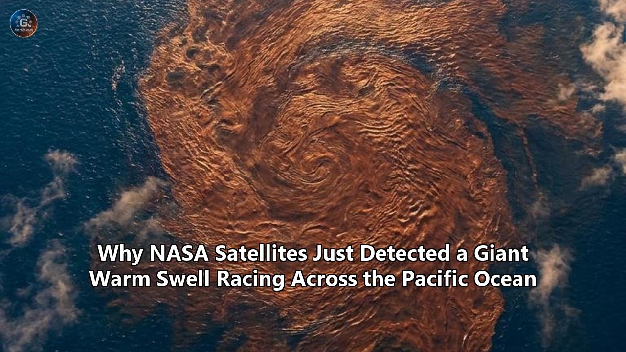
In mid-June 2026, NASA and its international partners released a series of satellite observations revealing that a massive pulse of warm water, hundreds of kilometers wide, has completed its journey across the equatorial Pacific and arrived off the western coast of South America. Captured by the Sentinel-6 Michael Freilich satellite, this sub-surface wave represents a dramatic redistribution of thermal energy in the world’s largest ocean. The data shows that by mid-May 2026, sea surface heights near Peru, Ecuador, and Colombia had risen more than 15 centimeters (5.9 inches) above long-term averages. Because water expands as it warms, this pronounced regional elevation serves as a direct thermodynamic indicator of rising temperatures deep below the surface.
Climatologists and oceanographers view this development as a clear and potent signal that a major El Niño event is actively forming in the tropical Pacific. The wave observed by Sentinel-6 is known as a downwelling equatorial Kelvin wave. These waves act as the primary oceanic transport mechanism that carries heat from the western Pacific warm pool to the eastern boundary of the ocean, effectively laying the groundwork for the atmospheric shifts that define El Niño.
The implications of this oceanic surge are global. By altering the distribution of heat in the Pacific, the emerging El Niño threatens to disrupt weather patterns worldwide, potentially bringing torrential rains and flooding to the Americas while triggering severe droughts, agricultural failures, and wildfire conditions across Southeast Asia, Australia, and parts of Africa. As the international community prepares for these disruptions, the 2026 Pacific Ocean warm swell serves as a valuable case study. It illustrates how advanced spaceborne instrumentation provides early warning capabilities that can translate satellite observations into proactive, global climate resilience.
Section 1: The June 2026 Satellite Detection: A Continental-Scale Pulse of Heat
The June 2026 announcement by NASA’s Jet Propulsion Laboratory (JPL) and its European collaborators represents a critical milestone in global climate monitoring for the year. Using precision radar altimetry, the Sentinel-6 Michael Freilich satellite tracked the birth, propagation, and ultimate arrival of several warm Kelvin waves starting in early 2026. The data reveals a highly dynamic oceanic system transitioning away from the neutral conditions of early winter toward a robust warm state.
The May/June Observations
According to the processed altimetry maps, the Pacific Ocean warm swell became highly pronounced as it approached the South American coastline. In early 2026, Sentinel-6 detected a modest, precursor Kelvin wave forming near Micronesia in late January. While this initial wave dissipated by mid-February, a much larger and more sustained wave emerged in early March and began a steady, eastward march across the equatorial corridor.
By mid-May 2026, this second, dominant wave reached the coastal waters off Peru, Ecuador, and Colombia. The resulting sea level anomalies—visualized in satellite data as broad bands of yellow, orange, and red—indicate sea levels rising more than 15 centimeters above the historical baseline. Because these elevation anomalies correspond directly to thermal expansion, scientists can calculate the immense volume of subsurface heat that has accumulated along the South American coast, effectively shutting down the normal upwelling of cold, nutrient-rich deep waters.
The Expert Consensus
The scale and velocity of the warm waves detected in early 2026 have drawn close comparison to historical events. Climatologists emphasize that while every El Niño cycle exhibits unique characteristics, the presence of consecutive, strong downwelling Kelvin waves is a reliable precursor to a significant global climate event.
Nadya Vinogradova Shiffer, lead program scientist at NASA Headquarters, noted that satellite altimeters like Sentinel-6 Michael Freilich are essential for tracking these massive Kelvin waves as they cross the Pacific. Shiffer explained that these measurements capture the fundamental changes in Earth's ocean thermodynamics, which in turn helps scientists improve forecasts of weather extremes and allows communities to prepare for potential coastal hazards.
Josh Willis, a sea-level researcher at JPL, pointed out that the 2026 wave sequence began somewhat later than the massive El Niño cycles of 1997 and 2015. However, Willis observed that the system has rapidly gained momentum, stating that it is beginning to catch up and that scientists are closely monitoring how large it will ultimately become.
2026 Equatorial Pacific Wave Timeline:
+-------------------+-----------------------------------------+-----------------------------------------+
| Date Range        | Wave Location & Status                  | Observed Impact on Sea Surface Height  |
+-------------------+-----------------------------------------+-----------------------------------------+
| Late Jan - Feb    | Micronesia (Western Pacific)            | Minor initial swell; dissipated quickly |
| Early March       | Central Pacific                         | Large, sustained wave initiated         |
| Mid-May           | South American Coast (Peru/Ecuador)     | Sea levels rise >15 cm above average    |
| June (Current)    | Eastern Boundary / Coastal Propagation  | Warm pool consolidates off South Amer.  |
+-------------------+-----------------------------------------+-----------------------------------------+
Section 2: The Physical Anatomy of a Kelvin Wave
To understand the significance of the 2026 detection, it is necessary to examine the physical mechanisms governing equatorial Kelvin waves. These waves are not typical surface gravity waves, like those that break on a beach. Instead, they are massive, slow-moving internal waves that travel along the thermocline—the boundary layer that separates the warm, well-mixed upper ocean from the cold, dense water below.
The Shallow-Water Equations and Equatorial Dynamics
Equatorial Kelvin waves are unique because they are trapped along the equator by the Coriolis effect. The mathematical description of these waves relies on the shallow-water equations on an equatorial $\beta$-plane, where the Coriolis parameter $f$ is approximated as:
$$f \approx \beta y$$
In this equation, $y$ represents the meridional distance from the equator, and $\beta$ is the gradient of the Coriolis parameter at the equator.
Because the Coriolis force changes sign at the equator (pointing rightward in the Northern Hemisphere and leftward in the Southern Hemisphere), the equator acts as a natural waveguide. Any disturbance in sea surface height or thermocline depth along the equator is laterally constrained.
The waves can only propagate eastward, traveling at a characteristic speed $c$ determined by the gravity of the ocean's density structure:
$$c = \sqrt{g' H}$$
Here, $g'$ is the reduced gravity, which accounts for the small density difference between the warm upper layer and the cold deep ocean, and $H$ is the depth of the thermocline. In the equatorial Pacific, this propagation speed typically ranges from 2 to 3 meters per second, meaning a wave takes approximately two to three months to traverse the entire basin.
Westerly Wind Bursts and the Warm Pool
Under normal, non-El Niño conditions, the equatorial Pacific is dominated by strong easterly trade winds blowing from east to west. These winds push warm surface water westward, piling it up in the western Pacific near Indonesia and Micronesia. This process creates the Western Pacific Warm Pool, where sea levels are typically higher and the thermocline is much deeper than in the eastern Pacific.
The generation of a downwelling Kelvin wave requires a disruption of this equilibrium. This typically occurs in the form of a Westerly Wind Burst (WWB)—a brief period, lasting from several days to a few weeks, where the prevailing easterly winds weaken or completely reverse direction, blowing from west to east.
When these westerlies blow over the Western Pacific Warm Pool, they push the accumulated warm water back toward the east. This initiates a downwelling Kelvin wave. As the wave propagates eastward, it deepens the thermocline along its path. Because warm water is less dense and occupies more volume than cold water, this deepening of the thermocline manifests at the ocean surface as a broad, low-amplitude rise in sea surface height, which can be detected by satellite altimeters.
Normal Pacific Conditions:
[West: Indonesia]                                       [East: South America]
Warm Pool (High Sea Level) ---- Easterly Winds ---> Cold Water Upwelling (Low Sea Level)
Thermocline is Deep                                     Thermocline is Shallow

El Niño / Kelvin Wave Transition:
[West: Indonesia]                                       [East: South America]
Westerly Wind Burst --->   [Downwelling Kelvin Wave] ---> Deepens Thermocline
Thermocline Rises          (Warm Swell Moves East)       Sea Level Rises, Upwelling Stops
Thermocline Dynamics
As the Pacific Ocean warm swell reaches the eastern boundary near South America, its primary physical impact is the suppression of coastal upwelling. Normally, the southwesterly winds along the coast of Peru drive offshore Ekman transport, pulling cold, nutrient-rich water up from the deep ocean to the surface. This upwelling supports one of the most productive marine ecosystems and commercial fisheries in the world.
However, when a downwelling Kelvin wave arrives, the local thermocline is pushed deep below the reach of the upwelling winds. Instead of drawing up nutrient-laden cold water, the winds upwell the warm, nutrient-poor water carried by the Kelvin wave. This leads to a rapid rise in sea surface temperatures along the coast of South America, which can have immediate and devastating impacts on marine life, particularly anchovy and sardine populations, and the seabirds and marine mammals that depend on them.
Section 3: Spaceborne Oceanography: The Technology Tracking the Pulse
Because Kelvin waves are incredibly broad—often spanning hundreds of kilometers—and have a surface amplitude of only a few centimeters, they are virtually invisible to observers on ships or at coastlines. Detecting these massive oceanic features requires the synoptic, high-precision view provided by spaceborne radar altimeters.
Altimetry Principles:
[Satellite]
   |
   | (Radar Pulse Transmitted)
   v
[Ocean Surface]  <--- High Sea Level (Warm Water / Thermal Expansion)
   ^
   | (Radar Pulse Reflected)
   |
[Satellite Sensors Calculate Time of Flight to Determine Ocean Height]
Sentinel-6 Michael Freilich: Precision Down to Fractions of an Inch
The primary instrument tracking the 2026 Pacific Ocean warm swell is the Sentinel-6 Michael Freilich satellite. Launched in December 2020 as a joint endeavor of NASA, ESA, EUMETSAT, NOAA, and the French space agency CNES, the satellite is designed to maintain the continuous, decades-long record of global sea level observations initiated by the TOPEX/Poseidon mission in 1992.
Sentinel-6 carries the Poseidon-4 radar altimeter, which operates in a dual-frequency mode (C-band and Ku-band) to correct for atmospheric delays caused by the ionosphere. The altimeter operates by transmitting microwave pulses toward the ocean surface and measuring the precise travel time of the reflected echo. By combining this travel time with highly accurate orbital tracking systems—such as GPS and the Doppler Orbitography and Radiopositioning Integrated by Satellite (DORIS) system—Sentinel-6 can determine the distance from the satellite to the ocean surface with sub-centimeter accuracy.
Every 10 days, Sentinel-6 maps the sea surface height of approximately 95% of the ice-free ocean. This repetitive, high-precision coverage is critical for detecting the subtle, low-frequency ocean signals associated with the ENSO cycle. When the satellite passes over an area where the ocean is warmer than average, the thermal expansion of the water column causes the sea level to bulge upward by several centimeters. Sentinel-6 detects this bulge, allowing researchers to map the location, speed, and thermal content of Kelvin waves as they transit the Pacific.
SWOT: Resolving Coastal and Fine-Scale Structures
While Sentinel-6 provides the global, long-term context, the international Surface Water and Ocean Topography (SWOT) satellite offers unprecedented spatial resolution. Launched in December 2022 by NASA and CNES, SWOT utilizes a novel instrument called the Ka-band Radar Interferometer (KaRIn).
Unlike traditional altimeters that measure sea level only along a narrow, directly-nadir track, KaRIn uses two radar antennas mounted at the ends of a 10-meter boom to collect a pair of wide-swath data measurements. This interferometric approach allows SWOT to measure water height across a swath 120 kilometers wide, providing a two-dimensional map of the ocean surface at a spatial resolution of 15 to 25 kilometers—an order of magnitude finer than previous missions.
Comparison of Spaceborne Altimetry Missions:
+-----------------------------------+-----------------------------------+-----------------------------------+
| Feature                           | Sentinel-6 Michael Freilich       | SWOT (Surface Water & Ocean Topo) |
+-----------------------------------+-----------------------------------+-----------------------------------+
| Launch Date                       | December 16, 2020                 | December 16, 2022                 |
| Orbit Repeat Cycle                | 10 Days                           | 21 Days                           |
| Spatial Coverage                  | Nadir-only tracks (global grid)   | Wide-swath (120 km width)         |
| Primary Instrument                | Poseidon-4 (Ku/C-band Altimeter)  | KaRIn (Ka-band Interferometer)    |
| Native Ocean Resolution           | ~50 to 100 km (processed)         | 15 to 25 km (two-dimensional)     |
| Main Strength for ENSO            | Rapid, continuous temporal tracking| Fine-scale coastal interactions   |
+-----------------------------------+-----------------------------------+-----------------------------------+
During the 2026 warming event, SWOT's high-resolution capabilities have been critical for observing how the arriving Pacific Ocean warm swell interacts with complex coastal topography along the Americas. In the coastal zones of Peru and Ecuador, where the continental shelf is narrow and fractured by submarine canyons, traditional nadir altimeters often struggle with land contamination in their radar footprints. SWOT's KaRIn instrument, however, can resolve sea level height right up to the coastline. This allows scientists to see exactly how the warm water wraps around headlands, enters shallow gulfs, and interacts with regional marine heatwaves, such as those off the coast of California and Central America.
Section 4: Case Study Analysis: Comparing 2026 to Historical Super-El Niños
By utilizing the 2026 warm swell as a diagnostic lens, researchers can extract valuable insights into the predictability and evolution of extreme ENSO events. Not all Kelvin waves lead to a major El Niño; some fade out, while others trigger a cascading atmospheric response. Comparing the 2026 wave sequence to the historical precursors of the 1997-1998 and 2015-2016 "Super El Niños" reveals key physical differences and predictive markers.
The 2026 Wave Sequence
The timeline of the 2026 event highlights the episodic nature of equatorial ocean dynamics.
- Late January 2026: Sentinel-6 observed a small, early-season Kelvin wave forming near Micronesia. Although this wave carried an initial pulse of warmth eastward, it quickly faded by mid-February as the trade winds temporarily re-established themselves.
- Early March 2026: A much more powerful, sustained Westerly Wind Burst occurred over the western Pacific, launching a second, massive Kelvin wave.
- March to April 2026: This second wave maintained its integrity as it raced across the equatorial Pacific, fueled by a general weakening of the trade winds across the central basin.
- Mid-May 2026: The core of the warm swell reached South America, elevating sea levels off the coast of Peru by more than 15 centimeters.
- June 2026: Subsurface warming has begun to consolidate along the eastern boundary, indicating that the ocean has effectively transitioned into a pre-El Niño state.
Historical Analogues: 1997-1998 and 2015-2016
To put the 2026 event into context, scientists look to the two strongest El Niño events of the modern satellite era: 1997-1998 and 2015-2016.
Comparison of Precursor Kelvin Wave Timelines:
+-------------------+-----------------------------------+-----------------------------------+
| Event Year        | Precursor Wave Initiation         | Arrival off South America         |
+-------------------+-----------------------------------+-----------------------------------+
| 1997              | December 1996 - March 1997        | April - May 1997                  |
| 2015              | January - March 2015              | April - May 2015                  |
| 2026              | March 2026                        | May 2026                          |
+-------------------+-----------------------------------+-----------------------------------+
In both 1997 and 2015, the initial, dominant Kelvin waves were initiated slightly earlier in the calendar year (starting in mid-winter) and were followed by a series of consecutive, high-amplitude downwelling waves that prevented the ocean from recovering.
The 2026 event started slightly later, with the primary wave not initiating until early March. However, as JPL's Josh Willis observed, the 2026 wave has exhibited a remarkably rapid propagation and high amplitude, allowing it to quickly catch up to the profiles observed during those historic "Super El Niño" years.
The primary difference lies in the state of the Western Pacific Warm Pool prior to the wave's initiation. In 2026, the warm pool was exceptionally warm, a consequence of several consecutive years of La Niña and neutral conditions that allowed thermal energy to accumulate in the western basin. When the March 2026 westerly wind burst finally released this tension, the resulting Kelvin wave carried an immense volume of heat eastward, rivaling the absolute thermal content of the 1997 and 2015 waves.
Predictability Metrics and the Spring Predictability Barrier
One of the persistent challenges in climatology is the "Spring Predictability Barrier" (SPB)—a period during Northern Hemisphere spring (March to May) when dynamical and statistical models of ENSO exhibit their lowest predictive skill. During this window, the ocean-atmosphere system is highly sensitive to random weather noise, such as individual westerly wind bursts, making it difficult to project whether a developing warm swell will evolve into a full-scale El Niño or dissipate.
The 2026 event demonstrates how real-time satellite altimetry helps overcome the SPB. By providing direct, physical measurements of the subsurface heat content (via sea surface height), Sentinel-6 and SWOT allow scientists to initialize their dynamical models with highly accurate ocean states.
Instead of relying solely on atmospheric indicators—which can be highly volatile—models can track the physical progression of the Kelvin wave. When a wave of the scale observed in March 2026 successfully crosses the 150°W meridian and continues eastward with its amplitude intact, the probability of a significant El Niño event rises dramatically. This direct observation reduces the uncertainty inherent in the Spring Predictability Barrier, providing key sectors of the global economy with several months of high-confidence lead time.
Section 5: The Bjerknes Feedback and Global Atmospheric Teleconnections
While the Pacific Ocean warm swell is an oceanic phenomenon, its global climate impacts are driven by its interaction with the atmosphere. This ocean-atmosphere coupling is described by a self-reinforcing loop known as the Bjerknes feedback, named after meteorologist Jacob Bjerknes.
The Bjerknes Feedback Loop:
+-------------------------------------------------------------+
| Westerly Wind Burst initiates Downwelling Kelvin Wave       |
+-------------------------------------------------------------+
                              |
                              v
+-------------------------------------------------------------+
| Warm water shifts eastward, deepening eastern thermocline    |
+-------------------------------------------------------------+
                              |
                              v
+-------------------------------------------------------------+
| Sea surface temperatures rise in the eastern Pacific        |
+-------------------------------------------------------------+
                              |
                              v
+-------------------------------------------------------------+
| Atmospheric pressure gradient weakens across the Pacific    |
+-------------------------------------------------------------+
                              |
                              v
+-------------------------------------------------------------+
| Easterly trade winds weaken further, amplifying the warm swell|
+-------------------------------------------------------------+
Coupling the Ocean and Atmosphere
The physical steps of the Bjerknes feedback explain how a local warm swell in the eastern Pacific can reshape the global climate:
- SST Warming: As the Kelvin wave deepens the thermocline off the coast of South America, sea surface temperatures (SSTs) in the eastern equatorial Pacific begin to rise.
- Pressure Shift: This warming ocean surface heats the overlying atmosphere, causing air to rise and creating a localized low-pressure system in the eastern Pacific.
- Wind Weakening: The rise of warm, moist air in the east disrupts the normal Walker Circulation, which is characterized by rising air in the west (low pressure) and sinking air in the east (high pressure). The pressure gradient across the equatorial Pacific flattens.
- Feedback Loop: This flat pressure gradient further weakens the easterly trade winds along the equator. With the trade winds weakened, even more warm water is allowed to slosh eastward, reinforcing the eastern warm anomaly and driving the system into a full El Niño state.
Once this atmospheric-oceanic coupling is locked in, it alters the path of the jet streams—the high-altitude, fast-moving wind currents that direct storm systems around the globe. This alteration of the jet streams is what drives the far-reaching climate impacts known as teleconnections.
North American and South American Weather Disruptions
In North America, a strong El Niño typically splits the polar jet stream and pushes the subtropical jet stream further south. For the United States, this atmospheric shift historically results in wetter-than-average conditions across the southern tier of the country, stretching from California through the Southwest and into the Southeast.
In contrast, the northern United States and parts of Canada often experience significantly warmer and drier winter conditions. In South America, the effects of the arriving warm swell are immediate: the coastal regions of Peru and Ecuador face a dramatic increase in convective activity, often leading to torrential rainfall, flash flooding, and devastating landslides.
Global El Niño Climate Teleconnections:
+------------------------+------------------------------------+----------------------------------------+
| Region                 | Primary Weather Impact             | Key Risks & Consequences               |
+------------------------+------------------------------------+----------------------------------------+
| Peru / Ecuador         | Heavy, persistent rainfall         | Flooding, landslides, fishery collapse |
| Southern U.S.          | Cooler, wetter winter              | Coastal erosion, flash flooding        |
| Pacific Northwest (U.S.)| Warmer, drier winter               | Reduced snowpack, water shortages     |
| Australia / Indonesia  | Severe drought, high temperatures  | Bushfires, agricultural crop failures  |
| Southeast Asia         | Delayed monsoons, drought          | Reduced rice yields, energy strain     |
| Sub-Saharan Africa     | Dry conditions, elevated heat      | Food insecurity, water scarcity        |
+------------------------+------------------------------------+----------------------------------------+
The Indo-Pacific Drought Axis
On the opposite side of the Pacific, the atmospheric response to the warm swell is characterized by sinking, dry air. As the region of rising air and active convection shifts from the western Pacific warm pool to the central and eastern Pacific, countries like Indonesia, Malaysia, the Philippines, and Australia experience a marked reduction in precipitation.
This "Indo-Pacific Drought Axis" is a hallmarks of strong El Niño events. The delayed onset of monsoon rains in India and Southeast Asia can dry out agricultural soils, deplete reservoirs, and decimate rain-fed crops. In Australia, the combination of extreme heat and dry conditions significantly elevates the risk of severe bushfire seasons, recalling the catastrophic events of previous strong El Niño cycles.
Section 6: The Climate Change Multiplier: Thermodynamic Amplification of Ocean Waves
The 2026 Pacific Ocean warm swell cannot be analyzed in isolation from the broader context of global ocean warming. Climatologists emphasize that the natural variability of the ENSO cycle is increasingly interacting with human-induced climate change, creating a highly volatile thermodynamic environment.
A Warming Baseline
The oceans absorb more than 90% of the excess heat trapped in the Earth's climate system by greenhouse gas emissions. This has led to a steady increase in Ocean Heat Content (OHC) from the surface down to depths of several hundred meters.
Interaction of Baseline Warming and ENSO:
[Historical Baseline Ocean Temp] + [Natural El Niño Cycle]  = Moderate/Strong El Niño
[Warmed Ocean Baseline (2026)]    + [Natural El Niño Cycle]  = Potential "Super El Niño"
Because the baseline temperature of the global ocean is significantly higher than it was during the major El Niño events of the 20th century, any natural warming cycle starts from a much higher threshold. The same Kelvin wave that might have produced a moderate El Niño in the 1980s can now trigger an extreme "Super El Niño" because the ambient water column is already primed with thermal energy. This thermodynamic amplification is a key factor in why the World Meteorological Organization (WMO) has warned that the emerging 2026 event could act as "fuel on the fire" for global temperatures.
Marine Heatwaves and Kelvin Wave Interaction
A unique feature of the 2026 warming pattern is the interaction between the propagating equatorial Kelvin waves and pre-existing, persistent marine heatwaves (MHWs) in the mid-latitudes.
As the Pacific Ocean warm swell traveled eastward and began to branch northward along the coast of Central America and Mexico, it encountered an area of exceptionally warm water off the coast of California. SWOT satellite data showed these two warm water masses interacting in detail.
Oceanic Convergence off the West Coast of North America:
[Equatorial Pacific Warm Swell]  --- Shifting North --->  \
                                                           +---> [Amplified Marine Heatwave]
[Mid-Latitude Marine Heatwave]   --- Persistent Warmth ->  /
When a tropical Kelvin wave merges with a mid-latitude marine heatwave, the physical effects are compounded. The warm wave suppresses the deep thermocline, while the marine heatwave prevents the ocean surface from cooling through atmospheric exchange. This oceanic convergence leads to highly persistent anomalies in sea surface temperature, which can alter local wind patterns, intensify coastal storms, and devastate marine ecosystems by triggering massive harmful algal blooms (HABs) that force the closure of commercial fisheries along the entire West Coast of North America.
WMO Projections for 2026-2027
The World Meteorological Organization, led by Secretary-General Celeste Saulo, has expressed serious concern over the potential for the 2026 El Niño to break global temperature records. Because El Niño events typically release immense amounts of heat from the tropical Pacific into the global atmosphere, they are almost always associated with a spike in global average temperatures.
With the planet's baseline temperature already near or exceeding historical thresholds, the addition of a strong El Niño in late 2026 could push global average temperatures to unprecedented highs. Climatologists warn that this could lead to a rapid acceleration of climate impacts, including accelerated glacier melt in polar regions, widespread coral bleaching across the Pacific and Indian Oceans, and an intensification of extreme weather events—such as heatwaves, droughts, and extreme precipitation—on a scale that will challenge existing adaptation strategies.
Section 7: Translational Science: From Satellite Data to Socioeconomic Resilience
One of the most important aspects of the 2026 case study is the transition from "basic science" to "applied action." The high-precision measurements collected by Sentinel-6 and SWOT are not merely of academic interest; they are critical inputs for a global network of decision-makers working to build socioeconomic resilience.
The Early-Warning Value Chain:
[Sentinel-6/SWOT Satellites] -> [Precision Sea-Level & Thermal Maps] -> [Dynamical Climate Models] -> [Socioeconomic Warning Bulletins] -> [Proactive Policy Interventions]
Economic Mitigation Frameworks
Historically, the economic damage from a major El Niño has been measured in the trillions of dollars. A study analyzing the long-term economic impacts of the 1997-1998 event estimated global losses at approximately $5.7 trillion, driven by agricultural losses, infrastructure damage from floods, and disruptions to global supply chains.
The early detection of the 2026 Pacific Ocean warm swell provides a vital head start to mitigate these losses. By utilizing satellite-derived early warnings, governments, international aid agencies, and multinational corporations can implement proactive economic mitigation frameworks:
- Financial Hedging: Agricultural cooperatives and national treasuries can secure weather-index insurance and commodity hedges months before drought or flood conditions manifest, stabilizing local economies.
- Supply Chain Re-routing: Shipping and logistics companies can adjust shipping lanes and inventory levels, anticipating low water levels in key transit canals (such as the Panama Canal, which is highly vulnerable to El Niño-induced droughts) or storm-induced port closures.
- Grid Management: Energy grid operators can alter their generation mix, anticipating reduced hydroelectric output in drought-prone regions (like Brazil and Colombia) and securing alternative energy sources well in advance.
Agriculture and Food Security
The agricultural sector is uniquely vulnerable to the climate shifts triggered by El Niño. Using the 2026 satellite observations, agricultural ministries and international organizations like the Food and Agriculture Organization (FAO) are already taking steps to protect global food security:
Agricultural Resilience Interventions based on 2026 Altimetry:
+-------------------+-----------------------------------------+-----------------------------------------+
| Target Region     | Primary Threat                          | Proactive Mitigation Strategy           |
+-------------------+-----------------------------------------+-----------------------------------------+
| Southeast Asia    | Delayed monsoon, rice crop failure      | Distribution of drought-tolerant seeds  |
| East Africa       | Severe drought, livestock loss          | Water-table mapping, early destocking   |
| South America     | Flooding, crop rot                      | Clearing drainage canals, early harvest |
| Australia         | Wheat crop yield reduction              | Optimizing planting depth, fertilizer   |
+-------------------+-----------------------------------------+-----------------------------------------+
These targeted interventions demonstrate how satellite observations can be translated into concrete, ground-level actions that protect livelihoods and prevent food crises.
Coastal and Infrastructure Defense
In coastal regions, the arrival of the warm swell presents physical hazards that demand immediate infrastructure planning. Because a downwelling Kelvin wave physically raises the sea level by 15 centimeters or more, it significantly increases the baseline for coastal flooding and high-tide inundation, even in the absence of major storms.
In Peru and Ecuador, civil defense agencies are using the SWOT and Sentinel-6 sea level maps to identify low-lying coastal areas that are most vulnerable to storm surges and elevated tides. This data allows coastal engineers to reinforce seawalls, clear sediment from river mouths to prevent back-water flooding, and relocate vulnerable populations before the winter storm season begins.
In California, where the warm swell is expected to interact with winter storm systems, municipal planners are using the high-resolution satellite data to model potential beach erosion and plan proactive sand-dune restoration projects along vulnerable coastal highways.
Section 8: Forward-Looking Perspective: What to Watch as 2026 Unfolds
As the Pacific Ocean warm swell consolidates along the South American coast, the transition into El Niño enters its most critical phase. While the oceanic signal is clear and powerful, several key scientific milestones and unresolved questions will determine the ultimate scale and global impact of this developing event.
Key Milestones to Watch (June - Dec 2026):
[June]
  |-- Consolidation of Eastern Warm Pool (SST anomalies >2.0°C)
  v
[July - August]
  |-- Atmospheric Coupling (Bjerknes Feedback confirms atmospheric lock-in)
  v
[September - October]
  |-- Secondary Kelvin Waves (Do new wind bursts initiate subsequent waves?)
  v
[November - January]
  |-- Peak El Niño Phase (Maximum SST anomalies in Niño 3.4 region)
The Critical Fall Window
The next major milestone to watch is the strength of the atmospheric coupling during late summer and early autumn 2026. While the ocean has warmed significantly, El Niño only reaches its full potential when the atmosphere "locks in" with the oceanic signal.
Scientists will be monitoring the Southern Oscillation Index (SOI)—the normalized pressure difference between Tahiti and Darwin, Australia. A sustained, highly negative SOI will confirm that the Walker Circulation has broken down and that the atmosphere is fully coupled with the warm Eastern Pacific, ensuring that the global climate teleconnections will be strong and persistent.
Another critical factor is the potential initiation of subsequent Kelvin waves in late 2026. A single Kelvin wave can produce a moderate El Niño, but the strongest historical events—like those of 1997-1998 and 2015-2016—were driven by multiple, consecutive waves that continually pumped heat into the eastern Pacific over several months. Researchers will be watching the western Pacific for any signs of additional westerly wind bursts that could launch new waves, compounding the warming already observed near South America.
Resolving the Atmosphere's Response
Ultimately, the 2026 Pacific Ocean warm swell highlights the incredible value of our collective spaceborne eyes on the planet. By revealing a massive, silent pulse of heat crossing the planet's largest ocean, satellites like Sentinel-6 Michael Freilich and SWOT have given the global community a precious window of opportunity to prepare.
The coming months will decide whether this warm swell remains a developing pattern or becomes one of the major climate stories of the decade. The Pacific has sent its unmistakable signal; now, scientists, policymakers, and communities must watch how the atmosphere responds and act on the early warnings written in the rising waters of the equatorial sea.
Reference:
- https://scitechdaily.com/nasa-spots-giant-ocean-swell-signaling-a-potential-el-nino-comeback/
- https://www.sciencedaily.com/releases/2026/06/260614012002.htm
- https://www.nasa.gov/missions/jason-cs-sentinel-6/sentinel-6-michael-freilich/nasa-european-sea-level-mission-homes-in-on-el-nino/
- https://science.nasa.gov/photojournal/international-sea-level-satellite-observes-el-nino-precursor/
- https://www.cpc.ncep.noaa.gov/products/analysis_monitoring/lanina/enso_evolution-status-fcsts-web.pdf
- https://newsreel.com.au/article/education/giant-wave-pulse-may-signal-major-el-nino-weather-event/
- https://climateimpactcompany.com/weekly-enso-diagnostics-report-neutral-enso-continues-immense-subsurface-heat-implies-possible-record-strength-el-nino-later-this-year-2-2/
- https://www.youtube.com/watch?v=0sblZLUWZw4
- https://www.nasa.gov/missions/jason-cs-sentinel-6/sentinel-6-michael-freilich/international-sea-level-satellite-spots-early-signs-of-el-ni%C3%B1o/
- https://en.wikipedia.org/wiki/Surface_Water_and_Ocean_Topography
- https://svs.gsfc.nasa.gov/31247/
- https://scitechdaily.com/unprecedented-insight-swot-satellite-monitors-warming-ocean-off-california-coast/
- https://www.livescience.com/planet-earth/rivers-oceans/nasa-spots-sign-of-el-nino-from-space-if-its-a-big-one-the-globe-will-see-record-warming
- https://www.youtube.com/watch?v=nAuBcBYmNAI
- https://www.space.com/nasa-swot-satellite-images-california-ocean-warming-el-nino