In the second week of June 2026, within the grand, neoclassical walls of the Biebrich Palace in Wiesbaden, a gathering of archaeologists, state ministers, and local politicians revealed a discovery that has fundamentally rewritten the early history of Hesse.
Housed inside the palace’s Blauer Salon (Blue Salon), officials from the Hessian State Office for Monument Preservation (hessenARCHÄOLOGIE) and the Ministry of Science, Research, Art, and Culture presented the physical remnants of an elite, 2,500-year-old Celtic "princely" tomb.
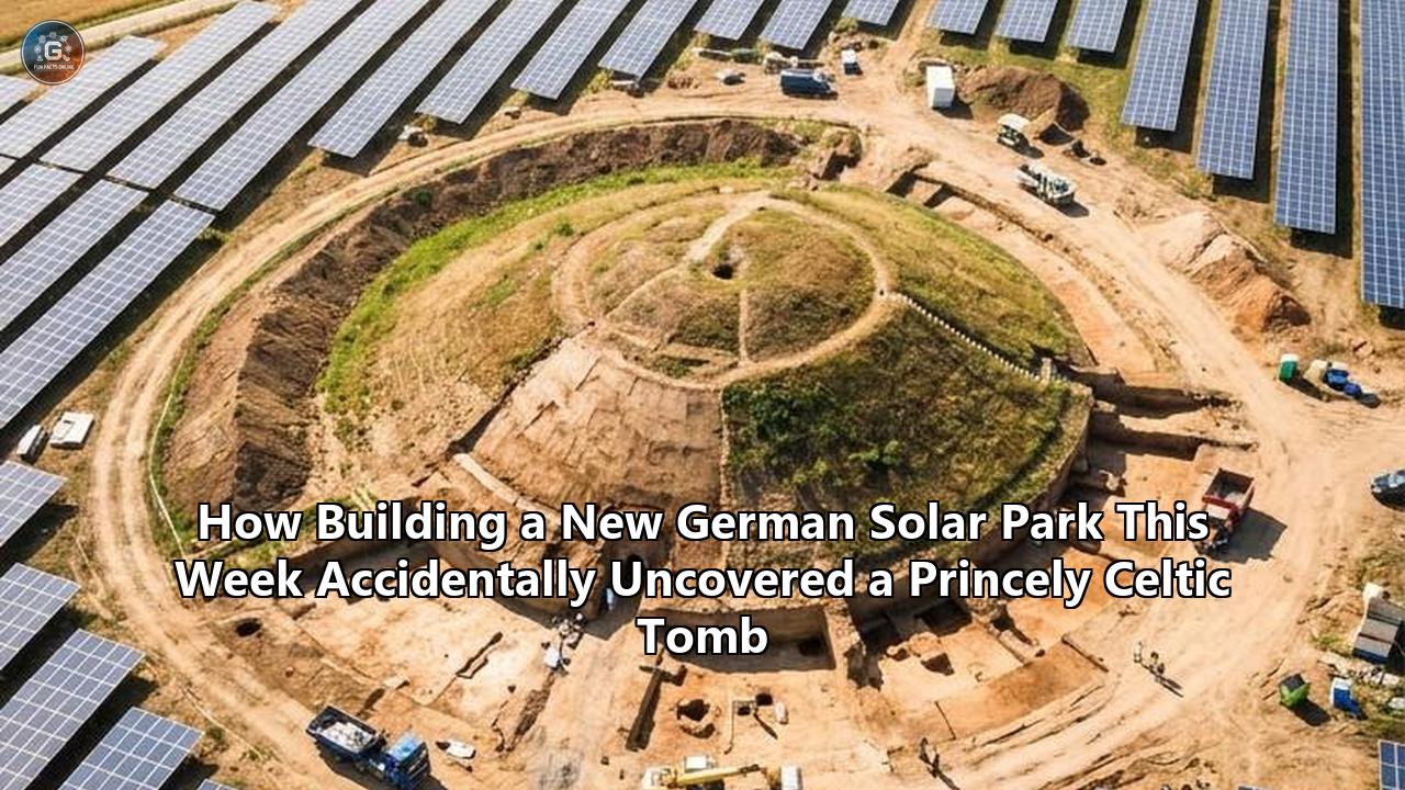
What makes this discovery uniquely modern is its origin story. The tomb was not found during a planned academic expedition, nor was it uncovered by amateur treasure hunters. Instead, it was accidentally detected during routine preparatory surveys for a commercial solar park near the town of Bad Camberg, situated in the Taunus mountain range of western Germany.
The site, positioned on a previously unused agricultural parcel directly adjacent to the busy A3 motorway, was slated to host hundreds of silicon photovoltaic panels. By law, the planned ground disturbance triggered a preemptive archaeological investigation.
Within two weeks of the first excavator bucket breaking ground, a specialized field crew from the private contracting firm SPAU GmbH uncovered a spectacular assemblage of Iron Age wealth: three solid gold rings, a complete two-wheeled war chariot, weaponry, and a luxury bronze drinking vessel imported from the Etruscan civilization in modern-day Italy.
"You only make such a find once in your archaeological career," remarked Dr. Kai Mückenberger, the district archaeologist for the Limburg-Weilburg region, during the Wiesbaden press conference.
                                [ A3 Motorway ]
______________________________________||______________________________________
                                      ||
   [ Planned Solar Park Boundary ]    ||
  +-----------------------------------||------------------------------------+
  |                                   ||                                    |
  |     (A) Processional Path         ||                                    |
  |      ========  ========           ||                                    |
  |              \\                   ||                                    |
  |               \\                  ||                                    |
  |            (B) Circular Ditch     ||                                    |
  |               /----\              ||                                    |
  |              /  (C) \             ||                                    |
  |             |  [ ]   |            ||                                    |
  |              \      /             ||                                    |
  |               \____/              ||                                    |
  |                                   ||                                    |
  +-------------------------------------------------------------------------+
    Legend:
      (A) Two parallel linear magnetic anomalies (ancient processional road).
      (B) 10-meter circular anomaly representing the eroded burial mound.
      (C) Central rectangular anomaly: the collapsed 5th-century BC tomb.
The find marks the first time a Celtic princely grave of this caliber has been discovered during construction activities for a renewable energy facility in Germany.
As Europe accelerates its transition toward green energy, the Bad Camberg discovery stands as a primary example of how strict heritage preservation laws can coexist with rapid infrastructure development, transforming a commercial utility site into a window into the Iron Age.
The Regulatory Friction: Green Energy Meets Heritage Law
The discovery near Bad Camberg highlights a growing intersection in modern European land use: the friction between the rapid deployment of renewable energy infrastructure and the preservation of deeply buried cultural heritage.
Germany’s Energiewende (energy transition) has mandated a massive expansion of ground-mounted solar installations. These installations require extensive physical footprints, often stretching across dozens of hectares of rural, agricultural, or forest land that has remained unplowed or undisturbed for centuries.
Under the Hessian Monument Protection Law (Denkmalschutzgesetz or DSchG), any major construction project that involves significant soil disturbance must undergo a multi-phase archaeological assessment before foundation piles can be driven or cable trenches dug.
Specifically, Section 19 and Section 22 of the Act govern archaeological monuments and protected excavation zones. The law operates on the internationally recognized "polluter-pays principle" (Verursacherprinzip), meaning the developer of the solar park must fund the pre-construction archaeological surveys, testing, and subsequent salvage excavations.
+------------------------------------------------------------+
|             Solar Park Planning Phase Initiated            |
+------------------------------------------------------------+
                              |
                              v
+------------------------------------------------------------+
|     Geomagnetic & Geophysical Prospektion (Default Law)     |
+------------------------------------------------------------+
                              |
         +--------------------+--------------------+
         |                                         |
         v (No Anomalies)                          v (Anomalies Detected)
+------------------+                     +------------------+
| Permit Approved  |                     | Targeted Sondage |
| Construction     |                     | (Test Trenches)  |
| Begins           |                     +------------------+
+------------------+                               |
                                                   v
                                         +------------------+
                                         | Full Salvage     |
                                         | Excavation       |
                                         | (SPAU GmbH)      |
                                         +------------------+
                                                   |
                                                   v
                                         +------------------+
                                         | Block Excavation |
                                         | (Blockbergung)   |
                                         +------------------+
                                                   |
                                                   v
                                         +------------------+
                                         | Solar Park       |
                                         | Construction     |
                                         | Resumes          |
                                         +------------------+
To prevent these heritage laws from acting as a bottleneck for critical green energy projects, the Hessian state monument authority collaborates with private sector firms.
In the case of the Bad Camberg site, the developer contracted the services of SPAU GmbH, a private rescue archaeology company based in Münzenberg. SPAU was tasked with executing the field investigations rapidly and efficiently.
Because the developers engaged with hessenARCHÄOLOGIE early in the planning phase, the entire excavation of the central burial chamber was completed in just two weeks.
This rapid turnaround ensured that the developer’s construction schedule was not significantly delayed, proving that high-resolution rescue archaeology and large-scale green energy expansion can proceed in tandem.
The Geophysical Blueprint: How Magnetometry Unlocked the Invisible
Before a single shovel of earth was turned at the Bad Camberg solar park site, there were no visible above-ground clues to indicate that a high-status Celtic warrior lay buried beneath the field.
Centuries of intensive agricultural plowing, combined with the natural erosion of the Taunus foothills, had completely flattened whatever earthen burial mound (Grabhügel) had originally covered the tomb. To the naked eye, the plot next to the A3 highway was simply a featureless, flat expanse of soil.
The breakthrough came through geomagnetic prospection. As part of the preliminary environmental impact assessment, Dr. Kai Mückenberger ordered a high-resolution magnetic field scan of the entire project area.
Geomagnetic surveying relies on highly sensitive fluxgate gradiometers. These instruments measure micro-variations in the Earth’s local magnetic field, which are caused by subsurface differences in magnetic susceptibility.
       Fluxgate Gradiometer Sensors (Towed by ATV or hand-carried)
                  |               |               |
                  o               o               o
==================|===============|===============|==================
                  v               v               v

   [ Topsoil Layer - Ploughed & Homogenized ]
   ------------------------------------------------------------------
   [ Subsoil Layer ]
                           /-------------\  <-- Organic-rich infill
                          /  Ancient      \     of circular ditch
                         /   Ditch         \    (High Magnetic Susceptibility)
                        |    Anomaly        |
                        |   [  Rectangular  | <-- Iron weapons/metallic wagon
                        |      Chamber ]    |     fittings (High magnetic dipole)
                         \                 /
                          \               /
                           \-------------/
   [ Undisturbed Natural Bedrock / Slate ]
When ancient humans dug ditches, postholes, or burial shafts, they disturbed the natural stratigraphy of the soil. The organic-rich topsoil used to refill these features contains a higher concentration of ferromagnetic minerals (such as maghemite and magnetite) than the surrounding sterile subsoil or bedrock.
Furthermore, ancient fires, decayed organic wooden structures, and buried metallic objects create strong, localized magnetic dipoles that stand out sharply against the background geological signature.
When the raw data from the Bad Camberg scan was processed, it revealed a highly distinctive layout:
- The Processional Road: Two thin, parallel linear anomalies, running straight and true, directly next to the modern roadway.
- The Enclosure: These parallel lines terminated at a large, circular magnetic anomaly measuring roughly 10 meters in diameter.
- The Core: In the exact center of this circular ditch sat a sharply defined, dark rectangular anomaly.
For an Iron Age specialist, this geometric configuration is unmistakable. It is the classic signature of an elite Celtic burial complex.
The parallel lines represent the Prozessionsstraße—the flanking ditches of a ceremonial processional pathway along which mourners once guided a funerary hearse. The circle represents the eroded ring-ditch that originally demarcated the outer boundary of a monumental earthen burial mound. The central rectangle was the magnetic shadow of the sunken wooden burial chamber itself.
"At first, I laughed and said, 'My goodness! A princely tomb!'" Mückenberger recalled. "It was meant as a lighthearted joke because the raw images looked so textbook-perfect. They resembled the famous ceremonial pathways found at Glauberg. We expected, at the very most, to find some minor traces of an ancient agricultural settlement. To find a pristine, top-tier wagon burial here seemed like pure wishful thinking."
Skeptical but intrigued, Mückenberger directed the SPAU GmbH excavation team to dig a targeted test trench (Sondage) directly over the central rectangular anomaly.
A few days later, he received a phone call from the field director. The excavator’s bucket, carefully skimming away the topsoil layer under the close supervision of an archaeologist, had exposed a cluster of oxidized iron fragments.
They were the highly corroded but recognizable remains of an ancient iron spearhead. The joke had transformed into one of the most significant archaeological discoveries in Hesse in decades.
Anatomy of the Grave: The Vanished Warlord of the Taunus
As the SPAU GmbH field team expanded their trenches to fully expose the rectangular burial chamber, they were confronted with a major preservation challenge. The soils of the Taunus mountain range are highly acidic, dominated by weathered slate, loess, and loam.
Over two and a half millennia, this aggressive soil chemistry had completely dissolved all organic materials within the tomb. The stout oak timbers that once formed the walls and ceiling of the subterranean burial chamber had decayed into dark, powdery soil stains.
More significantly, the body of the deceased had entirely vanished. Not a single bone, fragment of skull, or even the durable enamel of a tooth survived the acidic environment.
To reconstruct the identity, status, and gender of the individual buried at Bad Camberg, researchers had to rely on taphonomic analysis—the study of how materials decay and settle over time—and the spatial distribution of the surviving metal grave goods.
+---------------------------------------------------------------------+
|                                                                     |
|                       [ Burial Chamber Layout ]                      |
|                                                                     |
|   +-------------------------------------------------------------+   |
|   | (A) Weaponry                                                |   |
|   |     [Two Spearheads & Knife]                                |   |
|   |                                                             |   |
|   |                    (B) Gold Jewelry Set                     |   |
|   |                         O  <-- Neck Torc                    |   |
|   |                                                             |   |
|   |                     o       o                               |   |
|   |                Arm   \     /  Finger                        |   |
|   |                Ring   \   /   Ring                          |   |
|   |                        \ /                                  |   |
|   |                         v                                   |   |
|   |                                                             |   |
|   |  (C) Etruscan Jug           (D) Dismounted Wagon Wheels     |   |
|   |      .

At the center of the chamber, three solid gold rings were found lying in perfect anatomical alignment. These were not thin, flimsy pieces of gold leaf, but massive, expertly crafted ornaments.

* **The Torc**: A heavy, solid gold neck ring (*Halsring*), positioned at the upper end of the cluster.
* **The Armlet**: A matching solid gold arm ring (*Armring*), situated slightly lower and to the left, where the deceased’s upper arm would have rested.
* **The Finger Ring**: A smaller solid gold ring (*Fingerring*), found in the area where the hand would have been positioned.

This complete personal jewelry set is exceptionally rare. Within the state of Hesse, a matching tripartite set of gold rings has only been documented once before: at the world-famous Glauberg elite burial, located some 60 kilometers to the east in the Wetterau region.

The presence of the gold torc is of paramount importance. In Celtic iconography and burial custom, the torc was not merely a piece of personal decoration; it was a supreme symbol of sacred and secular authority, worn exclusively by the highest echelon of the ruling class—kings, priests, or legendary heroes.

Flanking the position of the vanished body were the remains of weaponry. The excavation team recovered two iron spearheads (*Lanzenspitzen*) and a small iron utility knife.

The presence of these weapons, combined with the personal gold jewelry and the monumental scale of the burial, suggests that the interred individual was a high-ranking male warrior.

He was a local elite who held sway over the regional trade routes and communities of the Taunus foothills during the transition into the Early La Tène period.

---

## The Two-Wheeled Chariot: Reconstructing Celtic Iron Age Engineering

Beyond the gold jewelry, the most spectacular feature of the Bad Camberg tomb is the inclusion of a two-wheeled wagon, or war chariot. While the wooden chassis and frame of the vehicle had completely decomposed, its high-quality metal fittings remained remarkably intact, preserved in their original depositional positions.

In the older, Hallstatt culture of the Late Bronze and Early Iron Ages (circa 800 to 450 BC), elite burials typically featured massive, four-wheeled ceremonial wagons, such as the famous vehicle found in the Hochdorf chieftain's grave in Baden-Württemberg.

However, during the transition to the La Tène period (beginning around 450 BC), Celtic military and funerary technology shifted. The elite began burying their dead with highly maneuverable, two-wheeled chariots (*Zweiradwagen*).

These fast, light vehicles were designed for warfare and ostentatious display, heavily influenced by Mediterranean chariot designs encountered through trade and mercenary contact.
[ Cross-Section of Reconstructed Chariot Wheel ]
Iron Tire Fitting (Radreifen)
/===============================\
|| ||
|| Wooden Felloe ||
|| (Decayed) ||
|| || ||
|| Wooden Spoke ||
|| (Decayed) ||
|| || ||
|| +------------+ ||
|| | | ||
||====| Bronze Hub |==== || <-- Non-ferrous Hubcap
|| | Fitting | || (Radnabenbeschlag)
|| +------------+ ||
|| || ||
|| Axle Sleeve Fitting || <-- Axle Cap (Achskappe)
\===============================/
The SPAU GmbH archaeologists uncovered several components of this vehicle:

* **The Wheel Rims (*Radreifen*)**: The most prominent wagon features were two massive iron bands, measuring approximately 1.20 meters in diameter. These bands were the iron "tires" that had been shrunk-fit onto wooden spoked wheels to protect the running surfaces from wear and tear. The wheels had been deliberately detached from the vehicle's body during the funeral and placed upright against one of the wooden walls of the burial chamber.
* **The Hubcaps (*Radnabenbeschläge*)**: At the center of the wheels lay large, circular hubcaps made of non-ferrous metal, likely a high-quality copper alloy or bronze. These fittings were highly decorated, featuring intricate geometric designs characteristic of early Celtic art.
* **The Axle Caps (*Achskappen*)**: The ends of the wooden axle tree had been capped with sleeve-like bronze fittings to secure the wheels in place.

"When these fittings were new, they would have gleamed with a brilliant, reddish-golden luster," explained Dr. Kai Mückenberger. "As the chariot rolled through the settlements of the Taunus, the spinning bronze hubcaps would have caught the sunlight, presenting an incredible display of wealth and technological mastery to anyone watching."

Remarkably, one of the axle sleeves still contained mineralized remnants of the original wooden axle tree.

As the iron and bronze of the fittings corroded over the millennia, the metal salts permeated the adjacent wood cells. This process replaced the organic cellulose with durable metallic oxides, preserving the cellular structure of the wood and allowing modern archaeobotanists to identify the specific tree species used by Celtic wheelwrights.

The Bad Camberg find is one of only a handful of Celtic wagon burials ever discovered in Hesse.

"Only about three comparable graves are known in our state," noted State Archaeologist Prof. Dr. Udo Recker. "And none of them come close to matching the extraordinary quality, preservation, and artistic execution of the metalwork recovered from this new site."

---

## The Mediterranean Connection: Tracing the Etruscan Jug

Among the prestige goods recovered from the Bad Camberg grave, one object stands out as a testament to the vast, continent-spanning trade networks of the 5th century BC: an imported Etruscan bronze jug, or *Schnabelkanne* (beak-spouted jug).

The Etruscans were an advanced, seafaring civilization that flourished in central Italy, primarily in the region of modern-day Tuscany, prior to the rise of the Roman Republic.

They were renowned for their metallurgy, maritime commerce, and complex religious rituals. In the 5th century BC, Etruscan workshop centers manufactured bronze vessels of exceptional quality, which were highly sought after by elite consumers across Europe.
[ Etruscan Beak-Spouted Jug (Schnabelkanne) ]
( ) <-- Spout (Schnabel)
/ \
/ \_____ <-- Elegant handle
| ____/ with zoomorphic attachment
| |
| |
\ /
| |
/ \
/ \
| | <-- Rounded bronze body
| | (Sought-after Mediterranean import)
\_______/
The presence of this jug in the Taunus Mountains—hundreds of kilometers north of the Alps—reveals a well-organized, high-value trade route.

To acquire such an object, the Bad Camberg prince or his agents had to engage with a network of intermediaries who transported luxury goods through Alpine passes, down the Rhine river corridor, and into the German highlands.

In return for these Mediterranean luxury imports, the Celtic elites traded raw materials that were highly valued in the south:
* **Iron**: The Taunus and neighboring regions possess rich, easily accessible deposits of iron ore, which the Celts mined and smelted with high efficiency.
* **Salt**: Often referred to as "white gold," salt was essential for food preservation and livestock management, mined heavily in central German deposits.
* **Furs and Forest Products**: High-quality animal pelts and timber from the dense Central European forests.
* **Human Cargo**: Mercenaries or enslaved individuals, who were integrated into the Mediterranean economy.

The Etruscan jug was not merely a passive display of wealth; it played an active role in the social and political life of the Celtic court.

The Celts did not possess a written language, and their society was organized into fluid, highly competitive tribal confederations. To maintain power, a chieftain or warlord had to continuously secure the loyalty of his vassals, warriors, and neighboring allies.

This loyalty was cemented through the ritual of the feast. The Etruscan jug was the centerpiece of a highly formalized banqueting culture, adapted from Mediterranean drinking customs.

During these grand feasts, the prince would use the imported vessel to serve mead, local herbal beers, or highly prized imported Italian wine. By distributing these exotic, prestigious beverages, the host reinforced his social superiority, bound his warriors to him through sacred oaths of hospitality, and forged political alliances with visiting dignitaries.

The jug found at Bad Camberg is typologically similar to the famous specimens recovered from the elite tombs of Glauberg.

Its inclusion in this grave confirms that the Celtic communities of the Taunus were not isolated forest dwellers, but active, highly integrated participants in a globalized Iron Age economy that linked the cold forests of Germany to the warm shores of the Mediterranean Sea.

---

## Science in the Lab: The Micro-Excavation of Blockbergung

When the SPAU GmbH excavation team realized the immense significance of the Bad Camberg grave, they faced a critical decision. Excavating highly corroded, fragile metal artifacts directly in the open field is a risky endeavor.

Changes in humidity, exposure to direct sunlight, and physical handling can cause ancient iron and bronze to disintegrate within hours of being exposed to the air.

To preserve the artifacts and their exact spatial relationships, the team employed a specialized technique known as *Blockbergung* (block excavation).
[ The Process of Blockbergung (Block Excavation) ]
- ISOLATION: 2. REINFORCEMENT:
Excavators dig trench around Apply plaster bandages/polyurethane
the archaeological feature. foam to stabilize the soil block.
| Soil Block | +======================+
| +--------+ | | /================\ |
_____| | Artifact| |_____ _____| | Soil & Artifact| |_____
| +--------+ | | \================/ |
\______________/ +======================+
- UNDER-CUTTING: 4. TRANSPORT & LAB ANALYSIS:
Slide steel plates beneath Lift block with heavy machinery.
the stabilized block. Transport to LEIZA CT Facility.
+======================+ [ LEIZA IMPALA CT ]
| /================\ | |||
_____| | Soil & Artifact| |_____ +--------------+
======|==\================/==|====== | [3D-Scan] |
+======================+ +--------------+
Rather than trying to free the gold rings, the Etruscan jug, or the chariot fittings from the surrounding earth, the archaeologists isolated large blocks of soil containing the finds.

They carefully dug narrow trenches around the features, encased the resulting earthen columns in plaster bandages and stabilizing polyurethane foam, and slid steel plates beneath them. Once secured, these heavy blocks of earth—some weighing hundreds of kilograms—were lifted intact using cranes and flatbed trucks.

These soil blocks were first transported to the conservation workshops of *hessenARCHÄOLOGIE* in Wiesbaden, before being transferred to the Leibniz Research Institute for Archaeology (LEIZA) in Mainz, which boasts some of the most advanced archaeological imaging facilities in Europe.

Through a long-standing scientific partnership between the state of Hesse and LEIZA, the Bad Camberg soil blocks were analyzed using the IMPALA platform (Imaging Platform at LEIZA).

At the heart of this platform is an industrial 3D computed tomography (CT) scanner, the Phoenix V|tome|x L450 manufactured by Waygate Technologies. This high-energy X-ray system is capable of scanning large, dense objects measuring up to 2.5 meters in height and 1 meter in diameter, weighing up to 100 kilograms.

The CT scanner operates by rotating the soil block 360 degrees within a heavily shielded lead chamber, exposing it to a highly penetrative X-ray beam.

A digital detector captures thousands of two-dimensional radiograph projection images from every angle. Advanced reconstruction software then compiles these projections into a high-resolution, three-dimensional digital volume.
[ 3D Industrial Computed Tomography (CT) Scanning ]
X-Ray Source Soil Block Digital Detector
+------------+ +----------+ +--------------+
| | | | -o-| | | | | | | | | |
| (===) ===|============>| | -o-| |============>| | | | | | | |
| | | | -o-| | | | | | | | | |
+------------+ +----------+ +--------------+
(Rotating on
turntable)
|
v
[ IMPALA Processing Engine ]
|
v
[ 3D High-Res Digital Volume ]
(100-micrometer resolution)
The resulting 3D scans provide a resolution of up to 100 micrometers, allowing conservators to perform a virtual excavation of the block before a single scalpel touches the soil.

"With the 3D-CT, we can look straight through the dense clay and loam of the Taunus," explained Dr. Ivan Calandra, the head of the imaging platform at LEIZA. "We can precisely map the spatial location, thickness, and state of preservation of every metal artifact hidden inside. This allows us to plan our physical micro-excavation with surgical precision, preventing accidental damage to fragile pieces."

The results of these scans have been remarkable. The CT data revealed that the soil blocks contain far more than just the large, highly visible items like the gold rings and chariot rims.

The digital images have exposed a dense concentration of smaller, hidden grave offerings:
* **Bronze Decorative Pins**: Intricate fibulae used to fasten the clothing of the deceased.
* **Glass and Amber Beads**: Scattered remnants of elaborate necklaces or embroidery on organic textiles that have long since vanished.
* **Organic Pseudomorphs**: Shadows of wood grain, leather straps, and textile fibers that have been mineralized by the corrosion of adjacent iron objects.

In total, the imaging scans have mapped over 100 individual objects preserved within the soil blocks.

This non-destructive analysis ensures that the physical excavation of the blocks, which is currently underway in the laboratories of Wiesbaden and Mainz, can proceed with an unprecedented level of scientific control, preserving microscopic details that would have been lost using traditional field methods.

---

## Geopolitics of the Iron Age Taunus: Redefining the Hunsrück-Eifel Culture

The discovery of the Bad Camberg princely tomb is not just a triumph of salvage archaeology and modern laboratory science; it is a major geopolitical revelation that forces a reassessment of the socio-political landscape of Iron Age Germany.

To understand the historical importance of the find, one must look at the cultural map of 5th-century BC Europe.

The region of modern-day Hesse was a complex borderland characterized by two overlapping archaeological cultures:
* **The La Tène Culture of the Wetterau**: Centered on major hillfort complexes like Glauberg, this culture is famous for its elaborate stone sculptures, highly decorated elite burials, and a social hierarchy dominated by "princes" who wore golden earrings.
* **The Hunsrück-Eifel Culture (HEK II)**: Centered primarily west of the Rhine River, in the rugged highlands of modern-day Rhineland-Palatinate, Luxembourg, and the Saarland, this culture is characterized by its distinctive pottery, a lack of massive monumental stone sculpture, and a high frequency of rare, two-wheeled wagon burials.
[ Cultural Geography - 5th Century BC ]
Hunsrück-Eifel Culture (HEK II) La Tène Wetterau Culture
================================= ===========================
- Geographic Core: West of Rhine - Geographic Core: Wetterau
- Funerary Rite: Two-Wheeled Wagon - Funerary Rite: "Gold Earring"
Burials (Chariots) Burials, Mounds with Statues
- High-quality bronze imports - Rich gold personal jewelry,
from Etruria (Schnabelkannen) sculpted stone monuments
\ /
\ /
v v
[ The Taunus Intersection: Bad Camberg ]
- Structurally Hunsrück-Eifel (Wagon + Etruscan Jug)
- Richly endowed with Wetterau-style Gold Jewelry Set
- Proves the existence of a wealthy local elite
controlling key trade routes (modern A3 corridor)
For decades, the Taunus mountain range was viewed by historians as a peripheral, sparsely populated buffer zone between these two powerful cultural spheres.

While researchers hypothesized that local elites must have existed in the Taunus to control the flow of goods between the Wetterau and the Rhineland, no physical evidence of a first-class elite burial had ever been found in the region.

The Bad Camberg tomb changes this picture.

The grave exhibits a fascinating hybrid of both cultural traditions:
* **The Wagon Burial Rite**: The inclusion of a two-wheeled chariot is a classic Hunsrück-Eifel cultural trait, aligning the Bad Camberg prince with the aristocratic dynasties of the Rhine-Mosel-Eifel network.
* **The Gold Ring Set**: The complete set of solid gold neck, arm, and finger rings is a hallmark of the high-status La Tène elites of the Wetterau, closely echoing the jewelry found on the Glauberg prince.

This hybridity suggest that the Bad Camberg prince was a powerful regional actor who leveraged his geographic position to bridge the two cultural zones.

His tomb was located along a natural, low-altitude pass through the Taunus Mountains—a route that has been used for millennia and is followed today by the modern A3 motorway and the high-speed ICE railway line.
[ Regional Trade and Control Corridors ]
Wetterau Basin Limburg Basin
(Rich Agricultural Land) (Mineral Resources / Iron)
\ /
\ /
v v
+---------------------------------+
| Taunus Mountain Pass Corridor |
| |
| === [ BAD CAMBERG ] === | <-- Elite stronghold/toll gate
| |
+---------------------------------+
|
v
Rhine-Main Hub
(Access to Alpine Trade Routes)
By controlling this strategic mountain pass, the local elite of Bad Camberg could regulate and tax the movement of goods—such as iron from the Limburg basin, salt from the Wetterau, and luxury imports from the Mediterranean—traveling between the Rhine-Main lowlands and the northern valleys.

The extraordinary wealth found in this tomb—the gold, the bronze, the advanced chariot—was the direct product of this strategic geographic monopoly.

"With the early La Tène-era princely grave of Bad Camberg, we can now prove what was previously only a hypothesized presence of a highly organized, wealthy local Celtic elite in this region," stated State Archaeologist Prof. Dr. Udo Recker. "This tomb is a key piece of the puzzle, showing how local leaders in the Taunus accumulated immense wealth by acting as gatekeepers and facilitators of interregional trade."

---

## Comparative Analysis: The Bad Camberg Prince vs. The Glauberg Prince

To fully appreciate the European significance of the Bad Camberg Celtic tomb discovery, it is essential to compare it to the most famous Iron Age discovery in Hesse: the "Keltenfürst vom Glauberg" (Glauberg Prince), unearthed in 1996.

| Feature | The Glauberg Prince (Discovered 1996) | The Bad Camberg Prince (Discovered 2026) |
| :--- | :--- | :--- |
| **Date of Tomb** | Circa 450–400 BC (Early La Tène) | Circa 450–400 BC (Early La Tène) |
| **Geographic Location** | Wetteraukreis, Hesse (Lowland Plain) | Limburg-Weilburg, Hesse (Taunus Mountains) |
| **Archaeological Culture** | Classic Early La Tène (Wetterau group) | Hunsrück-Eifel Culture (HEK II) / La Tène Hybrid |
| **Funerary Vehicle** | None (No wagon or chariot in the primary elite grave) | Complete two-wheeled chariot (Wagon burial) |
| **Personal Gold Jewelry** | Complete set: Neck torc, arm ring, gold earrings | Complete set: Solid gold neck torc, arm ring, finger ring |
| **Imported Luxury Goods** | Etruscan bronze jug (*Schnabelkanne*) | Etruscan bronze jug (*Schnabelkanne*) |
| **Weaponry** | Sword, iron spearheads, shield, arrowheads | Iron spearheads, utility knife |
| **Above-Ground Monuments** | Monumental earthen mound, life-size sandstone statue | Monumental earthen mound (Eroded/flattened by agriculture) |
| **Socio-Political Role** | Ruler of a major territorial hillfort (*Fürstensitz*) | Warlord controlling a strategic mountain pass/trade corridor |

While the Glauberg prince was buried with a wealth of personal ornaments and later commemorated with a life-size stone statue, his grave lacked a chariot.

The Bad Camberg prince, by contrast, was buried with his vehicle—a practice that reflects a different ideological focus.

The inclusion of the chariot emphasizes mobility, martial prowess, and a close cultural connection to the militarized societies of the Rhine-Mosel region.

The artistic quality of the Bad Camberg chariot fittings and the imported Etruscan jug matches, and in some respects surpasses, the craftsmanship of the Glauberg finds.

This high level of craftsmanship demonstrates that the elite of the Taunus foothills were equal in status, wealth, and diplomatic reach to the well-documented rulers of the fertile Wetterau lowlands.

---

## Future Milestones: What Happens Next?

The public presentation in the Biebrich Palace was only the opening chapter of a scientific and conservation project that will span several years.

Because the excavation team chose to lift the grave contents using the *Blockbergung* method, the majority of the artifacts are still physically encased in their protective soil matrix.
[ Five-Year Post-Excavation Roadmap ]
Year 1: Non-Destructive Mapping & Micro-Excavation
+--------------------------------------------------------------------------+
| - Complete high-res industrial CT scans at LEIZA IMPALA facility. |
| - Begin physical micro-excavation of soil blocks under microscope. |
| - Recover delicate glass, amber, and organic textile pseudomorphs. |
+--------------------------------------------------------------------------+
|
v
Year 2-3: Metallurgical & Chemical Analysis
+--------------------------------------------------------------------------+
| - Perform lead and copper isotope fingerprinting on Etruscan bronze jug. |
| - Conduct trace-element analysis on gold torc to trace gold source. |
| - Analyze organic residues (lipids, tartaric acid) inside Etruscan jug. |
+--------------------------------------------------------------------------+
|
v
Year 4: Stabilization & Conservation
+--------------------------------------------------------------------------+
| - Apply long-term chemical stabilization to fragile iron chariot rims. |
| - Prevent "bronze disease" on Etruscan jug using chemical inhibitors. |
| - Restore and reconstruct wood-and-metal assemblies of chariot hubs. |
+--------------------------------------------------------------------------+
|
v
Year 5: Public Exhibition & Integration
+--------------------------------------------------------------------------+
| - Develop permanent exhibition at Keltenwelt am Glauberg museum. |
| - Integrate find data into European Iron Age trade route database. |
| - Solar park operational; onsite historical information boards installed. |
+--------------------------------------------------------------------------+
The Analytical Phase
The immediate next step involves finishing the detailed micro-excavation of these soil blocks in the conservation laboratories of hessenARCHÄOLOGIE in Wiesbaden.
Using the 3D-CT scans as a roadmap, conservators will use micro-scalpels, air-abrasive systems, and dental tools to slowly remove the soil, exposing the delicate artifacts without causing damage.
Once freed from the earth, the objects will undergo a battery of advanced scientific tests:
- Isotopic Analysis: Lead isotope testing will be conducted on the Etruscan bronze jug to determine the exact mine in Italy where the copper was extracted. Similarly, trace-element analysis of the gold rings will help pinpoint the origin of the gold, whether from local river sediments or imports from Bohemia or France.
- Organic Residue Analysis (Gas Chromatography-Mass Spectrometry): The interior of the Etruscan bronze jug will be scraped for microscopic organic residues. By identifying ancient lipids, tartaric acid (a marker for grape wine), and herbal markers, chemists can reconstruct the exact beverage served by the prince—whether it was imported Mediterranean wine, local mead, or beer flavored with pine resin and botanicals.
- Metallurgical Conservation: The iron chariot rims and fittings are highly vulnerable to rapid decay once exposed to atmospheric moisture. They must undergo long-term desalination and stabilization baths to prevent "bronze disease" and structural crumbling.
The Public and Local Legacy
While the long-term conservation work continues in Wiesbaden and Mainz, the local community of Bad Camberg is already looking toward the future.
Daniel Rühl, the Mayor of Bad Camberg, expressed pride in the discovery and emphasized the importance of keeping the find connected to the local region.
"This discovery has put Bad Camberg on the European archaeological map," Rühl said. "While we understand that these priceless artifacts must be conserved in specialized state labs, we are working closely with the state of Hesse to ensure that our citizens and visitors can experience this heritage. We plan to install educational displays and a reconstruction of the tomb near the site of the solar park, allowing the public to understand the deep history of the landscape they are walking through."
State Secretary Christoph Degen indicated that once the conservation and scientific publication phases are complete, the spectacular gold jewelry, the Etruscan jug, and the reconstructed chariot wheels will likely be displayed in a special exhibition at the Keltenwelt am Glauberg museum.
This museum, built directly adjacent to the Glauberg burial mound, serves as the central research and exhibition hub for Iron Age history in Hesse, making it the ideal venue to present the newly discovered "Prince of the Taunus" to a global audience.
As the solar park near Bad Camberg is built and begins feeding clean, renewable electricity into the German grid, it will stand as a model for modern development.
The project has demonstrated that the transition to a sustainable future does not require the erasure of the past. Through smart planning, advanced geophysics, and rapid, professional rescue archaeology, Germany has preserved a piece of its ancient heritage, illuminating the lives of the Celtic elites who shaped the region two and a half millennia ago.
Reference:
- https://www.bad-camberg.de/rathaus-politik/aktuelles/aktuelles-aus-bad-camberg/pressearchiv-2026/archaeologischer-fund-fuerstengrab/
- https://www.upday.com/de/news/2500-jahre-altes-furstengrab-bauarbeiter-finden-gold-etruskische-kanne-und-prunkwagen/xl9gx42
- https://news.inbox.eu/150d1f4-archaeological-sensation-iron-age-celtic-grave-discovered-in-hesse?language=en
- https://www.heritagedaily.com/2026/06/celtic-princely-tomb-discovered-near-bad-camberg-in-major-archaeological-breakthrough/158300
- https://www.reddit.com/r/Archaeology/comments/1u01bti/exceptional_celtic_elite_gave_f%C3%BCrstengrab/
- https://www.landesarchaeologien.de/aktuelles/newsdetail/der-keltenfuerst-des-taunus
- http://www.thehistoryblog.com/archives/date/2026/06/09
- https://www.goodnewsnetwork.org/an-almost-incomparable-princely-tomb-of-ancient-celtic-noble-found-in-germany/
- https://wissenschaft.hessen.de/presse/hessenarchaeologie-praesentiert-unbekanntes-eisenzeitliches-fuerstengrab
- https://www.wiesbaden.de/en/leben-in-wiesbaden/wohnen-bauen/bauaufsicht/denkmalschutz/solaranlagen-denkmalgeschuetzte-gebaeude
- https://www.kulturgutschutz-deutschland.de/SharedDocs/ExterneLinks/EN/Gesetze_en/DSchG_Laender/HE_DSchG.pdf?__blob=publicationFile
- https://spau-gmbh.de/referenzen/
- http://www.thehistoryblog.com/archives/date/2026/06/09
- https://spau-gmbh.de/member/stefanie-matulat/
- https://inkorr.com/en/u-nimeccini-pid-budivnictvom-ses-znajsli-keltske-knazivske-pohovanna-v-stolitta-do-ne-331060
- https://www.smithsonianmag.com/smart-news/construction-in-germany-revealed-the-princely-grave-of-a-celtic-warrior-who-was-buried-with-weapons-and-a-two-wheeled-wagon-180988952/
- https://www.spektrum.de/news/hessen-wagenbestattung-eines-keltenfuersten-entdeckt/2328410
- https://www.welt.de/regionales/hessen/article6a26a116f1ea924ca06cc3ec/keltenfuersten-grab-im-taunus-liefert-spektakulaere-funde.html
- https://www.archaeologie-online.de/nachrichten/der-keltenfuerst-des-taunus-6666/
- https://www.indexbox.io/blog/celtic-princely-grave-discovered-during-solar-park-construction-in-bad-camberg/
- https://www.herder.de/wbg-magazine/aktuelles/2026/neues-keltisches-fuerstengrab-bei-bad-camberg-entdeckt/
- https://www.geschichtsforum.de/thema/das-fruehkeltische-prunkgrab-von-bad-camberg-im-hintertaunus-landkreis-limburg-weilburg.69871/
- https://www.turkiyetoday.com/culture/rare-2000-year-old-princely-celtic-tomb-found-in-germany-3221641
- https://voi.id/en/lifestyle/579996
- https://www.goodnewsnetwork.org/an-almost-incomparable-princely-tomb-of-ancient-celtic-noble-found-in-germany/
- https://www.museumfuernaturkunde.berlin/en/erkunden/versteinerte-vielfalt/
- https://www.leiza.de/aktuelles/nachricht/blick-ins-innere-eines-keltischen-fuerstengrabs
- https://rheinmainkultur.de/internationales-forschungsnetzwerk-untersucht-in-mainz-mit-leiza-super-ct-gebrauchsspuren-an-16-mio-jahre-alten-werkzeugen/
- https://www.herder.de/wbg-magazine/aktuelles/2023/16-millionen-jahre-alte-gebrauchsspuren-an-steinwerkzeugen/
- https://idw-online.de/de/news825087
- https://www.geschichtsforum.de/thema/das-fruehkeltische-prunkgrab-von-bad-camberg-im-hintertaunus-landkreis-limburg-weilburg.69871/#post-939085
- https://wissenschaft.hessen.de/presse/hessenarchaeologie-praesentiert-unbekanntes-eisenzeitliches-fuerstengrab