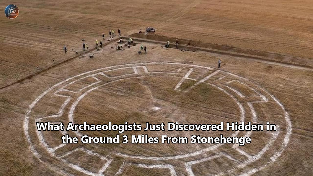
A 5,000-year-old wooden monument aligned precisely with the summer and winter solstices has been discovered just three miles (five kilometers) east of Stonehenge, in the village of Bulford, Wiltshire. Revealed by researchers from Wessex Archaeology on Thursday, June 18, 2026, the discovery provides what experts describe as a physical "prototype" for the iconic solar alignments that would later be immortalized in stone.
The announcement, timed just days before thousands of modern-day revelers gather at Stonehenge to witness the 2026 summer solstice sunrise, has redrawn the map of the prehistoric Salisbury Plain. Radiocarbon dating of food residues and charcoal at the Bulford site places the monument’s construction at approximately 2950 B.C.—coinciding with the very earliest earthwork phase of Stonehenge, but predating the raising of its famous stone trilithons by some 500 years.
This newly identified structure consisted of two massive wooden posts set 120 meters (394 feet) apart, standing on a hillside overlooking the Nine Mile River. Long after the wood rotted away, the remaining postholes have yielded a wealth of Neolithic artifacts, including unique pottery, tools, and a rare disc-shaped flint knife that may have symbolized the sun itself.
"What we've discovered at Bulford is 500 years earlier than the famous stones we know so well," said Dr. Phil Harding, the veteran archaeologist who led the excavations for Wessex Archaeology. Harding, a familiar face to British audiences from his decades on Channel 4’s Time Team, described the find as the ultimate highlight of his career. "In a few days' time, Stonehenge will be filled with people celebrating the midsummer solstice. But what few will realize is that 5,000 years ago on a nearby hillside, people were doing the exact same thing—revering and celebrating the sunrise."
The Logic of the Alignment: Skyscape Archaeology and the 2950 B.C. Sky
To confirm that the two postholes represented a deliberate astronomical alignment rather than a coincidence, Wessex Archaeology collaborated with Dr. Fabio Silva, a leading "skyscape archaeologist" and expert in ancient astronomical mapping. Because the Earth's 23.5-degree axial tilt undergoes a slow axial precession over thousands of years, the exact positions of sunrise and sunset on the solstices shift across the centuries. To the modern eye, the alignment might appear slightly off, but to a Neolithic observer in 2950 B.C., it was precise.
Silva reconstructed the night skies and horizon of Salisbury Plain as they would have appeared exactly five millennia ago. His digital models proved that the two wooden posts, standing between three and four meters high, lined up with the midsummer sunrise at one end and the midwinter sunset at the other, within a single degree of accuracy.
The layout functioned essentially like an enormous gunsight. An observer standing at the southwestern post and looking northeastward toward the second post would have seen the first rays of the summer solstice sun break the horizon directly behind the distant wooden pillar. Conversely, looking southwestward along the same line during the winter solstice would frame the setting sun.
       [ Winter Solstice Sunset ]
                 \
                  \
                   \  (Line of sight: 120 meters)
                    \
                     \
             [ Summer Solstice Sunrise ]
"Although the positions of the sun, moon, and stars do not appear to radically change within a single human lifetime, over the centuries they do," Silva explained. "By reconstructing the sky of 2950 B.C., we showed that the alignment is exactly right."
For Matt Leivers, Senior Research Manager at Wessex Archaeology, the precision of this alignment is proof of a sophisticated, shared regional belief system. "This is the earliest known solar alignment in the Stonehenge landscape," Leivers noted. "They developed an interest in marking the solstice with precision, and we are seeing the religion of the Stone Age made manifest in the ground."
The "Aha!" Moment of a Lifetime: Phil Harding's Pencil and Ruler
The story of how this prototype was identified is a testament to the meticulous, sometimes agonizingly slow nature of modern archaeology. The physical excavation of the Bulford site actually took place between 2015 and 2017. It was carried out as a rapid "rescue archaeology" project ahead of a major housing development by the U.K. Ministry of Defence (MoD).
At the time, the site yielded a complex jumble of features: Saxon graves, World War I training trenches, and dozens of prehistoric pits filled with dark earth, pottery shards, and animal bones. Because of the sheer volume of material recovered across the 30-acre plot, it took nearly a decade of post-excavation analysis, radiocarbon dating, and stratigraphic mapping to piece the architectural puzzle together.
For years, the two critical postholes simply looked like unusually large, isolated features amidst a dense cluster of 48 Neolithic rubbish pits. The breakthrough came when Phil Harding was reviewing the digitized site plans at his drawing board.
"I did what archaeologists always do—I got my pencil and ruler," Harding said. "I noticed these two very large, anomalous postholes that stood far apart from the rest of the pits. When I joined them up with a straight line, I realized that the line was about 50 degrees off direct north. That is pretty much the exact line of the midsummer sunrise on Salisbury Plain. I got really, really excited."
Harding’s low-tech observation, later verified by Dr. Silva's high-tech astronomical algorithms, transformed what had been recorded as a standard prehistoric occupation site into one of the most significant archaeological developments in Wiltshire in decades.
Anatomy of the Bulford Site: Excavating the Sacred Encampment
The 30-acre (13-hectare) plot overlooking the modern-day village of Bulford sits on a chalk ridge. While the wooden posts themselves have long since rotted, the subterranean voids they left behind preserved a detailed blueprint of how they were engineered and used.
The Solstitial Postholes
The two primary postholes stood 120 meters apart. To anchor timber pillars capable of weathering the high winds of the Salisbury Plain, the Neolithic builders excavated tapered pits approximately 30 inches (75 centimeters) deep. The pits measured roughly four feet across at the surface, narrowing to 1.6 feet at the bottom.
               4 feet (Top)
       \_______________________/
        \                     /
         \   [Chalk Packing] /
          \                 /  30 inches deep
           \               /
            \             /
             \___________/
             1.6 feet (Base)
Instead of filling these holes with soil and domestic waste, the builders packed them tightly with clean, crushed white chalk rubble. This served as a heavy, structural concrete-like packing designed to hold the heavy ash wood posts upright. Charcoal analysis of residues within one of the pits confirmed the wood species as ash (Fraxinus excelsior).
"Ash grows like a weed on these chalk plains," Harding noted. "They would have had plenty to choose from, and it is a tree that grows tall, straight, and strong—perfect for setting up a solar alignment like this."
The 48 Neolithic Pits
Surrounding and aligning with the two main postholes were 48 smaller pits, each averaging 50 centimeters deep and 60 centimeters wide. Radiocarbon dating of short-lived organic materials within these pits—such as animal bone fats and charcoal—yielded a remarkably tight cluster of dates centered around 2950 B.C.. This indicates that the entire complex was utilized over a very brief period, perhaps just a single decade.
Rather than acting as general refuse dumps, these pits contained highly structured, intentional deposits of prehistoric wealth:
- Grooved-Ware Pottery: The pits yielded hundreds of delicate, thin-walled pottery shards decorated with intricate horizontal bands, slashes, and raised cordons.
- Worked Flints and Tools: Numerous high-quality flint scrapers, blades, and waste flakes were found, alongside red deer antler picks which would have been used to dig the hard chalk ground.
- Animal Bones: Substantial quantities of pig and cattle bones were excavated. Many of the bones bore butchery marks and showed signs of roasting, indicating that large-scale, seasonal feasting took place at the site.
The "Sun Disc" Knife
Perhaps the most evocative artifact recovered from the excavations was a rare, beautifully crafted discoidal flint knife. Found deposited vertically within one of the pits directly aligned with the solar axis, the knife is a masterpiece of late Stone Age craftsmanship. It is circular, ground thin, and polished to a smooth finish.
"It's a beautiful piece of flint-working," Harding said, admiring the tool's delicate, translucent edges. "The workmanship that has gone into it is extraordinary. The fact that it is completely circular and was placed so deliberately in an upright position suggests it may well have been a symbolic representation of the sun's disc itself."
Evolution of a Sacred Plain: Contextualizing Archaeological Discoveries near Stonehenge
The discovery at Bulford adds a vital, missing link to the long history of archaeological discoveries near Stonehenge. For over a century, Salisbury Plain has been recognized as one of the densest complexes of Neolithic and Bronze Age monumentality in Europe. However, the relationship between Stonehenge and its surrounding landscape has often been viewed as a chronological puzzle.
       CHRONOLOGY OF THE STONEHENGE SACRED LANDSCAPE

       3500 B.C. ─── [ Stonehenge Cursus Built ]
                           │
       3100 B.C. ─── [ Blick Mead Spring Site Active ]
                           │
       3000 B.C. ─── [ Stonehenge Phase I (Earthworks & Aubrey Holes) ]
             *       [ BULFORD SOLAR ALIGNMENT ERECTED (2950 B.C.) ]
                           │
       2600 B.C. ─── [ Durrington Walls & Woodhenge Built ]
                           │
       2500 B.C. ─── [ Stonehenge Phase II (Sarsen Stones Raised) ]
                           │
       2300 B.C. ─── [ Amesbury Archer Burial ]
When the earliest earthworks of Stonehenge—a simple circular ditch and bank containing the 56 chalk-filled pits known as the Aubrey Holes—were constructed around 3000 B.C., there was no stone circle. Instead, the Aubrey Holes likely held a series of smaller Welsh bluestones or heavy timber posts.
The Bulford monument was built during this exact window. Its existence demonstrates that 500 years before the great 40-ton sarsen stones were dragged from the Marlborough Downs to form the familiar lintelled circle of Stonehenge, communities on Salisbury Plain were already obsessively tracking the solar cycle using simpler, organic materials.
This find fits neatly into a broader regional pattern of timber monuments. Other significant archaeological discoveries near Stonehenge have highlighted the widespread use of wood in prehistoric ritual:
- Woodhenge: Located just two miles northeast of Stonehenge, this complex of six concentric rings of timber postholes was built slightly later, around 2500 B.C., and was also aligned toward the summer solstice sunrise.
- Durrington Walls: A massive henge enclosure containing the remains of a vast Neolithic village where the builders of Stonehenge's stone phases are believed to have lived and feasted on pork and beef.
- Blick Mead: A year-round spring site just a mile from Stonehenge that has revealed continuous human occupation dating back to the Mesolithic era (8000 B.C.), proving that the area was a sacred draw long before any monuments were erected.
The Bulford discovery confirms that Salisbury Plain was not an empty space populated by a single, isolated monument. It was a bustling, interconnected sacred geography where communities moved between different ceremonial hubs depending on the season.
The Scholarly Debate: Is Two Points a Pattern?
While the Wessex Archaeology team is highly confident in their findings, the announcement has sparked lively debate among British prehistorians. Proving an intentional astronomical alignment from only two postholes is notoriously difficult in landscape archaeology, where ancient pits are common and lines can theoretically be drawn to connect almost any two points on a map.
Dr. Jim Leary, a senior lecturer in archaeology at the University of York, expressed healthy academic skepticism regarding the "prototype" label.
"Two postholes don't make a particularly convincing alignment on their own," Leary cautioned. "Salisbury Plain is absolutely riddled with Neolithic pits and postholes. When you have dozens of features across a multi-hectare site, the laws of probability dictate that some of them will inevitably line up with astronomical events like the solstice. We must be cautious about declaring every pair of holes a prehistoric observatory."
In response, Harding and Leivers point to the unique physical characteristics of the Bulford pits as proof of their special status. They argue that the two solstitial postholes are structurally distinct from the 48 domestic pits surrounding them.
"These were not rubbish pits," Leivers countered. "They were deeper, carefully tapered, and lacked any domestic debris. Instead, they were packed with clean chalk specifically to anchor uprights. Furthermore, the presence of the rare, highly symbolic sun-disc flint knife deposited on this exact alignment in an adjacent pit strongly suggests a deliberate, ritualized focus on the solar cycle."
Other prominent researchers have backed the Wessex team’s interpretation. Professor Vincent Gaffney of the University of Bradford, who led the landmark Stonehenge Hidden Landscapes Project using ground-penetrating radar, noted that the Bulford find aligns with other discoveries in the wider region. Gaffney’s previous work identified two massive pits at either end of the nearby Stonehenge Cursus—a 3,000-meter-long rectangular earthwork dating to 3500 B.C.—which also appear to line up with the midsummer sunrise and midwinter sunset.
"The idea that these early communities were marking the solstices centuries before the stone phases of Stonehenge is completely supported by the wider landscape data," Gaffney said. "The Bulford site is a spectacular, tangible piece of evidence of this early phase of sky-watching."
The Military Connection: Development-Led "Rescue" Archaeology
The discovery of the Bulford solar alignment highlights a fascinating paradox of British heritage preservation: some of the nation's most pristine archaeological landscapes are managed by the military.
The Salisbury Plain Training Area is the largest military training zone in the United Kingdom, covering over 150 square miles of chalk downland. Because this land has been closed to the public and protected from commercial farming and deep industrial ploughing since the late 19th century, its prehistoric earthworks and buried features have remained incredibly well-preserved.
The Bulford excavations were initiated as part of the MoD's £1 billion Army Basing Programme. The program was designed to construct hundreds of new single-soldier bed spaces and over 1,000 family homes to accommodate thousands of British service personnel and their families returning from long-term bases in Germany.
Before a single shovel of modern concrete could be poured, the MoD’s Defence Infrastructure Organisation (DIO) commissioned Wessex Archaeology to undertake a massive, multi-phase survey of the designated construction plots.
"When we started working on the necessary excavations ahead of the construction of new accommodation for soldiers returning from Germany, none of us could have guessed what we would find," said Richard Osgood, Senior Archaeologist for the MoD's Defence Infrastructure Organisation. "Following deeper study, what at first seemed innocuous has completely re-written our understanding of the ceremonial landscape around Stonehenge."
Under the Living Room floor
Today, the 30-acre field where Neolithic people once feasted and watched the solstice sunrise has been fully transformed into a modern residential estate for military families. Because the archaeological work was completed to the highest scientific standards before building commenced, the physical artifacts are now safe in conservation laboratories, but the site itself is sealed.
In a bizarre juxtaposition of the ancient and the modern, Phil Harding revealed that the exact locations of the prehistoric posts are now woven into the fabric of 21st-century domestic life.
"The site is now a housing estate, and it is not accessible to the public," Harding said. "One of the ancient post pits is actually located directly under someone's front living room today. The other one lies nearby in an open, grassy recreational area. It's amazing to think that families are watching television and eating dinner right on top of a 5,000-year-old temple aligned with the stars."
A Shared Prehistoric Heritage: The Orkney Connection and the Solstice Religion
Beyond its astronomical alignments, the material culture unearthed at Bulford offers vital clues about the social networks of Late Neolithic Britain. The ceramic fragments recovered from the 48 pits belong to the distinctive "Grooved Ware" style, a highly decorative pottery tradition characterized by flat-bottomed vessels with complex geometric patterns.
Intriguingly, many of the Bulford shards are decorated in the specific "Woodlands" sub-style. This highly refined artistic tradition is believed to have originated in the Orkney Islands, off the far northeastern coast of Scotland, around 3200 B.C.
Finding a substantial concentration of Woodlands-style Grooved Ware some 700 miles south in Wiltshire, dating to 2950 B.C., suggests that cultural ideas, religious practices, and physical pottery were traveling across the length of Britain with astonishing speed.
"It adds to the growing body of evidence that there was an incredibly strong, active cultural highway between the peoples of southern England and those of the far north," said Matt Leivers. "The people who built the spectacular stone circles and passage graves in Orkney were sharing a singular, cohesive religious and architectural language with the people building the monuments on Salisbury Plain."
The Meaning of the Solstice
Why was the tracking of the midsummer and midwinter sun so universally important to these widely dispersed communities? For Neolithic farmers, the seasonal cycles were not merely a matter of calendar-keeping; they were a matter of survival.
"When we talk about the solstice, we're talking about religion," Leivers explained. "It's about how prehistoric peoples understood the cosmos, the world, and their place in it. What we see at Bulford, and later at Stonehenge, is a way of celebrating and marking the passage of time, but it's also about making sure the world keeps working as it should. It is likely their way of saying to their deities: 'please keep us in mind, keep us warm and safe.'"
     NEOLITHIC CELESTIAL CALENDAR: THE DUALITY OF BI-ANNUAL RITUALS

     [ SUMMER SOLSTICE (Midsummer) ] ──────> Focus: Solar worship, crop vitality,
                                             communal gatherings, and light.
                                             Marked by: Northeast solar sighting.

     [ WINTER SOLSTICE (Midwinter) ] ──────> Focus: Rebirth of the sun, safety
                                             through the dark, and ancestral rites.
                                             Marked by: Southwest solar sighting.
The winter solstice, in particular, would have been a time of immense spiritual anxiety and physical hardship. As the days shortened and crops lay dormant, the alignment of the wooden posts offered reassuring proof that the sun had reached its lowest point and was beginning its slow, inevitable return to warm the earth. The feasting debris—dominated by pig bones slaughtered at midwinter—strongly suggests that these alignments were the stages for massive midwinter gatherings aimed at keeping the cosmic order intact.
Looking Ahead: The Next Horizon in Prehistoric Research
As the 2026 summer solstice sun rises over Salisbury Plain, the discovery of the Bulford solar alignment serves as a vivid reminder that even one of the most heavily studied archaeological landscapes in the world still holds profound secrets.
The transition from temporary wooden sighting posts on a Bulford hillside to the monumental stone architecture of Stonehenge highlights a 500-year process of technological, social, and spiritual evolution. It shows that the builders of Stonehenge did not invent their celestial alignments out of thin air; rather, they were translating a centuries-old, deeply ingrained tradition of timber-framed solar worship into a permanent, everlasting monument of stone.
The Wessex Archaeology team plans to publish their comprehensive, peer-reviewed findings in a forthcoming monograph and in PAST, the prestigious newsletter of the Prehistoric Society. Meanwhile, researchers are already turning their attention back to the wider Wiltshire landscape.
With the rapid development of non-invasive sub-surface imaging technology—such as high-resolution magnetometry, lidar, and electromagnetic induction—archaeologists hope to search for other undiscovered wooden alignments hidden beneath the chalky soils of Salisbury Plain.
If a simple pair of wooden posts three miles from Stonehenge could rewrite the early history of Britain's most famous monument, there is no telling what other ancient landmarks are still waiting to be brought to light.
The Broader Context: Major Prehistoric Sites of Wiltshire
To fully grasp how the Bulford prototype fits into the wider ancient landscape of southern England, it is helpful to look at the other monumental structures that form Wiltshire’s UNESCO World Heritage site. Each of these locations reveals a different facet of how Neolithic and Bronze Age peoples interacted with their environment, their ancestors, and the sky.
| Monument | Distance from Stonehenge | Primary Material | Primary Alignment / Function | Estimated Date of Construction |
|---|---|---|---|---|
| Stonehenge (Early Phase) | — | Earth and wood/bluestone | Circular enclosure, cremation cemetery | c. 3000 B.C. |
| Bulford Solar Alignment | 3 miles (5 km) East | Ash wood poles | Solstice sunrise/sunset "gunsight" | c. 2950 B.C. |
| Stonehenge (Stone Phase) | — | Sarsen & Bluestone | Midsummer sunrise / Midwinter sunset | c. 2500 B.C. |
| Woodhenge | 2 miles (3.2 km) Northeast | Concentric timber posts | Solstice sunrise / ceremonial complex | c. 2500 B.C. |
| Durrington Walls | 2 miles (3.2 km) Northeast | Earth bank and ditch | Massive settlement and feasting site | c. 2600 B.C. |
| Stonehenge Cursus | 0.4 miles (0.7 km) North | Earthwork ditches | Ritual processing and solar marking | c. 3500 B.C. |
The Stonehenge Cursus: The Ancient Pathway
Constructed nearly 500 years before both the Bulford alignment and the first ditch at Stonehenge, the Stonehenge Cursus is a colossal, rectangular earthwork enclosure stretching nearly two miles from east to west. When it was first excavated, archaeologists hypothesized that it might have been an ancient athletic track or Roman racing circuit (hence the Latin name cursus, meaning "course").
However, modern research indicates it served as a monumental barrier or ceremonial pathway. The Western and Eastern terminals of the Cursus are marked by deep pits that align with the exact path of the sun during key seasonal transitions. The discovery of the Bulford site proves that the solar traditions pioneered at monuments like the Cursus were adapted into more precise, localized timber "observatories" over the subsequent centuries.
Durrington Walls and the Timber Village
During the peak of Stonehenge’s construction around 2600 B.C., Durrington Walls was the beating heart of the Salisbury Plain. It is one of the largest henges in the world, measuring roughly 500 meters in diameter.
Excavations here have revealed the remains of hundreds of small, square wooden houses with clay floors and central hearths. Analysis of animal teeth and bones discarded in the village's massive refuse heaps shows that people traveled from as far away as Scotland and Wales to participate in winter gatherings, bringing their livestock with them.
The high-quality Woodlands-style pottery found at Bulford suggests that these long-distance pilgrimage routes and inter-regional networks were already well-established centuries before the Durrington village reached its peak.
The Prehistoric Toolkit: How the Bulford Site Was Built
To construct a solar observatory with such high precision, the Neolithic builders of Bulford relied on a surprisingly sophisticated array of natural tools. Without metal, wheels, or beasts of burden, they reshaped their landscape through sheer physical effort and deep geological knowledge.
      THE NEOLITHIC MONUMENT-BUILDING TOOLKIT

      [ Red Deer Antler Picks ] ─────────> Used to break through the tough, compacted
                                           sub-surface chalk layers of Salisbury Plain.

      [ Ox Shoulder Blades (Scapulae) ] ─> Used as prehistoric shovels to clear loose
                                           soil and rubble from the excavation pits.

      [ Polished Flint Axes ] ───────────> Used to fell massive ash trees and shape
                                           the 4-meter-tall sighting posts.

      [ Braided Hemp & Leather Ropes ] ──> Used to drag and raise the heavy wooden
                                           pillars into their tapered post pits.
The process of erecting the Bulford monument began in the surrounding woodlands, where builders selected straight-growing ash trees. Using polished flint axes, they would have felled the trees and stripped their bark.
At the site, teams used red deer antler picks to shatter the dense, underlying chalk bedrock. The loose chalk was then scooped out using the shoulder blades of cattle, which acted as highly effective shovels.
Once the tapered pits were complete, the heavy ash logs were rolled into place, raised upright using ropes made from animal hides or braided plant fibers, and secured by packing the surrounding void with freshly quarried chalk. The entire project required a high degree of social organization, engineering skill, and astronomical observation.
The Legacy of Wiltshire’s Deep Past
The preservation of the Bulford solar alignment, hidden for five millennia beneath the soil of an active military base, underscores the extraordinary richness of Britain’s prehistoric heritage. It reminds us that our understanding of the past is never static; it is constantly being reshaped by new data, new technology, and the dedicated work of field archaeologists.
As the sun rises over the Salisbury Plain, cast in the long shadows of the ancient stones and the modern houses that now share this sacred ground, the connection between the ancient builders and modern sky-watchers remains unbroken. Five thousand years ago, on a windy Wiltshire hillside, a small community stood between two wooden posts and watched the sun return. Today, we look back across the vast gulf of time and marvel at their enduring legacy.
Reference:
- https://www.smithsonianmag.com/smart-news/archaeologists-discover-evidence-a-wooden-prototype-for-stonehenge-may-have-aligned-with-the-solstice-500-years-before-the-stone-circle-180988988/
- https://www.sciencealert.com/mysterious-stonehenge-prototype-found-just-miles-from-world-famous-monument
- https://en.wikipedia.org/wiki/Bulford_solar_alignment
- https://www.wessexarch.co.uk/our-work/bulford
- https://q1043.iheart.com/content/2026-06-18-smaller-version-of-stonehenge-unearthed-three-miles-from-historic-landmark/
- https://www.theguardian.com/uk-news/2026/jun/18/solstice-aligned-monument-archaeology-wiltshire-stonehenge-prototype
- https://www.historyextra.com/period/stone-age/archaeologists-ancient-clues-unlock-stonehenge-mystery-bulford-site/
- https://www.youtube.com/watch?v=SRJWC0eYAiE
- https://www.nationalgeographic.com/history/article/stonehenge-solstice-alignment-bulford
- https://www.salisburyjournal.co.uk/news/26201474.archaeologists-uncover-site-500-years-older-stonehenge/
- https://www.zmescience.com/science/news-science/stonehenge-prototype-archaeology/
- https://www.ancient-origins.net/news-history-archaeology/stonehenge-solar-alignment-prototype-00102894
- https://www.wessexarch.co.uk/Prototype-stonehenge-solar-alignment
- https://www.wessexarch.co.uk/news/excavations-bulford
- https://www.forbes.com/sites/jamiecartereurope/2026/06/18/5000-year-old-stonehenge-prototype-revealed-days-before-the-solstice/
- https://www.salisburyradio.co.uk/news/local-news/new-solstice-discover-near-stonehenge/
- https://en.wikipedia.org/wiki/Stonehenge
- https://www.livescience.com/archaeology/this-was-a-pioneering-achievement-stone-age-people-put-up-posts-to-observe-the-solstices-near-stonehenge-long-before-the-stones-of-sacred-site-were-placed