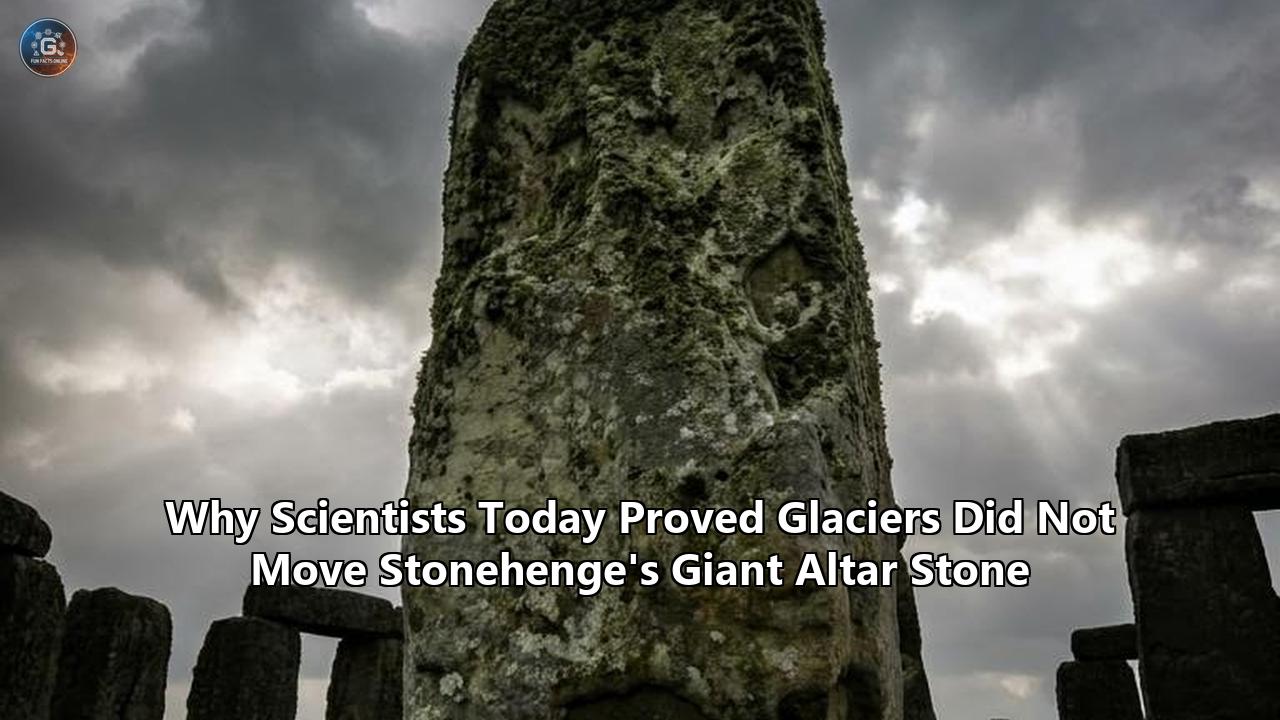
On June 4, 2026, a international research team published a study in the Journal of Quaternary Science that solved one of the most contentious debates in archaeological history. For over a century, scientists, geomorphologists, and historians have clashed over how the massive, six-tonne Altar Stone—the flat, green-gray sandstone block resting at the very heart of Stonehenge—traveled from its geological birthplace to the Salisbury Plain in Wiltshire.
The new study, titled From Highlands to Henge: Refining the Provenance and Transport Pathways of Stonehenge's Altar Stone, was led by Dr. Anthony Clarke of Curtin University and Dr. Remy Veness of Sheffield Hallam University. By pairing advanced mineral analysis with state-of-the-art computer simulations of Ice Age ice-sheet movements, the researchers proved that glaciers did not transport the Altar Stone directly from Scotland to southern England.
Instead, the team discovered a far more complex reality. While ancient glaciers did transport the six-tonne megalith part of the way during the last Ice Age, depositing it on what is now the submerged Dogger Bank in the North Sea, the ice sheets stopped hundreds of kilometers short of Salisbury Plain.
The implication is clear: the final, monumental leg of the journey was completed by Neolithic humans. Rather than a random act of glacial drift, the presence of the Altar Stone at Stonehenge was the result of a deliberate, highly coordinated multi-stage migration and salvage operation. This discovery fundamentally alters our understanding of prehistoric British society, revealing a level of long-distance communication, maritime skill, and cultural unity never previously documented in the Neolithic era.
Act I: The 1923 Welsh Hypothesis and the Century-Long Glacial Dispute
To appreciate why the June 2026 discovery is so significant, one must trace the history of Stonehenge geology back to the early 1920s. Stonehenge is composed of two primary stone types: the massive, outer sarsen stones, which are local silcretes sourced from the nearby Marlborough Downs, and the smaller, inner "bluestones".
In 1923, Herbert Henry Thomas, a geologist with the Geological Survey of Great Britain, published a landmark paper in The Antiquaries Journal. Thomas analyzed thin sections of the bluestones and concluded that they originated in the Preseli Hills of Pembrokeshire, West Wales, some 225 kilometers (140 miles) west of Stonehenge. Because the Altar Stone—a large, tabular block of micaceous sandstone—was found among these bluestones, Thomas grouped it with them, assuming it shared a Welsh origin. He proposed that the stone had been sourced from the Senni Beds or the Cosheston Group of the Old Red Sandstone in South Wales.
This Welsh attribution immediately ignited a fierce, hundred-year debate regarding the transport mechanism of the stones, dividing scientists into two primary camps: the "glacialists" and the "humanists".
- The Glacialist Camp: Led by geologists such as Professor J.D. Judd in 1902 and later championed by geomorphologist Dr. Brian John, this group argued that the transport of multi-tonne stones across hundreds of kilometers was far beyond the physical and technological capabilities of Neolithic communities. Instead, they proposed that during the Pleistocene epoch, the massive Irish Sea Ice Sheet swept southward, plucking up boulders from Wales and depositing them as "glacial erratics" on the Salisbury Plain. According to this theory, the builders of Stonehenge did not transport the stones from Wales; they simply collected them from the local landscape where the melting ice had left them.
- The Humanist Camp: This group, comprising most mainstream archaeologists and geologists, argued that there was no physical evidence of glacial drift on the Salisbury Plain. If a massive glacier had reached southern Wiltshire, it would have left behind a widespread layer of till, gravels, and smaller erratics of Welsh origin. Salisbury Plain, however, is entirely devoid of such deposits. Thomas himself argued that glacial transport was impossible because the southern margin of the Welsh ice sheets never reached far enough east or south to touch Wiltshire.
For nearly a century, this debate remained deadlocked. The humanist camp could not explain how prehistoric people possessed the engineering and logistical capability to transport these massive stones across land and water, while the glacialist camp could not explain the total absence of glacial deposits in southern England. The entire debate, however, was built on a flawed assumption: that the Altar Stone had come from Wales.
Act II: Geochemical Declassification and the Scotland Bombshell (2023–2024)
The first major crack in the Welsh consensus appeared in 2023. A team of geochemists, including Professor Richard Bevins of Aberystwyth University and Dr. Rob Ixer of University College London, began applying high-resolution chemical analysis to the Altar Stone. They analyzed the stone's mineralogy and compared it directly to the Old Red Sandstone formations of the Anglo-Welsh Basin.
The results were startling. The Altar Stone possessed an exceptionally high barium content—exceeding 1,025 parts per million (ppm)—which did not match any sandstone formations in Wales or southern England. In a 2023 paper, Bevins and his colleagues officially proposed that the Altar Stone should be "de-classified" as a bluestone, severing its assumed connection to the Welsh Preseli Hills. They suggested that scientists "broaden their horizons" and look north toward the Old Red Sandstone basins of northern Britain.
This set the stage for the August 2024 bombshell. Writing in the journal Nature, a team led by Anthony Clarke and Christopher Kirkland of Curtin University published a paper titled A Scottish provenance for the Altar Stone of Stonehenge.
+-----------------------------------------------------------------------------+
|                            The Mineral "Passport"                           |
|                                                                             |
|  [ Zircon Grains ]  -->  U-Pb Dating  -->  Ages: 1000 - 2000 Million Years   |
|                                            (Matches Laurentian Basement)    |
|                                                                             |
|  [ Apatite/Rutile ] -->  U-Pb Dating  -->  Ages: ~450 Million Years         |
|                                            (Matches Grampian Orogeny)       |
|                                                                             |
|  =========================================================================  |
|  Result: Perfect match to the Orcadian Basin, Northeast Scotland            |
+-----------------------------------------------------------------------------+
To find the Stonehenge Altar Stone origin, the collaborative research team used state-of-the-art mass spectrometry at Curtin's John de Laeter Centre to analyze microscopic mineral grains—specifically zircon, apatite, and rutile—extracted from fragments of the Altar Stone. These minerals act as a geological passport:
- Zircon Grains: Zircons are incredibly durable minerals that retain their chemical and isotopic signatures over billions of years. The U-Pb (uranium-lead) dating of the zircons in the Altar Stone yielded ages primarily between 1,000 and 2,000 million years old, indicating they were derived from an ancient Laurentian crystalline basement.
- Apatite and Rutile Grains: These minerals are more sensitive to thermal and tectonic events. The dating of these grains yielded a younger age peak of approximately 450 million years, reflecting the footprint of the Grampian Orogeny, a major mountain-building event in northern Britain.
By matching this highly specific dual-age signature to sedimentary basins across the British Isles, Clarke and his team discovered a perfect match: the Old Red Sandstone of the Orcadian Basin in northeastern Scotland, encompassing Caithness, the Orkney Islands, and the coastal fringes of the Moray Firth.
This revelation completely transformed the debate surrounding the Stonehenge Altar Stone origin, shifting the scientific gaze from the rugged hills of Wales to the windswept, ancient coastlines of northeast Scotland. The geographical gap between the stone's source and its final resting place had suddenly expanded from 225 kilometers to an astronomical 700 to 750 kilometers.
The discovery immediately reignited the glacial transport debate on a grand scale. How could a six-tonne sandstone block travel nearly the entire length of Great Britain? Could an ancient Ice Age glacier have carried the stone south from Scotland, or was this the work of Neolithic humans?
Act III: The River Mineral Fingerprint of January 2026
To resolve this monumental question, scientists needed to find physical evidence of ancient glacial pathways in southern England. If a glacier had indeed carried the Altar Stone (and potentially the Welsh bluestones) to Salisbury Plain, it would have left behind microscopic physical clues.
In January 2026, Anthony Clarke and Christopher Kirkland published a follow-up study in the journal Communications Earth & Environment titled Detrital zircon–apatite fingerprinting challenges glacial transport of Stonehenge's megaliths. This paper delivered the strongest scientific blow to the direct glacial transport theory yet seen.
Rather than analyzing the megaliths themselves, the research team turned their attention to the local landscape of Wiltshire. They collected samples of modern stream and river sediments from the catchments immediately surrounding Stonehenge on the Salisbury Plain.
                                  [ Glacial Hypothesis ]

         Northeast Scotland                              Salisbury Plain (Wiltshire)
        +------------------+     Glacial Transport      +---------------------------+
        |  Orcadian Basin  | =========================> | Expected: Scottish River  |
        |  Mineral Sign.   |                            | Sediment Fingerprints     |
        +------------------+                            +---------------------------+
                                                                      |
                                                                [ Reality ]
                                                                      |
                                                                      v
                                                        +---------------------------+
                                                        | Actual: Only Local Chalk  |
                                                        | & London Basin Minerals   |
                                                        +---------------------------+
The logic behind this methodology was elegant. If a massive, continental-scale glacier had traveled from northeastern Scotland (or even Wales) to southern England, it would have acted as a giant conveyor belt, dragging millions of tonnes of northern and western rocks, gravel, and sand along with it. When the glacier eventually melted, it would have deposited this foreign material across the Salisbury Plain as glacial drift. Over the subsequent thousands of years, rain and weathering would have washed these foreign minerals into local streams, where they would remain trapped in the river sands.
Using advanced mineral "fingerprinting" techniques, the team analyzed more than 700 individual grains of zircon and apatite from the Salisbury Plain river sediments.
- The Findings: The researchers found absolutely zero trace of Scottish or Welsh mineral signatures in the local stream sediments. The zircon ages in the Salisbury Plain river sands perfectly matched the local geology of southern England, reflecting sediments recycled from the local Cretaceous chalk and the nearby London Basin.
- The Verdict: The complete absence of northern mineral fingerprints proved mathematically that no Pleistocene glaciers from Scotland or Wales had ever extended as far south as Salisbury Plain. The ice sheets of the last Ice Age simply never reached southern Wiltshire.
This study effectively demolished the classic "direct glacial transport" theory. If glaciers never reached Salisbury Plain, they could not have deposited the Altar Stone at Stonehenge. However, one crucial puzzle piece remained. If the glaciers didn't bring the stone to Wiltshire, did they bring it part of the way?
Act IV: The June 2026 Climax—Confirming the Stonehenge Altar Stone Origin and the Glacial Ice Paths
This brings us to the breakthrough published on June 4, 2026. While the January 2026 study proved that glaciers did not reach Salisbury Plain, it did not model where the Scottish glaciers did go.
In their new paper in the Journal of Quaternary Science, Dr. Anthony Clarke, Dr. Remy Veness, and their colleagues sought to reconstruct the exact path of the British and Irish Ice Sheet (BIIS) during the Last Glacial Maximum (LGM), between 33,000 and 11,700 years ago, to see if ice could have assisted in moving the Altar Stone southward.
+-----------------------------------------------------------------------------------------+
|                        CHRONOLOGICAL TIMELINE OF SCIENTIFIC DISCOVERIES                 |
|                                                                                         |
|  1923: H.H. Thomas proposes Welsh origin for Altar Stone and bluestones.                |
|        Fierce debate begins between "glacialists" and "humanists".       |
|                                                                                         |
|  2023: Geochemists analyze barium levels; Altar Stone is officially                     |
|        "declassified" as a Welsh bluestone.                                     |
|                                                                                         |
|  Aug 2024: Bombshell Nature study uses mineral dating to trace the                      |
|            Stonehenge Altar Stone origin to the Orcadian Basin, Scotland.|
|                                                                                         |
|  Jan 2026: River sediment fingerprinting proves glaciers never reached                  |
|            Salisbury Plain, ruling out direct glacial delivery.          |
|                                                                                         |
|  Jun 2026: Ice-sheet modeling proves glaciers carried the stone to Dogger Bank,         |
|            but humans completed the remaining 400+ km transport.         |
+-----------------------------------------------------------------------------------------+
To map the Stonehenge Altar Stone origin and the potential transport pathways, the team combined geological provenance analysis with complex numerical modeling of Ice Age ice sheets. First, they narrowed down the potential geological source of the Altar Stone within the Orcadian Basin. By matching the specific zircon fingerprints of the Altar Stone with localized bedrock samples, they determined that the sandstone deposits in Caithness, on the northeastern tip of the Scottish mainland, produced the closest match.
Next, the team ran computer simulations to model the flow lines of the ancient glaciers that covered Caithness during the Last Glacial Maximum. They wanted to know: if a glacier plucked a six-tonne block of sandstone from Caithness, where would that ice stream carry it?
The simulations revealed two distinct glacial pathways:
- The Dominant Northeast Flow: The vast majority of the ice moving across Caithness flowed directly northeastward, out into the deep waters of the Atlantic Ocean. Any stones carried by this ice stream would have been dropped into the ocean and lost.
- The Southeast Deflection: A narrower, powerful ice stream was deflected southeastward by the massive Scandinavian Ice Sheet. This glacial conveyor belt carried land-derived rocks from northeastern Scotland across the dry basin of what is now the North Sea, depositing them at Dogger Bank—a elevated landmass that formed the heart of Doggerland.
Dogger Bank, which is now submerged beneath the North Sea, was a dry, fertile landmass that connected Great Britain to continental Europe during and immediately after the last Ice Age. Because Dogger Bank consists entirely of soft sedimentary soils, it contains absolutely no natural rock outcroppings. Therefore, any large stones or boulders found on Dogger Bank during the early Holocene must have been carried there as glacial erratics.
The computer models confirmed that while glaciers could have transported the Altar Stone from Scotland to Dogger Bank, they did not flow any further south. There were no viable glacial pathways connecting either Caithness or Dogger Bank to southern England.
"Our modeling shows glaciers may have transported rocks part of the way during the last Ice Age — potentially as far as Dogger Bank in the North Sea — but not into southern England," explained Dr. Anthony Clarke. "This means the stone would still have needed to be moved hundreds of kilometers by people."
The Doggerland Rescue: Climate-Induced Migration and Ancient Engineering
The discovery that the Altar Stone was deposited on Dogger Bank by glaciers, only to be moved hundreds of kilometers south by Neolithic humans, introduces a breathtaking new narrative. It bridges the gap between the glacialist and humanist theories, revealing that both ice and human hands played a role in the monument's creation.
More importantly, it provides a compelling explanation for why prehistoric people would attempt the seemingly impossible task of moving a six-tonne stone across hundreds of kilometers of rugged terrain.
                     THE RECONSTRUCTED MULTI-STAGE JOURNEY

Stage 1: Glacial Transport (~22,000 Years Ago)
         Northeast Scotland (Caithness)  --->  Dogger Bank (Doggerland)
         [ Glaciers carry the 6-tonne block to a stone-free plain ]

Stage 2: Cultural Adoption (Early Holocene)
         The prehistoric inhabitants of Doggerland discover the exotic stone,
         attaching deep spiritual and symbolic value to it.

Stage 3: The Climate Salvage (End of Last Ice Age)
         Rising sea levels begin to submerge Doggerland.
         People migrate to mainland Britain, dragging the Altar Stone with them.

Stage 4: The Final Henge (Neolithic Era)
         The Altar Stone is transported across southern England,
         incorporating it into the center of Stonehenge.
During the early Holocene, Doggerland was a highly fertile, resource-rich plain inhabited by thriving Mesolithic and early Neolithic communities. Because Doggerland was completely devoid of natural stone outcroppings, a massive, six-tonne block of glistening, green-gray micaceous sandstone sitting on Dogger Bank would have been an extraordinary landmark.
"What is exciting about these findings is that they could imply that the people of Doggerland attached cultural significance to the Altar Stone long before it was incorporated into Stonehenge," said Dr. Remy Veness.
As the global climate warmed at the end of the last Ice Age, the massive ice sheets melted, and global sea levels began to rise rapidly. Over generations, the low-lying plains of Doggerland were slowly devoured by the North Sea. This ecological crisis forced the inhabitants of Doggerland into a prolonged, climate-induced migration, forcing them to abandon their ancestral hunting grounds and move westward onto the higher ground of mainland Britain.
Rather than abandon their sacred, symbolic monolith to the rising tide, these ancient communities launched an audacious salvage mission.
"The Altar Stone must have been significant enough [for people] to be willing to move the stone at least twice; first to save it from being submerged by rising sea levels at the end of the last ice age, and then again to its final resting place on Salisbury Plains," Dr. Veness noted. "Moving the stone in response to rising sea levels as the world's ice sheets melted at the end of the last ice age goes some way to explaining why such an audacious move might have been attempted."
Moving a six-tonne stone from the threatened lands of Doggerland to southern England was an engineering feat that required incredible organization. The researchers propose that the journey was completed in stages, utilizing a combination of water and land routes:
- Maritime and Riverine Transport: Prehistoric Britons likely floated the massive stone along the coast and up major river estuaries. Using large, lashed dugout canoes or specialized rafts, they could have navigated the coastal waters of eastern England, significantly reducing the friction of overland transport.
- Overland Hauling: Where water transport was impossible, the stone would have been dragged overland using wooden sledges and rollers.
- The Berkshire Ridgeway: The study suggests that once the stone reached the mainland, it may have been transported close to the Berkshire Ridgeway. As the oldest continuous road in Europe, this ancient trackway was actively used during the Neolithic period and would have provided a relatively stable, high-road route directly to the Salisbury Plain.
This epic journey demonstrates a level of social cohesion and cooperation among Neolithic communities that has never been fully appreciated. It proves that prehistoric Britain was not a collection of isolated, primitive tribes, but rather a highly connected, sophisticated society capable of planning, executing, and sustaining complex logistical operations over generations.
The Future of Stonehenge Archaeology
The June 2026 study has resolved one of archaeology's longest-standing puzzles, but it has simultaneously opened up a wealth of new scientific inquiries.
The immediate next step for the research team is to pinpoint the exact, square-meter outcrop in Caithness, northeastern Scotland, where the Altar Stone was originally quarried by the glacier. By taking highly localized bedrock samples across the Orcadian Basin and comparing their microscopic zircon, apatite, and rutile signatures, geochemists hope to identify the precise physical origin of the stone.
Additionally, marine archaeologists are turning their attention to the submerged landscapes of the North Sea. Using advanced sonar and sub-bottom profiling, researchers hope to locate ancient, drowned Neolithic settlements on Dogger Bank. Finding physical evidence of human habitation, or potentially even the temporary resting sites of the Altar Stone on its journey, would provide physical validation of the Doggerland migration theory.
Ultimately, the revelation that glaciers did not move the Altar Stone directly to Stonehenge reframes the entire monument. It is no longer seen as a local Wiltshire temple, but rather as an island-spanning monument of collective resilience—a physical anchor point built to unite communities displaced by a changing climate. The Altar Stone stands as a testament to prehistoric human ingenuity, cooperation, and determination in the face of rising seas.
Reference:
- https://www.belfasttelegraph.co.uk/news/uk/stonehenge-altar-stone-may-have-travelled-from-scotland-via-glacier-study/a/155201323.html
- https://www.sciencefocus.com/news/we-may-have-just-cracked-one-of-stonehenges-greatest-mysteries
- https://www.hellorayo.co.uk/greatest-hits/salisbury/news/stonehenge-altar-stone-scotland-glacier-study
- https://www.salisburyjournal.co.uk/news/26164954.part-stonehenge-may-glacier-travelled-scottish-rock/
- https://www.sci.news/archaeology/stonehenges-giant-altar-stone-14818.html
- https://archaeologymag.com/2026/06/study-reveals-how-stonehenges-altar-stone-crossed-britain/
- https://www.heritagedaily.com/2024/06/new-study-upends-prevailing-theory-on-transportation-of-stonehenge-bluestones/152473
- https://www.researchgate.net/publication/394479847_The_Stonehenge_Glacial_Transport_Theory
- http://www.stonehengemonument.co.uk/2024/08/the-scottish-stone.html
- https://www.thebritishacademy.ac.uk/documents/3923/92p271.pdf
- https://egqsj.copernicus.org/articles/73/117/2024/
- https://brian-mountainman.blogspot.com/2024/04/hh-thomas-knowingly-misrepresented.html
- https://pubmed.ncbi.nlm.nih.gov/39143341/
- https://www.nessofbrodgar.co.uk/altar-stone-2024/
- https://www.discovermagazine.com/neolithic-humans-not-glaciers-likely-transported-stonehenge-s-altar-stone-over-400-miles-49206
- https://www.eurekalert.org/news-releases/1053983
- https://www.curtin.edu.au/research/news/curtin-scientists-freeze-out-ice-age-delivery-theory-for-stonehenge-stones?type=media
- https://brian-mountainman.blogspot.com/2026/03/probable-bias-in-zircon-apatite.html
- https://www.researchgate.net/publication/399952024_Detrital_zircon-apatite_fingerprinting_challenges_glacial_transport_of_Stonehenge's_megaliths
- https://en.socportal.info/en/news/how-a-six-tonne-stone-from-scotland-ended-up-at-the-centre-of-stonehenge/
- https://www.jpost.com/archaeology/archaeology-around-the-world/article-885395
- https://www.sheffieldforum.co.uk/topic/501705-sheffield-hallam-research-rewrites-the-story-of-how-stonehenges-altar-stone-got-there/
- https://www.radionewshub.com/articles/news-updates/Stonehenge-altar-stone-may-have-travelled-from-Scotland