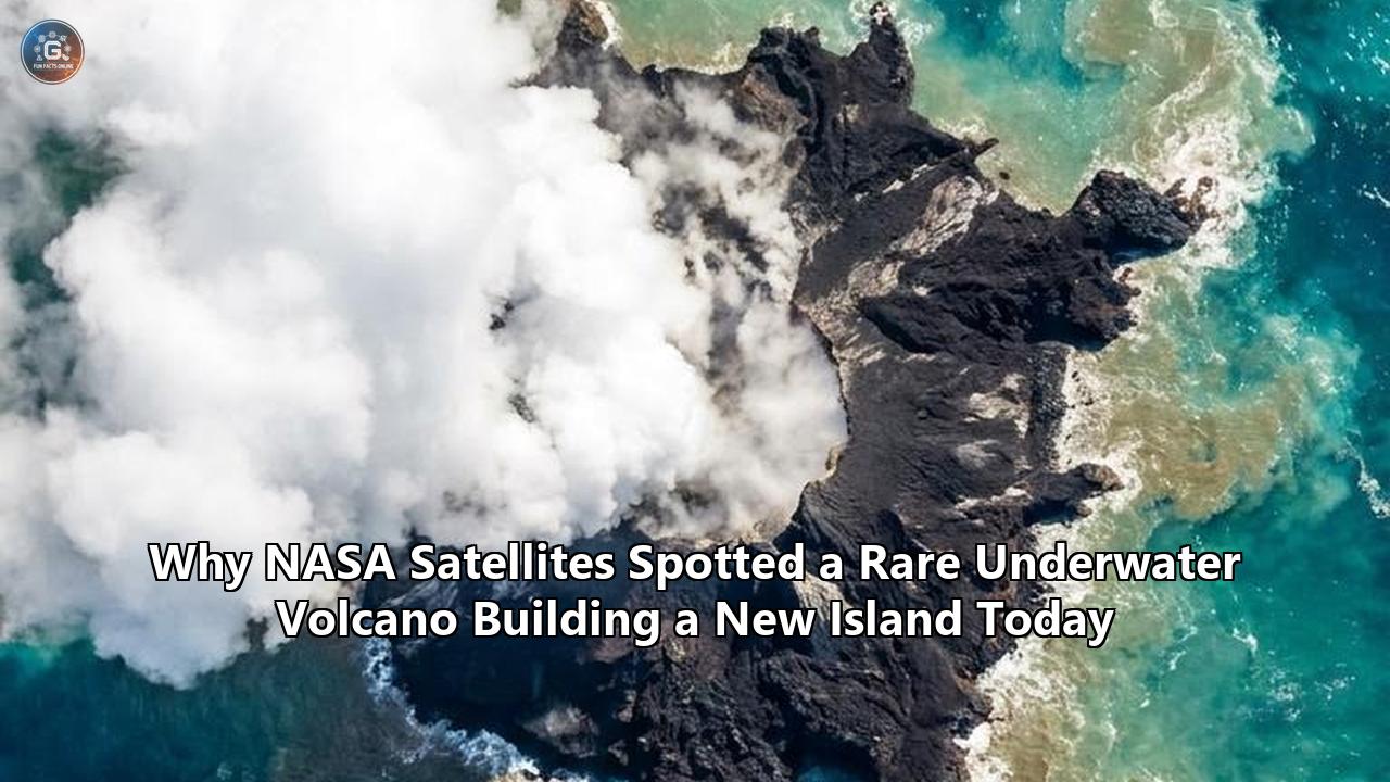
Today, in the remote reaches of the Central Bismarck Sea, NASA satellites are capturing the spectacular birth of what could soon become Earth’s newest piece of land. A massive, unexpected submarine eruption along a geological feature known as the Titan Ridge—located approximately 125 kilometers (78 miles) southeast of Manus Island, Papua New Guinea—has built a towering volcanic platform from a vent that once sat 1,300 meters (4,265 feet) below the ocean surface.
The eruption, which began on May 8, 2026, has escalated over the past several weeks, steadily pushing an underwater mountain toward the surface. It is venting towering columns of steam and volcanic ash up to 13,000 feet (4,000 meters) into the atmosphere. Below, it is disgorging millions of tons of frothy, gas-filled lava that cools rapidly upon contact with the frigid sea, creating vast sheets of floating pumice. These rafts of volcanic rock have drifted across Manus Province, choking pristine bays, trapping coastal fishing communities in "deserts of stone," and threatening local coral reefs.
For scientists, this dramatic event is much more than a localized hazard. It represents a rare, highly visible example of underwater volcano island formation captured in real-time by a new generation of Earth-observing satellites. By monitoring the Titan Ridge Volcano, researchers are gaining invaluable insights into the thermodynamic forces that shape our planet's crust, the ecological recovery of sterile volcanic environments, and the geological history of other planetary bodies like Mars and Venus.
The Titan Ridge Awakening: What Is Happening Today
The first signs of this geological event emerged on May 8, 2026, when local seismometers in Papua New Guinea detected a brief, energetic swarm of shallow earthquakes beneath the central basin of the Bismarck Sea. Within 24 hours, the sea itself began to vent the eruption's signatures to the atmosphere. NASA’s polar-orbiting Aqua and Terra satellites, equipped with the Moderate Resolution Imaging Spectroradiometer (MODIS), captured bright, white, steam-rich plumes rising from a stretch of open ocean that had previously been dark, quiet, and seemingly empty.
               PHREATOMAGMATIC ERUPTION MECHANISM

                      [ 13,000 ft Ash Plume ]
                                ^
                                |
                         ~~~~~~~~~~~~~  <-- Ocean Surface
                        /             \
                       /  Steam & Ash  \
                      /   Explosions    \
                     |~~~~~~~~~~~~~~~~~~~|
                     |                   |
                     |  Hydrostatic      |  <-- High pressure limits
                     |  Pressure         |      explosive force
                     |                   |
                     |     /=======\     |
                     |    /  Titan  \    |  <-- Rapid accumulation
                     |   /   Ridge   \   |      of pillow basalt
                     |  /   Platform  \  |      & volcanic debris
                     |===================|
                     |                   |
                     |   Active Vent     |  <-- Magma at 1,100°C
                     |  (-1,300 meters)  |      meets cold seawater
                     +-------------------+
By mid-May, the Darwin Volcanic Ash Advisory Centre issued warnings to commercial aviation as the volcanic column breached 9,000 feet, eventually climbing to 13,000 feet as the eruption intensity expanded. The physical mechanism behind this dramatic atmospheric breakthrough is a phreatomagmatic eruption. When molten basaltic magma at temperatures exceeding 1,100°C (2,012°F) meets seawater under high pressure, the water flash-boils into steam, expanding its volume by an estimated 1,700 times almost instantaneously. This explosive thermal expansion shatters the rising magma into fine ash, driving a powerful, buoyant jet of superheated steam, gas, and particulate matter up through more than a kilometer of ocean water.
Today, the eruption has established a dual-vent structure spaced roughly 2.5 kilometers apart along the Titan Ridge. Hydroacoustic signals recorded by stations on Manus Island, as well as remote arrays as far away as Wake Island and Midway Island in the central Pacific, indicate that the magma ascent is continuous and stable. The volcano is rapidly accumulating material, constructing a broad underwater platform of pillow lavas, hyaloclastites, and volcanic breccia.
As the summit of this underwater mountain nears the sea surface, the hydrostatic pressure holding back the gas bubbles in the lava is dropping. The result is a dramatic increase in the production of pumice—a glass-like, highly vesicular rock so filled with trapped gas cavities that its bulk density is lower than that of water, allowing it to float. These floating rocky carpets now cover hundreds of square kilometers of the Bismarck Sea, serving as a stark reminder of the immense volume of material being relocated from the Earth's mantle to its surface.
The Physics of Phreatomagmatic Eruptions: Fire Meets Water
To understand why the Titan Ridge eruption is successfully building an island while thousands of other submarine volcanoes erupt unnoticed, we must examine the delicate physics governing magma-water interactions.
Roughly 75% of Earth's volcanic output occurs underwater, primarily along mid-ocean ridges and back-arc spreading centers. Yet, the vast majority of these events never make an impact at the surface. They are kept in check by the crushing weight of the deep ocean.
Hydrostatic Pressure and the Critical Depth
At a depth of 1,300 meters—the initial level of the active vent on Titan Ridge—the hydrostatic pressure is approximately 130 times atmospheric pressure (about 13 megapascals). Under this tremendous pressure:
- Gases dissolved in the magma (such as water vapor, carbon dioxide, and sulfur dioxide) are kept in solution, preventing the explosive decompression that characterizes land-based eruptions.
- Seawater is kept at a density and pressure that highly dampens thermal explosions.
- The magma extruded at these depths typically oozes out quietly, cooling into rounded, tube-like formations called pillow basalts.
For a volcanic column to pierce the ocean surface and begin underwater volcano island formation, the eruptive rate must be high enough to overcome this hydrostatic damping, or the vent must already be in relatively shallow water. Titan Ridge has achieved the former. The sheer volume of magma moving through the volcanic conduit has created a localized, superheated steam corridor. By heating the surrounding water column to its boiling point, the volcano has effectively insulated its primary conduit, allowing subsequent pulses of magma to travel upward without being instantly quenched by cold seawater.
| Geological Stage | Depth Range (m) | Dominant Volcanic Products | Physical Process |
|---|---|---|---|
| Deep Submarine Phase | $>1,000$ | Pillow basalts, sheet flows, hydrothermal deposits | Effusive extrusion; high hydrostatic pressure suppresses degassing and fragmentation. |
| Shallow Submarine Phase | $100 - 1,000$ | Hyaloclastites, vesicular basalt, volcanic breccia | Intermittent fragmentation; lowering hydrostatic pressure allows magmatic volatile expansion. |
| Surtseyan / Phreatomagmatic Phase | $0 - 100$ | Fine ash, lapilli, pumice, steam-rich columns | Violent explosive interaction; rapid conversion of water to steam; severe fragmentation of lava. |
| Subaerial Stabilization | $>0$ (Above sea level) | Aa and pahoehoe lava flows, cinder cones, epiclastic deposits | Transition to dry subaerial volcanism; wind and wave erosion battle against active lava supply. |
The transition from the deep submarine phase to the shallow phreatomagmatic phase is marked by a feedback loop. As the volcanic pile grows taller, the hydrostatic pressure at its summit decreases. This reduction in pressure allows dissolved gases within the magma to rapidly expand and nucleate into bubbles (vesicles).
When the gas-rich lava is erupted into shallow, low-pressure waters, these bubbles expand so rapidly that they shatter the cooling lava into a froth of glass and ash. The resulting explosive interaction, known as a Surtseyan eruption (named after the formation of Surtsey island in Iceland in 1963), produces the spectacular, dark, ash-laden fingers of debris and white steam plumes currently being tracked by NASA's satellites.
The Remote Sensing Revolution: How NASA’s Fleet Tracks the Unseen
Historically, submarine eruptions were discovered only when ships happened to sail through pumice rafts, or when coastal communities felt earthquakes and saw distant steam plumes on the horizon. Today, NASA’s orbital fleet has transformed how we study these events, allowing scientists to monitor the entire lifecycle of an emerging island from space.
Landsat-9: High-Resolution Structural and Thermal Mapping
NASA and the U.S. Geological Survey’s Landsat-9 satellite, orbiting at an altitude of 705 kilometers, provides critical high-resolution structural and thermal data through its Operational Land Imager (OLI) and Thermal Infrared Sensor (TIRS).
On May 11, 2026, just three days after the Titan Ridge eruption began, Landsat-9 captured detailed, natural-color images of the Bismarck Sea. These images showed a series of tightly spaced volcanic plumes rising from a core of highly disturbed water, surrounded by massive, tan-colored bands of floating pumice.
       LANDSAT-9 MULTISPECTRAL DETECTOR BANDS (OLI-2 / TIRS-2)

  [Band 2 - Blue] -------> Captures water clarity & sediment dispersion
  [Band 3 - Green] ------> Maps acidic hydrothermal plumes (dissolved sulfur)
  [Band 5 - Near-IR] ----> Tracks vegetative boundaries & coastal shorelines
  [Band 6 - SWIR-1] -----> Resolves shortwave infrared (high-temperature anomalies)
  [Band 10 - Thermal] ---> Measures surface temperatures & thermal ocean plumes
By switching to false-color composites that integrate shortwave infrared (SWIR) wavelengths, scientists were able to look through the steam and clouds to isolate the thermal signature of the underwater vents. The SWIR sensors detected intense localized heat anomalies directly over the vents, confirming that active, molten lava was being extruded at or very near the ocean surface.
The PACE Satellite: Hyperspectral Ocean Color Dynamics
While Landsat-9 provides high-resolution spatial snapshots, NASA’s recently launched PACE (Plankton, Aerosol, Cloud, ocean Ecosystem) satellite is providing a revolutionary look at the biogeochemical changes taking place in the waters surrounding the eruption.
PACE's primary instrument, the Ocean Color Instrument (OCI), is a hyperspectral sensor that observes the Earth across several hundred different wavelengths of light, spanning the ultraviolet, visible, and near-infrared spectrums.
Rather than just seeing "discolored water," PACE’s hyperspectral data allows oceanographers to fingerprint the exact chemical constituents of the volcanic plume. The superheated seawater venting from Titan Ridge is highly acidic and enriched with:
- Dissolved sulfur compounds (which dye the water a brilliant, milky turquoise-green).
- Heavy metals and silica-rich volcanic ash particulates.
- Hydrothermal iron, which acts as a powerful fertilizer for microscopic marine algae.
                   PACE HYPERSPECTRAL SIGNAL SPECIFICATION

  UV Wavelengths (350-400 nm) ------> Measures volcanic SO2 aerosols in air
  Visible Blue-Green (400-550 nm) --> Identifies chemical compounds (Fe, S) in water
  Near-Infrared (700-900 nm) -------> Resolves density of floating pumice rafts
By analyzing the specific light-scattering properties of the water, PACE can map the concentration and movement of these toxic, superheated plumes as they drift with ocean currents. This capability is vital for assessing the immediate ecological impact of the eruption on surrounding fisheries and marine reserves.
MODIS and Himawari-9: Continuous Atmospheric Monitoring
To track the rapid, hour-by-hour dynamics of the eruption column, scientists rely on the Moderate Resolution Imaging Spectroradiometer (MODIS) aboard NASA's Terra and Aqua satellites, alongside the Japan Meteorological Agency's Himawari-9 geostationary satellite.
Because Himawari-9 remains fixed over the Asia-Pacific region, it provides near-continuous imagery of the volcanic plume's height, drift velocity, and ash composition. This multi-tiered satellite network ensures that even when regional weather clouds obscure the sea surface, a combination of radar, thermal, and geostationary observations can keep scientists continuously updated on the volcano’s progress.
Case Study: The Mechanics of Underwater Volcano Island Formation
The birth of a volcanic island is a complex, multi-stage geological process. By analyzing the Titan Ridge event as a primary case study, and comparing it to historical occurrences, we can extract the fundamental stages of underwater volcano island formation.
                STAGES OF UNDERWATER VOLCANO ISLAND FORMATION

   Stage 1: Deep Submarine        Stage 2: Shallow Submarine (Tuff Pile)
        Ocean Surface                  Ocean Surface
     ~~~~~~~~~~~~~~~~~~             ~~~~~~~~~~~~~~~~~~
                                          /\   (Venting steam)
                                         /  \
            _/\_                        /    \   <- Accumulating
           /    \  <- Basalt           /      \     fragmented debris
          /      \    Pillows         /  Vent  \
     ----+--------+----          ----+----+----+----

   Stage 3: Surtseyan (Phreatic)  Stage 4: Subaerial (Shield/Cone)
        Ocean Surface                  Ocean Surface
        ~~~/ \~~~                      ~~~|   |~~~  <- Wave erosion
          /   \  <- Violent              /     \       battles lava
         /  V  \    explosions          /   V   \      stabilization
        /       \                      /         \
     --+---------+--                --+-----------+--
Stage 1: The Seafloor Accumulation Phase
All volcanic islands begin as deep submarine seamounts. In this initial stage, which can last for tens of thousands of years, the volcano builds a broad, shield-like base on the ocean floor. The primary structural material is pillow basalt—spherical, glassy-skinned lava lobes that form when molten rock is extruded into cold water and instantly crusts over, only for the pressurized lava inside to break through and form a new lobe.
At Titan Ridge, this phase took place silently over decades, building upon a complex tectonic junction where the northern edge of the South Bismarck plate meets a transform fault and a back-arc spreading center. This unique tectonic setting provides a continuous pathway for basaltic magma to ascend from the mantle, fueling the rapid growth of the volcanic edifice.
Stage 2: The Shallow-Water Fragmented Phase
As the summit of the seamount breaches depths of less than 200 meters, the geological style of the eruption changes dramatically. The crushing hydrostatic pressure of the deep ocean is no longer strong enough to suppress the expansion of magmatic gases.
The lava begins to fragment violently upon extrusion, creating massive deposits of hyaloclastite (glassy, fragmented debris) and volcanic ash. This material does not form the solid, durable structures of pillow basalts; instead, it piles up as a loose, steep-sided cone of rubble. This is the stage Titan Ridge transitioned through in early May 2026, as evidenced by the sudden appearance of surface plumes and seismic swarms.
Stage 3: The Surtseyan (Phreatomagmatic) Island-Building Phase
This is the critical transition where the volcanic structure actually breaches the sea surface, creating a transient island. When the vent is shallow enough to allow seawater to continuously pour in but deep enough that the water cannot easily drain away, explosive steam-driven eruptions occur.
                               THE SURTSEYAN CYCLE

   +------------------+     +-------------------+     +------------------+
   |  Seawater Enters | --> | Instantaneous     | --> | Violent Steam    |
   |  Shallow Vent    |     | Thermal Expansion |     | Explosion        |
   +------------------+     +-------------------+     +------------------+
            ^                                                   |
            |                                                   v
   +------------------+                               +------------------+
   | Loose Tuff Cone  | <---------------------------- | Magma Shattered  |
   | Wall Collapses   |                               | Into Fine Ash    |
   +------------------+                               +------------------+
This cycle produces a distinctive circular or crescent-shaped landmass known as a tuff cone, made up of layers of ash, lapilli, and pumice.
A primary historical example of this is the 1963 eruption of Surtsey off the southern coast of Iceland. Over several years, Surtsey successfully built a durable subaerial island by transitioning from explosive phreatic activity to effusive basaltic lava flows that capped and protected the easily erodible ash deposits.
More recently, the eruption of Home Reef in Tonga (2022) and an unnamed eruption off the coast of Iwo Jima, Japan (2023) demonstrated how rapidly these islands can emerge—often rising above the waves within 11 to 24 hours of starting.
Stage 4: The Subaerial Stabilization Phase
Once a volcanic island rises above sea level, it enters a high-stakes geological race against the ocean. Ocean waves, tides, and storms immediately begin to erode the loose ash and pumice of the newly formed landmass.
If the volcanic activity ceases shortly after the island's birth, marine erosion will quickly wash the loose rubble back into the sea, reducing the island to a submerged shoal or reef. This was the fate of the ephemeral islands produced by Tonga's Home Reef in 1852, 1857, 1984, and 2006.
                     ISLAND SURVIVAL DETERMINANTS

  EPHEMERAL ISLAND (Home Reef style)     PERMANENT ISLAND (Surtsey/Nishinoshima style)

      Loose Ash / Pumice                     Solid Basaltic Cap
         ~~~~~~~~~~~~~                          ~~~~~~~~~~~~~
           /       \                              /=======\
          /  Loose  \                            /  Solid  \
         /   Tuff    \                          /   Lava    \
        /             \                        /   Shield    \
       -----------------                      -----------------
  Erosion washes it away within          Lava flows armor the island;
  weeks or months.              hydrothermal processes bake ash
                                         into hard rock (palagonite).
To survive, the island must achieve two milestones:
- Effusive Transition: The eruption must shift from explosive, water-rich phreatic activity to dry, effusive volcanism. This occurs when the growing tuff cone successfully seals off the vent from the surrounding sea, allowing pure lava to flow out over the land. These subaerial lava flows (either blocky aa or smooth pahoehoe) act as a protective suit of armor, capping the easily erodible ash layers with durable, solid basalt.
- Palagonitization: The heat from the volcanic system must interact with seawater trapped within the ash cone, driving hydrothermal reactions that alter the soft, glassy volcanic ash into a tough, clay-rich rock called palagonite. This process essentially "bakes" the loose ash pile into solid concrete, dramatically increasing its resistance to wave action.
The Titan Ridge Volcano is currently in the critical transition between Stage 2 and Stage 3. It is rapidly accumulating the fragmented rubble necessary to build a stable subaerial platform, while its dual vents continue to pour massive amounts of material into the shallow water column.
The Ecological Shockwave: Pumice Rafts and the Human Toll
While the scientific community views the Titan Ridge eruption with excitement, for the coastal populations of Papua New Guinea's Manus Province, the birth of this new island has triggered a localized humanitarian and ecological crisis.
The Physics and Genesis of Pumice Rafts
As the superheated, gas-rich basaltic magma from Titan Ridge ascends into shallow water, the dramatic drop in hydrostatic pressure causes dissolved gases to expand violently. This process, known as magmatic vesicularion, transforms the liquid rock into a hot, mineral-rich foam.
When this foam is quenched by the cold seawater, it solidifies into pumice—a highly porous volcanic glass filled with millions of microscopic, sealed gas pockets.
Because these gas pockets are isolated from one another, water cannot easily penetrate the interior of the rock. The bulk density of the pumice remains significantly lower than that of seawater, causing it to rise to the surface and float.
As the Titan Ridge eruption has continued, it has generated an immense volume of this floating material, which wind, waves, and ocean currents have swept together into massive, semi-solid rafts stretching across the Bismarck Sea.
                        ANATOMY OF A PUMICE RAFT

             Wind & Current Direction --->
   ~~~~~~~~~~~~~~~~~~~~~~~~~~~~~~~~~~~~~~~~~~~~~~~~~~~~~~~~~~~~~~~  <-- Sea Level
     [Pumice Block]  [Pumice Block]  [Pumice Block]  [Pumice Block]
     - Porous glass  - Blocks light  - Traps heat    - Suffocates
     - Gas-filled    - Traps boats   - Grinds hulls    coral below
   ~~~~~~~~~~~~~~~~~~~~~~~~~~~~~~~~~~~~~~~~~~~~~~~~~~~~~~~~~~~~~~~
The Manus Province Crisis: Trapped Communities
In late May and early June 2026, changing winds and tidal currents pushed these sprawling pumice rafts directly into the coastal waters of Manus Province. For communities like Bound Village on Low Island, the impact was immediate and severe.
The floating volcanic stones accumulated in coastal lagoons and narrow channels, packing together so densely that they formed solid, stone blankets up to several feet thick across the water's surface.
                                MANUS PROVINCE
                         PUMICE IMPACT ASSESSMENT

  +--------------------------+------------------------------------------------+
  | Impact Sector            | Primary Consequences                           |
  +--------------------------+------------------------------------------------+
  | Maritime Transportation  | Outboard motors destroyed by abrasive dust;     |
  |                          | hulls grounded; complete loss of mobility.|
  +--------------------------+------------------------------------------------+
  | Food Security & Economy  | Artisanal fishing halted; communities unable to |
  |                          | reach local mainland markets.           |
  +--------------------------+------------------------------------------------+
  | Public Health            | Waterways blocked, preventing access to         |
  |                          | medical clinics and emergency aid.      |
  +--------------------------+------------------------------------------------+
  | Marine Ecology           | Sunlight blocked; photosynthesis halted; coral  |
  |                          | reefs smothered by settling abrasive dust.|
  +--------------------------+------------------------------------------------+
Local residents described the ocean as looking like "a desert of rock". Because these communities rely entirely on small, outboard-powered fiberglass boats for transportation, the dense pumice rafts have effectively marooned them.
Attempting to navigate through the pumice is impossible; the abrasive volcanic glass quickly destroys the cooling water pumps of outboard engines, scores propeller blades, and can easily grind through thin boat hulls. As a result, seafaring villagers have been cut off from access to mainland food markets, fresh water supplies, and medical centers.
"We are stuck in the village, unable to travel out to market or go out to fish," reported one local resident from Low Island. The Papua New Guinea government, in coordination with regional disaster management teams, has launched urgent assessments to deliver emergency food, fresh water, and fuel to the isolated islands.
Ecological Devastation of Marine Ecosystems
Beyond the human impact, the massive sheets of floating pumice are causing severe ecological damage to the highly biodiverse marine habitats of the Bismarck Sea Volcanic Province.
The primary ecological threats include:
- Light Starvation: The solid, opaque sheets of floating pumice block sunlight from penetrating the water column. This halts photosynthesis in zooxanthellae—the symbiotic algae living inside coral tissues—as well as phytoplankton, the foundation of the marine food web. If the cover persists for more than a few weeks, widespread coral bleaching and die-offs will occur.
- Abrasive Smothering: As wave action grinds the floating pumice blocks together, they disintegrate into a fine, highly abrasive volcanic dust. This heavy particulate matter slowly settles to the seafloor, coating coral reefs in a thick layer of silty glass that smothers the living coral polyps and clogs the delicate filtering mechanisms of sponges, clams, and other benthic organisms.
- Physical Suffocation: Fish and other marine life are highly vulnerable to the suspended volcanic ash. The sharp, jagged silica particles damage delicate gill membranes, leading to respiratory failure and mass mortality events in local fish populations.
Earth as a Cosmic Laboratory: The "Island-Naut" Perspective
While the immediate geological and human dramas unfold in the Bismarck Sea, planetary scientists are looking at the Titan Ridge eruption through an entirely different lens: as a window into the ancient history of other worlds.
Jim Garvin and the "Island-Naut" Paradigm
Jim Garvin, the Chief Scientist at NASA's Goddard Space Flight Center, has been a leading proponent of using newly formed volcanic islands as analog environments for space exploration. Garvin and his team coined the term "island-nauts" to describe researchers who study how these sterile, newly emerged landmasses are altered by erosion, colonized by pioneering biology, and chemically weathered by wind and water.
                     THE "ISLAND-NAUT" FRAMEWORK

  Volcanic Birth --> Rapid Sterile Crust --> Mechanical Erosion --> Biological Invasion
        ^                                                                  |
        |__________________________________________________________________|
                  Underpins Martian Astrobiology & Artemis IV Training
"This new eruption could present an even better opportunity for 'island-naut' exploration as we prepare to return to the moon with women and men via Artemis IV," Garvin stated, highlighting the direct connection between deep-sea volcanism and planetary exploration.
Volcanic Islands as Mars and Venus Analogs
On Mars, massive volcanic features such as Olympus Mons, Arsia Mons, and Elysium Mons dominate the landscape. Millions of years ago, Mars was a geologically active world with vast shallow oceans and lakes. Many of the volcanic structures observed on Mars' surface today bear a striking resemblance to Earth's submarine and subaerial volcanic landmasses.
       PLANETARY ANALOG CORRELATIONS (EARTH vs. MARS/VENUS)

  Earth Feature (Titan Ridge)          Martian / Venusian Analog
  ---------------------------          -------------------------
  Pillow Basalts (Deep Vent) --------> Ancient ocean basins (Eridania Lake, Mars)
  Surtseyan Tuff Cones --------------> Hydrovolcanic cones (Athabasca Valles, Mars)
  Palagonitized Ash (Baked Rock) ----> Highly weathered, clay-rich Martian soil
  Hydrothermal Venting --------------> Promising targets for ancient life searches
By studying how the Titan Ridge Volcano builds new land, scientists can refine their models of:
- Hydrovolcanism on Mars: Understanding how basaltic magma interacted with ancient Martian surface water or sub-surface ice sheets. This is crucial for interpreting the geologic layers observed by Mars rovers like Perseverance and Curiosity.
- Astrobiological Niches: Newly formed volcanic islands are highly sterile environments, yet they are immediately populated by microbial communities that thrive on the chemical energy of hydrothermal venting. By studying how microbes colonize the fresh basaltic glass of Titan Ridge, astrobiologists can identify the biosignatures most likely to preserve evidence of ancient life on Mars or Venus.
- Venusian Tectonic Analogs: Venus is covered in thousands of volcanic features, many of which are believed to be currently active. Because Venus lacks a global plate tectonic system like Earth, its volcanic activity is dominated by mantle plumes and localized rifting—geological mechanisms highly analogous to the back-arc spreading center currently fueling the Titan Ridge eruption in the Bismarck Sea.
The Transient Nature of Volcanic Islands: Lessons from the Past
The fundamental lesson of marine geology is that volcanic islands are, by their very nature, temporary features of the Earth’s surface. The vast majority of islands built by underwater volcanoes do not survive their infancy.
To put the Titan Ridge eruption into perspective, we must examine historical case studies that highlight the varied pathways of underwater volcano island formation.
                         VOLCANIC ISLAND LIFECYCLE PATHS

                      [ Active Submarine Eruption ]
                                    |
                                    v
                        [ Breaches Sea Surface ]
                                    |
            +-----------------------+-----------------------+
            |                                               |
            v                                               v
  [ Inactive Eruptive Phase ]                    [ Continuous Lava Flow ]
            |                                               |
            v                                               v
    [ Rapid Wave Erosion ]                       [ Shield Stabilization ]
            |                                               |
            v                                               v
    [ Submerged Shoal ]                         [ Long-Term Island Colonization ]
   (Home Reef / Metis Shoal)                       (Surtsey / Nishinoshima)
The Surtsey Miracle (1963–1967)
The gold standard for successful island stabilization is Surtsey, Iceland. Born from a submarine vent 130 meters deep, the eruption lasted for nearly four years, consistently transitioning from explosive, water-rich phreatic activity to dry, effusive basaltic lava flows.
These lava flows created a durable shield that protected the island’s core. Today, Surtsey remains a protected ecological reserve, providing a pristine laboratory for studying how plants, birds, and insects naturally colonize new, isolated landmasses.
The Nishinoshima Expansion (2013–Present)
In 2013, an underwater eruption began near Nishinoshima, a tiny volcanic island located 1,000 kilometers south of Tokyo, Japan. The eruption was incredibly energetic, pouring out massive volumes of thick basaltic lava flows that eventually overtook and buried the original island entirely.
Over the next decade, Nishinoshima grew to several square kilometers in size, demonstrating how continuous, high-volume magmatic supply can easily overwhelm marine erosion and build permanent, highly stable landmasses.
The Home Reef and Late'iki Ephemeral Islands
In contrast to Surtsey and Nishinoshima, the Tonga-Kermadec subduction zone is famous for producing highly transient, short-lived islands.
- Home Reef: This submarine volcano has erupted repeatedly over the past two centuries. Its eruptions in 1852, 1857, 1984, 2006, and 2022 all succeeded in building subaerial islands, some growing to over 8 acres in size within days. Yet, because these eruptions were short-lived and did not produce protective, effusive basaltic flows, wave erosion completely dismantled the lightweight, glassy pumice structures, reclaiming them into the ocean within a matter of months.
- Late'iki (Metis Shoal): Located just 10 miles from Home Reef, this volcano produced a substantial 185-acre island in 1995 that stood for 25 years. However, a violent eruption in 2019 completely destroyed the existing structure, leaving a submerged reef in its place while simultaneously building a new, adjacent, highly unstable island that continues to erode today.
The future of the Titan Ridge Volcano remains unwritten. If the eruption continues to decline, as it briefly did in late May before surging again in June, the loose ash and pumice platform will likely be quickly reclaimed by the strong equatorial currents of the Bismarck Sea.
However, if the active vents transition to effusive lava venting, we may witness the stabilization of a permanent new geographic feature on the map of Oceania.
The Great Mapping Gap: Navigating the Dark Oceans
For volcanologists and oceanographers, the Titan Ridge eruption has highlighted a frustrating, persistent challenge: we know more about the topography of the Moon and Mars than we do about our own deep ocean floors.
               THE COMPARATIVE MAPPING RECOGNITION GAP

  [Moon's Surface] ------> 100% mapped at ~1-meter resolution (LROC)
  [Mars' Surface] -------> 100% mapped at ~5-meter resolution (CTX)
  [Earth's Seafloor] ----> <25% mapped at comparable high resolution
The Central Bismarck Sea is one of the most geologically active and complex basins on Earth, characterized by high-density hydrothermal venting, active subduction, and back-arc spreading.
Yet, when the seismometers first began to swarm on May 8, 2026, scientists looking for topographical maps of the active zone found a massive blank spot. The Titan Ridge Volcano was not on a single standard hydrographic chart.
The Challenge of Sonar Mapping
The primary reason for this mapping gap is physical. While electromagnetic waves (such as radar and optical light) can easily penetrate the thin atmospheres of Mars and the Moon, they are quickly absorbed and scattered by seawater, making satellite-based optical mapping of the deep ocean floor impossible.
To map the seafloor at high resolution, scientists must use specialized multibeam sonar instruments mounted on research vessels. This process is incredibly slow, expensive, and logistically challenging, requiring ships to sail back and forth in a tight grid pattern over vast, remote ocean expanses.
                           THE HYDROGRAPHIC GAP

   SATELLITE RADAR ALTIMETRY               RESEARCH VESSEL SONAR

     [ Satellite Sensor ]                    [ Research Vessel ]
              |                                    /     \
              v                                   /       \  <- High-resolution
     Provides broad, low-res                     /  Sonar  \    acoustic swath,
     gravity-anomaly maps;                      /   Cone    \   but incredibly
     misses features <1km size.                /=============\  slow to collect.
In the absence of comprehensive sonar maps, scientists rely on satellite radar altimetry. By measuring the minute "bulges" and "dips" on the ocean surface caused by the gravitational pull of massive undersea features, satellites can infer the presence of large seamounts.
However, this method is highly limited; it can only resolve large, deep-sea features, completely missing smaller or highly complex structures like the individual vents of Titan Ridge.
Bridging the Gap through Satellite-Oceanography Integration
The Titan Ridge eruption is forcing a shift in how scientists approach submarine volcano monitoring. Because we cannot rely on pre-existing seafloor maps, we must use a dynamic, multi-platform approach that combines:
- Space-Based Remote Sensing: Using Landsat-9, PACE, and Sentinel satellites to detect the earliest thermal, chemical, and physical anomalies of an active eruption.
- Global Seismic Networks: Utilizing regional seismometers and global hydroacoustic arrays (such as the SOFAR channel) to triangulate the exact location and energy of underwater eruptions.
- Rapid-Response Marine Expeditions: Deploying autonomous underwater vehicles (AUVs) and robotic research ships to the site of active eruptions to capture high-resolution bathymetric and water-chemistry data while the event is underway.
What to Watch for Next: The Future of Titan Ridge
As the Titan Ridge eruption continues to unfold in the Bismarck Sea, scientists are monitoring several key indicators to predict what will happen next.
1. The Threat of Sudden Structural Collapse
The most critical immediate hazard is not lava or ash, but the structural stability of the growing volcanic platform. Because Titan Ridge is building a steep, loose pile of fragmented volcanic ash and hyaloclastites on a highly active tectonic fault zone, it is highly vulnerable to underwater landslides.
This risk is historically underscored by the nearby Ritter Island disaster of 1888. Ritter Island, a massive volcanic cone located a few hundred kilometers away in the Bismarck Sea, experienced a catastrophic flank collapse during an eruption.
The entire side of the mountain slid into the deep ocean basin, generating a massive, 15-meter-high tsunami that swept across the Bismarck Sea, devastating coastal villages and killing more than 3,000 people.
                     RITTER ISLAND COLLAPSE (1888)

   Pre-Collapse Volcano                 Catastrophic Slump & Tsunami
          _/\_                                  _   _
         /    \   <- Solid-looking             / | | \  <- Flank slides
        /      \     cone                     /  | |  \    into deep basin
     --+--------+--                        --+---+-----+--
                                                =====> Generates 15m tsunami
Scientists are using satellite radar interferometry to monitor Titan Ridge for any signs of surface deformation or structural shifting that could indicate an impending collapse.
2. Transition to Effusive Dry Volcanism
Will Titan Ridge successfully transition from explosive, water-rich phreatic eruptions to dry, effusive basaltic lava flows?
This transition is the most critical milestone for underwater volcano island formation. If the dual vents can construct a sufficiently wide, impermeable barrier that permanently seals out seawater, we will see the appearance of steady, red-hot lava flows across the new island's surface. This would greatly increase the island's chances of long-term survival against wave erosion.
3. Biological Colonization and Ecological Recovery
If the island stabilizes, astrobiologists and ecologists will be poised to monitor how life colonizes this sterile piece of land from scratch.
The process begins with microbial pioneers—extremophilic bacteria and archaea that can metabolize sulfur and iron from the cooling volcanic rock. This is followed by wind-blown seeds, seabird droppings, and floating marine debris, which gradually establish a simple, highly resilient terrestrial ecosystem.
                     THE COLONIZATION LIFECYCLE

  [Sterile Basalt] --> [Microbial Pioneers] --> [Fern Spores/Lichens] --> [Insect/Bird Colonizers]
4. Ongoing Humanitarian and Environmental Relief
For the communities in Manus Province, the priority is the clearance of the choking pumice rafts. If the eruption declines, tidal currents and winds will slowly disperse the floating stone sheets into the open Pacific Ocean, restoring marine transit and allowing sunlight to once again reach the smothered coral reefs.
In the meantime, the event serves as a stark reminder of our vulnerability to the restless planet we inhabit.
Scientific Summary: The Titan Ridge Case Study
The unexpected eruption of the Titan Ridge Volcano in May 2026 has provided an exceptional scientific opportunity, serving as a primary lens through which we can study the complex geodynamics of submarine volcanism.
By integrating seismology, hydroacoustics, and space-based remote sensing, researchers are reconstructing the entire lifecycle of an active, island-building event as it happens.
                  CHRONOLOGY OF THE TITAN RIDGE ERUPTION (2026)

   March 31 / April 25 ---------> Early seismic precursors recorded
   May 8 (01:10 UTC) ------------> Main seismic swarm; eruption begins
   May 9 ------------------------> Aqua and Terra satellites detect steam plumes
   May 11 -----------------------> Landsat-9 captures high-resolution OLI imagery
   May 12 -----------------------> Darwin VAAC issues aviation ash warnings
   Late May ---------------------> Pumice rafts choke Manus Province
   June / July (Ongoing) --------> Dual vents active; underwater platform building
The lessons extracted from Titan Ridge are far-reaching:
- Technological Integration: The successful tracking of this eruption by NASA's PACE, Landsat-9, and MODIS sensors demonstrates that hyperspectral satellite monitoring can effectively bypass the gaps in our deep-ocean maps, allowing us to track submarine geologic events with unprecedented chemical and spatial detail.
- Thermodynamics of Island Building: Titan Ridge confirms that high magmatic eruption rates can overcome immense hydrostatic pressures, successfully insulating a shallow-water volcanic conduit and driving the explosive, steam-powered processes of underwater volcano island formation.
- Ecological Connectivity: Submarine eruptions have immediate, powerful biogeochemical impacts on both marine ecosystems and adjacent human communities, highlighting the need for rapid-response disaster mitigation strategies in active volcanic arcs.
- Planetary Science Analogies: Newly formed volcanic islands serve as our best living laboratories for studying early Earth, Mars, and Venus, helping to train future astronauts and refine our search for ancient astrobiological signatures on other worlds.
As the Titan Ridge Volcano continues to reshape the geography of the Bismarck Sea, it stands as a powerful testament to the dynamic forces that continue to construct our living planet. Whether this newborn island survives to become a permanent fixture on our maps or is quickly reclaimed by the waves, the wealth of orbital data captured today has forever changed our understanding of the dramatic, fiery interface where the deep Earth meets the sea.
Reference:
- https://en.wikipedia.org/wiki/Titan_Ridge_Volcano
- https://watchers.news/2026/05/13/rare-volcanic-ash-emission-detected-submarine-volcano-central-bismarck-sea-papua-new-guinea-may-2026/
- https://scitechdaily.com/nasa-satellites-spot-rare-underwater-volcano-eruption-that-could-create-earths-newest-island/
- https://www.youtube.com/shorts/jiJtW1ws_fY
- https://www.youtube.com/shorts/jiJtW1ws_fY
- https://scitechdaily.com/nasa-satellites-spot-rare-underwater-volcano-eruption-that-could-create-earths-newest-island/
- https://www.discovermagazine.com/an-underwater-volcanic-eruption-brewing-in-the-bismarck-sea-may-cause-a-new-island-to-rise-49148
- https://www.space.com/astronomy/earth/satellites-imaged-an-underwater-volcano-erupting-but-scientists-have-no-idea-whats-actually-happening-on-the-seafloor
- https://www.youtube.com/watch?v=rKeDrDczzEs
- https://science.nasa.gov/earth/earth-observatory/new-eruption-in-the-bismarck-sea/
- https://www.youtube.com/watch?v=ml3mPab3V54
- https://www.livescience.com/planet-earth/volcanoes/bizarre-bulls-eye-cloud-rings-appear-above-erupting-volcano-on-atlantic-island-earth-from-space
- https://watchers.news/2026/06/07/the-weekly-volcanic-activity-report-may-28-june-3-2026/
- https://www.space.com/nasa-satellite-spots-new-island-from-space
- https://earthsky.org/earth/undersea-volcano-erupting-papua-new-guinea-may-2026/
- https://www.space.com/astronomy/earth/ocean-monitoring-satellite-spots-wildfire-smoke-from-space-space-photo-of-the-day-for-july-1-2026
- https://science.nasa.gov/earth/nasas-pace-mission-studies-smoke-fires/
- https://dailygalaxy.com/2026/06/black-sea-coccolithophores-nasa-pace-turquoise-bloom/
- https://lechaudrondevulcain.com/june-5-2026-en-indonesia-lewotobi-laki-laki-bismarck-sea-titan-ridge-japan-tokachidake-philippines-mayon-colombia-galeras/
- https://www.sfgate.com/science/article/earth-birthed-a-new-island-17467834.php
- https://www.cbsnews.com/news/new-island-pacific-ocean-volcano-eruption-tonga-new-zealand/
- https://www.popsci.com/underwater-volcano-just-created-new-island/
- https://phys.org/visualstories/2026-05-eruption-bismarck-sea.amp