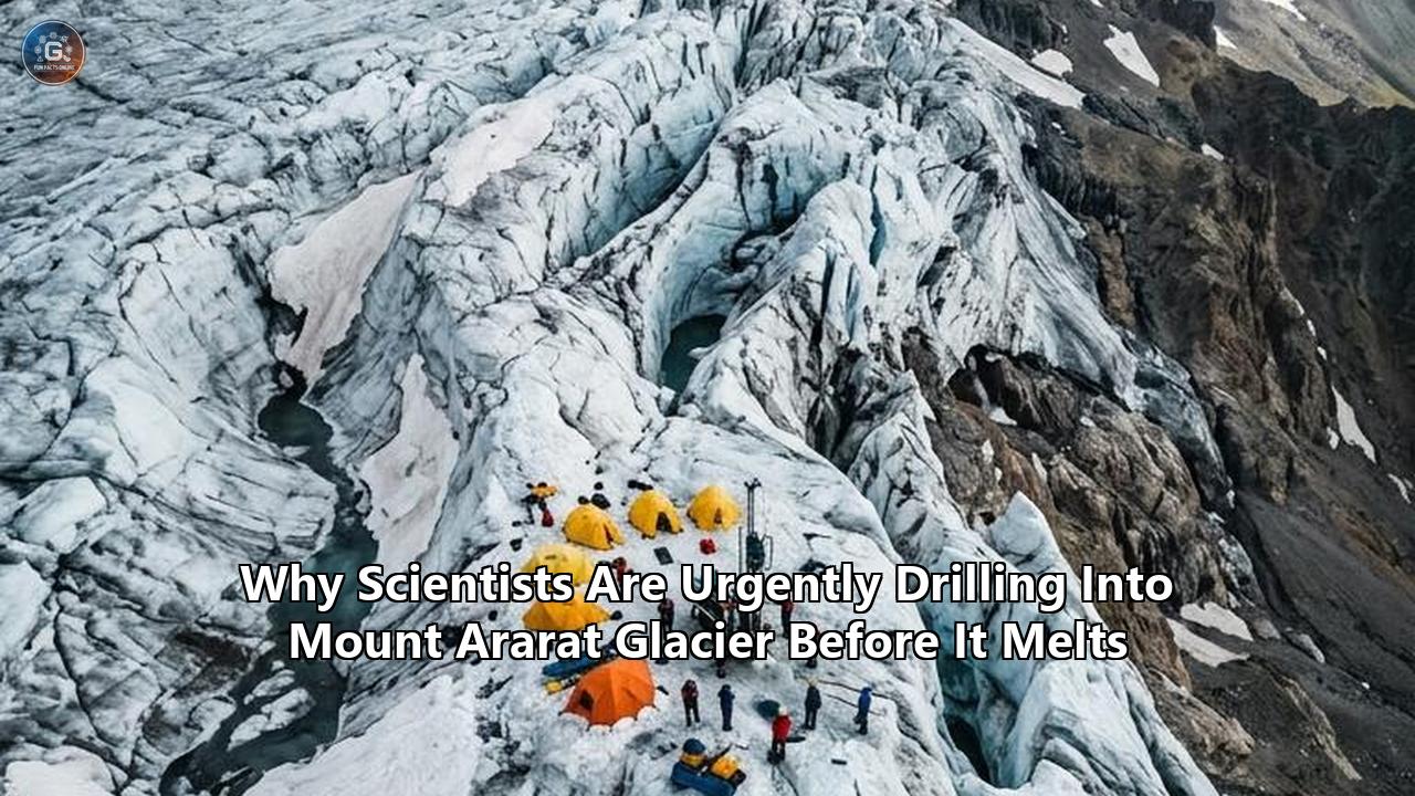
At an elevation exceeding 5,000 meters in the rugged highlands of eastern Turkey, a joint German-Turkish research team completed a critical high-altitude survey on the summit ice cap of Mount Ararat. Operating in sub-zero temperatures with atmospheric oxygen levels at nearly half of those at sea level, glaciologists and archaeologists deployed ground-penetrating radar arrays and active seismic sensors across the glacier’s surface. Their immediate goal was to map the bedrock geometry and internal structure of Turkey’s highest ice mass. Their broader mission is a high-stakes salvage operation: locating the precise coordinates to drill and extract the first continuous ice cores from Mount Ararat before the rapidly disappearing glacier destroys its own historic archive.
Led by project leader Prof. Dr. Achim Lichtenberger from the University of Münster, alongside Prof. Dr. Ünsal Yalçın of Isparta University of Applied Sciences and Dr. Coen Hofstede of the Alfred Wegener Institute, Helmholtz Centre for Polar and Marine Research (AWI), the interdisciplinary team spent two weeks conducting high-resolution geophysical soundings. Mount Ararat—known locally as Ağrı Dağı—stands at a strategic geographical crossroads linking Anatolia, Mesopotamia, and the Caucasus. While polar ice cores in Greenland and Antarctica record hemispheric atmospheric conditions over hundreds of thousands of years, the summit glacier of Mount Ararat contains a localized, high-resolution record of the environmental conditions that accompanied the birth and development of early human civilization.
The window to retrieve these ice cores is rapidly closing. Surface melting driven by rising global temperatures is no longer merely reducing the physical mass of the glacier; it is actively scrambling the geochemical layers within. When meltwater trickles down through the ice, it washes away soluble chemical markers, alters water isotope ratios, and homogenizes historical strata. Glaciologists now recognize that Mount Ararat glacier melting has reached a critical tipping point where decades of environmental, agricultural, and industrial history are being erased every summer.
The Geochemical Vault Overlooking the Fertile Crescent
To understand why scientists are risking severe altitude sickness, frostbite, and logistical failures to drill into Mount Ararat, one must look at the mountain's geographical position. Rising to 5,137 meters above sea level, the dormant stratovolcano towers over the upper reaches of the Aras and Murat rivers. It sits immediately adjacent to the Fertile Crescent—the historic cradle of agriculture, early metallurgy, and ancient urban centers.
                 [ Mount Ararat Ice Cap (5,137m) ]
                                |
       +------------------------+------------------------+
       |                                                 |
  Glaciological Record                             Archaeological Record
  • Past atmosphere composition                    • Early metal smelting dust (Pb, Cu)
  • Stable isotope ratios (δ18O, δD)               • Slash-and-burn charcoal particles
  • Regional volcanic ash layers                   • Pollen from crop cultivation
  • Dust transport & drought cycles                • Traces of ancient warfare & fire
For decades, archaeologists studying the ancient Near East have relied almost exclusively on terrestrial soil strata, sediment cores from lakes, and archaeological excavations. While rich in cultural artifacts, terrestrial soil deposits are inherently discontinuous. Soil erosion, bioturbation, agricultural plowing, and historical construction frequently disrupt soil layers, leaving gaps in the environmental timeline.
Glacial ice offers an entirely different medium. Snow falling on the upper slopes of Mount Ararat traps atmospheric aerosols, windblown dust, micro-charcoal, pollen, and volcanic ash. As winter snow turns to firn and eventually compresses into solid glacial ice, it seals these atmospheric impurities into chronological layers.
"For archaeology, an entirely new source is opening up here," says Prof. Dr. Achim Lichtenberger. "So far, we have been dependent on what lies in the ground. The ice, by contrast, could preserve a continuous chronicle of human activity, layer by layer over millennia."
Among the most prized targets for the research team are heavy metal aerosols generated by early human industrial activity. The Anatolian peninsula and the nearby Caucasus mountains were early centers of pyrometallurgy, where human societies first mastered the extraction and smelting of copper, lead, silver, and iron. Ancient smelting furnaces released aerosolized metal particles high into the atmosphere, which were subsequently transported by regional winds and deposited on the summit snows of Mount Ararat.
Prof. Dr. Ünsal Yalçın highlights the potential to track human technological development through ice chemistry: "If we are lucky, we will find in the ice not only climate data but also fine metal particles from ancient smelting furnaces or residues from early slash-and-burn agriculture. Mount Ararat would then serve as an archive for the entire region of Anatolia, Mesopotamia and the Caucasus."
By measuring trace element ratios—specifically lead isotope signatures ($^{206}\text{Pb}/^{207}\text{Pb}$ and $^{208}\text{Pb}/^{206}\text{Pb}$)—analytical geochemists can trace atmospheric emissions back to specific ancient mining districts. This capability could allow researchers to construct a quantitative timeline of metal production across the Bronze and Iron Ages, tracking the rise and fall of regional empires, economic trade networks, and wartime industrial surges.
Historical Atmospheric Tracers in Ararat Ice
┌───────────────────────┬──────────────────────────────────────────────────────────────┐
│ Aerosol / Proxy Target│ Scientific & Historical Significance                         │
├───────────────────────┼──────────────────────────────────────────────────────────────┤
│ Lead & Copper Dust    │ Reconstructs ancient metallurgy, smelting output, mine sites │
│ Micro-charcoal        │ Tracks slash-and-burn clearing, regional forest fires        │
│ Pollen Grains         │ Documents agricultural evolution, crop choice, vegetation     │
│ Cryptotephra          │ Pinpoints volcanic eruptions for precise calendar dating     │
│ Water Isotopes (δ18O) │ Yields ambient temperature proxies across climate anomalies  │
└───────────────────────┴──────────────────────────────────────────────────────────────┘
Furthermore, the ice cap retains physical proxies for regional climate fluctuations. Major climatic anomalies—such as the Akkadian Empire collapse around 2200 BCE (often linked to severe multi-century drought), the Roman Climate Optimum, and the Late Antique Little Ice Age (LALIA) of the 6th century CE—exerted massive pressures on ancient Middle Eastern civilizations. High-resolution stable isotope profiles ($\delta^{18}\text{O}$ and $\delta\text{D}$) extracted from Mount Ararat's ice will allow glaciologists to determine local temperature and precipitation variations during these historical inflection points, separating natural climate stress from anthropogenic collapse.
The Physics of Degradation: Why the Window Is Closing
The urgency behind the summer expedition stems from a brutal glaciological reality: Mount Ararat is losing its ice cap at an accelerating rate, and the process destroys the scientific record long before the ice physically disappears.
               PROCESS OF GLACIAL ARCHIVE DEGRADATION

     [ Rising Ambient Temperature & Solar Radiation ]
                            │
                            ▼
               [ Surface Snow/Firn Melting ]
                            │
                            ▼
      [ Liquid Meltwater Percolates Downward into Ice ]
                            │
            +---------------+---------------+
            │                               │
            ▼                               ▼
 [ Soluble Ions Washed Away ]    [ Isotopic Signals Smoothed ]
 (Nitrates, Sulfates, Chlorides)  (δ18O and δD Homogenization)
            │                               │
            +---------------+---------------+
                            │
                            ▼
          [ Chronological Stratigraphy Scrambled ]
          (Irreversible Loss of Historical Data)
Remote sensing data and satellite imagery document a stark trend. In the late 1950s, glaciological observations recorded an ice cap covering roughly 10 square kilometers, with 11 prominent outlet glaciers descending down the volcanic slopes to elevations of 3,900 meters on the northern flank. A landmark remote sensing study led by Turkish glaciologist Mehmet Akif Sarıkaya revealed that between 1976 and 2011, the summit ice cap contracted from 8.0 square kilometers down to 5.7 square kilometers—a total surface area reduction of 29 percent in just 35 years.
Recent satellite surveys confirm that Mount Ararat glacier melting has continued to accelerate, pushing the lower boundary of permanent ice higher up the peak and reducing the remaining ice cap to under 5 square kilometers.
However, the reduction in surface area is only the visible symptom of a more destructive process occurring within the glacier’s internal structure: thermal degradation via meltwater percolation.
In a cold glacier—where internal temperatures remain well below freezing year-round—annual layers of snowfall remain isolated. Snow converts gradually into firn (granular, partially compacted snow) and then into solid ice under the pressure of overlying layers. Bubbles of atmospheric gas are trapped intact, and chemical impurities remain locked at the exact horizon where they fell.
When summer ambient temperatures rise above freezing, surface meltwater forms. This liquid water does not simply run off the mountain; it percolates downward through the porous firn layer. As meltwater travels down through colder ice, several destructive mechanisms occur:
- Chemical Elution: Highly soluble ions—such as nitrate ($\text{NO}_3^-$), sulfate ($\text{SO}_4^{2-}$), chloride ($\text{Cl}^-$), and sodium ($\text{Na}^+$)—are preferentially dissolved by percolating water and flushed downward into lower layers. This disrupts the chemical concentration profiles used to identify annual seasonal layers.
- Isotopic Smoothing: Stable isotopes of hydrogen and oxygen ($\delta^{18}\text{O}$ and $\delta\text{D}$) serve as paleothermometers. Higher ratios correspond to warmer conditions, and lower ratios represent colder conditions. Meltwater percolation causes isotopic exchange between liquid water and solid ice crystals, smoothing out seasonal cycles and erasing high-frequency climate signals.
- Pore-Space Refreezing and Thermal Contamination: When percolating water hits colder, deeper ice, it refreezes into thin ice lenses. This process releases latent heat into the surrounding ice matrix, warming the deep glacier from the inside out and accelerating the firn-to-ice transition phase while trapping modern atmospheric air in ancient horizons.
Once thermal degradation affects a glacier, the chronological stratigraphy becomes irreversibly scrambled. Glaciologists refer to this as a "compromised archive." On Mount Ararat, summer surface melting is creeping higher up the summit dome each year. The current survey was specifically timed to locate cold ice reservoirs where deep layers remain cold enough to have escaped complete meltwater degradation.
Mapping the Subglacial Bed: Seismics and Radio Echo Sounding
Before heavy drilling hardware can be brought up a 5,000-meter peak, researchers must know exactly where to drill. Drilling blindly risks striking shallow bedrock, hitting internal shear zones that distort ice layers, or selecting a spot where geothermal heat from Mount Ararat’s volcanic core has melted the bottom-most—and oldest—layers of ice.
            SUMMIT ICE CAP GEOPHYSICAL SURVEY SETUP

   [ Radar Transmitter ]                 [ Active Seismic Setup ]
            │                                       │
  Radio Echo Sounding (RES)              Controlled Shock Impulse
  (10–100 MHz EM Waves)                 (Acoustic Pressure Waves)
            │                                       │
            ▼                                       ▼
   Ice Layer Reflections                   P-Wave Bedrock Reflection
            │                                       │
            +-------------------+-------------------+
                                │
                                ▼
                   Bedrock Depth & Geometry Map
                    (Optimal Borehole Selection)
During the July expedition, Dr. Coen Hofstede and the AWI geophysical team deployed a dual-sensing methodology combining ground-based Radio Echo Sounding (RES) with active seismic profiling.
Radio Echo Sounding (RES)
Radio Echo Sounding operates by transmitting high-frequency electromagnetic pulses (typically between 10 MHz and 100 MHz) into the glacier. As these electromagnetic waves travel through the ice at roughly 168 meters per microsecond, they encounter dielectric contrasts. These contrasts occur at internal dust layers, volcanic tephra horizons, density transitions between firn and ice, and ultimately at the subglacial bedrock boundary.
By recording two-way travel times of the reflected radar signals, glaciologists construct two-dimensional cross-sections (radargrams) of the glacier’s interior. These radargrams reveal:
- Total ice thickness across the summit ice cap.
- Internal folding or structural disruptions caused by glacial flow.
- The location of internal liquid water pockets or englacial channels.
However, radar imaging faces unique limitations on volcanic glaciers like Ararat. Volcanic ice often contains high concentrations of light-scattering ash layers and liquid water pockets, which can attenuate radar signals and obscure the bedrock echo.
Active Seismic Profiling
To resolve ambiguities in the radar data, the team paired RES with active seismics. This technique involves generating controlled acoustic pressure waves at the surface—using mechanical impact hammers or small explosive impulses—and recording the returning seismic waves using an array of geophones planted directly into the hard firn.
Seismic P-waves travel through polycrystalline ice at roughly 3,800 meters per second. Because acoustic waves interact with the mechanical elastic properties of ice and rock rather than dielectric properties, seismic reflections penetrate deep through wet or ash-laden ice that might block radar signals.
The combined RES-seismic dataset allowed the team to map the precise three-dimensional geometry of the bedrock beneath Mount Ararat’s ice cap.
"Despite wind and cold, we obtained all the data we need," says Dr. Coen Hofstede. "Now we can determine where to drill the longest continuous ice core."
By identifying subglacial depressions or localized bedrock hollows where ice is thickest and movement is minimal, the team pinpointed targets where the oldest ice accumulates without being sheared away by gravity-driven ice flow.
High-Altitude Physical and Logistical Operations
Conducting high-precision geophysics above 5,000 meters presents severe operational challenges. High-altitude glaciology requires balancing extreme physical demands with delicate electronic instrumentation.
                 OPERATIONAL ALTITUDE PROFILE
 5,137m ─── Summit Cap: Geophysical Survey & Borehole Extraction Site
            • 50% Atmospheric Oxygen relative to Sea Level
            • Sub-Zero Wind Chill & Severe Thermal Stress on Gear
 4,200m ─── High Camp: Equipment Staging & Acclimatization
            • Limit of Upper Vegetation / Moraine Zone
 3,200m ─── Base Camp: Pack Animal & Horse Transport Cutoff
            • Initial Equipment Assembly & Gear Inspection
 2,000m ─── Valley Logistics Hub (Doğubayazıt)
            • High-Ambient Heat Zone (>30°C in Summer)
Extreme Environmental Conditions
At 5,000 meters, barometric pressure drops to approximately 540 hPa, meaning oxygen availability is roughly half that at sea level. Field crew members experience rapid physical exhaustion, severe headaches, and reduced cognitive performance, demanding strict acclimatization schedules before undertaking technical tasks.
Extreme cold and wind chills further complicate field operations. High-speed wind gusts (frequently reaching 70–80 km/h) can destabilize radar antennae and knock over scientific gear.
Temperature fluctuations also create severe challenges for electronics. Standard lithium-ion battery packs lose output capacity when exposed to sub-zero high-altitude environments. The team had to build custom insulated thermal enclosures equipped with internal heating elements to keep radar electronics, seismic recorders, and GPS positioning systems functioning.
Geopolitical and Military Logistics
Mount Ararat is not simply an environmental research site; it is a sensitive geopolitical border zone. Located in the far eastern Ağrı Province of Turkey, the mountain sits near the tri-border region of Turkey, Iran, Armenia, and the Nakhchivan exclave of Azerbaijan.
                  GEOPOLITICAL ENVIRONMENT

                    [ ARMENIA ]
                         │
                         │ (Border)
                         ▼
  [ TURKEY ] ───► [ Mount Ararat ] ◄─── [ IRAN ]
    (Ağrı)               ▲
                         │ (Border)
                         │
                  [ NAKHCHIVAN (AZERBAIJAN) ]
Because of historical regional tensions, border security, and past security restrictions, accessing Mount Ararat requires special high-altitude military clearances, official research permits from national authorities, and local military escorts. Securing these permits demands months of diplomatic coordination between international research universities, national Ministries of Culture and Tourism, and defense agencies.
Heavy Gear Transport
Moving scientific equipment to the summit involves a multi-stage logistics chain:
- Valley Hub (Doğubayazıt): Equipment is cataloged, tested, and prepped in the valley.
- Base Camp (approx. 3,200 meters): Gear is carried up to base camp using pack horses and local porters along steep volcanic trails.
- High Camp (approx. 4,200 meters): Horses can no longer navigate the steep moraine fields, loose scree, and ice margins. Gear must be hand-carried by mountain guides or hoisted using specialized winch systems.
- Summit Ice Dome (5,000+ meters): Final transport across snowfields requires high-altitude sledges dragged by researchers on crampons.
For the extraction campaign, transporting heavy drilling rigs, generators, power cables, fuel, and vacuum-insulated storage containers requires dedicated high-altitude helicopter support or specialized lightweight electromechanical drill systems designed to be dismantled into 20-kilogram modules.
Drilling Technology and the Cold-Chain Preservation Problem
Retrieving an ice core from a high-altitude summit glacier is only half the battle. Transporting delicate ice samples down a hot mountain valley without allowing them to melt or degrade chemically requires precise thermal logistics.
                  ICE CORE COLD-CHAIN LOGISTICS

 [ Surface Borehole Extraction ] ──► Electromechanical Barrel Drill
                │
                ▼
 [ Field Logging & Packaging ] ─► Polyethylene Sleeve & Aluminum Foil
                │
                ▼
 [ Thermal Stabilization ] ──────► High-Altitude Sub-Zero Storage Pit
                │
                ▼
 [ Downward Transit ] ───────────► Sledges to High Camp ──► Pack Transport
                │
                ▼
 [ Cold Chain Transport ] ───────► Refrigerated Truck (-25°C) in Valley
                │
                ▼
 [ Deep Freeze Archive ] ────────► Long-term Cold Storage Laboratory
Electromechanical Drilling Technology
To extract core segments, glaciologists rely on lightweight electromechanical drills. The drill consists of a rotating cylindrical barrel equipped with sharp carbide or diamond-tipped cutters at its lower lip. As the barrel rotates, it cuts an annular ring around a central column of ice.
- Dry Drilling: Unlike deep polar drilling projects (such as the Beyond EPICA project in Antarctica) that fill boreholes with synthetic drilling fluids to prevent hole closure at depths of 2,000+ meters, high-altitude alpine drilling is typically conducted "dry".
- Core Barrel Retrieval: Once the core barrel fills with ice (typically in 1-meter to 1.5-meter segments), a spring-loaded mechanical catch snaps the bottom of the ice core. The drill string is winched up to the surface, and the ice segment is pushed out.
Dry Electromechanical Drill Barrel Design
┌──────────────────────────────────────────────────────────────┐
│  [ Electric Motor ] ──► [ Planetary Gearbox ]                │
│                                │                             │
│                                ▼                             │
│  [ Outer Non-Rotating Barrel ] / [ Inner Rotating Barrel ]   │
│                                │                             │
│                                ▼                             │
│  [ Core Catchers ] ──► [ Carbide/Diamond Cutting Teeth ]     │
└──────────────────────────────────────────────────────────────┘
The primary engineering challenge on Mount Ararat is preventing the drill from binding. In ice near its pressure melting point (0°C), friction generated by the cutting head creates a thin film of water. This liquid water can refreeze instantly around the drill head, jamming the assembly inside the borehole. Operators must carefully adjust rotational speed, cutter pitch, and penetration rates to minimize thermal friction.
Maintaining the Cold Chain
Once extracted, the ice core enters a strict thermal preservation protocol:
- Core Processing on the Ice: In a field trench dug into the snow surface to shield samples from direct solar radiation, researchers log the core’s depth, inspect it for physical fractures, and photograph structural features like volcanic ash layers or refrozen ice lenses.
- Packaging: The ice cores are wrapped in clean polyethylene sleeves, sealed in airtight protective tubes, and placed inside rigid aluminum boxes lined with Vacuum Insulation Panels (VIPs).
- Phase-Change Thermal Buffering: Phase-Change Material (PCM) packs or dry ice blocks are placed inside the containers to maintain an internal temperature of -20°C or colder, even if ambient external temperatures rise above freezing during transit.
- Valley Transfer: Sledges transport the thermal boxes down to High Camp. From there, specialized porters or pack mules move them down to Base Camp, where they are loaded directly into freezer-equipped vehicles waiting in the valley.
- Lab Transit: The insulated core containers are driven or flown directly to specialized cold-storage facilities in Europe and Turkey, where they remain frozen at -25°C to -30°C until geochemical sampling begins.
Analytical Geochemistry: What the Ararat Cores Will Reveal
Once the ice cores reach ultra-clean laboratory environments, glaciologists and analytical chemists employ advanced micro-analytical tools to decode the environmental record locked inside.
┌─────────────────────────┬──────────────────────────┬────────────────────────────────────────┐
│ Analytical Technique    │ Target Proxy / Component │ Environmental Information Yielded     │
├─────────────────────────┼──────────────────────────┼────────────────────────────────────────┤
│ HR-ICP-MS               │ Heavy metals (Pb, Cu, Cd)│ Industrial history, ancient metallurgy  │
│ Cavity Ring-Down Spec.  │ Stable isotopes (δ18O, δD)│ High-resolution temperature record     │
│ Micro-CT Scanning       │ Bubble structure & density│ Firn compaction & atmospheric pressure │
│ Ion Chromatography      │ Nitrates, sulfates, salts│ Agricultural activity, sea salt cycles │
│ Laser Diffraction       │ Micro-dust particle size │ Drought frequency, wind intensity      │
│ Cryptotephra Extraction │ Volcanic ash shards      │ Exact calendar dating horizons         │
┌─────────────────────────┴──────────────────────────┴────────────────────────────────────────┐
High-Resolution Inductively Coupled Plasma Mass Spectrometry (HR-ICP-MS)
To measure trace metals at parts-per-trillion (ppt) concentrations, continuous core melting systems are paired directly with HR-ICP-MS instruments. As an ice core is slowly melted top-to-bottom on a heated ceramic head, liquid from the clean inner core is pumped straight into the mass spectrometer.
This generates a continuous profile of human metallurgy:
- Copper ($\text{Cu}$) spikes reflect early Chalcolithic and Bronze Age smelting activities in Anatolia and the Caucasus.
- Lead ($\text{Pb}$) concentration peaks map the expansion of silver refining and lead-based smelting during the Hittite, Roman, and Byzantine periods.
- Lead Isotope Ratio Analysis ($^{206}\text{Pb}/^{207}\text{Pb}$ vs $^{208}\text{Pb}/^{206}\text{Pb}$) allows researchers to match lead aerosols trapped in the ice to specific ancient mining sites, such as Taurus Mountain deposits or Caucasian ore fields.
Micro-Charcoal and Black Carbon
Using laser-induced incandescence and optical microscopy, scientists count micro-charcoal particles suspended in the ice. Charcoal concentrations correlate directly with regional biomass burning. High concentrations reveal large-scale forest clearing for early agriculture (slash-and-burn farming) or severe regional wildfires triggered by historic droughts.
Palynology (Pollen Analysis)
Pollen grains preserved in mountain ice cores offer a direct record of past vegetation shifts. Changes in the ratio of tree pollen (e.g., Oak, Pine) to agricultural pollen (e.g., Cerealia, Plantago) document the transformation of the Near Eastern landscape from wild forest-steppe into cultivated farmland.
Cryptotephra Horizons
Volcanic glass shards (cryptotephra) invisible to the naked eye are extracted using chemical filtration and analyzed under Scanning Electron Microscopy (SEM). By determining the precise geochemical fingerprint of the glass shards, geologists can link specific ice layers to known historical volcanic eruptions, such as:
- The Bronze Age eruption of Santorini (Thera).
- Historical eruptions of regional Anatolian volcanoes like Nemrut, Tendürek, or Mount Ararat itself.
These volcanic tephra horizons act as firm chronological marker beds, anchoring the age-depth model of the ice core to absolute calendar years.
Geothermal Heat and Volcanic Baseline Challenges
Mount Ararat presents a unique glaciological complication: it is a stratovolcano. Although its last explosive phreatic eruption occurred on July 2, 1840—accompanied by a magnitude 7.4 earthquake that triggered fatal pyroclastic flows and massive landslides down its northern flank—the underlying magma chamber remains geothermally active.
             VOLCANIC ICE CAP THERMAL STRUCTURE

                  [ Snowfall & Ice Accumulation ]
                                │
                                ▼
                   [ Surface Melt & Firn Layer ]
                                │
                                ▼
                 [ Mid-Depth Cold Ice Reservoir ]  ◄── Target Extraction Zone
                                │
                                ▼
       ~~~~~~~~~~ [ Geothermal Heat Flux Zone ] ~~~~~~~~~~
                                │
                                ▼
           [ Volcanic Bedrock (Basal Thermal Melting) ]
Geothermal heat flux from the volcanic bedrock flows upward into the base of the glacier. This thermal gradient creates two distinct glaciological problems:
- Basal Melting: If geothermal heat flux is sufficiently high, the temperature at the ice-bedrock interface reaches the pressure melting point ($0^\circ\text{C}$). This melts the lowest layers of ice, turning them into liquid basal runoff. Because the oldest ice lies at the very bottom of the core, basal melting can destroy the earliest centuries or millennia of the climate archive.
- Thermal Deformation: Elevated temperatures in the lower third of the glacier make the ice softer and more ductile. Under the immense pressure of the overlying ice cap, warmer deep ice deforms rapidly, stretching or folding internal strata and complicating chronological dating.
Addressing this geothermal challenge was a major objective of the July survey. By mapping bedrock topography using active seismics and measuring heat dissipation variations across the dome, Dr. Coen Hofstede’s team identified specific subglacial ridge zones where bedrock heat flux is minimal, maximizing the chances of recovering intact, cold basal ice.
Global Context: The Ice Memory Sanctuary Initiative
The urgency surrounding Mount Ararat is part of a broader, worldwide effort to salvage high-altitude mountain glaciers before they melt away.
While polar ice sheets in Greenland and Antarctica cover vast regions, non-polar mountain glaciers contain high-resolution environmental archives located directly adjacent to human settlements. Yet tropical and mid-latitude glaciers—from the Andes and the Alps to the Himalayas and the Anatolian highlands—are retreating rapidly. Glaciologists estimate that most mid-latitude glaciers below 5,500 meters altitude could disappear or suffer severe thermal degradation before the end of the 21st century.
                 GLOBAL ICE ARCHIVE PRESERVATION

   Mount Ararat Core Recovery       Global Mountain Glaciers
   (Anatolian / Near East Archive)  (Alps, Andes, Himalayas)
                │                              │
                +──────────────┬───────────────+
                               │
                               ▼
               [ ICE MEMORY FOUNDATION VAULT ]
              (Concordia Station, Antarctica)
                               │
                               ▼
            • Passive Natural Freezing at -50°C
            • Zero Electrical Power Reliance
            • Preserved for Future Generations & Technology
To prevent the permanent loss of these climate archives, international glaciological bodies established the Ice Memory Foundation. The project's goal is to extract twin ice cores from vulnerable mountain glaciers worldwide:
- Core 1 (Immediate Analysis): One core is analyzed immediately using current state-of-the-art geochemical instruments to answer pressing questions about paleoclimate and past atmospheric conditions.
- Core 2 (Long-Term Storage): The second core is transported to a permanent non-polar ice core sanctuary located at Concordia Station on the Antarctic Plateau.
At Dome C in Antarctica, where mean annual temperatures remain below -50°C, the ice cores can be preserved indefinitely without relying on electrical refrigeration. This ensures that future generations of scientists—equipped with advanced analytical technologies yet to be invented—will still be able to study pristine samples from glaciers that have long since melted from Earth's mountain peaks.
The continuous ice core targeting Mount Ararat is a primary candidate for this preservation effort. Retaining a preserved core from the Middle East is vital because no other mountain glacier in the region offers an equivalent altitude and ice depth to store millennia of environmental history.
The Road Ahead: What to Watch for in the Extraction Season
With the geophysical survey completed and bedrock mapping finalized, the German-Turkish scientific consortium is preparing for the extraction phase.
                    PROJECT MILESTONE TIMELINE

  [ July 2026 ] ──────── High-Altitude Geophysical Survey Completed
                         • Bedrock Geometry & Ice Depth Mapped
                         • Radio Echo Sounding & Active Seismics Finalized

  [ Upcoming Phase ] ─── Deep Drilling & Core Extraction Campaign
                         • Transport of Electromechanical Barrel Drills
                         • High-Altitude Extraction above 5,000m

  [ Post-Extraction ] ── Cold-Chain Transit & Geochemical Analysis
                         • HR-ICP-MS Heavy Metal Aerosol Profiling
                         • Isotopic & Palynological Layer Sequencing
                         • Deposition of Archive Core into Ice Memory Vault
As the team transitions from geophysical surveying to deep core extraction, several key developments will determine the success of the mission:
- Borehole Site Selection: The research team will finalize the primary borehole coordinates based on internal ice stratification identified in the radargrams. The ideal site requires maximum ice thickness combined with minimal flow-induced folding and negligible basal melting.
- Drilling Season Window: Deep core drilling can only take place during a brief operational window. The team must balance spring weather conditions (frequent high-altitude blizzards, avalanche risks) against late-summer heat (increased surface meltwater risk, drill binding hazards).
- Age-Depth Verification: Once the first continuous core is retrieved, initial micro-CT scanning and tephra analysis will establish a baseline age-depth model. Glaciologists are waiting to see whether the core reaches back into the early Holocene or even the late Pleistocene transition.
- Geochemical Insights: Initial analytical runs will focus on identifying trace metal signatures from early Bronze Age metal production. Discovering clear lead and copper concentrations linked to early Mesopotamian and Caucasian furnace technologies will prove that Mount Ararat preserves an continuous industrial history of early civilization.
The race to drill Mount Ararat represents a major convergence of modern glaciology, classical archaeology, and environmental politics. As global temperatures continue to rise, the summit ice cap of Ağrı Dağı is fading fast. By extracting this high-altitude archive, researchers are racing to rescue a delicate, unwritten record of human and planetary history before it turns to water and vanishes down the mountain.
Reference:
- https://phys.org/visualstories/2026-07-experts-survey-glacier-ice-mount.amp
- https://www.uni-muenster.de/news/view.php?cmdid=15580
- https://www.noahsarkscans.com/mount-ararat
- https://www.antarctica.gov.au/science/climate-processes-and-change/antarctic-palaeoclimate/million-year-ice-core/
- https://www.bas.ac.uk/news/historic-drilling-campaign-reaches-ice-more-than-1-2-million-years-old/
- https://en.wikipedia.org/wiki/Mount_Ararat
- https://eros.usgs.gov/earthshots/rbv-images-mount-ararat
- https://www.climberscience.org/ararat
- https://worldexpeditions.com/Tuerkiye/Turkey/Trekking-Walking/Mount-Ararat-Expedition
- https://www.intechopen.com/chapters/1181021