California motor vehicle regulators have barred Waymo from operating its driverless robotaxis on all state freeways, citing an "imminent hazard to public safety" after multiple autonomous vehicles drove into active highway work zones and attempted to bypass California Highway Patrol vehicles.
The operational restriction, issued by the California Department of Motor Vehicles (DMV) on November 11, 2026, and made public on Tuesday, halts Waymo’s high-speed autonomous service across the state. The state's action immediately prompted the Alphabet-owned company to voluntarily suspend freeway operations across its other national markets—including Phoenix, Austin, and Miami—while it re-evaluates its software.
“The Department determined that Waymo’s driverless freeway operations pose an imminent hazard to public safety due to recurring incursions by its vehicles into active construction zones where construction workers, vehicles and equipment are present,” California DMV spokesperson Jonathan Groveman said in a statement detailing the enforcement action.
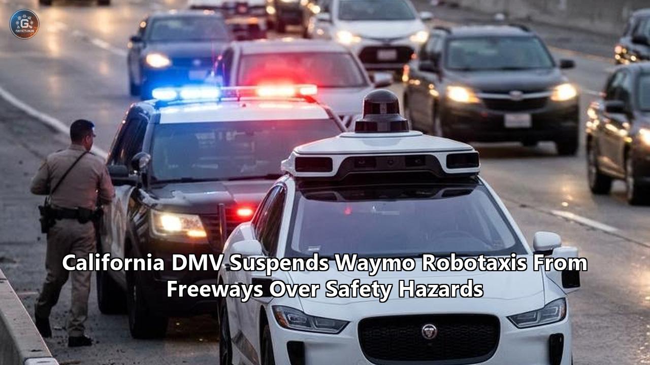
The regulatory intervention was triggered by two incidents in the San Francisco Bay Area. On November 5, three separate driverless Waymo vehicles entered an active freeway construction closure on U.S. Route 101 near Burlingame, navigating past closure warnings into lanes occupied by maintenance crews and heavy machinery. Days later, video captured a driverless Jaguar I-Pace attempting to pass California Highway Patrol (CHP) cruisers executing a rolling "traffic break" on Interstate 280 in San Francisco, forcing an officer to swerve defensively to block the autonomous car.
Waymo complied with the state mandate while pointing out that the incidents produced no collisions or physical injuries.
“In alignment with our safety-first principles, we have also temporarily restricted freeway operations across our other operating markets to evaluate our performance,” Waymo spokesperson Dana Gallagher said in an emailed statement. “Our ride-hailing service continues to operate safely on surface streets, serving over half a million trips each week. We are working with the California DMV and other state officials diligently and responsibly to resume freeway operations.”
The suspension marks the most consequential regulatory setback for autonomous vehicles in California since the state revoked GM Cruise’s testing and deployment permits in late 2023. While Waymo retains its authorization to carry paying passengers on local surface streets, stripping freeway access removes the critical high-speed transit corridors that make metropolitan commercial robotaxi services viable. The move raises fresh scrutiny over Waymo robotaxi safety as the company attempts to transition from urban street navigation to high-speed highway mobility.
Understanding why driverless vehicles struggle with freeway work zones and emergency vehicles requires looking past the regulatory headlines into the complex mechanics of autonomous perception, the limits of digital maps, and the sheer physics of high-speed transit.
Anatomy of the Incidents: Highway 101 and Interstate 280
The DMV's emergency order was not a reaction to a single software bug, but the culmination of a recurring failure mode that Waymo had previously pledged to fix.
Waymo Highway Incidents & Regulatory Timeline (2026)
┌────────────────────────────────────────────────────────────────────────┐
│ May 18: Multiple robotaxis breach S.F. construction zones              │
│   └─► Waymo self-suspends freeway testing; recalls ~3,900 vehicles     │
│ July 29: Waymo deploys software patch, gradually restores freeways     │
│ Nov 5: Three driverless cabs enter active U.S. 101 work zone           │
│ Nov 6–11: Robotaxi attempts to overtake CHP traffic break on I-280     │
│ Nov 11: California DMV issues emergency operational restriction        │
│ Nov 17: Order made public; Waymo pauses freeways nationwide            │
└────────────────────────────────────────────────────────────────────────┘
On May 18, 2026, seven Waymo vehicles drove past traffic cones and into closed lanes in San Francisco. That failure led the company to temporarily pause public freeway operations and file a voluntary safety recall with the National Highway Traffic Safety Administration (NHTSA) in June covering nearly 3,900 vehicles. Waymo pushed over-the-air updates designed to improve how its automated driving system identifies roadwork equipment and ramp closures. By late July, the company began phasing freeway trips back into its commercial service.
The November incidents demonstrated that the software patches had not solved the underlying problem.
On U.S. 101 in Burlingame, Caltrans contractors had established an active lane closure marked by illuminated arrow boards, reflective traffic drums, and tapering cone patterns to protect highway workers. Despite these warnings, three driverless Waymo cabs consecutively entered the buffer zone. Maintenance crews were forced to actively monitor the perimeter as driverless vehicles moved into their workspace.
The Interstate 280 encounter posed a different hazard. Two marked CHP patrol vehicles were performing a tactical traffic break—a standard law enforcement procedure where officers activate emergency lights and weave laterally across all travel lanes at reduced speeds to hold back traffic while crews clear hazards downroad. Dashcam footage showed a Waymo robotaxi interpreting the patrol car’s swerving as an erratic obstacle rather than an authoritative command to stop. The robotaxi shifted into the far-left lane and attempted to pass the police vehicle on the inside, prompting the CHP officer to swerve sharply across the lane to physically cut off the autonomous car.
For state regulators, these two events represented a direct threat to roadway workers and emergency responders. The DMV determined that Waymo had exhausted its leeway for unmonitored highway testing until it could demonstrate a measurable correction.
The Physics of Speed: Why Freeways Break Urban AI Models
A common assumption in autonomous vehicle development was that freeways would prove easier to solve than dense city centers. Urban neighborhoods present a chaotic environment filled with pedestrians, e-scooters, cyclists, double-parked delivery vans, and erratic pets. Freeways, by contrast, lack cross-traffic, pedestrians, and intersections; vehicles travel in predictable directions within defined lanes.
In practice, high-speed corridors trade visual chaos for severe physical constraints. The fundamental challenge of highway autonomous driving is that higher velocities drastically compress computational reaction times while expanding the physical distance required to bring a vehicle to a stop.
The Compressing Latency Budget
At urban speeds of 25 mph, a vehicle travels roughly 36.7 feet per second. If an autonomous driving system takes 300 milliseconds to perceive an obstruction, classify it, predict its motion, and command the brakes, the car covers just 11 feet before deceleration begins.
At a freeway speed of 70 mph, the vehicle covers 102.7 feet every single second:
$$\text{Distance per second} = 70 \text{ mph} \times \left(\frac{5280 \text{ ft}}{3600 \text{ sec}}\right) \approx 102.7 \text{ ft/sec}$$
A 300-millisecond perception and planning lag now translates to more than 30 feet of blind forward travel. Kinetic energy scales with the square of velocity:
$$E_k = \frac{1}{2}mv^2$$
Because kinetic energy quadruples when speed doubles, a passenger vehicle traveling at 70 mph requires roughly 245 to 300 feet of clear pavement to come to a controlled, complete stop under ideal braking conditions.
Speed vs. Stopping Distance Dynamics
┌──────────┬─────────────────┬───────────────────┬───────────────────────┐
│ Velocity │ Feet per Second │ 300ms System Lag  │ Total Stopping Dist.* │
├──────────┼─────────────────┼───────────────────┼───────────────────────┤
│  25 mph  │     36.7 ft     │      11.0 ft      │      ~55–65 ft        │
│  45 mph  │     66.0 ft     │      19.8 ft      │     ~135–155 ft       │
│  70 mph  │    102.7 ft     │      30.8 ft      │     ~280–320 ft       │
└──────────┴─────────────────┴───────────────────┴───────────────────────┘
*Includes perception reaction distance plus mechanical braking distance on dry asphalt.
In urban driving, if a robotaxi’s perception stack encounters an ambiguous visual scene—such as a confusing construction setup or an unexpected cone—the system can execute a "safe stop" or slowly inch forward at 3 mph while re-evaluating. On an interstate highway, stopping dead in a live lane or slowing unpredictably risks triggering a multi-vehicle pileup with fast-approaching commercial semi-trucks and passenger cars.
Every detection, classification, and planning decision on a freeway must be executed hundreds of meters in advance, leaving virtually zero margin for sensor misinterpretation.
Sensor Resolution and the Problem of Distant Geometry
Waymo’s driverless fleet relies on an array of sensors that form the foundation of its driving software:
- Lidar (Light Detection and Ranging): Fires millions of laser pulses per second to build a millimeter-precise, three-dimensional point cloud of the car's surroundings.
- Radar: Emits radio waves to measure the range and instantaneous velocity of objects, operating reliably through rain, fog, and dust.
- High-Resolution Optical Cameras: Capture color, texture, and text, identifying lane markings, traffic lights, and construction signage.
At highway distances, these physical sensors encounter real-world range constraints that complicate Waymo robotaxi safety evaluations.
The Highway Sensor Fusion Array
              ┌────────────────────────┐
              │      ROOFTOP POD       │
              │  360° Lidar + Cameras  │
              └───────────┬────────────┘
                          │
     ┌────────────────────┼────────────────────┐
     ▼                    ▼                    ▼
┌─────────┐          ┌─────────┐          ┌─────────┐
│  LIDAR  │          │ CAMERAS │          │  RADAR  │
└────┬────┘          └────┬────┘          └────┬────┘
     │ 3D Point Cloud     │ Color & Semantics  │ Velocity & Range
     │ (Sparsity at 200m) │ (Exposure Glare)   │ (Clutter Filtering)
     └────────────────────┼────────────────────┘
                          ▼
            ┌───────────────────────────┐
            │   CENTRAL PERCEPTION AI   │
            │   Resolves Conflicts via  │
            │      Sensor Fusion        │
            └─────────────┬─────────────┘
                          ▼
            ┌───────────────────────────┐
            │   PATH PLANNER & MOTION   │
            │ Controls Steering/Braking │
            └───────────────────────────┘
Lidar pulse intensity decays according to the inverse-square law. A target located 20 meters away returns thousands of dense data points, allowing the system to instantly classify a construction drum. At 180 to 200 meters—the distance an autonomous car must scan to plan high-speed maneuvers—that same traffic drum might return only two or three discrete laser points. Those sparse points can easily be discarded as ground clutter or atmospheric noise.
Cameras bridge this gap by identifying colors and shapes, but highway work zones present severe optical challenges. Retroreflective construction tape, high-intensity LED strobe lights on work trucks, and portable electronic arrow boards create optical bloom, momentarily blinding digital camera sensors.
Radar provides precise velocity data, but stationary objects pose an engineering dilemma known as radar clutter. Overhead highway signs, metal bridge expansion joints, and guardrails return strong radar signatures. To prevent vehicles from slamming on their brakes at every overhead sign—an issue known as "phantom braking"—autonomous driving pipelines often filter out static radar returns unless verified by lidar or cameras.
When a Caltrans crew sets up an arrow board and steel barrier trucks in a closed freeway lane, the vehicle's radar sees a large static metallic object, but its filtering algorithms demand visual or lidar confirmation before reacting. If sun glare or flashing lights degrade the camera's feed at the exact moment the lidar points thin out, the perception stack experiences an information bottleneck.
The Map Invalidation Paradox
The technical root of Waymo’s construction zone incursions lies in how the vehicle balances static memory against real-time perception.
Unlike human drivers, who navigate unfamiliar roads entirely on the fly, Waymo’s autonomous system relies heavily on High-Definition (HD) maps. Prior to deploying in any city, Waymo drives specialized mapping vehicles across every street to build a dense, centimeter-accurate 3D digital model. This digital blueprint records:
- Exact lane geometries and boundaries
- Curb heights and road crown angles
- Fixed speed limits and highway exit coordinates
- Locations of overhead gantry signs, guardrails, and lane divider striping
When a Waymo robotaxi travels down a highway, it constantly compares its real-time sensor streams against this stored HD map. This spatial prior allows the car’s computers to localize themselves with high precision and anticipate road curves well before sensors can physically see them.
Active freeway construction zones upend this system. Highway maintenance crews deliberately invalidate the map:
- They paint over existing white and yellow lane stripes with black masking paint (which often wears away or reflects headlights, creating "ghost stripes").
- They lay down temporary, non-standard lane markers that route traffic across paved shoulders or into opposing lanes.
- They drop rows of orange cones or low-profile concrete barriers that cut diagonally across what the HD map records as a valid, high-speed travel lane.
This creates the Map Invalidation Paradox. The vehicle's internal software must resolve a fundamental conflict between two data sources: its pre-compiled map (which claims the lane is open and safe for 65 mph transit) and its real-time sensors (which detect a series of small, ambiguous orange cylinders standing across the lane).
If the machine learning model is tuned to prioritize dynamic sensor inputs, it risks reacting erratically to paper bags, debris, or shadows, triggering dangerous highway stops. If it is tuned to prioritize its pre-mapped lane geometry, it treats the cones as low-confidence anomalies and cruises along its mapped path—driving straight through the taper into active construction sites.
In the U.S. 101 incident, the vehicle's path planner appears to have favored its static map data over the transient construction boundaries, treating closed lanes as viable roadway.
Why AI Struggles With Law Enforcement and Highway Patrol Breaks
The Interstate 280 incident exposed a parallel flaw in autonomous driving architecture: the inability to interpret human intent and social communication on the road.
A California Highway Patrol traffic break is an improvised, non-verbal negotiation between human beings. When an officer engages rear emergency lighting and initiates a serpentine maneuver—swerving across all four or five lanes of a freeway at 30 mph—human drivers immediately grasp the underlying message: The road ahead is blocked; do not pass me.
CHP Traffic Break vs. Robotaxi Logic
┌────────────────────────────────────────────────────────────────────────┐
│ Human Driver Perception:                                               │
│  [CHP Cruiser Swerving with Strobes]                                  │
│   └──► Context: "An emergency is ahead. Stay behind the officer."     │
│   └──► Action: Match speed, hold lane, wait for patrol car to exit.    │
├────────────────────────────────────────────────────────────────────────┤
│ Autonomous Driving System Perception:                                  │
│  [Bounding Box #412: Velocity 32 mph, Heading Variances ±14°]          │
│   └──► Context: "Erratic, slow obstacle drifting across lanes."        │
│   └──► Path Optimizer: "Left lane is open. Speed limit is 65 mph."     │
│   └──► Action: Change lanes, accelerate, attempt an overtake.          │
└────────────────────────────────────────────────────────────────────────┘
The autonomous driving stack analyzes the roadway as an optimization problem. Its perception neural networks detect the police cruiser as a dynamic obstacle. The system computes the cruiser’s bounding box, position, velocity, and trajectory.
To the motion planner, the patrol car simply registered as a slow-moving vehicle drifting unpredictably between center lanes. The vehicle's route planning software, designed to maintain target traffic speeds and seek open paths, observed clear asphalt in the left lane.
Because the system lacked the semantic reasoning to understand that an emergency vehicle’s lateral weaving was an active legal command directed at all trailing cars, the planner calculated that overtaking the slow obstacle in the open left lane was an optimal, collision-free maneuver.
This disconnect demonstrates why Waymo robotaxi safety remains an active challenge when machines encounter authoritative human signaling. Autonomous systems excel at reading static traffic lights, posted speed signs, and standard lane dividers. They struggle when encountering non-standard, dynamic social interactions—such as hand gestures from a construction flagger, a police officer waving drivers through a red light, or a patrol vehicle physically blocking traffic.
The Regulatory Framework: Operational Design Domains
To evaluate the California DMV’s decision, it is necessary to understand how autonomous vehicles are legally sanctioned to operate. Autonomous testing and deployment are governed by a framework created by the Society of Automotive Engineers (SAE) and codified into state law under California Code of Regulations (Title 13, Division 1, Chapter 1).
Autonomous vehicles do not receive blanket driver's licenses. Instead, permits are granted for a precisely defined Operational Design Domain (ODD). The ODD outlines the specific boundary conditions within which the driverless system is certified to function safely:
- Geographic Boundaries: Geofenced municipal limits or specific road networks.
- Environmental Limits: Permitted weather conditions (e.g., clear daylight, light rain; excluding heavy snow or dense fog).
- Speed Ceilings: Surface boulevards up to 35 or 45 mph versus high-speed freeways up to 65 or 75 mph.
Visualizing Waymo's Amputated ODD
┌────────────────────────────────────────────────────────┐
│               PERMITTED URBAN ODD                      │
│  • Surface streets (≤ 45 mph)                          │
│  • Downtown urban cores & suburban neighborhoods       │
│  • City signalized intersections                       │
│  • Complex pedestrian crossings                        │
├────────────────────────────────────────────────────────┤
│          SUSPENDED FREEWAY ODD (NOV 11, 2026)          │
│  ✖ Interstate highways (I-280, I-80, I-10, I-405)      │
│  ✖ State routes & multi-lane freeways (US-101, SR-520) │
│  ✖ High-speed airport transit corridors                │
│  ✖ Dynamic highway construction work zones             │
└────────────────────────────────────────────────────────┘
In October 2023, when the California DMV sanctioned GM Cruise after one of its robotaxis struck, trapped, and dragged a pedestrian in downtown San Francisco, the agency revoked Cruise's deployment and testing permits entirely. Cruise was grounded across all operational domains, precipitating an organizational crisis and leadership departures.
In Waymo’s case, the DMV executed a targeted operational rollback. The agency did not revoke Waymo’s core autonomous deployment permits, allowing its urban and suburban surface-street business to continue unhindered. Instead, the DMV surgically excised the freeway portion from Waymo’s permitted ODD.
Under state law, when an autonomous vehicle operator demonstrates recurring failures within a specific operational domain, the regulator can deem that specific activity an "imminent hazard". To regain its freeway ODD, Waymo faces explicit regulatory hurdles: it must furnish verifiable empirical data proving its vehicles can reliably detect construction closures, obey manual traffic direction, and yield to law enforcement maneuvers without exception.
The Commercial Blow: Why Robotaxis Cannot Scale on Surface Streets
While preserving surface-street operation prevents an existential shutdown, losing highway access strikes at the commercial viability of autonomous ride-hailing.
The economics of any ride-hailing network depend on two metrics: trip duration and fleet utilization (the percentage of time vehicles spend carrying paying passengers versus sitting in traffic or deadheading).
The Transit Time Penalty
Consider a routine ride-hailing journey from downtown San Francisco to San Francisco International Airport (SFO). Via U.S. Route 101, the 14-mile trip typically takes 18 to 22 minutes outside of peak gridlock.
Restricted entirely to surface boulevards—navigating Mission Street, San Jose Avenue, and El Camino Real—the exact same trip encounters dozens of signalized intersections, school zones, transit buses, and local cross-traffic. The trip duration expands to between 48 and 60 minutes.
Trip Performance Comparison: SF Financial District to SFO
┌──────────────────┬─────────────────┬───────────────────┬───────────────────┐
│ Routing Mode     │ Distance (mi)   │ Est. Travel Time  │ Est. Fare Range   │
├──────────────────┼─────────────────┼───────────────────┼───────────────────┤
│ Freeway (US-101) │    14.2 miles   │    18–24 mins     │     $38–$46       │
│ Surface Streets  │    15.8 miles   │    48–62 mins     │     $55–$70*      │
└──────────────────┴─────────────────┴───────────────────┴───────────────────┘
*Calculated with standard time/distance vehicle depreciation and battery overhead.
In major metro areas like Los Angeles and Phoenix, transit between neighborhoods is structurally designed around the freeway system. Traveling from Santa Monica to downtown Los Angeles via Interstate 10 takes 25 minutes in normal conditions; surface routing via Santa Monica Boulevard or Venice Boulevard can easily exceed an hour.
Fleet Productivity Collapse
When transit times double or triple, a robotaxi network suffers an efficiency drop:
- Reduced Vehicle Turns: A single autonomous cab that once completed 16 to 20 passenger trips per day drops to 8 to 11 trips per day because vehicles are tied up for extended intervals on surface corridors.
- Consumer Abandonment: Passengers choose ride-hailing based on convenience and speed. If a human Uber or Lyft driver can access U.S. 101 or I-10 and reach the airport in 20 minutes, consumer demand for a 50-minute surface-bound robotaxi evaporates.
- Battery Depletion: Stop-and-go driving across urban grids burns disproportionate battery reserves per mile compared to steady-state highway transit, requiring robotaxis to return to depot charging hubs more frequently during revenue hours.
Without freeways, Waymo’s commercial footprint transforms from a comprehensive regional transit network back into a localized neighborhood circulator.
The Path to Reinstatement: What Needs to Change
Waymo cannot regain its freeway privileges with a simple software patch. The DMV’s ruling explicitly cited the failure of Waymo's July 2026 software updates to stop the November incidents, establishing that regulators now demand systemic validation.
To satisfy regulators, several technological and operational updates will be required:
1. Vision-Language Foundation Models for Road Semantics
Autonomous vehicle engineering is shifting away from narrow machine learning models that detect isolated objects (e.g., identifying a cone, a sign, or a car separately) toward large multimodal Foundation Models. These integrated models evaluate the entire driving scene contextually. Instead of processing an erratic patrol car as an obstacle to be routed around, a vision-language driving model understands the visual concept of a rolling road block, synthesizing the flashing emergency lighting, the lateral patrol trajectory, and the trailing traffic into an unequivocal command: hold position.
2. Vehicle-to-Infrastructure (V2I) Digital Work Zones
Relying entirely on optical sensors to detect temporary lane closures at 70 mph remains inherently fragile. State transportation agencies and autonomous vehicle developers are working to deploy standardized digital feeds. Under systems like the Federal Highway Administration’s Work Zone Data Exchange (WZDx), maintenance crews log physical lane closures into real-time digital databases that broadcast directly to autonomous fleets via cellular telemetry, alerting path planners to active lane closures miles before their physical sensors reach the taper.
Future Multi-Layer Work Zone Defense
┌────────────────────────────────────────────────────────────┐
│ Layer 1: Digital V2I Telemetry (WZDx Feeds)                │
│  └── Broadcasts active GPS work-zone closures via API      │
├────────────────────────────────────────────────────────────┤
│ Layer 2: Long-Range Sensor Redundancy                      │
│  └── Forward-facing narrow-aperture cameras & FMCW radar   │
├────────────────────────────────────────────────────────────┤
│ Layer 3: Contextual Scene Comprehension                    │
│  └── End-to-end models trained on emergency gestures & CHP │
└────────────────────────────────────────────────────────────┘
3. Dedicated Emergency and Law Enforcement Interaction Protocols
Autonomous operators must develop deterministic behavioral safeguards that override standard path optimization whenever emergency lights are present. If an autonomous vehicle's sensors detect flashing emergency strobes in its immediate forward path on a freeway, the path planner should default to defensive following logic—prohibiting any lane-change or overtaking maneuvers until the scene has stabilized or human remote-assistance operators confirm it is safe to proceed.
Broader Industry Consequences
California’s decision to remove Waymo from freeways signals a transition in how driverless mobility is overseen. The early era of autonomous vehicle deployment measured safety primarily through aggregate collision rates—a metric where Waymo has consistently outperformed human drivers, reporting an 82% reduction in injury-causing crashes over hundreds of millions of public miles.
State and federal regulators are no longer evaluating Waymo robotaxi safety solely on gross collision counts. Regulators are now focusing on structural predictability, rule compliance, and whether autonomous vehicles can integrate cleanly with human infrastructure, highway workers, and law enforcement.
The freeway grounding removes the leading commercial robotaxi fleet from America's fastest transportation corridors. Until Waymo proves its vehicles can read the subtle visual cues of an active work zone and respect the non-verbal commands of emergency personnel, its vision of high-speed driverless transit will remain confined to city streets.
Reference:
- https://www.kqed.org/news/12110123/hazard-to-public-safety-california-dmv-restricts-waymo-freeway-operations
- https://eletric-vehicles.com/waymo/waymo-suspends-freeway-service-nationwide-following-dmv-order/
- https://laist.com/news/transportation/dmv-suspends-waymos-from-california-freeways-citing-imminent-public-safety-hazards
- https://mashable.com/tech/waymo-freeway-rides-safety-california-dmv-ban
- https://www.businessinsider.com/waymo-freeway-operations-banned-california-dmv-construction-zone-closure-2026-11
- https://www.sfgate.com/tech/article/waymo-freeway-order-22536016.php
- https://explainx.ai/blog/waymo-california-dmv-freeway-ban-november-2026
- https://www.engadget.com/2319947/waymo-is-pausing-all-freeway-rides-after-california-dmv-says-the-robotaxis-are-imminent-hazard-to-public-safety/
- https://www.cbsnews.com/sanfrancisco/news/waymo-robotaxis-california-dmv-freeways-autonomous-vehicles/
- https://mynewsla.com/orange-county/2026/11/17/dmv-grounds-waymo-robotaxis-on-california-freeways-including-la-3/