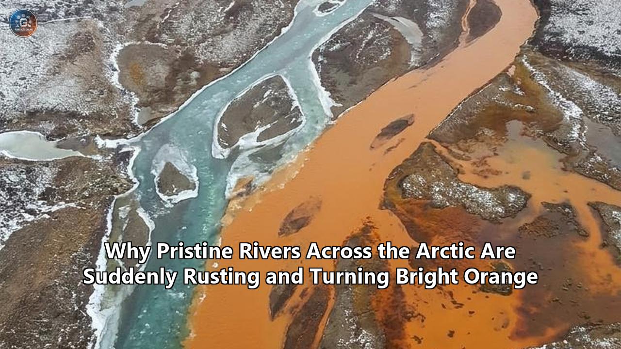
On a late-summer flight over northern Alaska’s Brooks Range, stretches of water that once looked like liquid glass now resemble rust spreading through a cracked engine block. From thousands of feet in the air, the sight is unmistakable: vibrant, opaque orange ribbons cutting through a landscape of dark green tundra and gray stone. On the ground, the transformation is even more jarring. Clear mountain tributaries, historically so pure they could be drunk without filtration, are running with the consistency and color of milky orange juice, their bottoms coated in thick, rust-colored sediment and their waters turned highly acidic.
This striking phenomenon of arctic rivers turning orange is no longer a localized mystery. A comprehensive study published in the journal Communications Earth & Environment has confirmed that this ecological crisis is expanding rapidly across the polar north, driven by the accelerating thaw of ancient permafrost. What once acted as a stable geological freezer is now actively thawing, unlocking minerals that have been sealed underground for thousands of years and releasing them into the region's most pristine watersheds.
The scale of the crisis is immense. Researchers from the National Park Service, the U.S. Geological Survey (USGS), the University of California, Davis, and the University of Alaska, Anchorage, have mapped more than 200 impacted watersheds across a region of northern Alaska roughly the size of Texas. Many of these orange-stained waters are located within some of the nation’s most remote and protected lands, including Gates of the Arctic National Park and Preserve, Kobuk Valley National Park, and the Noatak National Preserve.
The implications are profoundly troubling. The chemical makeup of these rivers is shifting dramatically, with pH levels plummeting to levels as acidic as vinegar, while concentrations of toxic heavy metals like aluminum, cadmium, nickel, and copper are skyrocketing. As these toxic plumes flow downstream, they are suffocating aquatic life, destroying critical spawning habitats for salmon, and threatening the drinking water and food security of remote Indigenous communities.
Resolving this crisis presents an unprecedented challenge. Unlike traditional industrial pollution, which can be traced to a single pipe or mine and mitigated with localized containment, the rusting of the Arctic is a diffuse, decentralized reaction occurring across thousands of square miles of roadless wilderness. Because there is no direct way to refreeze the warming tundra, scientists, Indigenous leaders, and policymakers are pivoting toward a framework of predictive forecasting, targeted ecological protection, and community adaptation to navigate this permanent alteration of the northern landscape.
Defining the Challenge: A Pristine Wilderness Under Siege
For decades, the Brooks Range was considered one of the final, untouched sanctuaries of the natural world. In his classic environmental literature, writer John McPhee described Alaska’s Salmon River as possessing "the clearest, purest water" he had ever seen. But in the summer of 2019, that legendary clarity vanished. The Salmon River turned a dull, turbid orange and has remained discolored ever since.
The visual transformation is only the surface of a much deeper ecological collapse. When a river system experiences this degree of mineralization, the entire aquatic food web is disrupted. Field researchers visiting newly rusted tributaries have documented a near-complete loss of biodiversity within months of the water changing color.
[Healthy Clearwater Stream]
       │ (pH ~ 8.0, High Dissolved Oxygen)
       ▼
[Deepening Permafrost Thaw]
       │ (Active layer melts; pyrite & wetlands exposed)
       ▼
[Acid Rock Drainage & Microbial Mobilization]
       │ (Sulfuric acid created; heavy metals dissolved)
       ▼
[The Rusting Event] ──► pH drops to ~2.3
       │            ──► Iron oxidizes into rust particles
       ▼
[Ecological Collapse]
       ├── Gill suffocation in salmon & trout
       ├── Smothering of benthic biofilm & macroinvertebrates
       └── Degradation of Indigenous drinking water sources
The first clear evidence of this biological toll emerged from a tributary of the Akillik River in Kobuk Valley National Park. In 2017, the tributary was a healthy, clear-water stream. By 2018, it had turned a milky, rusted orange. Biological surveys conducted before and after the color change revealed that the stream had completely lost two of its dominant resident fish species: the Dolly Varden trout and the slimy sculpin.
"Our data suggests that when the river turned orange, we saw a significant decrease in macroinvertebrates and biofilm on the bottom of the stream, which is essentially the base of the food web," said Brett Poulin, an assistant professor of environmental toxicology at UC Davis and a principal investigator in the ongoing research. Without the biofilm—the slimy layer of algae and microbes coating river rocks—and the aquatic insects that feed on it, the stream can no longer support fish populations.
The geographical spread of this phenomenon is accelerating. Satellite data analyzed by the International Arctic Research Center (IARC) shows that in some parts of the Brooks Range, the frequency of visibly discolored rivers nearly doubled over a ten-year period, jumping from roughly one-third of observed streams in the early 2000s to nearly three-quarters by the late 2010s. The crisis is moving from isolated headwater creeks into major river systems like the Noatak, the Wulik, and the Kobuk, which run for hundreds of miles to the Alaskan coast.
This expansion represents a direct threat to human health and survival in rural Alaska. Indigenous communities, such as the coastal village of Kivalina, rely on these rivers for both clean drinking water and subsistence fishing. Kivalina sits at the mouth of the Wulik River, where residents harvest Dolly Varden and various species of salmon to feed their families through the winter. As tributaries feeding the Wulik begin to turn orange, residents face the terrifying prospect of losing their primary food source and having their municipal water supply contaminated by heavy metals.
What Went Wrong: The Science of Permafrost Decoupling
To understand why these remote rivers are suddenly rusting, scientists have had to look beneath the surface of the tundra. The primary driver of this environmental shift is global climate change, which is warming the Arctic at a rate nearly four times faster than the global average. This intense warming is destabilizing the region's permafrost—the soil, rock, and organic matter that has remained frozen continuously for thousands of years.
As the climate warms, the "active layer" of the soil—the top layer that thaws during the summer and refreezes in the winter—is digging deeper into the earth. In addition, exceptionally warm summers are triggering the formation of "taliks," which are pockets of permanently unfrozen ground sandwiched between the active layer and the deeper permafrost.
When these deep layers thaw, they expose minerals that have been locked away from the elements since the last ice age. When water and oxygen infiltrate this newly thawed soil, they kickstart a powerful geochemical reaction known as acid rock drainage.
               [Atmospheric Warming]
                         │
                         ▼
             [Permafrost Thaw Deepens]
             /                       \
            /                         \
 [High-Elevation Slopes]       [Low-Elevation Wetlands]
        │                                 │
 [Pyrite Oxidation]              [Anaerobic Conditions]
        │                                 │
 [Creates Sulfuric Acid]         [Microbes Consume Iron]
        │                                 │
 [Leaches Metals from Rock]      [Soluble Iron Mobilized]
        \                                 /
         \                               /
          ▼                             ▼
       [Acidic, Metal-Rich Groundwater Seeps into River]
                         │
                         ▼
        [Dissolved Iron Meets Oxygenated Stream Water]
                         │
                         ▼
            [Oxidation & Rust Precipitation]
                         │
                         ▼
          [Bright Orange, Toxic Turbid River]
The key mineral behind this process is pyrite, commonly known as "fool's gold". Pyrite is an iron disulfide mineral abundant in the bedrock of the Brooks Range. For millennia, the frozen ground protected this pyrite from reacting with oxygen or water. But with the permafrost thawing, that protection has vanished.
“When pyrite meets water, it comes apart," explains Tim Lyons, a biogeochemist at the University of California, Riverside, and a co-author of the recent studies. "It breaks down into iron and sulfur, creating sulfuric acid as well as sulfate and other toxic metals."
This sulfuric acid acts as a powerful solvent. As it moves through the newly thawed soil, it dissolves other metals present in the surrounding rock, including aluminum, zinc, cadmium, nickel, and copper. When this highly acidic, metal-laden groundwater finally seeps into a surface stream, it encounters oxygen-rich water.
The oxygen causes the dissolved iron to oxidize, transforming it into microscopic, solid particles of iron oxide—essentially, rust. It is this suspended rust sediment that causes the dramatic phenomenon of arctic rivers turning orange.
This process has led to extreme water quality degradation. In some of the smaller headwater streams in the Brooks Range, researchers have recorded pH levels as low as 2.3. For context, a healthy Arctic river typically has a slightly alkaline pH of around 8.0. A pH of 2.3 is highly corrosive, matching the acidity of lemon juice or vinegar. Water this acidic immediately burns the soft tissues of aquatic organisms and dissolves the protective mucus layers on fish.
Even in larger rivers where the acidity is diluted by tributary mixing, the sheer volume of iron particles remains a major hazard. The fine rust sediment does not easily settle out of the water. It can remain suspended in the current for more than 60 miles downstream, blanketing the riverbed in a suffocating orange silt that destroys the clean gravel habitats where salmon spawn and insects live.
Unmasking the Dual Pathways: The June 2026 Breakthrough
While scientists understood the basic chemistry of pyrite weathering, the study published in Communications Earth & Environment revealed that the rusting process is far more complex than a single chemical reaction. The research team, led by scientists from the University of Alaska Fairbanks and UC Riverside, demonstrated that the warming tundra is rusting the rivers through two entirely distinct environmental pathways, depending on the local topography and soil conditions.
Pathway 1: High-Elevation Acid Rock Drainage
This is the classic chemical weathering process described above, occurring primarily on steep, rocky mountain slopes and alpine watersheds. On these high-altitude slopes, the thawing of permafrost exposes sulfide-rich bedrock directly to the atmosphere and seasonal meltwater. Because these environments are highly oxygenated, the oxidation of pyrite occurs rapidly and purely chemically, generating vast quantities of sulfuric acid and leaching heavy metals. This pathway produces the most highly acidic streams, with low pH values and high concentrations of toxic elements like cadmium and aluminum.
Pathway 2: Low-Elevation Wetland Biogeochemistry
In the lower-elevation valleys and flatter tundra landscapes, the mechanism is entirely different, driven by biology rather than pure chemistry. Here, the thawing of ice-rich permafrost causes the ground to collapse and sink, creating waterlogged, oxygen-poor wetlands known as thermokarst terrain.
Because these wet soils contain very little oxygen, the chemical oxidation of iron cannot occur. Instead, specialized anaerobic microbes (mostly bacteria) thrive in the soggy, low-oxygen depths. To survive, these microbes perform "iron respiration"—breathing in oxidized iron from the soil instead of oxygen. This microbial activity converts insoluble iron into a highly soluble, dissolved form.
As groundwater slowly moves through these wetlands, it carries this dissolved, invisible iron toward local streams. The moment this iron-rich groundwater emerges into a flowing, oxygen-rich river, it undergoes a sudden chemical transition. The dissolved iron reacts instantly with the oxygen in the river water, precipitating out of solution as solid rust particles.
               [Permafrost Thaw in Wetlands]
                             │
                             ▼
              [Soggy, Low-Oxygen Thermokarst]
                             │
                             ▼
             [Microbes Breathe Oxidized Iron]
                             │
                             ▼
               [Soluble Iron Accumulates in
                 Subsurface Groundwater]
                             │
                             ▼
              [Groundwater Seeps into River]
                             │
                             ▼
                [Soluble Iron Meets Oxygen]
                             │
                             ▼
            [Chemical Precipitation of Rust]
                             │
                             ▼
             [Riverbed Coated in Orange Silt]
This second pathway explains why many rivers in flatter, wetland-dominated valleys are turning bright orange without experiencing the extreme, battery-acid drops in pH seen in mountain streams. The water remains relatively neutral in pH, but it becomes choked with suffocating rust particles that destroy the benthic habitat.
The Geochemical Lag Effect
The study also revealed a crucial temporal element to the rusting phenomenon: a delayed geochemical "lag effect."
During the peak of summer, the active layer of the tundra thaws to its deepest point, releasing dissolved metals and iron into the subsurface groundwater. However, because groundwater moves very slowly through the flat Arctic terrain, these mobilized metals do not always reach the rivers immediately.
As winter approaches, the surface soil refreezes from the top down, trapping these metal-rich waters in the subsurface. It is only during the subsequent spring melt and summer thaw that these trapped, highly concentrated mineral reserves are flushed out of the ground and into the river networks.
This lag effect explains why a river may run clear during a historically warm summer, only to suddenly turn a deep, milky orange the following year, even if that subsequent year is relatively cool. This discovery has provided scientists with a vital tool for predicting where and when the next river systems are likely to fail.
Ecological and Sociological Impacts: The Cost of a Rusted Arctic
The environmental consequences of this geochemical shift are far-reaching, threatening both the natural biodiversity of the Arctic and the ancient, land-based traditions of the people who live there.
Threat to Aquatic Life and Fisheries
The physical and chemical changes to the water are devastating to fish, particularly cold-water salmonids like Dolly Varden, Arctic grayling, and various salmon species.
              [Dissolved Metals & High Acidity]
                             │
            ┌────────────────┴────────────────┐
            ▼                                 ▼
   [Chemical Toxicity]              [Physical Suffocation]
     * Acid burns gills               * Fine rust clogs gill membranes
     * Cellular damage from           * Spawning gravels cemented with silt
       aluminum & cadmium             * Macroinvertebrate food sources lost
            │                                 │
            └────────────────┬────────────────┘
                             ▼
               [Spawning Failure & Die-Offs]
Iron particles suspended in the water column act as a physical pollutant. As fish pump water over their gills to extract oxygen, these fine, sticky rust particles cling to the delicate gill membranes. This clogs the gills, physically suffocating the fish and preventing them from breathing.
For species like the chum salmon, which are already struggling with warming ocean temperatures, the rusting of their spawning grounds represents a potential tipping point. Salmon require clean, aerated gravel riverbeds to lay their eggs. The oxygen-rich water flowing through the gravel keeps the developing eggs alive.
When a river turns orange, the fine iron oxide sediment settles into these gravel beds, cementing the stones together and filling the gaps between them. This cuts off the flow of oxygen to the salmon nests, essentially smothering the eggs before they can hatch.
Furthermore, the high concentrations of aluminum and cadmium present in the acidic streams are directly toxic to juvenile fish. Aluminum, in particular, becomes highly soluble in acidic water and causes cellular damage to fish gills, leading to osmoregulatory failure and death. In some sampled locations, aluminum concentrations have reached nearly five times the safe limit established by the U.S. Environmental Protection Agency (EPA) for aquatic life.
Societal and Cultural Impact on Indigenous Communities
For the Iñupiat and other Indigenous peoples of northern Alaska, the health of the rivers is directly tied to their survival and cultural identity.
"These rivers are our grocery store, our highway, and our heritage," explains a tribal coordinator from the Northwest Arctic Borough. "When the water turns orange, we aren't just losing a beautiful view; we are losing our food security and our connection to the land."
                       [Permafrost Thaw]
                               │
                               ▼
               [Arctic Rivers Turning Orange]
                               │
            ┌──────────────────┴──────────────────┐
            ▼                                     ▼
   [Food Security Crisis]               [Water Resource Threat]
     * Collapse of salmon runs            * Corrosion of municipal intake pipes
     * Decline in Dolly Varden            * Toxic metals exceed EPA safety limits
     * Loss of winter food storage        * High costs for treatment systems
            │                                     │
            └──────────────────┬──────────────────┘
                               ▼
              [Threat to Indigenous Way of Life]
Subsistence harvesting is not a recreational activity in these remote regions; it is an economic necessity. In roadless communities, where store-bought food must be flown in at exorbitant costs, wild fish provide a vital source of protein and nutrition. The collapse of salmon and whitefish runs due to river rusting forces families to rely on expensive, processed foods, driving up rates of food insecurity and poverty.
The contamination also poses a threat to clean drinking water. Many remote villages do not have advanced water treatment plants capable of removing dissolved heavy metals. Standard filtration systems are designed to remove sediment and bacteria, but they cannot easily filter out dissolved aluminum, cadmium, or nickel.
The elevated acidity also increases the corrosiveness of the water. If this acidic water is drawn into local municipal water systems, it can corrode copper and lead pipes, leaching these toxic elements into the drinking water of homes and schools.
Solutions: Mapping, Forecasting, and Adaptation
The unique nature of the "rusting river" phenomenon means that traditional environmental remediation is virtually impossible. When a mining company causes acid mine drainage, the government can fine the operator, construct active treatment facilities, and use limestone barriers to neutralize the acid.
But in the vast, roadless expanses of the Brooks Range, there is no single source to contain. The acid and metals are leaking from thousands of square miles of thawing soil, across remote national parks and rugged mountain terrain.
Because we cannot stop the global warming that is thawing the permafrost, and we cannot physically plug the leaking tundra, scientists, Indigenous leaders, and policymakers are focusing on a multi-pronged approach of prediction, monitoring, and regional adaptation.
                     [Avenues for Action]
                               │
       ┌───────────────────────┼───────────────────────┐
       ▼                       ▼                       ▼
 [Early Warning Systems]  [Community Monitoring]  [Water Infrastructure]
   * Use of GIPL2 model     * Local water testing   * Upgrading filtration
   * Tracking "lag effect"  * Identifying clean       in rural villages
   * Mapping safe havens      refuges for fish      * Corrosion prevention
1. Developing Early Warning Systems Using the Lag Effect
The discovery of the delayed geochemical lag effect has opened up a major avenue for proactive management. By combining ground temperature data from the Geophysical Institute Permafrost Laboratory’s GIPL2 model with real-time stream chemistry monitoring, scientists are building predictive models.
These models allow researchers to identify which watersheds are likely to turn orange in the coming year based on the depth of the previous summer's active layer thaw.
"There's no fixing this once it starts," says Tim Lyons. "But we can give people downstream a heads up and work hard to protect the places that are still safe and less vulnerable to the rusting."
This foresight allows conservationists and fisheries managers to identify "refugia"—watersheds with stable, cold permafrost that are unlikely to rust. By focusing conservation efforts and habitat protections on these resilient streams, managers can ensure that salmon and Dolly Varden have safe havens to reproduce and feed.
2. High-Tech Satellite and InSAR Monitoring
Because the Brooks Range is so difficult and expensive to access by helicopter, researchers are utilizing advanced satellite remote sensing to track the spread of the rusting rivers.
Using Interferometric Synthetic Aperture Radar (InSAR) data from satellites like ALOS-2 and Sentinel-1, scientists can detect millimeter-scale ground subsidence. When ice-rich permafrost thaws, the ground sinks, indicating where minerals are likely being mobilized beneath the surface.
[Satellite Data: InSAR] ──► Detects ground subsidence (thawing permafrost)
         │
         ▼
[Water Quality Sampling] ──► Confirms high acidity & iron levels
         │
         ▼
[Predictive Map Generation] ──► Highlights vulnerable downstream fisheries
         │
         ▼
[Targeted Local Protection] ──► Protects resilient "cold-water refugia"
By layering this subsidence data over high-resolution satellite imagery that captures the visual change of arctic rivers turning orange, researchers can map the progression of the rusting front in real-time. This digital surveillance network helps identify newly impaired streams before field crews can even visit them.
3. Community-Based Science and Tribal Water Security
To bridge the gap between scientific modeling and the immediate needs of remote communities, federal agencies are partnering with Alaska Native tribes to establish community-based monitoring programs.
Under these initiatives, local residents are trained and equipped to conduct regular water sampling in their local rivers. This provides scientists with a steady stream of field data while empowering local communities with real-time information about the safety of their drinking water and the health of their subsistence fisheries.
Additionally, the state of Alaska and federal partners are exploring funding mechanisms to upgrade municipal water treatment systems in rural villages. These upgrades focus on installing specialized ion-exchange and advanced filtration technologies capable of removing dissolved heavy metals and neutralizing acidic water before it enters domestic distribution lines.
4. Global Policy Leverage
Finally, the stark visual of arctic rivers turning orange is being used as a powerful communication tool in international climate policy negotiations. While the release of greenhouse gases like carbon dioxide and methane from thawing permafrost is invisible, the rusting of the Arctic’s rivers is a vivid, tangible manifestation of climate change that can be seen from space.
Climate advocates and scientists are presenting these findings at global forums to illustrate that the impacts of warming are not slow, distant threats, but immediate, cascading disasters that are permanently altering the physical and chemical baseline of our planet's freshwater ecosystems.
What to Watch Next: The Global Horizon
The rapid rusting of northern Alaska’s rivers is a warning sign of a planet in transition. As we look toward the future, several critical questions and upcoming milestones will shape how we understand and respond to this emerging global crisis.
Is the Rusting Spreading Globally?
While the most dramatic and thoroughly documented cases of river rusting are currently centered in Alaska’s Brooks Range, the underlying geological and climatic conditions are widespread across the global north.
"It’s already happening in Russia, and will keep happening anywhere you have the right geology and warming temperatures," warns Tim Lyons. "It started as a canary in a coal mine in the Brooks Range, but now those canaries are chirping all over."
                             [The Arctic Rusting Front]
                                         │
       ┌─────────────────────────────────┼─────────────────────────────────┐
       ▼                                 ▼                                 ▼
[The Brooks Range]               [Northern Canada]                 [Siberian Tundra]
  * Active weathering              * Geological surveying            * High organic carbon
  * Detailed mapping                 identifying sulfide               thermokarst wetlands
  * Community monitoring             and wetland risks                 beginning to discolor
Geologists are currently scanning maps of northern Canada, Greenland, and Siberia to identify areas with high concentrations of pyrite and sulfide-rich rocks situated within zones of rapidly degrading permafrost. Early reports from the Canadian Yukon and parts of northern Scandinavia suggest that similar, albeit smaller, rusting events are beginning to appear, prompting calls for an international, circumpolar monitoring network.
The Lifespan of the Rusting: How Long Will It Last?
One of the most pressing questions facing researchers is the duration of this phenomenon. Does a thawing watershed release a massive, short-term burst of acidity and iron that eventually runs dry, allowing the river system to recover? Or are we looking at a sustained chemical output that will last for decades, or even centuries, until the permafrost is completely gone?
Currently, sediment cores taken from Alaskan lakes and ancient floodplain deposits show that similar, highly localized rusting events occurred naturally during past warm epochs, such as the Holocene Thermal Maximum thousands of years ago. However, those historical events were regional and temporary.
The scale of today’s human-caused warming is unprecedented, and scientists do not yet know if these ecosystems can ever return to their baseline clear-water states. Continuous monitoring of the oldest "orange" rivers, such as those that first turned color in 2008, will provide key clues about the long-term trajectory of these chemical shifts.
Upcoming Milestones in Arctic Research
Over the next few years, several key research initiatives will deliver crucial data on the progression of this crisis:
- Integrated Hydrological Modeling: Teams from the USGS and the National Park Service are working to integrate hydrological flow models with permafrost degradation models. This will allow scientists to map not just where the soil is melting, but exactly how much toxic runoff will reach major salmon-producing rivers each summer.
- Toxicity Threshold Studies: Toxicologists are conducting laboratory experiments to establish the precise thresholds of dissolved iron and aluminum that various salmon species can tolerate at different stages of their life cycles. This data will help tribal councils and state managers identify which rivers require immediate habitat interventions or emergency stocking programs.
- The 2026/2027 Field Campaigns: Remote field crews are deploying advanced, autonomous water-quality sensors across the Brooks Range. These sensors will record pH, temperature, conductivity, and turbidity in real-time throughout the winter and spring, providing the first continuous, year-round dataset on how ice cover affects the concentration and transport of these toxic metals.
The sight of crystal-clear rivers turning into bright, acidic streams of orange rust is a stark reminder that the impacts of a warming planet are not always gradual or predictable. They can occur in sudden, irreversible shifts that rewrite the chemistry of entire landscapes.
While we cannot immediately stop the thaw of the northern wilderness, our ability to map, forecast, and adapt to these changes will determine the survival of the vital fisheries, ancient cultures, and spectacular ecosystems of the global Arctic.
Reference:
- https://timesofindia.indiatimes.com/world/rest-of-world/alaskas-rivers-are-turning-rust-orange-and-scientists-say-the-cause-has-been-frozen-for-thousands-of-years/articleshow/131634994.cms
- https://news.mongabay.com/2025/09/alaskan-rivers-turn-orange-as-permafrost-thaws-threatening-fish-and-communities/
- https://www.ucdavis.edu/climate/news/alaskas-rusting-waters-pristine-rivers-and-streams-turning-orange
- https://www.arctictoday.com/why-arctic-rivers-are-turning-orange/
- https://www.discoverwildlife.com/environment/thawing-permafrost-turning-rivers-orange-alaska
- https://cnas.ucr.edu/media/2026/06/03/arctic-rivers-are-bleeding-orange-scientists-just-found-toxic-origin
- https://www.nationalparkstraveler.org/2026/06/scientists-confirm-melting-permafrost-colors-alaskan-rivers-orange
- https://www.space.com/alaska-rivers-turning-bright-orange-and-acidic-toxic-metal-escapse-permafrost
- https://www.popsci.com/environment/orange-rivers-alaska/
- https://www.eurekalert.org/news-releases/1097578
- https://arcticportal.org/ap-library/news/3790-rivers-are-turning-orange-in-alaska-as-permafrost-thaws
- https://www.theguardian.com/us-news/article/2024/may/22/alaska-rivers-turning-orange
- https://www.popsci.com/environment/orange-rivers-alaska/
- https://www.nps.gov/articles/000/new-research-shows-why-arctic-streams-are-turning-orange.htm
- https://uaf-iarc.org/2026/04/thawing-permafrost-and-rusting-rivers-update/
- https://www.earth.com/news/arctic-rivers-are-turning-orange-will-they-ever-clear-up/
- https://www.usgs.gov/centers/alaska-science-center/news/why-are-arctic-rivers-turning-orange