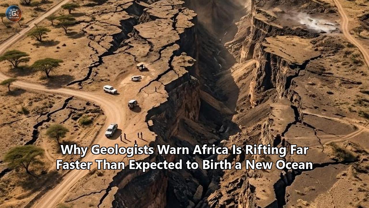
A silent mechanical collapse deep beneath the East African savannah has pushed the continent past a point of no return. In a seismic and structural investigation published in Nature Communications, geophysicists have determined that the continental lithosphere beneath the Turkana Rift in northern Kenya and southern Ethiopia has thinned to a critical threshold of just 13 kilometers. This rapid structural decay signals that the East African Rift System has entered the irreversible "necking" phase—the final mechanical stage of continental extension before the crust shears completely through and gives way to a marine basin.
The finding shatters longstanding geodynamic models that treated the breakup of Africa as a purely quiescent, multi-tens-of-millions-of-years crawl. By demonstrating that the central axis of the rift has already surrendered more than 60 percent of its original crustal thickness, researchers have confirmed that the geodynamic sequence of Africa rifting new ocean basins is advancing at a pace far faster than previously calculated.
"We found that rifting in this zone is more advanced, and the crust is thinner, than anyone had recognized," said Christian Rowan, a geoscientist at Columbia University’s Lamont-Doherty Earth Observatory and lead author of the study. "Eastern Africa has progressed further in the rifting process than previously thought. The thinner the crust gets, the weaker it becomes, which helps promote continued rifting".
This accelerated thinning changes how earth scientists understand continental disintegration. Rather than enduring a uniform, sluggish stretching over 30 to 50 million years, the lithosphere along the Gregory Rift branch appears to be yielding rapidly under the combined assault of upward buoyant forces, extreme thermal erosion from deep mantle plumes, and magma wedging. The continent is actively unraveling along a 6,000-kilometer scar stretching from the Red Sea to Mozambique. Within a geologically brief window—potentially just a few million years—the low-lying depressions will breach, seawater will rush in from the Red Sea and the Gulf of Aden, and the Horn of Africa will drift away as an isolated island continent.
                 AFAR TRIPLE JUNCTION
             (Red Sea - Gulf of Aden - EARS)
                        /       \
                       /         \
         Nubian Plate /           \ Arabian Plate
                     /             \
                    |   TURKANA     |
                    |    RIFT       |
                    | (13km crust)  |
                    |   "Necking"   |
                    |    Phase      |
                    \               /
                     \             /
                      \           /
                       \         / Somali Plate
                        \       / (Horn of Africa)
                         |     |
                         |  E  |
                         |  A  |  <--- Accelerated rifting
                         |  R  |       driven by African Superplume
                         |  S  |       and magma intrusion
                         |     |
The Physics of Necking: When Tectonic Plates Stop Stretching and Snap
To understand why geologists are issuing urgent reassessments, one must understand how continents die. Continental crust averages between 35 and 40 kilometers in thickness—a buoyant, rigid slab of granitic and metamorphic rock floating above the denser peridotite of the upper mantle. When tectonic stresses pull a landmass apart, the crust initially accommodates the strain through wide-scale, diffuse faulting. Large fault blocks drop down to form grabens, producing the majestic, cliff-sided valleys seen across Kenya, Tanzania, and Ethiopia.
Eventually, the stretching reaches a mechanical tipping point known as lithospheric necking. Like a strip of warm metal or taffy pulled from both ends, the middle suddenly narrows and focuses all subsequent deformation into a tightly confined axial zone.
Using deep seismic reflection profiling, gravity modeling, and acoustic wave transit times, Rowan’s team mapped the subsurface architecture beneath the Turkana depression. What they discovered beneath the basalt-capped surface was an abrupt, localized crustal trough. Outside the rift shoulders, the African crust retains its stable thickness of over 35 kilometers. But beneath the center of the Turkana basin, the crust has collapsed to roughly 13 kilometers.
"Once crustal thickness drops below 15 kilometers, the mechanical behavior of the lithosphere fundamentally changes," explained study co-author Folarin Kolawole, a structural geologist at Columbia University. "At that stage, the brittle upper crust and the ductile lower crust can no longer support regional tectonic loads. Strain localizes intensely along the rift axis. The system crosses a threshold where necking self-propagates, accelerating fault slip and crustal attenuation".
This localized collapse means the Turkana Rift is no longer in an early, exploratory phase of stretching. It is the only directly observable continental rift on Earth currently caught in the critical act of necking—the penultimate step before continental rupture and the upwelling of pure basaltic ocean floor.
The implication is profound: the eastern arm of the African continent has already completed the most mechanically difficult portion of the breakup process. The crust is structurally compromised, primed for rupture, and running on an expedited geological schedule.
Magma Wedges and the African Superplume
Tectonic plate motions are driven by forces operating on scales of millimeters per year. Along the East African Rift System (EARS), geodetic GPS sensors demonstrate that the massive Nubian Plate to the west and the smaller Somali Plate to the east are drifting apart at rates between 2 and 7 millimeters annually, depending on the latitude. By standard tectonic friction models, pulling a 35-kilometer-thick continental plate apart at a rate of 5 millimeters per year should require tens of gigapascals of tensile stress—forces far greater than those generated by boundary plate motions alone.
Why, then, is the African continent ripping open so much faster than classical mechanics predicts? The answer lies thousands of kilometers below the surface, inside the Earth’s mantle.
Cross-Section: Magma-Assisted Lithospheric Rupture

Surface        Normal Faults       Axial Rift Valley        Active Volcanoes
~~~~~~~~~~~~~~\                  /=====================\                  /~~~~~~~~~~~~~~
               \                /                       \                /
Crust (35km)    \  Crust       /   CRUST THINNED TO     \       Crust   /   Crust (35km)
                 \ Thinned    /         13 KM            \     Thinned /
------------------\          /                            \           /------------------
                   \        /      ^        ^        ^     \         /
Lithospheric Mantle \      /       |  Dike  |  Dike  |      \       / Lithospheric Mantle
                     \    /        |  Inj.  |  Inj.  |       \     /
======================\  /=========|========|========|========\   /======================
Asthenosphere          \/          | Magma  | Magma  |         \ /
                                   | Conduit| Conduit|
                                   \________/________/
                                           |
                                 [ Upwelling Mantle Plume ]
                                (African Superplume / LLSVP)
Beneath southern and eastern Africa sits one of the planet’s two massive thermochemical anomalies: the African Large Low-Shear-Velocity Province (LLSVP), often called the African Superplume. This colossal column of superheated, buoyant rock rises from the core-mantle boundary 2,900 kilometers down, branching out into discrete, mushroom-shaped upwellings beneath the Ethiopian Dome and the Kenya Dome.
The superplume influences the rift through two distinct, compounding mechanisms:
- Dynamic Uplift and Topographic Gravitational Potential: The hot, buoyant mantle elevates the East African plateau more than a kilometer above sea level. This high topography exerts immense horizontal gravitational stress, effectively forcing the elevated crust to slide apart under its own weight.
- Magma-Assisted Rifting: As mantle material decompresses beneath the thinning crust, it partially melts, generating colossal reservoirs of basaltic magma.
This second mechanism changes the physics of plate tectonics. When magma rises into the lower and middle crust, it fills vertical cracks, forming tabular sheets called dikes. Magma injected at high hydraulic pressure pushes the walls of the crust apart from the inside out.
Geophysicists have calculated that magma wedging reduces the tectonic tensile force required to break a continental plate by up to 85 percent. Rather than tectonic forces having to mechanically pull brittle granite apart until it snaps, magma acts as an industrial wedge, prying the rock along weak zones and replacing the solid continent with molten basalt.
"Magma-assisted rifting explains why the process moves so aggressively despite relatively low far-field tectonic speeds," said Sarah Stamps, a geophysicist at Virginia Tech who specializes in East African kinematic modeling. "The plate is not just being pulled apart by distant subduction zones; it is being thermally eroded from below and hydraulically fractured by ascending melt".
The speed of this phenomenon was put on display in September 2005 in the Afar Depression of northern Ethiopia. Near the Dabbahu volcano, a series of moderate earthquakes signaled a sudden subsurface movement. Within just 10 days, a subterranean dike opened along a 60-kilometer stretch of the desert. Approximately 2.5 cubic kilometers of magma forced its way between the plates, pushing the crust apart by up to 8 meters in a matter of hours.
To achieve 8 meters of separation through steady tectonic drift alone would have required nearly 400 years. In Afar, magma accomplished it in less than a fortnight. The lesson was clear: rifting does not advance along a smooth linear curve. It occurs in violent, nonlinear pulses that can advance a continent’s demise by centuries in a single magmatic event.
Afar: Observing Seafloor Spreading on Dry Land
While the Turkana Rift provides the clearest snapshot of crustal necking, the Afar Depression represents the terminal stage of the continental lifecycle. Located at the convergence of Ethiopia, Eritrea, and Djibouti, Afar is one of only two places on the globe—the other being Iceland—where an active mid-ocean spreading ridge is exposed above sea level.
Here sits the Afar Triple Junction, where three tectonic plates diverge at roughly 120-degree angles: the Arabian Plate, heading north-northeast; the Nubian Plate, drifting west; and the Somali Plate, tracking southeast. The Arabian Plate moves away at an astonishing 20 to 25 millimeters per year, while the African subplates move apart at 5 to 7 millimeters annually.
                 RED SEA RIFT
               (Arabian - Nubian)
                       ^
                       |
                       |
               DANAKIL DEPRESSION
             (-125m below sea level)
                       |
GULF OF ADEN <---------*---------> SOMALI PLATE
  SPREADING            |          (Moving SE at ~5mm/yr)
    RIDGE              |
                       v
             MAIN ETHIOPIAN RIFT
                 (EARS Axis)
Recent re-evaluations of high-resolution aeromagnetic surveys have clarified the nature of the crust beneath the Afar desert. A research team led by Emeritus Professor Peter Styles of Keele University digitized and synthesized vintage magnetic data originally gathered in the late 1960s, comparing it against modern satellite magnetometer observations.
When oceanic crust forms at mid-ocean ridges, cooling basalt records the prevailing orientation of Earth's magnetic field, creating a distinctive pattern of parallel, alternating "magnetic stripes" on either side of the spreading center. Continental crust does not display this signature.
Styles and his colleagues verified that the crust beneath parts of the Afar Depression no longer possesses continental properties. The magnetic data shows linear zebra-stripe anomalies running through the volcanic bedrock of the desert floor. Structurally, chemically, and magnetically, the floor of the Afar Depression is already oceanic crust.
The only thing separating the Danakil Depression from the Red Sea is a narrow 20-kilometer coastal ridge of volcanic hills known as the Danakil Horst. The floor of the Danakil depression sits more than 120 meters below global sea level. It is one of the lowest, hottest, and most inhospitable dry places on the surface of the Earth.
If an earthquake, a large-scale dike intrusion, or volcanic deflation breaches this topographic barrier, water from the Red Sea will cascade down into the basin. What is now salt flats, sulfur chimneys, and the boiling lava lake of Erta Ale would instantly become an active marine gulf. While continental breakup was once projected to require dozens of millions of years of quiescent stretching, the mechanics governing Africa rifting new ocean geography indicate that active magma injection can fast-track the transition with startling efficiency.
The Turkana Sedimentation Trap: Rethinking the Cradle of Humankind
The discovery that the Turkana Rift is rifting faster and entered the necking phase millions of years ago has generated an unexpected shockwave in an entirely different scientific field: paleoanthropology.
For more than half a century, the East African Rift System—and northern Kenya’s Lake Turkana in particular—has been celebrated as the "Cradle of Humankind". The region has yielded thousands of hominin fossils, including iconic specimens of Australopithecus anamensis, Paranthropus boisei, Homo habilis, and the nearly complete 1.6-million-year-old Homo erectus skeleton known as "Turkana Boy".
For decades, evolutionary biologists debated why human ancestors seemed to evolve and proliferate so specifically within this narrow corridor. Hypotheses often revolved around environmental triggers: the rising rift mountains blocked moist air from the Indian Ocean, transforming dense rainforests into open savannahs and forcing tree-dwelling apes to adopt bipedalism to travel across grasslands.
Rowan and Kolawole’s geophysical findings introduce a more mechanical explanation: northern Kenya might not have possessed a unique population density of early hominins; rather, it was uniquely suited to preserve them.
Sedimentation Mechanics in an Active Necking Zone

Pre-Necking (~5 Ma): Slow subsidence, low sediment burial rate
Surface ----------------------------------------------------
Crust (30 km) -> Fossils exposed to scavengers and weathering -> Low preservation

Necking Phase (4 Ma - Present): Rapid axial collapse and deep sediment trap
                                   [Proto-Omo River]
                                         |   |
                                         v   v
Fault Scarp                          Lake Turkana                         Fault Scarp
  |  \      Fine Sediments & Volcanic Ash Rapidly Inundate Graben         /  |
  |   \==================================================================/   |
  |    \    [ RAPID BURIAL OF HOMININ SPECIMENS (Turkana Boy, etc.) ]   /    |
  |     \--------------------------------------------------------------/     |
  v      \                  CRUST COLLAPSED TO 13 KM                  /      v
          \__________________________________________________________/
The study calculated that the Turkana Rift initiated its necking phase roughly 4 million years ago, immediately following an epoch of regional volcanic eruptions. When the crust abruptly thinned to 13 kilometers, the rift floor underwent accelerated tectonic subsidence. The land dropped, creating a deep geographic catch-basin directly in the path of the ancestral Omo River and massive sediment discharge networks.
This sudden downward flexure triggered a massive accumulation of fine-grained lake and river sediments, interspersed with protective layers of volcanic tuff.
- Accelerated Subsidence: As necking localized strain along the axis, the valley floor sank rapidly, continuously generating new accommodation space for sediment deposition.
- Rapid Burial: Skeletons of hominins dying near the lake shores or along river channels were buried by mud, silt, and ash within weeks or months, shielding them from scavengers, solar degradation, and mechanical weathering.
- Geochemical Preservation: The volcanic ash layers provided both the alkaline chemistry necessary to mineralize bone tissue and the isotopic markers (potassium-argon and argon-argon dating) that modern scientists use to date fossils with precision.
The very tectonic mechanisms that are splitting Africa apart served as the planet's most efficient fossilization machine. Early hominins may have inhabited vast swaths of Central, West, and Southern Africa in equal numbers, but their remains decomposed on stable cratons where geological burial was slow or nonexistent. In the Turkana Rift, the crust was actively failing beneath their feet, creating the exact depositional conditions required to preserve their bones across four million years of evolutionary time.
Infrastructure on a Splitting Plate: The Present Hazard
While the final flooding of the rift is a long-term geological inevitability, the immediate consequences of an accelerating breakup present acute challenges for the modern nations situated along the tectonic boundary.
In Kenya, Ethiopia, and Uganda, the East African Rift is not an abstract concept; it is an active hazard slicing across roads, rail networks, electrical grids, and urban centers.
In March 2018, heavy seasonal rains near the town of Mai Mahiu, along the floor of the Kenyan Rift Valley, were accompanied by sudden, deep ground fissures that cleaved the Nairobi-Narok highway in two. A chasm more than 15 meters deep and 20 meters wide opened across farm plots and infrastructure corridors, swallowing vehicles, severing fiber-optic links, and forcing dozens of families to evacuate.
While sensationalized initial reports claimed the continent had "split in half overnight," geological surveys proved the reality was more insidious: long-dormant subsurface faults had slipped due to ongoing tectonic extension, and torrential stormwater had flushed the unconsolidated volcanic ash into the widening underground voids, triggering surface collapse. The underlying cause, however, remains unchanged: the crust across Kenya is under active, relentless tensile failure.
Key Infrastructure Intersecting the Active Rift
--------------------------------------------------------------------------------------
Infrastructure Project        Location                Tectonic Vulnerability
--------------------------------------------------------------------------------------
Standard Gauge Railway (SGR)  Nairobi to Naivasha     Bridges active normal fault scarps
                              (Kenya)                 and volcanic ash grabens.

Olkaria Geothermal Field      Hell's Gate National    Exploits high-enthalpy magma at
                              Park (Kenya)            shallow depth; high seismicity risk.

LAPSSET Corridor              Kenya - S. Sudan -      Crosses the active Turkana necking
                              Ethiopia                zone with oil pipelines and roads.

Grand Ethiopian Renaissance   Blue Nile               Upstream from the active Main
Dam (GERD) / Grid Networks    (Ethiopia)              Ethiopian and Afar extensional faults.
--------------------------------------------------------------------------------------
Engineers constructing Kenya’s Standard Gauge Railway had to design specialized viaducts and flexible track beds across the Rift Valley escarpment to accommodate seismic shocks and gradual aseismic fault creep. The trans-national LAPSSET (Lamu Port-South Sudan-Ethiopia-Transport) corridor runs directly across the Turkana necking zone, where crustal stress is at its highest. Pipelines, roads, and optical lines crossing this corridor are exposed to episodic displacement from dike intrusions and fault reactivations.
Yet this tectonic unraveling also offers economic opportunity. The shallow magma chambers that weaken the crust make East Africa one of the richest geothermal provinces on Earth. At Kenya’s Olkaria geothermal complex, located inside the caldera of the Olkaria volcanic center, steam wells tap fluid reservoirs heated by magmatic intrusions just a few kilometers below the surface. Geothermal power now generates nearly 50 percent of Kenya’s electricity, providing a stable baseload renewable resource.
The nations of the East African Community are caught in a precarious trade-off: exploiting the thermal bounty of a dying continent while reinforcing their infrastructure against the inevitable slips, quakes, and eruptions that accompany Africa rifting new ocean conduits through their borders.
Anatomy of Earth’s Next Ocean: The 5-Million-Year Map
How will the final rupture play out? Geodynamic models synthesized with the new Turkana crustal data allow marine geologists to map the sequential creation of Earth’s sixth ocean.
The separation will not happen uniformly along the 6,000-kilometer rift. Instead, the birth of the ocean will arrive in cascading structural stages:
Projection: 1 to 5 Million Years Into the Future

      [ MEDITERRANEAN SEA ]
              |
         +----+----+
         |  EGYPT  |
         +----+----+
              |
       /============= \
      /    NEW RED     \
     /    SEA BASIN     \
    /   (Widened Gulf)   \
   |                      \
   |  NUBIAN CONTINENT     \       NEW SOMALI
   |  (Central Africa)      \     MICRO-CONTINENT
   |                         \    (Horn of Africa)
   |                          \          |
   |      NEW SEAWAY           \         |
   |    (Flooded Turkana        \        |
   |       and Afar)             \       v
   |         ~~~~~                |   /~~~~~~~~\
   |        ~~~~~~~               |  /          \
   \       ~~~~~~~~~              | |  SOMALIA   |
    \     ~~~~~~~~~~~             | |  ETHIOPIA  |
     \   ~~~~~~~~~~~~~            |  \  KENYA    |
      \~~~~~~~~~~~~~~~~           |   \_________/
       \   INDIAN OCEAN INLET    /
        \=======================/
                    |
              [ INDIAN OCEAN ]
Stage 1: The Danakil Inundation (100,000 to 500,000 Years)
The first permanent marine invasion will strike the Afar and Danakil depressions in the north. Because the floor of the Danakil basin is already more than 100 meters below sea level, it requires only a minimal tectonic or volcanic collapse along the Danakil Horst to allow the Red Sea to breach.
Once breached, seawater will flood hundreds of square kilometers within days, creating a long, narrow marine basin resembling the modern Red Sea. The volcanic peaks of Erta Ale, Dabbahu, and Dallol will become submarine volcanic ridges and volcanic ocean islands.
Stage 2: Turkana Rupture and the Central Seaway (1 to 3 Million Years)
With its crust already thinned to 13 kilometers, the Turkana Rift will reach total lithospheric separation long before the thicker southern sections of the rift in Tanzania and Malawi. The necking zone will experience continuous dike swarms that will freeze into oceanic basalt, marking the transition from continental stretching to genuine seafloor spreading.
The subsiding basin will drop below sea level, connecting with the advancing marine gulf from the Afar Depression in the north and drawing in water from the Indian Ocean through low-lying coastal corridors in the south. Lake Turkana will vanish, replaced by an expansive, shallow seaway bisecting Kenya and Ethiopia.
Stage 3: Complete Isolation of the Somali Plate (5 to 10 Million Years)
Geodynamic reconstructions of Africa rifting new ocean corridors suggest that catastrophic marine flooding will occur from the north long before the southern terminus reaches complete separation. Eventually, the oceanic spreading center will propagate south through the Gregory Rift, slicing through central Tanzania and connecting with the offshore fault systems of the Mozambique Channel.
When this structural unification is complete, the Somali Plate—encompassing Somalia, eastern Ethiopia, eastern Kenya, half of Tanzania, and parts of Mozambique—will be severed from the African mainland. A new ocean, spanning hundreds of kilometers in width and floored by a mid-ocean spreading ridge, will separate the African continent from a new, massive island landmass comparable in size to the Indian subcontinent or Greenland.
Landlocked nations like Uganda, Rwanda, and Burundi will gain direct ocean proximity or island status, while the ancient supercontinental cratons of West and Central Africa will be fringed by a pristine passive continental margin, much like the Atlantic coastlines of North America and West Africa today.
Observing a Breaking World in Real Time
To refine these timelines, geophysicists have turned East Africa into the most densely monitored natural tectonic laboratory on the planet.
The traditional scientific reliance on intermittent field expeditions has been superseded by persistent space-geodetic networks. Scientists use Synthetic Aperture Radar interferometry (InSAR), processed from satellite constellations including the European Space Agency’s Sentinel-1 and the joint NASA-ISRO SAR (NISAR) platform. By bouncing radar waves off the African continent on successive orbital passes, InSAR can detect vertical and horizontal surface displacements across millions of square kilometers with millimeter-level accuracy.
InSAR data has confirmed that the magma reservoirs beneath the rift’s active volcanoes—including Menengai, Longonot, Aluto, and Erta Ale—are perpetually pulsing. Magma continuously ascends into the crust, inflates magma chambers, and intrudes into lateral dike networks, pushing the surface outward.
On the ground, international collaborations such as the RiftVolc project and the National Science Foundation’s geodetic arrays have anchored hundreds of continuous Global Navigation Satellite System (cGNSS) stations and broadband seismometers directly into the bedrock. These sensors monitor the stress state of the crust across Kenya, Ethiopia, and Uganda, capturing micro-earthquake swarms that mark where the brittle crust is cracking ahead of ascending magma wedges.
Continuous satellite radar and global positioning arrays now treat the active zones of Africa rifting new ocean floor as prime real-time observatories for planetary evolution. Geologists are measuring the exact rate at which mantle plumes inject heat into the lower crust, melting the lithospheric root and stripping away the continent's structural integrity.
What the latest data from the Turkana Rift makes clear is that Earth’s tectonic clock does not operate on a smooth, immutable tick. Continental breakup is driven by feedback loops: thinning crust weakens the plate, weakening focuses deformation, localized deformation accelerates magma ascent, and magma ascent accelerates thinning.
The East African Rift has crossed into this self-reinforcing regime. The crust beneath the cradle of humanity has thinned to a fragile 13 kilometers. The continent has already fractured, its structural foundation has yielded to mantle magma, and the birth of Earth's newest ocean is no longer a distant theoretical hypothesis—it is an active geophysical reality unfolding before modern science.
Reference:
- https://en.yenisafak.com/world/africa-splitting-faster-than-expected-as-new-ocean-takes-shape-3723370
- https://www.sciencealert.com/africa-is-breaking-apart-faster-than-we-thought-forming-a-new-ocean
- https://www.sciencedaily.com/releases/2026/04/260424233204.htm
- https://www.smithsonianmag.com/smart-news/east-africa-might-break-off-from-the-continent-sooner-than-scientists-thought-and-a-new-ocean-may-fill-the-gap-180988659/
- https://www.wionews.com/trending/africa-is-splitting-and-a-lot-sooner-than-estimated-giving-way-to-a-new-ocean-1789721006087
- https://www.ndtv.com/science/study-reveals-africas-tectonic-rift-could-create-ocean-11007771
- https://www.youtube.com/watch?v=EeP1ZMQzdUg
- https://www.discoverwildlife.com/environment/turkana-rift-east-africa
- https://www.forbes.com/sites/davidbressan/2025/11/29/forgotten-data-from-50-years-ago-reveals-how-africa-is-splitting-apart/
- https://www.futura-sciences.com/en/africas-new-ocean-is-forming-faster-than-anyone-imagined-what-will-change-for-us_32770/
- https://www.facebook.com/inspiregeoera/videos/-the-afar-triangle-where-a-new-ocean-could-be-borndeep-beneath-ethiopias-afar-de/1771444800832595/
- https://www.facebook.com/WIONews/posts/africa-is-splitting-and-a-lot-sooner-than-estimated-giving-way-to-a-new-ocean/1451014290471074/
- https://ground.news/article/scientists-just-discovered-africa-is-closer-to-breaking-apart-than-we-thought
- https://www.youtube.com/watch?v=3zExNY7518g&vl=en-US