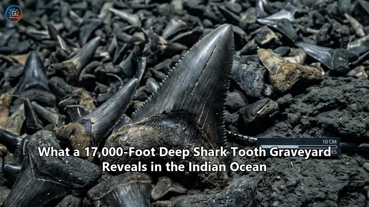
At a depth of 5,431 meters (17,818 feet) beneath the central eastern Indian Ocean, a single benthic survey trawl pulled up an extraordinary haul: hundreds of mineralized, fossilized, and modern teeth spanning more than 22 million years of marine apex predator evolution. Conducted from the Commonwealth Scientific and Industrial Research Organisation (CSIRO) research vessel RV Investigator, the deep-sea operation sampled the abyssal floor near the base of the Muirfield Seamount, southwest of the remote Cocos (Keeling) Islands.
The catalog of the expedition, published in Deep-Sea Research Part II: Topical Studies in Oceanography, confirms the retrieval of between 750 and 1,000 fossil shark teeth from a single beam trawl catch, establishing the site as an unprecedented deep-water repository. The collection contains a continuum of elasmobranch history: modern makos and great whites alongside ancestral apex macropredators, including intermediate relatives of Otodus megalodon that grew in excess of 12 meters.
================================================================================
          CHRONOLOGICAL CONTINUUM OF THE DEEP-SEA TOOTH RECOVERY
================================================================================
  Epoch / Era          Representative Species Detected       Ecological Role
--------------------------------------------------------------------------------
  Late Oligocene to    Otodus angustidens /                  Apex Macropredator
  Early Miocene        Otodus chubutensis                    (Marine Mammal Hunter)
  (~23 - 16 Ma)        (Megalodon Lineage)
--------------------------------------------------------------------------------
  Mid-to-Late Miocene  Isurus hastalis /                     Pelagic Pursuit Hunter
  (~15 - 5 Ma)         Cosmopolitodus (Broad-tooth Mako)     (Piscivore / Pinnipeds)
--------------------------------------------------------------------------------
  Pliocene to          Carcharodon carcharias /              Apex & Mesopredator
  Pleistocene          Isurus oxyrinchus / Galeocerdo        (Cetacean / Fast Pelagic)
  (~5 - 0.01 Ma)       (Modern White & Tiger Relatives)
--------------------------------------------------------------------------------
  Holocene to Modern   Modern Lamniformes & Carcharhiniformes Modern Pelagic Guild
  (Present Day)        (Shortfin Mako, Pelagic Whites)       (Apex Regulator)
================================================================================
This discovery of a concentrated shark tooth graveyard in the abyssal zone is far more than a paleontological oddity. It serves as a natural laboratory for understanding how oceanographic currents, seabed topography, and low sedimentation rates collaborate to preserve multi-million-year records of oceanic life on the open seafloor. Concurrently, the expedition mapped 22 previously uncharted seamounts and documented 1,059 species—149 of which are completely new to science, ranging from deepwater batfishes to endemic sea cucumbers.
Analyzing the mechanics of this deposit offers essential lessons regarding abyssal taphonomy, the continuous multi-epoch ecological function of seamounts, and the acute challenges facing deep-ocean conservation.
The Muirfield Seamount Deposit: Mechanics of Discovery
The sampling took place inside the Cocos (Keeling) Islands Marine Park, a vast marine sanctuary established by the Australian government that, along with the adjacent Christmas Island Marine Park, spans over 744,000 square kilometers. Using a benthic beam trawl engineered to skim epifaunal organisms and surface sediments at depths exceeding 5,000 meters, researchers had conducted 26 previous trawls targeting biological specimens across various bathymetric horizons.
On the voyage’s final benthic sample at 5.4 kilometers down, the net surfaced heavy with dense, fine sediments, manganese nodules, and calcified fragments.
                                RV INVESTIGATOR
                                  |         |
                                  | 5,431 m | Steel armored tow cable
                                  | (3.3 mi)|
                                  v         v
============================== OCEAN SURFACE ==============================
                                      |
                                      |  Water Column:
                                      |  - Pressure: ~540 atmospheres
                                      |  - Temperature: ~1.5°C
                                      |  - Zero sunlight penetration
                                      |
============================== ABYSSAL ZONE ==============================
              _.-''''-._
            .'          '.   <-- MUIRFIELD SEAMOUNT
           /   Upwelling  \      (Localized biological productivity hot-spot)
          /    Deflection  \
         /                  \
________/                    \_______[ Trawl Footprint: 5,431 m ]________
  Benthic boundary currents wash away     Depositional trough collecting:
  fine silts; heavier teeth settle down   - 750-1,000 teeth
  into topographic depressions.           - Manganese nodules
                                          - Condensation horizon of 22+ Ma
"When we put these nets down hoping to get animals, we are surveying biodiversity," said Dianne Bray, Senior Collections Officer at the Museums Victoria Research Institute, who participated in the expedition sorting operations. "So initially we thought it was just full of sediment and manganese nodules. Then we started going through it, and one of my colleagues spent at least an hour just picking shark teeth. Not all were fossils; some were relatively recent mako sharks and two species of great white shark relatives."
The recovered teeth measured between 1 centimeter (0.39 inches) for juvenile modern lamniformes up to 10 centimeters (4 inches) for fully mineralized teeth belonging to megatooth sharks within the genus Otodus.
Western Australian Museum Curator of Fishes Dr. Glenn Moore identified key anatomical markers that place the largest specimens along the critical evolutionary transition from Otodus chubutensis into Otodus megalodon:
"The teeth look to come from modern sharks, such as mako and white sharks, but also from ancient sharks including the immediate ancestor of the giant megalodon shark. This shark evolved into the megalodon, which was the largest of all sharks but died out about 3.5 million years ago. It is incredible to think we've collected all these teeth in a net from the seafloor some 4 to 5 kilometers below the ocean surface."
The physical condition of the specimens was unexpected. Despite spending millions of years exposed on the abyssal plain, the enameloid crowns of the teeth remained largely intact, retaining functional cutting serrations and pristine tip points. The organic components of the tooth roots—composed of vascularized osteodentin and collagen fibers—had long decayed, leaving voids subsequently infilled by mineral precipitations and dark manganese oxides.
Taphonomy at 5,400 Meters: How Abyssal Depressions Preserve Millennia
Sharks possess cartilaginous endoskeletons lacking the dense hydroxyapatite mineralization of teleost (bony) fish or marine tetrapods. When an elasmobranch dies, microbial decay and scavenger activity rapidly dismantle the uncalcified skeletal framework, often within weeks. The teeth, however, are shielded by enameloid—a hyper-mineralized matrix predominantly composed of fluoroapatite ($\text{Ca}_5(\text{PO}_4)_3\text{F}$), which exhibits exceptional chemical stability, low solubility, and high resistance to physical abrasion.
The fundamental physical mystery is why hundreds of teeth from different epochs, separated by millions of years, were concentrated into a single localized patch on the ocean floor. This aggregation is governed by a sequence of three distinct oceanographic and geochemical processes:
1. Ultra-Low Pelagic Sedimentation Rates
In nearshore environments, rivers and coastal runoffs deposit terrestrial sediments at rates measured in centimeters to meters per millennium. In the open abyss of the eastern Indian Ocean, thousands of miles from continental river systems, sediment deposition is dominated by pelagic "red clays" and atmospheric dust settling. Sediment accumulation here drops to less than 1 millimeter per 1,000 years.
Because burial is exceedingly slow, materials that fall to the ocean floor remain exposed on the sediment-water interface for extended epochs. Over a span of 20 million years, a sediment layer just 10 to 20 meters thick forms. A single sweep of a trawl net skimming the uppermost decimeters of sediment cuts through a highly condensed stratigraphic section, simultaneously collecting materials deposited across tens of millions of years.
2. Seamount Topography and Benthic Hydrodynamics
The site sits adjacent to the base of Muirfield Seamount. Submerged volcanic peaks disrupt deep-ocean laminar flow, generating localized turbulence, internal waves, and benthic boundary currents known as abyssal winnowing. These hydrodynamics prevent fine silts from accumulating evenly across high-relief contours.
Lighter biogenic clays are suspended and swept down-current, while denser biological remnants—such as fluoroapatite shark teeth and heavy polymetallic nodules—sink and settle into localized bathymetric hollows and structural depositional troughs. Over millions of years, the depression at 5,400 meters acted as a passive gravity trap, funnelling teeth shed in the water column above into a localized zone.
================================================================================
              GEOCHEMICAL TRANSFORMATION: ORGANIC TO MINERALIZED
================================================================================
 Stage 1: Deposition (Hours to Weeks)
 - Shark sheds tooth / carcass sinks to 5,400 m.
 - High-pressure benthic bacteria consume organic pulp and soft roots.
 - Cartilage skeleton completely disintegrates.

 Stage 2: Exposure & Winnowing (Centuries to Millennia)
 - Enameloid (fluoroapatite) resists carbonate compensation depth (CCD) dissolution.
 - Benthic boundary currents wash away surrounding silts, aggregating heavy teeth.

 Stage 3: Hydrogenous Mineral Encrustation (Millions of Years)
 - Dissolved metals in ambient bottom water precipitate onto the tooth surface.
 - Ferromanganese crusts grow at ultra-slow rates (~1-5 mm per million years).
 - The tooth becomes locked in an exposed, highly stable chemical matrix.
================================================================================
3. Fluoroapatite Preservation Below the Carbonate Compensation Depth
The trawl occurred at 5,431 meters, well below the regional Carbonate Compensation Depth (CCD), which typically sits between 4,000 and 4,500 meters in this sector of the Indian Ocean. Below the CCD, seawater is undersaturated with respect to calcium carbonate ($\text{CaCO}_3$). Calcareous shells, foraminifera tests, and coral skeletons dissolve rapidly before they can fossilize.
Fluoroapatite operates under different chemical kinetics. The presence of fluoride ions within the crystal lattice gives the mineral a far lower solubility product than calcite or aragonite, allowing the teeth to survive unaltered in acidic, high-pressure abyssal waters that dissolve standard calcium carbonate skeletons.
Paleobiological Reconstruction: 22 Million Years of Apex Predation
The sheer diversity recovered within this single shark tooth graveyard provides a direct window into the changing composition of pelagic food chains across the Cenozoic era. Elasmobranch teeth are functionally optimized tools adapted to specific prey items; shifts in crown geometry, width, serration morphology, and lateral cusplet structure trace structural shifts in marine ecosystems over geological time.
================================================================================
           EVOLUTIONARY TRAJECTORY OF APEX PREDATOR DENTAL MORPHOLOGY
================================================================================
 Lineage: Otodontidae (Megatooth Lineage)
 -------------------------------------------------------------------------------
 Species: Otodus angustidens -> Otodus chubutensis -> Otodus megalodon
 Period:  Late Oligocene      -> Early-Mid Miocene   -> Late Miocene to Pliocene
 Shape:   Narrow crown,          Broad triangular crown, Massive robust crown,
          large side cusplets    reduced side cusplets   no lateral cusplets,
                                                         hyper-dense serrations
 Prey:    Primitive Cetaceans,   Pelagic Whales, Sirenia, Large Mysticete Whales,
          Pinnipeds              Large Teleosts          Pinnipeds

 Lineage: Lamnidae (White & Mako Lineage)
 -------------------------------------------------------------------------------
 Species: Cosmopolitodus hastalis             -> Carcharodon carcharias
 Period:  Middle Miocene to Pliocene          -> Early Pliocene to Present
 Shape:   Broad, flat blade, smooth edges     -> Broad, triangular blade, coarse serrations
 Prey:    Fast-swimming teleosts, small seals -> Marine mammals, pelagic fish
================================================================================
The recovery of teeth exhibiting the morphological signature of Otodus chubutensis—characterized by broad, serrated principal crowns accompanied by reduced, distinct lateral cusplets at the base—bridges the evolutionary gap between older, smaller forms and the apex O. megalodon. This transition, occurring roughly 20 to 16 million years ago during the Miocene epoch, directly tracks the rapid diversification of cetacean (whale and dolphin) lineages.
As marine mammals grew larger and developed thicker blubber layers, the selective pressure on pelagic sharks favored broader blades capable of gouging large bites out of thick tissue rather than merely grasping slippery fish.
The simultaneous presence of smooth-edged ancestral mako teeth (Cosmopolitodus hastalis or Isurus desori) alongside modern serrated white shark teeth illustrates the historical coexistence of specialized pursuit predators and high-inertia ambush predators in the waters surrounding Muirfield Seamount. The continuous accumulation of these varied dental forms shows that the open waters above these isolated seamounts have supported complex multi-tiered apex predator guilds without interruption for tens of millions of years.
Principle 1: Abyssal Depressions as Time-Condensation Horizons
The primary scientific lesson extracted from the Muirfield Seamount site centers on the nature of deep-sea stratigraphy: the abyssal plain operates as a time-condensation horizon. In continental or shallow marine geology, the Law of Superposition dictates that successive strata isolate chronological periods into vertical columns. Deep abyssal plains present a radical deviation from this model.
TERRESTRIAL/SHELF ACCUMULATION               ABYSSAL TIME-CONDENSATION
  (High Sedimentation: 1-100 cm/kyr)            (Ultra-Low Sedimentation: <0.1 cm/kyr)

  ===================================           ===================================
  [ LAYER D: Recent Epoch          ]           [ CONDENSED STRATIGRAPHIC PLANE   ]
  -----------------------------------           [ Modern Makos (0 Ma)             ]
  [ LAYER C: Pleistocene Epoch     ]    VS.     [ Megalodon Ancestors (16 Ma)     ]
  -----------------------------------           [ Early Cenozoic Taxa (22+ Ma)    ]
  [ LAYER B: Pliocene Epoch        ]           [ (All resting on single surface) ]
  -----------------------------------           ===================================
  [ LAYER A: Miocene Epoch         ]            ^^^^^^^^ Basaltic Basement ^^^^^^^^
  ===================================
When pelagic sedimentation approaches zero, deep-sea surfaces transform into cumulative contact zones. Millions of years of biological output settle onto a single physical horizon.
This dynamic redefines how paleobiologists sample and model ancient oceanic ecosystems. On land, locating successive stages of an evolutionary lineage requires excavating through stratified rock formations across hundreds of meters of vertical depth. In the deep ocean abyss, however, a single horizontal transect can collect an integrated inventory of an entire marine lineage's evolutionary history.
This condensation phenomenon also introduces significant challenges for paleo-ecological modeling. Because specimens from distinct epochs occupy the exact same physical bedding plane, conventional spatial mapping cannot infer temporal coexistence. Researchers must rely on high-precision geochemical forensics—such as strontium isotope stratigraphy ($^{87}\text{Sr}/^{86}\text{Sr}$) and micro-computed tomography ($\mu\text{CT}$) of structural apatite—to date each tooth individually.
Without micro-geochemical dating, a sample containing both modern Isurus oxyrinchus and extinct Otodus teeth risks being misinterpreted as an anomalous prehistoric ecosystem rather than what it is: an ultra-condensed accumulation formed across millions of years.
Principle 2: Seamounts as Multi-Epoch Ecological Epicenters
The second major principle illustrated by the discovery is the long-term ecological continuity of undersea mountains. The data confirm that the waters overlying Muirfield Seamount have operated as a persistent biological gathering point spanning the late Oligocene, through the Neogene and Quaternary periods, right up to the present day.
================================================================================
               SEAMOUNT HYDRODYNAMICS AND NUTRIENT AGGREGATION
================================================================================

                             SURFACE SUNLIGHT ZONE
                             ~~~~~~~~~~~~~~~~~~~~~
      Pelagic Predators: Makos, Great Whites, Extinct Otodus Megatooth
           |                    |                    |
           v                    v                    v
      =======================================================
      [ High Biomass Zone: Migrating Teleosts & Cephalopods ]
      =======================================================
                                ^
                                | Enhanced Primary Production
                                | (Taylor Column Upwelling)
                          .-----------.
                         /             \  Deflected Deep
                        /   SEAMOUNT    \ Oceanic Currents
                       /     SUMMIT      \
                      /                   \
                     /                     \
       Abyssal Plain                        Abyssal Plain
       (5,400 m Depth)                      (5,400 m Depth)
Seamounts rising thousands of meters from the ocean floor create physical barriers that divert deep, nutrient-dense oceanic currents toward the sunlit photic zone. This localized upwelling triggers phytoplankton blooms, which support dense concentrations of zooplankton, cephalopods, and mid-trophic pelagic fishes.
Top predators are drawn across thousands of kilometers of nutrient-poor open ocean to these isolated islands of high productivity.
The presence of ancient megatooth shark remains intermingled with contemporary pelagic sharks proves that these bathymetric features are not temporary hunting grounds, but fixed, multi-epoch stations for oceanic megafauna. When tectonic plates migrate, carrying seamounts across ocean basins, the localized upwelling zones travel with them, preserving productive feeding corridors across geological epochs.
Recognizing that modern apex predators frequent the exact same spatial coordinates occupied by their 20-million-year-old ancestors establishes seamounts as indispensable, permanent evolutionary corridors rather than transient marine habitats.
Principle 3: The Abyssal Baseline Problem and the Hidden Modern Biosphere
The discovery of the fossil deposit was only half the story. The same expedition documented 149 modern species previously unknown to biological science, revealing the staggering lack of baseline data regarding deep-sea biodiversity.
================================================================================
             SURVEY YIELD: EXPEDITION BIODIVERSITY CATALOG
================================================================================
 Category                     Count     Key Examples / Taxa
--------------------------------------------------------------------------------
 Total Recorded Species       1,059     Demersal fish, cnidarians, echinoderms
 Newly Discovered Species       149     *Heterodontus* (Deepwater Hornshark),
 (New to Science)                       *Chlorophthalmus* sp. (Greeneye fish),
                                        *Oneirophanta* sp. (Abyssal Sea Cucumber),
                                        *Rhizolepas* sp. (Parasitic Barnacle)
 Total Shark Teeth Recovered  ~1,000    *Otodus*, *Isurus*, *Carcharodon*, *Galeocerdo*
 Geological Span Represented 22+ Myr   Oligocene/Miocene boundary to Present
 Uncharted Seamounts Mapped      22     Up to 70 km across, 40-120 Ma formation
 Maximum Depth Sampled        5,431 m   Muirfield Seamount Abyssal Base
================================================================================
Among the living specimens collected was an undescribed, small, striped hornshark (Heterodontus sp.), hauled up from depths exceeding 150 meters.
Hornsharks (Heterodontidae):
---------------------------
- Typical niche: Shallow rocky reefs (<50 m), coastal algae beds, nocturnal ambush.
- Newly discovered taxon: Deep shelf/upper bathyal zone (>150 m), adapted to low light.
- Implication: Morphological and physiological adaptations within ancient shark lineages
  extend far deeper into bathyal zones than classical marine biology assumed.
"Early in the voyage, we collected a striking small, stripey hornshark," said Dr. Will White, Senior Curator of the CSIRO Australian National Fish Collection. "This species is unique to Australia, but it hasn't yet been described and named. Hornsharks include the well-known Port Jackson shark and are generally slow-moving species found in shallow waters. However, this new species lives in water over 150 meters deep, and we know nothing about its behavior."
Other biological discoveries include a newly classified sea cucumber from the genus Oneirophanta, an undescribed deepwater greeneye fish (Chlorophthalmus), a parasitic barnacle (Rhizolepas), and extensive gardens of deep-sea black corals.
These findings underscore the abyssal baseline problem: marine management decisions, conservation policies, and international environmental frameworks are regularly formulated for ocean regions where more than 90% of the endemic benthic life remains completely uninventoried.
Prior to this voyage, deep exploration across the Indian Ocean Territories had been constrained to a maximum depth of approximately 3,000 meters. The biological community had largely treated abyssal depths between 4,000 and 6,000 meters as biological wastelands characterized by low biomass. The recovery of complex biological communities and extensive fossil assemblages at 5,431 meters demonstrates that deeper abyssal domains maintain intricate ecological networks that challenge historical scientific models.
Principle 4: Spatial Governance and the Mineral Extraction Dilemma
The geological context of the discovery highlights a critical conflict between marine conservation and deep-sea mineral resource extraction. The 750+ shark teeth were extracted from sediments heavily enriched with manganese nodules.
================================================================================
            DEEP-SEA CONFLICT: SCIENTIFIC VALUE VS. MINING DEMAND
================================================================================

           ABYSSAL MANGANESE NODULE FIELD (4,000 - 5,500 m)
          /                                                \
         v                                                  v
  ECONOMIC INCENTIVE                               ECOLOGICAL / PALEONTOLOGICAL REALITY
  ---------------------------------                ------------------------------------
  - High concentrations of Nickel,                 - Contains condensed fossil beds
    Cobalt, Copper, and Manganese.                   spanning 20+ million years.
  - Raw materials for industrial energy            - Fragile ecosystems with slow-growing
    transitions and battery tech.                    biota (e.g., black corals).
  - Commercial suction mining strips               - Mechanical extraction causes permanent
    the top 10-50 cm of substrate.                   habitat loss and sediment plumes.
Polymetallic nodules precipitate out of bottom waters at ultra-slow rates—typically between 1 and 10 millimeters per million years. They are rich in manganese, iron, nickel, copper, and cobalt. Because of this metal content, abyssal plains containing dense nodule fields are prime targets for prospective deep-sea mining companies.
However, the Muirfield discovery proves that these nodule fields are not inert plains of industrial ore. They are:
- Long-term paleobiological archives preserving multi-million-year evolutionary data.
- Foundation substrates for specialized, slow-growing benthic fauna that rely on hard nodules for structural attachment.
- Stable geochemical interfaces that regulate trace mineral concentrations across the global ocean floor.
Commercial seabed mining relies on heavy tracked harvesting vehicles and hydraulic suction systems designed to strip the top 10 to 50 centimeters of ocean sediment. In a single pass, commercial extraction operations would pulverize millennia of unstudied biological and paleobiological records, scattering sediment plumes that smother filter-feeding benthic fauna across thousands of square kilometers.
                  SPATIAL CONSERVATION COMPARISON
                  -------------------------------
  Area of Great Barrier Reef Marine Park:  ~344,400 sq km
  Area of Indian Ocean Territories MPAs:   ~744,000 sq km (2.1x larger)
The establishment of the Cocos (Keeling) Islands and Christmas Island marine parks by Parks Australia provides statutory protection against seabed mining and commercial bottom-contact fishing inside Australian territorial waters. Yet beyond the 200-nautical-mile Exclusive Economic Zone (EEZ), identical seamount structures and abyssal plains remain subject to the regulatory oversight of the International Seabed Authority (ISA).
The empirical evidence from the Muirfield deposit provides a direct scientific counterpoint to the idea that deep abyssal plains are barren environments suitable for mineral extraction without broad ecological consequences.
Operational Mechanics: Sampling at 17,000 Feet
Retrieving delicate fossilized teeth and intact living specimens from depths exceeding 5,400 meters is an immense operational and technical challenge. The work demands specialized research platforms, specialized oceanographic hardware, and high-precision bathymetric navigation.
================================================================================
           TECHNICAL SPECIFICATIONS: CSIRO RV INVESTIGATOR SURVEY
================================================================================
 Parameter                    Specification / Metric
--------------------------------------------------------------------------------
 Vessel Length                94 meters (308 feet)
 Onboard Complement           54 crew (including 35 scientific staff)
 Maximum Trawl Depth          5,431 meters (17,818 feet / 3.3 miles)
 Hull-Mounted Sonar Array     EM122 & EM710 Multi-beam echosounders
 Mapping Resolution           High-resolution 3D bathymetric rendering
 Primary Gear Deployed        Benthic Beam Trawl, Epibenthic Sled, Towed Cameras
 Ambient Pressure at 5.4 km   ~540 atmospheres (~7,935 psi)
 Ambient Water Temp at 5.4 km ~1.5 °C (34.7 °F)
================================================================================
Navigating gear at these depths requires rigorous mathematical modeling of cable catenary dynamics. To land a beam trawl on a target patch of seabed 5.4 kilometers below, the ship must deploy over 8,000 meters of high-tensile, steel-armored tow cable.
At this depth, acoustic transponders attached to the trawl net send positioning pings through the water column to the ship's dynamic positioning system, allowing the ship to compensate for surface swell, cross-currents, and subsurface internal tides.
           DEPLOYMENT GEOMETRY AT 5,431 METERS DEPTH
           -----------------------------------------
                     RV INVESTIGATOR
                           \
                            \  8,000+ meters of armored cable
                             \  (Accounting for catenary curve & drift)
                              \
                               \
                                \
                                 \======>  [ Benthic Beam Trawl ]
                                           - Width: 4 meters
                                           - Skims top 10 cm of sediment
                                           - Operating at ~540 atmospheres
Acoustic swath mapping using the EM122 deep-water multibeam system is vital for safety. Before dropping gear, the scientific team must map the local seabed topography to identify sheer vertical basalt walls, volcanic fissures, and massive boulder fields that could snag the trawl, sever the multi-million-dollar tow line, and endanger the vessel's winching operations.
During the Indian Ocean voyage, mapping revealed 22 major volcanic seamounts that had never appeared on standard navigational charts. Some of these volcanic peaks reached thousands of meters above the abyssal floor and spanned up to 70 kilometers across, creating dynamic undersea terrain previously invisible to surface-level satellite altimetry.
Scientific Road Map: What the Abyssal Teeth Can Teach Us
The extraction and cataloging of specimens from this deep shark tooth graveyard marks only the opening phase of a multi-year analytical program. The preserved fluoroapatite matrices within the recovered teeth hold stable isotopic ratios that act as deep-time environmental recorders.
================================================================================
                  GEOCHEMICAL FORENSIC PATHWAYS
================================================================================
 Geochemical Proxy            Target Analysis               Paleo-Oceanographic Output
--------------------------------------------------------------------------------
 Oxygen Isotopes              $\delta^{18}\text{O}$         Direct calculation of ancient
 (Phosphate Fraction)         in structural apatite         water temperatures and global
                                                            ice-volume fluctuations.
--------------------------------------------------------------------------------
 Carbon Isotopes              $\delta^{13}\text{C}$         Reconstruction of trophic levels,
 (Carbonate Lattice)          fractionation                 dietary composition, and ancient
                                                            pelagic food-web architecture.
--------------------------------------------------------------------------------
 Strontium Isotopes           $^{87}\text{Sr}/^{86}\text{Sr}$ High-resolution stratigraphic
 (Global Marine Chronology)   ratio matching                dating of individual unstratified
                                                            specimens across 22+ Ma.
--------------------------------------------------------------------------------
 Neodymium Isotopes           $\varepsilon_{\text{Nd}}$ in  Tracking historical deep-water mass
 (Water-Mass Tracers)         ferromanganese crusts         provenance and the ancient
                                                            Indonesian Throughflow.
================================================================================
By performing micro-drilling on the interior enameloid of the fossil teeth and measuring the $\delta^{18}\text{O}_{\text{phosphate}}$ ratios, geochemists can calculate the precise water temperatures inhabited by ancient apex sharks during the Mid-Miocene Climatic Optimum (MMCO, approximately 15 to 17 million years ago)—a period of intense global warmth frequently referenced as an analog for future climate warming scenarios.
Furthermore, analyzing neodymium isotopes ($\varepsilon_{\text{Nd}}$) trapped inside the surrounding manganese coatings reveals how deep ocean currents shifted as the tectonic collision of the Australian and Eurasian plates restricted the Indonesian Throughflow, altering global ocean heat transport.
Deep-Sea Horizons: The Unmapped Ocean Frontier
The recovery of nearly a thousand fossil teeth from an abyssal depth of 5,431 meters confirms that the deep ocean floor preserves ancient ecological history in ways terrestrial landscapes cannot replicate. The physical mechanisms that formed the Muirfield Seamount deposit—ultra-low sedimentation, structural hydrodynamic traps, and the survival of fluoroapatite below the Carbonate Compensation Depth—point to an enticing conclusion: the deep ocean floor likely holds numerous similar concentrated paleobiological archives that remain entirely undiscovered.
These findings show that oceanic conservation cannot be confined to shallow coastal coral reefs and coastal shelf waters. When marine sanctuaries like the Cocos (Keeling) Islands Marine Park safeguard the open ocean, they protect living, undescribed species alongside multi-million-year-old evolutionary records.
The task facing modern oceanography is a race against time. Researchers are working to map, catalog, and understand these deep abyssal systems before industrial resource demands, deep-sea mining initiatives, and global environmental shifts permanently disrupt them. The hidden history resting on the Indian Ocean floor demonstrates that we are only beginning to uncover what lies within the deep sea.
Reference:
- https://tertius.news/story/sea-species-at-remote-indian-ocean-seamounts
- https://news.mongabay.com/2026/08/scientists-discover-149-new-deep-sea-species-at-remote-indian-ocean-seamounts/
- https://www.forbes.com/sites/melissacristinamarquez/2022/12/12/scientists-discover-shark-graveyard-in-australia/
- https://camd.org.au/mvri-wam-csiro-rv-investigator-cocos-np/
- https://www.csiro.au/en/news/all/news/2022/december/scientists-discover-shark-graveyard-at-the-bottom-of-the-ocean
- https://www.livescience.com/shark-teeth-graveyard-australia
- https://www.voanews.com/a/fossilized-teeth-of-megalodon-ancestor-found-in-indian-ocean/6870533.html
- https://www.cnet.com/science/biology/scientists-stumble-upon-shark-graveyard-at-the-bottom-of-the-indian-ocean/
- https://www.sciencealert.com/scientists-discovered-something-morbidly-mysterious-at-the-bottom-of-the-indian-ocean
- https://www.csiro.au/en/news/all/articles/2022/december/surprising-shark-finds
- https://oceannews.com/news/science-technology/australian-scientists-discover-shark-graveyard-at-the-bottom-of-the-ocean/