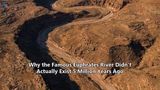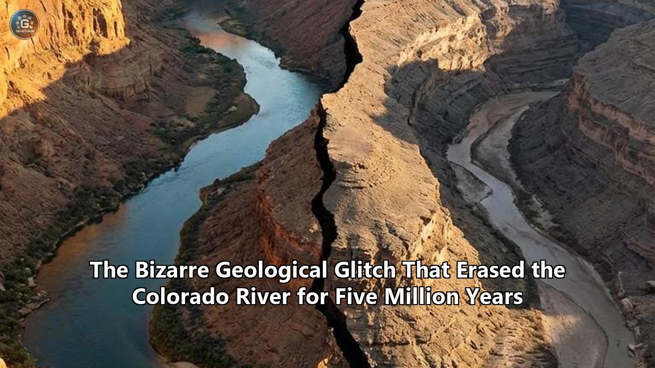
The physical measurements of the Colorado River have long presented geologists with an irreconcilable mathematical discrepancy. Measuring 1,450 miles in length and draining a massive portion of the Rocky Mountains, the river currently carves through the American West with a kinetic energy capable of stripping up to 525 feet of bedrock every million years. Yet, when hydrogeologists attempted to map the sediment record of this continental waterway, they ran into a massive temporal void.
Data confirms the ancestral river existed in western Colorado 11 million years ago. Separate data confirms the river suddenly exited the Grand Canyon and arrived at the Gulf of California between 5.0 and 5.6 million years ago. Between these two data points lay a staggering five-million-year gap where the river simply vanished from the geological record. The sediment, the water, and the erosional footprint effectively ceased to exist in the established stratigraphic models.
This week, a research team led by UCLA geologists and the U.S. Geological Survey published a study in the journal Science that finally quantifies exactly where the missing river went. Using detrital zircon geochronology and sediment source mapping, the researchers discovered that the Colorado River did not flow aimlessly across the plateau. Instead, its flow was entirely arrested by a massive topographic barrier known as the Kaibab Arch. Blocked from proceeding westward, millions of acre-feet of water pooled into a colossal, previously unmapped natural reservoir—ancient Lake Bidahochi—situated on what is now Navajo Nation land just east of the Grand Canyon.
The river flowed into this closed basin for five million years, accumulating sediment and volume until a catastrophic spillover event breached the plateau and triggered the sudden, aggressive incision of the Grand Canyon.
"In some ways, you could really think of it as the birth of the Colorado River that we know today," said UCLA geologist and the study's first author, John He. "There are rivers everywhere, but a river that carries water and sediment across the continent connects life throughout the region, and the entire ecosystem probably changed as a result of the arrival of the Colorado River into the basin."
This discovery recalibrates the Colorado River geological history, replacing fragmented hypotheses with a unified, data-backed model of continental drainage integration.
The 5-Million-Year Hydrogeological Glitch
To understand the scale of the missing time, one must evaluate the raw volumetric output of a river system. A continental river continuously transports dissolved solids, suspended sediment, and bedload. If a river flows for five million years, it must deposit millions of tons of material somewhere.
"A longstanding question has been: where did the Colorado River go before it flowed through Grand Canyon?" said Ryan Crow, a research geologist at the U.S. Geological Survey in Flagstaff, Arizona, and co-lead author of the study. "We have long known that the river existed in western Colorado 11 million years ago, and that it did not (run through) Grand Canyon until after 5.6 million years ago. But until now we knew almost nothing about where it was during the intervening time."
The temporal glitch centered on the Kaibab Arch, a structural uplift of sedimentary rock in northern Arizona and southern Utah. This topographical high posed a rigid geographic barrier. The elevation grades strictly prohibited the river from continuing its descent toward the Pacific.
Prior to this newly published data, researchers lacked the quantitative tools to prove exactly how the river bypassed this ancient upwarp. "Geologists have proposed over a dozen hypotheses for the canyon's formation and the Colorado River's path," said co-author John Douglass, a geologist at Paradise Valley Community College.
The primary models included:
- Antecedent drainage: The river was already in place before the Kaibab Arch uplifted, cutting through the rock as it rose. (This was invalidated by dating the uplift, which predated the river).
- Headward erosion: A smaller, lower-elevation stream carved backward (eastward) into the plateau until it intersected and captured the ancestral Colorado River.
- Lake spillover: The river flowed into a closed basin until the water level exceeded the lowest point of the surrounding topography, causing a cascading breach.
The new data heavily supports the lake spillover model, supplemented by localized elements of karst piping—subterranean water transport through soluble rock—and headward erosion. By quantifying the exact age and origin of sediment trapped east of the canyon, the researchers proved the lake theory mathematically viable.
Zircon Chronometers: Quantifying the Sediment Provenance
Solving a million-year-old hydrogeological blind spot required analyzing particles no larger than the width of a human hair. The research team utilized detrital zircon geochronology to trace the exact lineage of the sandstone deposits located east-southeast of the Grand Canyon.
Zircon (zirconium silicate) is highly resistant to chemical weathering and mechanical destruction. When igneous rocks crystallize, zircons trap trace amounts of uranium and thorium, while strongly rejecting lead. Over millions of years, the radioactive isotopes decay into lead at a known, constant rate. By measuring the ratio of uranium to lead isotopes via mass spectrometry, geochronologists can pinpoint the exact age the crystal formed.
When tracking the Colorado River geological history, these zircons act as immutable geographic barcodes. The Rocky Mountains produce a specific age-signature of zircon. If those specific Rocky Mountain zircons appear in sedimentary layers hundreds of miles away, analysts can map the exact path the water took to carry them there.
He, Douglass, and Emma Heitmann, a hydrogeology doctoral student at the University of Washington, collected sandstone samples from the eroded remnants of the Bidahochi Formation. By isolating the detrital zircons within these deposits, the mass spectrometry results yielded a definitive match. The zircons found in the ancient lakebed perfectly aligned with the isotopic signatures of the ancestral Colorado River headwaters.
This quantitative match provided the hard evidence needed. The river had not bypassed the region or flowed underground undetected; it had been emptying its entire payload directly into the Bidahochi basin for 5,000 millennia.
The Dimensions of Ancient Lake Bidahochi
Reconstructing Lake Bidahochi requires projecting current topographic data backward to account for millions of years of erosion. Based on the distribution of the Bidahochi Formation's sedimentary rocks, researchers estimate this late Miocene reservoir achieved massive proportions.
The lake pooled across what is currently Navajo Nation territory, potentially reaching widths of more than 90 miles (150 kilometers). For context, this surface area rivals some of the largest modern freshwater lakes in North America.
The stratigraphy of the Bidahochi basin shows a clear transition in depositional environments. The lower layers contain fine-grained lacustrine mudstones, indicative of deep, still water. As the timeline progresses toward the 5.6-million-year mark, the sediment profile abruptly shifts.
The upper layers feature stark, high-energy ripple marks in the sandstone. These ripples are not formed by gentle wave action; they require the consistent, unidirectional kinetic force of a major river discharging massive volumes of water and heavy sediment into the basin. The sedimentary geometry confirms that the Colorado River was actively filling the lake to its absolute volumetric capacity.
As the water level rose, it eventually met the lowest topographic divide on the Kaibab Arch. The hydrostatic pressure and continuous inflow from the Rocky Mountains initiated a breach.
The Spillover Event and the 330-Foot-Per-Million-Year Buzzsaw
At approximately 5.6 million years ago, Lake Bidahochi overtopped its western boundary. What followed was a highly localized, high-velocity erosional event that initiated the carving of the Grand Canyon.
Water flowing over a steep gradient possesses extreme kinetic energy, allowing it to transport abrasive bedload (boulders, cobbles, and sand). This bedload acts as a mechanical buzzsaw against the bedrock.
"Past work shows that over the last million years the Colorado River has been carving into rock at an average rate of about 100 meters to 160 meters (330 to 525 feet) per million years, so the process of canyon carving continues," Crow explained.
By analyzing the current dimensions of the Grand Canyon—280 miles long, up to 18 miles wide, and over 6,100 feet (1,860 meters) deep—geologists can reverse-engineer the erosion rates. If the river removes roughly 330 to 525 feet of rock per million years, achieving a 6,100-foot depth aligns perfectly with the 5.6-million-year spillover timeline established by the zircon data.
The sudden integration of the river network had immediate downstream consequences. Once the river punched through the Kaibab Arch, it rapidly filled and spilled through a subsequent series of lower-elevation basins downstream from the Grand Canyon, ultimately reaching the Gulf of California about 4.8 to 5.0 million years ago.
The stratigraphic proof of this downstream arrival is located in the Bouse Formation, a sequence of limestone and fine-grained clastic strata in the lower Colorado River Valley. Isotopic analysis of the Bouse carbonates perfectly matches the strontium-isotope signature of modern Colorado River water, providing a geochemical timestamp for the exact era the river finally reached the sea.
Biological Cross-Verification: Fossil Ecosystem Dynamics
The physical measurements provided by isotopic dating are strictly corroborated by the biological record. A major shift in regional hydrology triggers immediate, quantifiable changes in local biomass and species distribution.
Paleontologists analyzing the Bidahochi Formation uncovered a distinct biostratigraphic shift that mirrors the zircon data. Embedded within the rippled rock layers—the exact layers indicating the arrival of fast-flowing water—are the fossilized remains of large fish species.
The skeletal morphology of these fish indicates they were uniquely adapted to highly oxygenated, fast-moving river currents, not stagnant lake water. The sudden appearance of these specific fossil phenotypes in the upper stratigraphy of the Navajo Nation basin cross-verifies the hydrogeological timeline provided by the UCLA researchers.
This biological integration marks a pivotal moment in the Colorado River geological history. Prior to the spillover, aquatic species in the Rocky Mountains were genetically isolated from the species in the lower desert basins. The breaching of the Kaibab Arch created a 1,450-mile contiguous biological corridor. Genetic material, nutrients, and migratory species could travel freely from the high-altitude alpine zones down to the marine estuary of the Gulf of California.
The river transitioned from an isolated drainage system into a continental lifeline. The sediment transported by the river began building the massive Colorado River Delta in Mexico, establishing the foundation for one of the most biologically dense wetland ecosystems in the hemisphere.
Resolving the Next Million Years of Hydrological Evolution
The resolution of the five-million-year glitch provides researchers with the precise metrics needed to model the future trajectory of the Colorado Plateau. The forces that created the Grand Canyon are not static; they operate as highly active, quantifiable variables in an ongoing geological equation.
The Colorado Plateau continues to experience tectonic uplift. As the landmass slowly rises, it steepens the gradient of the Colorado River, thereby increasing water velocity and subsequent erosion rates. The river is currently engaged in an ongoing mechanism of vertical adjustment, balancing the tectonic forces pushing the bedrock upward against the hydrological forces cutting it downward.
Current models project that the river will continue incising the canyon floor at the established rate of 330 to 525 feet per million years, provided water flow remains constant. Human intervention, however, introduces immediate, short-term variables that disrupt deep-time geological projections.
The construction of the Glen Canyon Dam and the Hoover Dam in the 20th century fundamentally altered the river's sediment transport capacity. By trapping millions of tons of sediment behind concrete barriers, human infrastructure has stripped the river of its primary erosive tool—its abrasive bedload. Downstream of the dams, the water runs artificially clear, severely reducing its ability to cut bedrock.
Simultaneously, severe multi-decadal droughts are reducing the aggregate volume of water flowing through the basin. While these variations register as microscopic anomalies on a geological timescale, they drastically impact the short-term morphological evolution of the canyon network.
For scientists tracking the Colorado River geological history, the focus now shifts to the remaining stratigraphic ambiguities. While the Bidahochi spillover explains the primary integration of the upper and lower basins, the precise sequencing of the downstream lakes—how fast the water breached the localized divides in the Mohave and Sonoran deserts—requires further mapping.
Geologists are increasingly utilizing scientific drilling programs to extract deep-core samples from the Bouse Formation and the surrounding desert basins. By recovering continuous, unweathered sediment cores, researchers aim to run higher-resolution paleomagnetic and isotopic analyses. These future datasets will dictate exactly how many millennia it took for the spilled river to tear through the remaining topography and hit the ocean.
The discovery of the Bidahochi pooling event closes the largest structural gap in North American hydrology. It replaces a five-million-year question mark with a rigorously tested, statistically verifiable model of landscape evolution. The Colorado River did not vanish; it simply waited behind a wall of stone, pooling its volume until it gathered the critical mass required to cut a wonder of the world.
Reference:
- https://newsroom.ucla.edu/releases/how-colorado-river-got-to-grand-canyon
- https://www.hawaiitribune-herald.com/2026/04/18/nation-world-news/scientists-decipher-the-geological-history-of-the-grand-canyon/amp/
- https://scienmag.com/the-colorado-river-vanished-from-the-geological-record-for-5-million-years-scientists-have-finally-traced-its-lost-path/
- https://gizmodo.com/geologists-uncover-a-hidden-path-that-the-colorado-river-hasnt-taken-in-5-6-million-years-2000747886
- https://www.iflscience.com/scientists-solve-mystery-of-why-the-colorado-river-disappeared-from-the-geological-record-for-5-million-years-83234
- https://www.researchgate.net/publication/287571557_The_Bouse_Formation_and_post-Miocene_uplift_of_the_Colorado_Plateau
- https://science.nasa.gov/earth/earth-observatory/the-colorado-river-cuts-a-canyon-150622/
- https://www.pbs.org/wgbh/nova/transcripts/1914raft.html
- https://www.usgs.gov/publications/a-river-born-highlights-geologic-evolution-colorado-river-extensional-corridor-and-its
- https://www.usgs.gov/publications/bouse-formation-a-controversial-neogene-archive-evolving-colorado-river-a-scientific