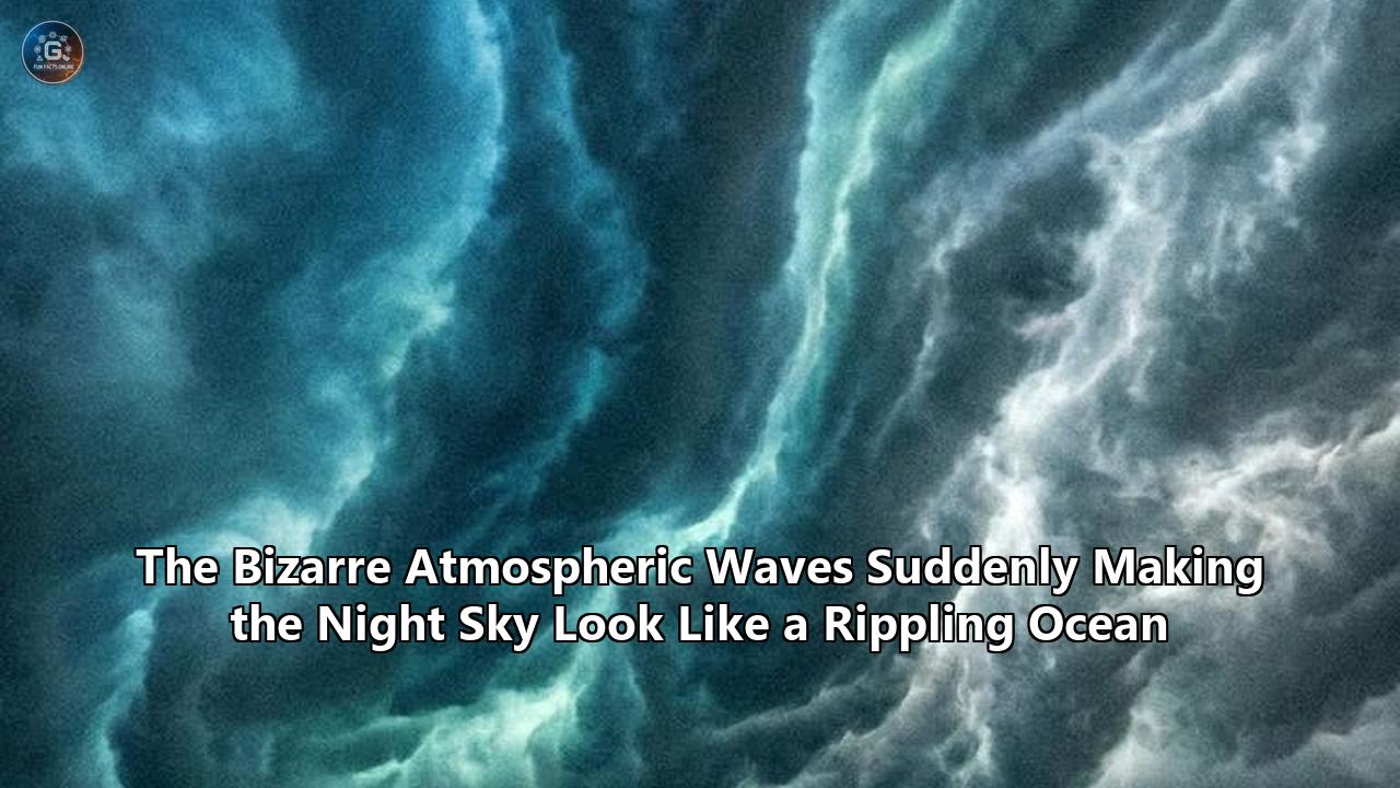
On April 26, 2026, observers across the Hawaiian archipelago looked up to find the night sky completely transformed. Instead of the usual rigid blanket of stars, the heavens appeared to be undulating, washing across the darkness in massive, glowing green ripples. It looked exactly like the surface of a disturbed ocean, hanging 50 miles above the Pacific. Concurrent with these ground observations, NASA’s Visible Infrared Imaging Radiometer Suite (VIIRS) satellite system captured the event from above using its highly sensitive Day/Night Band. According to a multi-sensor analysis published shortly after by physical oceanographer Dr. Edwin Alfonso-Sosa, the luminous bands stretching across the Pacific were not meteorological clouds, but a massive display of mesospheric airglow triggered by underlying thermal forcing.
Hawaii was not an isolated incident. Over the last twelve months, astrophotographers and automated skyward cameras have captured identical, bizarrely beautiful phenomena with increasing frequency. In May 2025, Colorado-based photographer Aaron Watson caught vivid, watery green ripples sweeping from south to north across the Milky Way, completely invisible to the naked eye but brightly apparent in long-exposure timelapses. Similar footage emerged from Mount Rainier in Washington State, where glowing concentric rings warped the darkness above Lake Tipsoo.
We are witnessing the visual manifestation of one of the Earth's most powerful, invisible engines. These glowing ripples are the direct result of atmospheric gravity waves, a fluid dynamics phenomenon that transports massive amounts of energy from the surface of the Earth to the edge of space. Now, armed with unprecedented data from the International Space Station, scientists are finally decoding how these violent vertical disturbances dictate global weather patterns, disrupt satellite operations, and blur the line between Earth’s atmosphere and the vacuum of space.
The Physics of Atmospheric Ripples
To understand why the night sky is suddenly mirroring a rippling ocean, we first need to strip away a common point of confusion. The structures warping the air over Hawaii and Colorado are not gravitational waves—the ripples in the fabric of spacetime caused by merging black holes or neutron stars that physicists measure with facilities like LIGO. Instead, atmospheric gravity waves are a classical fluid dynamics mechanism where gravity acts as the restoring force for a displaced parcel of air.
The atmosphere is a stratified fluid. Dense air sits at the bottom, and lighter, thinner air sits at the top. When a massive disturbance occurs near the Earth's surface—such as a severe thunderstorm updraft, the sheer force of a Category 5 hurricane, a volcanic eruption, or even high-speed winds slamming into a jagged obstacle like the Andes or the Cascade mountain range—it physically shoves a massive pocket of air upward into a higher, less dense atmospheric layer.
Because this displaced air is heavier than the surrounding environment at that new altitude, gravity immediately pulls it back down. However, the momentum of the falling air parcel causes it to overshoot its original equilibrium point, sinking too low. Now surrounded by denser air, buoyancy forces it back up. The air parcel begins to bounce up and down, oscillating vertically. As this oscillation continues, it generates a transverse wave that propagates outward and upward through the atmospheric column, expanding for thousands of miles.
The mechanics mirror what happens when you drop a stone into a still pond, but translated into a three-dimensional gaseous environment. Furthermore, as these waves travel higher into the stratosphere and mesosphere, the atmospheric density drops exponentially. To conserve kinetic energy, the amplitude of the wave must increase. A slight, localized ripple generated by a thunderstorm over the Great Plains might grow into a massive, towering atmospheric wave with vertical displacements of several kilometers by the time it reaches the upper atmosphere.
Planetary scientists frequently observe extreme versions of this mechanism elsewhere in the solar system. In recent years, researchers utilizing Japan’s Akatsuki orbiter discovered a 6,000-kilometer-wide atmospheric wave front sweeping around the equator of Venus. Using fluid dynamic models, scientists linked the Venusian anomaly to a massive "hydraulic jump"—a process where fast-moving fluid abruptly slows and piles up, forcing an immense vertical wave. Earth’s atmospheric gravity waves operate on similar principles, acting as the primary elevator for kinetic energy traveling from the turbulent troposphere into the calm stability of the upper atmosphere.
Chemiluminescence: Lighting Up the Invisible
If these waves are composed of nothing but oscillating air, why are they suddenly appearing as brilliant green ripples in nighttime photography? The answer lies in a continuous, chemical phenomenon known as airglow.
Unlike auroras, which are driven by charged solar wind particles funneling down the Earth's magnetic field lines and colliding with atmospheric gases at the poles, airglow is happening everywhere, all the time. It is the result of chemiluminescence—a slow, light-emitting chemical reaction driven by the delayed release of solar energy.
During the daylight hours, the Earth’s upper atmosphere is bombarded by intense ultraviolet radiation from the sun. This UV radiation is strong enough to break apart molecular oxygen (O2) into individual oxygen atoms (O) at altitudes roughly 62 miles (100 kilometers) above the surface. These individual atoms cannot hold onto this excited state forever, but in the thin air of the thermosphere, it takes hours for them to find a partner.
As night falls, the oxygen atoms finally begin to collide and recombine back into O2 molecules. This recombination process releases a specific quantum of energy in the form of a photon. The most dominant and visible emission in this process produces a distinct green light at a wavelength of 557.7 nanometers. Other layers produce different wavelengths: a hydroxyl (OH) layer at roughly 87 kilometers produces infrared light, a sodium layer at 90 kilometers produces a faint yellow, and an upper oxygen layer at 96 kilometers produces red light. Combined, these reactions generate a faint, perpetual luminescence that is roughly a billion times fainter than daylight.
Under normal conditions, airglow appears as a smooth, uniform, featureless wash of faint light near the horizon. But when an atmospheric gravity wave propagates upward and passes through these specific altitude bands, it violently distorts the gas.
As the peak of the wave compresses the air in the mesosphere, it forces the oxygen atoms closer together. This adiabatic compression raises the local temperature and dramatically increases the rate of chemical recombination, resulting in a bright, intense band of green or infrared light. Conversely, as the trough of the wave expands the air, the density and temperature drop, slowing the chemical reaction and creating a dark band.
When astrophotographers like Aaron Watson point their cameras upward during a severe weather outbreak, they are not photographing the wave itself. They are photographing the alternating compression and expansion of the airglow layer, manifesting as giant glowing ripples flowing across the night sky. It is a rare visual proxy for a massive kinetic energy transfer happening at the very edge of space.
The AWE Mission: NASA's Staring Contest with the Mesosphere
For decades, the mesosphere and lower thermosphere—the regions where these waves peak and break—were derisively referred to by some researchers as the "ignorosphere." At 50 to 85 kilometers above the Earth's surface, the air is too thin to support weather balloons or research aircraft, but it remains entirely too thick to maintain the orbits of satellites, which would burn up from atmospheric drag. Because it was so difficult to measure, scientists lacked the data to understand exactly how energy from the lower atmosphere mixed with the space environment.
That changed in November 2023 with the launch of the Atmospheric Waves Experiment (AWE), a dedicated NASA payload attached to the exterior of the International Space Station. Built by the Space Dynamics Laboratory at Utah State University, the AWE mission was designed with a single, highly specific purpose: to map and characterize small-scale atmospheric gravity waves on a global level.
The mission is the culmination of decades of work, heavily championed by the late Dr. Mike Taylor, an atmospheric physics visionary at Utah State University who passed away in mid-2025. Taylor spent years traveling to remote corners of the globe, photographing wave structures from the ground before realizing that a space-based, downward-looking instrument was the only way to capture the true global scale of the phenomenon.
Operating from its vantage point on the ISS, AWE does not look for the visible green oxygen layer. Instead, it utilizes an Advanced Mesospheric Temperature Mapper (AMTM) to stare into the infrared spectrum. The instrument consists of four identical telescopes combined to create a 90-degree wide field of view, generating a massive 600-kilometer swath width as the space station orbits the Earth.
The AMTM is equipped with highly precise narrowband filters centered at 1524 and 1542 nanometers. These wavelengths specifically isolate the hydroxyl (OH) airglow layer sitting 87 kilometers above the surface. By measuring the relative brightness of this infrared light, AWE creates highly accurate, real-time temperature maps of the mesopause. The resolution is unprecedented. While previous legacy satellites could only detect massive, continent-spanning waves, AWE is capable of resolving short-scale ripples driven by highly localized terrestrial events, measuring their size, power, and dispersion with extreme fidelity.
In early 2025 and progressing through 2026, the AWE science team released its first massive data sets after completing over 3,000 orbits. The release contained over five million images and temperature swaths. Among the most striking early findings were direct observations of enormous gravity waves radiating outward from Hurricane Helene in late 2024 as the storm slammed into the Gulf Coast. The data provided a concrete, visual link proving that terrestrial weather violence directly dictating upper atmospheric turbulence.
Satellite Drag and The Trillion-Dollar Space Economy
The sudden surge in data surrounding these invisible ripples is not simply a matter of academic curiosity. It is an economic imperative. As the commercialization of Low Earth Orbit (LEO) accelerates, understanding the thermal expansion of the upper atmosphere has become crucial for protecting billions of dollars in orbital assets.
When atmospheric gravity waves reach the upper thermosphere, the decreasing air density means they can no longer maintain their structure. The waves "break," exactly like ocean waves crashing against a shoreline. When they break, they abruptly dump all the kinetic energy and momentum they carried up from the troposphere into the surrounding environment.
This energy deposition acts as a massive heating mechanism. When the upper atmosphere absorbs this heat, the gas expands outward into space. Suddenly, a satellite orbiting smoothly at 300 miles above the Earth finds itself plowing through a much thicker layer of atmospheric particles.
This phenomenon, known as satellite drag, is one of the most unpredictable variables in space operations. Increased drag strips orbital velocity from satellites, causing their orbits to decay prematurely. In severe cases, satellites can be pulled completely out of orbit and burn up upon reentry, a fate that befell dozens of Starlink satellites during an unexpected density surge a few years ago. To counteract this drag, satellite operators must burn limited onboard propellant to boost their assets back into higher orbits. Miscalculating the drag environment by even a few percentage points can shave years off a multi-million dollar satellite's operational lifespan.
Historically, satellite operators looked primarily to space weather—specifically solar flares and coronal mass ejections—to predict upper atmospheric expansion. The AWE mission data fundamentally alters this equation. It proves that terrestrial weather events—such as deep convection storms in the Midwest, typhoons in the Pacific, or massive polar vortex shifts—are firing atmospheric gravity waves upward, heating the thermosphere from below. Without mapping and predicting these waves, satellite operators are flying blind to half of the forces determining orbital decay.
GPS Scintillation and Ionospheric Turbulence
Beyond orbital mechanics, the breaking of these waves introduces severe turbulence into the ionosphere, a highly active layer of Earth's atmosphere filled with free electrons and ions. This region is the primary medium through which modern global communications operate.
Every time you open a mapping application on a smartphone, an aircraft shoots a landing approach, or a maritime shipping vessel navigates a strait, they rely on a constellation of GPS satellites broadcasting microwave signals down to Earth. These signals must travel through the ionosphere.
When an atmospheric gravity wave breaks in the thermosphere, it physically churns the plasma, creating localized bubbles and dense ripples of electrons. As GPS signals pass through these turbulent density pockets, the radio waves are refracted and scattered. This scattering causes the signal to rapidly fluctuate in amplitude and phase—a phenomenon known as ionospheric scintillation.
In mild cases, scintillation causes a GPS receiver to lose a few meters of accuracy. In severe cases, particularly when terrestrial gravity waves interact with high solar activity, the receiver can suffer a complete loss of lock, meaning the navigational system goes entirely blind. For modern precision agriculture, which relies on centimeter-level GPS accuracy to guide automated combine harvesters, or for the aviation sector executing automated runway approaches in low visibility, a loss of lock is a critical hazard.
The turbulence also wreaks havoc on high-frequency (HF) radio communications, which rely on bouncing radio waves off a smooth ionosphere to communicate over the horizon. When the ionosphere is heavily rippled by breaking gravity waves, the HF signals scatter chaotically into space rather than reflecting back to the ground, causing sudden communications blackouts for military operators and intercontinental flights over the poles.
By processing the millions of images beamed down from the AWE mission, researchers at Utah State University and NASA are developing new predictive software. The goal is to correlate tropospheric weather models with upper-atmospheric disturbances, eventually allowing aviation authorities and satellite operators to issue targeted alerts for GPS degradation based on the localized weather systems developing far below.
Bridging the Gap in Global Climate Models
The implications of tracking these waves stretch downward just as aggressively as they stretch upward. To predict the Earth's changing climate, scientists rely on highly complex General Circulation Models (GCMs). These models mathematically divide the Earth's atmosphere into a three-dimensional grid, calculating how heat, moisture, and momentum transfer between each box over decades.
The primary flaw in current GCMs is resolution. The grid boxes in these models are typically tens to hundreds of kilometers wide. Small-scale atmospheric gravity waves—which may only have horizontal wavelengths of a few kilometers—slip entirely through the mathematical cracks. Because the models cannot natively "see" the smaller waves, they fail to account for the massive amount of energy those waves transport away from the surface and up into the stratosphere.
To compensate, climate scientists rely on "parameterization"—essentially creating a mathematically educated guess of how much energy the waves are moving based on bulk meteorological data. If the parameterization is inaccurate, the error compounds over time, leading to significant deviations in long-term climate projections, particularly regarding polar vortex stability, stratospheric warming events, and the shifting of the jet streams.
The 2026 data pipeline from the ISS is offering climate modelers the exact ground-truth measurements they have been missing. By quantifying the exact size, frequency, and energy load of the waves triggered by specific terrains and storm systems, researchers can replace rough estimations with hard physics. Machine learning models are already being trained on the AWE data to better parameterize these waves in traditional GCMs, refining our ability to predict severe weather outbreaks and model the localized impacts of a warming troposphere over the next century.
The Blurring Boundary Between Earth and Space
The stunning imagery of green ripples washing over the Hawaiian Islands and the rugged peaks of the American West is forcing a fundamental shift in how the scientific community views the Earth.
Historically, meteorologists looked down, focusing strictly on the troposphere where rain, snow, and hurricanes dominate. Space physicists looked up, fixating on the solar wind, magnetic reconnection, and the aurora. The mesosphere and lower thermosphere served as an ignored buffer zone between the two disciplines.
The visual documentation of atmospheric gravity waves has demolished that boundary. It is now irrefutably clear that the Earth's atmospheric column is a single, deeply interconnected system. A thunderstorm over the Great Plains does not just dump rain on the surface; it fires a kinetic shockwave into the vacuum of space, altering the drag on commercial satellites and shifting the electron density of the ionosphere. Conversely, the thermal expansion caused by this energy transfer alters the pressure gradients high above the poles, which eventually trickles down to influence the trajectory of the jet stream steering the very storms that started the cycle.
As 2026 progresses, the dynamics of this system will only become more volatile. We are operating deep within a highly active solar maximum, meaning the upper atmosphere is simultaneously being bombarded with intense energy from above via auroral heating, and massive kinetic energy from below via gravity waves generated by an increasingly energetic, warming lower atmosphere.
Future missions are already being proposed to follow in AWE's footsteps, aiming to build a permanent, real-time observational network of the mesopause. Until those constellations launch, astrophotographers and orbital radiometers will keep their lenses pointed at the darkness, watching for the subtle, glowing ripples that prove just how violently the sky is moving directly above our heads.
Reference:
- https://www.space.com/stargazing/photographer-captures-ghostly-ripples-over-colorado-night-sky-it-is-rare-to-see-it-directly-overhead-and-moving-like-that-photo
- https://www.researchgate.net/publication/404531454_Multi-Sensor_Analysis_of_a_Mesospheric_Airglow_Event_over_the_Hawaiian_Archipelago_on_April_26_2026
- https://universemagazine.com/en/scientists-create-autotune-for-gravitational-wave-detectors/
- https://www.404media.co/scientists-just-got-an-unprecedented-glimpse-into-the-nature-of-reality/
- https://www.reddit.com/r/spaceporn/comments/1n4679c/airglow_ripples_caused_by_atmospheric_gravity/
- https://www.pnas.org/doi/10.1073/pnas.1508084112
- https://www.miguelclaro.com/wp/portfolio/rainbow-bands-of-airglow-in-gravity-waves-above-pico-island/
- https://astrobiology.com/2026/05/venus-atmosphere-jumps-and-waves.html
- https://eos.org/research-spotlights/gravity-waves-leave-ripples-across-a-glowing-night-sky
- https://www.eoportal.org/satellite-missions/iss-awe
- https://spacedaily.com/awe-launching-to-space-station-to-study-atmospheric-waves-via-airglow-999/
- https://quantumzeitgeist.com/nasa-releases-data-from-awe-missions-first-3000-orbits-shedding-light-on-atmospheric-waves-and-space-weather/