Today, a multinational coalition of marine biologists and oceanographers published a high-resolution, contiguous biological map confirming the exact dimensions of a massive, 600-mile coral reef system completely concealed beneath the muddy outflow of the Amazon River. Spanning 3,600 square miles from the coast of French Guiana to Brazil’s Maranhão state, the data released today transforms what was once a patchy, localized scientific curiosity into one of the most structurally complex and biologically defiant ecosystems on Earth.
The publication of this definitive mapping arrives at a highly volatile moment. Just weeks ago, in early January 2026, an offshore exploratory rig operated by the Brazilian state-run oil giant Petrobras suffered a mechanical failure, leaking 18 cubic meters of synthetic drilling fluid at a depth of more than 9,000 feet in the Foz do Amazonas basin. The incident forced Brazil’s National Agency of Petroleum, Natural Gas and Biofuels (ANP) to mandate a total halt on drilling operations until environmental impact reports are fully audited.
The collision of these two events—the definitive scientific codification of an unprecedented deep-water biome and the immediate industrial threat looming over it—has ignited a multifaceted geopolitical, scientific, and corporate conflict. To understand the stakes of this standoff, one must look past the superficial environmental versus industrial talking points and examine the exact biological mechanics, the acoustic technology required to map a lightless world, and the bureaucratic warfare currently paralyzing Brazil’s energy sector.
The Oceanographic Anomaly of the Equatorial Margin
For over a century, a foundational tenet of marine biology dictated that major river systems create localized marine "dead zones" where coral structures cannot physically manifest. Reef-building corals require very specific parameters to survive: high salinity, neutral to basic pH levels, low nutrient loads to prevent algal dominance, and, most crucially, clear water to allow sunlight to reach the symbiotic zooxanthellae algae residing within the coral tissue.
The mouth of the Amazon River violently violates every one of these conditions. Discharging roughly 20% of the entire global riverine freshwater supply into the Atlantic Ocean, the Amazon ejects up to 300,000 cubic meters of water per second during peak flood seasons. This massive expulsion carries millions of tons of suspended sediment, terrestrial organic matter, and dissolved silicates. As this freshwater hits the ocean, it does not immediately mix. Instead, because freshwater is significantly less dense than saltwater, the Amazon outflow overrides the Atlantic water, creating a massive, muddy surface layer known as a riverine plume.
This plume acts as an opaque, geological roof, blocking out nearly all sunlight and dramatically altering the surface chemistry of the ocean for hundreds of miles. Under traditional oceanographic models, the seafloor beneath this plume should be an impoverished, muddy wasteland dominated by scavengers and bacterial mats.
Yet, the mapping data finalized today definitively proves the exact opposite. Hidden beneath the halocline—the sharp boundary where the dark, fresh surface water meets the dense, highly saline, and relatively clear oceanic water underneath—is a thriving, calcified metropolis. The Amazon River coral reef exists entirely in this subterranean oceanic layer, completely insulated from the chaotic riverine discharge churning just dozens of meters above it. It is a biome that operates on an inverted biological hierarchy, challenging everything researchers thought they knew about reef formation and resilience.
Navigating the Mud: Acoustic Telemetry and Deep-Water Robotics
The sheer existence of the reef begs an obvious question: how did a 600-mile, 3,600-square-mile geographical feature remain undetected until the 21st century?
The answer lies in the physics of remote sensing. Modern oceanography heavily relies on multispectral satellite imagery to detect the optical signatures of shallow-water reefs. Satellites easily map the Great Barrier Reef or the Maldives because the water is optically transparent. Over the Amazon Equatorial Margin, satellites only see the thick, impenetrable brown stain of the river plume.
Hints of the reef's existence date back to the 1970s when dredging vessels occasionally pulled up fragments of calcareous algae, reef fish, and sponges. However, without precise GPS coordinates and the technology to see beneath the sediment layer, these findings were largely dismissed as anomalies or debris swept in by deep ocean currents.
The breakthrough that led to today's mapping relied on replacing light with sound. Because optical cameras on traditional Remotely Operated Vehicles (ROVs) are rendered useless by the complete lack of visibility in the upper water column, researchers deployed a fleet of Autonomous Underwater Vehicles (AUVs) equipped with high-frequency multibeam echosounders.
These sonar systems cast a fan of acoustic pings down toward the seafloor. By measuring the precise time it takes for the acoustic wave to bounce back to the receiver, the AUVs can calculate the depth and topographical relief of the ocean floor. More importantly, by measuring the "backscatter"—the amplitude or strength of the returning echo—scientists can determine the physical density of the seabed. Soft river mud absorbs sound, returning a weak signal; hard, calcified coral and rhodolith beds reflect sound sharply, returning a strong signal.
Over the past several years, culminating in today’s release, AUVs mapped the entire 600-mile corridor at depths ranging from 30 to 120 meters. The resulting bathymetric models revealed an immense network of carbonate ridges, deep ravines, and towering sponge communities that align precisely with the trajectory of the North Brazil Current, sweeping northwest along the South American continental shelf.
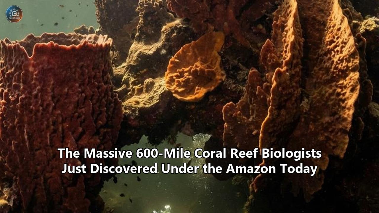
The Benthic Architecture: Sponges, Corals, and Detritivores
What the acoustic maps and subsequent deep-water sampling revealed is an ecosystem sharply divided into distinct northern and southern sectors, dictated entirely by the thickness of the Amazon plume hovering above it.
In the southern sector, closer to the Brazilian state of Maranhão, the river plume is relatively thin. During specific seasons, the shifting currents allow a dappled, twilight level of sunlight to penetrate the water column. Here, researchers cataloged true stony corals (Scleractinia), massive beds of calcified red algae known as rhodoliths, and a familiar, albeit light-starved, array of traditional reef architecture.
However, as the reef extends northward toward Amapá and French Guiana, the plume thickens, plunging the ecosystem into near-total darkness. In this sector, the primary reef builders transition away from photosynthetic corals to massive, towering sea sponges and deep-water gorgonians (sea fans).
The biological inventory published today confirms a staggering level of biodiversity for a light-deprived environment. The reef supports over 61 distinct species of sponges, some growing as large as small cars, and at least 73 species of fish, including predatory snappers, moray eels, and herbivorous parrotfish. It is also highly populated by spiny lobsters, sea stars, and brittle stars.
If there is virtually no sunlight for photosynthesis in the northern sector, what forms the base of the food web? Biologists have discovered that this ecosystem relies heavily on the very phenomenon that should have killed it. The Amazon River carries an immense amount of terrestrial organic matter—decaying leaves, wood, and soils from the rainforest. As this material reaches the ocean, it sinks through the halocline in a process known as "marine snow." The giant sponges and gorgonians act as highly efficient biological filters, capturing this falling organic debris. Furthermore, researchers have identified localized bacterial communities engaging in chemosynthesis, processing dissolved minerals into energy.
The reef, therefore, is not a mistake; it is an incredibly specialized, highly adapted machine designed to feed off the refuse of the world’s largest rainforest.
Molecular Immunity and the Turbid Refuge Hypothesis
One of the most critical aspects of this discovery is what it tells us about coral resilience in the face of anthropogenic climate change. Across the globe, from the Great Barrier Reef to the Florida Keys, shallow-water corals are experiencing catastrophic bleaching events triggered by rising sea surface temperatures and increased ultraviolet radiation.
Yet, the Amazon River coral reef appears entirely insulated from these specific threats. The muddy plume that blocks the sun also acts as a massive thermal and radiological shield. It significantly reduces the water temperature beneath the halocline and entirely blocks the ultraviolet radiation that exacerbates coral bleaching.
Furthermore, surviving in this punishing, sediment-heavy environment has forced the local species to evolve remarkable biochemical defenses. Recent molecular analysis by researchers at San Diego State University has revealed that corals possess ancient immunological responses dating back 550 million years. These organisms deploy Platelet-Activating Factors (PAF)—a molecule strikingly similar to those found in the human immune system. When the corals undergo stress, such as aggressive algal takeover, physical abrasion from sediment, or pathogenic loads dropped by the river water, their PAF production spikes, launching a targeted immune response to clear the damage and maintain tissue integrity.
This has led marine biologists to propose the "Turbid Refuge Hypothesis." As global sea surface temperatures continue to rise, shallow, clear-water reefs may face near-total extinction. Turbid environments—areas previously ignored by conservationists because they are considered "dirty" or "impoverished"—might actually serve as the final climate sanctuaries for coral genetics.
However, the tragic irony of the Amazon reef is that precisely as its potential as a global climate refuge is proven, it faces an immediate, localized industrial threat that its ancient immune systems cannot combat.
The Guyana Allure and the Anatomy of an Oil Lease
To understand why offshore drilling rigs are currently positioned above this delicate ecosystem, one must look hundreds of miles to the north, to the territorial waters of Guyana.
Starting in 2015, a consortium led by ExxonMobil discovered vast, highly pressurized reservoirs of high-quality crude oil in the Guyana-Suriname basin. Over the last decade, these discoveries have accumulated to an estimated 11 billion barrels of recoverable oil, transforming Guyana's economy overnight and establishing the region as the most lucrative new oil frontier on the planet.
Geologists quickly realized that the sedimentary basins off the coast of Guyana share a direct geological continuity with Brazil's northern coast—a region known as the Equatorial Margin. Millions of years ago, as the South American and African tectonic plates tore apart during the Cretaceous period, they left behind deep, structurally identical rifts along this margin. If Exxon found 11 billion barrels in the northern section of the rift, the Brazilian government and international oil majors bet billions that similar reserves were trapped beneath the Foz do Amazonas basin.
The corporate scramble began in 2013 during Brazil's 11th bidding round for oil and gas exploration. A consortium led by French major TotalEnergies (then Total SA), alongside British Petroleum (BP) and Brazil's Queiroz Galvão, paid approximately $196 million (622 million reais) to secure exploration rights in five blocks situated roughly 120 kilometers offshore.
However, they immediately ran into a regulatory buzzsaw. The Brazilian Institute of Environment and Renewable Natural Resources (IBAMA) demanded rigorous environmental impact assessments, specifically concerning the fluid dynamics of an oil spill. The North Brazil Current is remarkably powerful. Hydrodynamic modeling showed that if a deep-water blowout occurred, the crude oil would not simply float out to sea. The currents would likely drag the toxic slick directly over the submerged reef, push it northward into the territorial waters of French Guiana, and wash it ashore onto the Brazilian state of Amapá.
Amapá’s coastline contains the largest continuous belt of pristine mangroves in the world. An oil slick washing into this tidal labyrinth would be fundamentally impossible to clean, devastating the breeding grounds for countless marine species and annihilating the livelihoods of the local Quilombola (Afro-Brazilian descent communities) and indigenous fishing populations.
After years of submitting revised environmental models—and facing mounting public pressure spearheaded by Greenpeace and local NGOs—TotalEnergies officially abandoned its operatorship of the blocks in 2020. BP followed suit. Petrobras, eager to unlock what it views as a strategic national reserve essential for funding Brazil’s long-term energy transition, absorbed the operatorship and took on the environmental licensing battle itself.
The January 2026 Petrobras Leak at 9,000 Feet
Petrobras spent years lobbying the government and revising its spill containment strategies. By late 2025, operating under intense political pressure from the Ministry of Mines and Energy, the company managed to initiate exploratory drilling in Block FZA-M-59, roughly 100 miles off the coast. The well was highly ambitious, pushing drill bits through complex geology at water depths exceeding 9,000 feet.
Then, the exact scenario environmentalists had warned about for a decade began to materialize.
On January 4, 2026, sensors on the drilling rig indicated a sudden drop in pressure and fluid volume within the wellbore. Drilling at extreme depths requires the constant circulation of "drilling mud"—a heavy, synthetic fluid pumped down the drill pipe to lubricate the bit, carry rock cuttings back to the surface, and crucially, maintain hydrostatic pressure to prevent highly pressurized gas and oil from causing a catastrophic blowout.
Initial reports from Petrobras indicated that 15 cubic meters of this synthetic fluid had leaked out of the well system and into the ocean. However, highly sensitive internal documents reviewed by regulators and later leaked to Reuters revealed that the spill was larger than initially reported—totaling 18 cubic meters (23.54 cubic yards). Furthermore, during closed-door meetings with the ANP in early January, Petrobras officials admitted they could not definitively identify the root cause of the mechanical failure.
Petrobras rapidly issued public statements attempting to minimize the crisis, asserting that the leak was contained, that the synthetic fluid was biodegradable, and that it posed no immediate harm to human life or the marine environment.
Deep-sea benthic ecologists vehemently dispute this characterization. Synthetic drilling fluids, even those labeled "biodegradable," are dense, chemically complex mixtures containing barite, synthetic base oils, and various surfactants. When released at 9,000 feet, these fluids do not simply dissolve harmlessly. They create a heavy, toxic subsurface plume that sinks and spreads along the seafloor currents.
For the Amazon River coral reef, which sits on the continental shelf adjacent to these deeper blocks, the threat is existential. The ecosystem is uniquely dominated by filter-feeding sponges. If a subsurface current drags particulate-laden drilling fluid over the reef, the sponges will actively pump the toxic material into their vascular systems. Unlike fish, which can swim away from a localized spill, the sessile corals and sponges cannot retreat. The drilling fluid clogs their filtration matrices, smothers the polyps, and introduces acute chemical toxicity that their ancient PAF immune molecules are fundamentally unequipped to neutralize.
Bureaucratic Warfare and the Precautionary Principle
The January 2026 leak triggered immediate and severe administrative action. The ANP suspended Petrobras’s drilling license for the Foz do Amazonas basin, demanding a comprehensive root-cause analysis and the implementation of foolproof mitigation measures before the drill bits are allowed to turn again.
This suspension has exposed a deep, ideological rift fracturing the administration of Brazilian President Luiz Inácio Lula da Silva. On one side of the battlefield is the Ministry of Mines and Energy, deeply aligned with Petrobras and a coalition of northern politicians who view the Equatorial Margin as Amapá's ticket to economic prosperity. They argue that Brazil must exploit its deep-water reserves to maintain energy independence and generate the sovereign wealth required to eventually fund a transition to renewable energy.
On the other side is the Ministry of Environment and Climate Change, overseen by Marina Silva, a globally recognized environmentalist with a history of fiercely opposing unchecked industrial expansion in the Amazon. Her ministry oversees IBAMA, the agency historically responsible for blocking Total and BP. IBAMA operates heavily on the "Precautionary Principle"—a legal and philosophical mandate stating that if an action has a suspected risk of causing severe harm to the public or the environment, the burden of proof that it is not harmful falls entirely on those taking the action.
The publication of today’s exhaustive mapping of the reef serves as a massive legal weapon for the Ministry of Environment. Previously, Petrobras could argue that the exact borders of the reef were ill-defined and that their drilling blocks were sufficiently distanced from any sensitive benthic zones. The new data eradicates that plausible deniability. It clearly demonstrates that the ecological footprint of the reef is far more expansive and interconnected than previously modeled, placing Petrobras’s logistical supply lines and potential spill zones in direct conflict with the ecosystem.
The Mangrove Shield and Coastal Litigation
While the federal agencies battle in Brasília, a localized legal war is being waged on the coast. The environmental risks of the Foz do Amazonas drilling do not end at the ocean floor.
A coalition formed by Greenpeace Brazil, indigenous movements, Quilombola communities, and artisanal fishermen associations recently filed a sprawling lawsuit in the Federal Court against IBAMA, Petrobras, and the Brazilian State. The plaintiffs point to the January leak as undeniable proof of the inherent risks of deep-water exploration in this highly volatile oceanographic zone.
The legal foundation of their lawsuit rests heavily on the failure of the corporate and state entities to conduct adequate community consultation. Under international frameworks, specifically the International Labour Organization (ILO) Convention 169, which Brazil has ratified, indigenous and traditional communities must be thoroughly consulted before any industrial activity occurs that could impact their ancestral territories or livelihoods.
The fishermen of Amapá rely on the nutrient-rich waters fueled by the Amazon plume. The mangrove forests serve as the nurseries for the commercial fish and crustacean stocks that feed the region. The Greenpeace vessel, the MV Witness, spent the early weeks of 2026 conducting the "Protect the Amazon Coast Expedition," documenting the intricate reliance of these coastal communities on a healthy, unpolluted ocean.
The plaintiffs argue that the environmental impact studies supplied by Petrobras grossly underestimated the velocity and sheer force of the North Brazil Current. If the blowout preventer on the Foz do Amazonas well had failed completely in January, releasing crude oil instead of synthetic mud, the current would have inevitably driven the slick into the mangrove belt. Oil acts as an asphyxiant in mangroves, coating the aerial pneumatophores (the specialized root structures the trees use to breathe). Once oil enters a mangrove root system, the forest rapidly dies, causing the coastline to collapse and eradicating the marine nursery.
The Horizon: Unresolved Tensions and Upcoming Milestones
As the data regarding the Amazon River coral reef circulates through global academic and regulatory networks today, the immediate future of the Equatorial Margin remains in a state of suspended animation.
The next major flashpoint is imminent. The ANP is scheduled to conduct a physical inspection of the Petrobras drilling rig in late February 2026. The outcome of this inspection will dictate the short-term trajectory of Brazil's oil ambitions. If Petrobras can convince the ANP that the 18-cubic-meter leak was an isolated anomaly and that their blowout preventers are mathematically infallible, the drilling suspension could be lifted. If they fail to provide adequate technical assurances, the rig may be ordered back to port, bleeding millions of dollars in day-rates and potentially killing the Foz do Amazonas project for the remainder of the decade.
Simultaneously, the biological confirmation of the reef has accelerated a push by international marine conservation groups to formally petition the Brazilian government to establish a sprawling Marine Protected Area (MPA) encompassing the entire 600-mile stretch. Classifying the reef as an MPA would permanently ban exploratory drilling, dredging, and commercial bottom-trawling within its borders.
However, implementing an MPA over an area heavily earmarked for national economic expansion would require immense political capital, something the current administration is rapidly depleting as it balances environmental pledges with the harsh economic realities of a developing nation.
What the biologists accomplished today is a triumph of acoustic engineering and marine persistence. They have illuminated a world that thrives in the dark, feeding off the decay of the rainforest and protected by an ancient biological immune system. They have proven that the ocean still holds vast, uncharted territories capable of upending established scientific paradigms.
The question now shifts from oceanography to policy. The map is drawn, the coordinates are fixed, and the biological value is undeniable. As the drilling rigs sit idle and the fluid dynamics of the Amazon plume continue to shroud the ocean floor, the international community watches to see whether Brazil will prioritize the extraction of ancient carbon or the preservation of an ecosystem uniquely positioned to survive a warming world. The legal rulings and mechanical inspections of the coming weeks will likely decide the fate of a hidden metropolis that spent thousands of years growing in the dark, only to face its greatest existential threat the moment it was finally brought into the light.
Reference:
- https://www.miragenews.com/amazon-leak-halts-petrobras-drilling-operations-1599281/
- https://krro.com/2026/01/08/brazils-oil-regulator-puts-petrobras-drilling-at-foz-do-amazonas-on-hold/
- https://www.mirror.co.uk/news/world-news/amazon-river-coral-reef-found-7816077
- https://intotheamazonriver.weebly.com/coral-reefs.html
- https://avagierek.weebly.com/current-events-blog
- https://www.livescience.com/54524-amazon-river-coral-reef-discovered.html
- https://www.techtimes.com/articles/154099/20160427/coral-reefs-have-molecular-protection-similar-to-the-human-immune-system.htm
- https://gulfnews.com/business/energy/totals-plans-for-brazils-new-oil-frontier-snagged-on-amazon-reef-1.2026659