High atop the desolate, dark volcanic peaks of the Hudson Mountains in West Antarctica, a geological anomaly has baffled researchers for decades. Scattered across the jagged, black basalt surface sat massive boulders of vibrant pink granite. They did not belong there. The surrounding geology offered no logical source for this crystalline, rosy rock, leaving scientists to question how these massive stones were transported to such an isolated elevation.
Now, that mystery has been solved, and the answer has unveiled a staggering geological colossus.
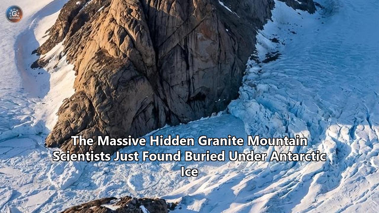
A team of researchers led by the British Antarctic Survey (BAS) has confirmed the discovery of an enormous, hidden granite landmass lurking entirely beneath the Pine Island Glacier. Measuring nearly 100 kilometers (62 miles) across and extending up to 7 kilometers (4.3 miles) thick, this subterranean titan is roughly half the size of Wales. It represents one of the most significant subglacial discoveries of the decade, completely remapping our understanding of the bedrock that dictates the flow of one of Earth’s most vulnerable ice sheets.
The identification of this massive buried mountain under antarctica was not just an exercise in mapping a static, frozen landscape. It is an urgent breakthrough in climate science. The Pine Island Glacier is currently one of the fastest-melting bodies of ice on the planet. By determining the exact topography and geological makeup of the bedrock sliding beneath it, researchers can now drastically refine the predictive computer models that forecast global sea-level rise over the coming centuries.
The Pink Clues on the Black Volcanoes
The story of this discovery begins with the erratic boulders themselves. In glaciology, an "erratic" is a piece of rock that has been transported by ice and deposited in an area with a different underlying geology. When geologists first surveyed the Hudson Mountains, the pink granite blocks stood out in stark visual contrast to the surrounding dark volcanic rock.
Granite forms from the slow crystallization of magma below the Earth's surface. It requires a specific set of tectonic and thermal conditions to materialize—conditions entirely detached from the relatively recent volcanic activity that formed the Hudson peaks. For years, scientists understood that an ancient ice sheet must have plucked these boulders from a distant source and deposited them at high elevations, but the location of the "mother lode" remained completely obscured by miles of solid ice.
To find the source, the BAS deployed a specialized Twin Otter aircraft. Flying treacherous, low-altitude grid patterns over the seemingly endless white expanse of the Pine Island Glacier, the aircraft was equipped with advanced gravimeters and magnetometers. Because humans cannot physically dig through kilometers of ice to observe the bedrock, geophysicists must weigh the Earth from the sky.
Granite is generally less dense than the mantle rocks and dense volcanic basalts that often make up ocean-adjacent crust, but it possesses a highly distinct gravitational and magnetic signature compared to surrounding sedimentary basins. As the Twin Otter flew over a specific region of the glacier, the instruments recorded a massive gravitational anomaly—a vast, localized shift in the pull of gravity. The data perfectly matched the density signature of a colossal granite batholith hiding in the dark, effectively acting as the missing source for the pink boulders downstream.
Reading the Zircon Clocks: A Jurassic Birth
Locating the structure was only half the battle; the team needed to understand its age to place it within the tectonic history of the continent. Researchers utilized U-Pb (Uranium-Lead) zircon geochronology on samples taken from the pink boulders. Zircon crystals are microscopic time capsules. When they form within cooling magma, they incorporate uranium but strongly reject lead. Therefore, any lead found inside a zircon crystal today is the direct result of the radioactive decay of that uranium.
Because uranium decays at a strictly known, constant rate, researchers can calculate the exact age of the rock by measuring the ratio of uranium isotopes to lead isotopes. The results from the Hudson Mountain boulders confirmed that the granite crystallized approximately 175 million years ago.
This places the formation of the subglacial mountain squarely in the Jurassic Period. During this era, Antarctica was not the frozen, inhospitable desert we know today. It was a central piece of the supercontinent Gondwana, situated closer to the equator, and featured a temperate climate. The landscape was draped in dense forests of conifers and ferns, supporting robust ecosystems that included early long-necked sauropodomorphs like Glacialisaurus and apex predators such as the crested Cryolophosaurus.
The granite mass formed deep underground during a period of intense tectonic activity as magma intruded into the Earth’s crust, slowly cooling over millennia into a massive pluton. Over millions of years, as tectonic plates shifted and Gondwana tore apart, Antarctica drifted southward. By the time the continent froze over entirely around 34 million years ago, this massive granite dome had been exposed by millions of years of surface erosion, only to be swallowed whole by the advancing East and West Antarctic Ice Sheets.
The Mechanics of Glacial Plucking and Transport
Connecting the 175-million-year-old subterranean mass to the surface boulders requires understanding the brutal physics of glacial ice. A glacier is not a static block of frozen water; it is a massive, slow-moving river of high-pressure ice that behaves almost like a highly viscous fluid over geological timescales.
At the base of a glacier, the sheer weight of kilometers of ice exerts immense pressure on the bedrock. Where the ice meets the rock, friction and geothermal heat can create a thin layer of liquid water. As the glacier grinds forward, water forces its way into the cracks and fissures of the granite bedrock. When this subglacial water refreezes, it expands, shattering the rock in a process known as freeze-thaw weathering. The moving ice then "plucks" these shattered blocks of granite from the bedrock, incorporating them into the lower layers of the glacier.
During the Last Glacial Maximum, approximately 20,000 years ago, the West Antarctic Ice Sheet was vastly thicker and extended much further than it does today. The Pine Island Glacier flowed directly over the hidden granite massive, plucking the pink boulders from its highest peaks. The ice then acted as a conveyor belt, carrying the heavy stones downstream. As the climate slowly warmed and the ice sheet thinned over the ensuing millennia, the glacier lost its carrying capacity. The ice retreated and melted, stranding the pink boulders high on the slopes of the Hudson Mountains, leaving behind a breadcrumb trail that scientists would follow tens of thousands of years later.
Dr. Tom Jordan, the lead author of the study and a geophysicist at the British Antarctic Survey, emphasized the utility of these stranded rocks. By mapping exactly where the boulders were dropped and calculating the distance from the newly discovered subglacial source, geophysicists can reconstruct the exact flow pathways, speed, and thickness of the ice sheet during the Last Glacial Maximum.
The Vulnerable Underbelly: Climate Implications
While uncovering a Jurassic granite massif is a triumph of geological sleuthing, its true significance lies in what it means for the immediate future of global coastlines.
The Pine Island Glacier, along with its neighbor the Thwaites Glacier, forms the vulnerable underbelly of the West Antarctic Ice Sheet. Together, they act as massive frozen dams, holding back enough inland ice to raise global sea levels by several meters if they were to collapse entirely. Currently, Pine Island is experiencing some of the most rapid ice loss recorded anywhere on the continent. Warm ocean currents are undercutting the ice shelf, causing the glacier's grounding line—the point where the ice detaches from the bedrock and begins to float—to retreat inland at an alarming pace.
The speed at which a glacier flows into the ocean is directly controlled by the basal friction between the ice and the bedrock. Moving ice slides very differently over a hard, rigid surface like solid granite compared to soft, deformable marine sedimentary basins. Granite resists the flow. It acts as a massive speed bump, creating localized friction that can slow the catastrophic drainage of inland ice into the Amundsen Sea.
Furthermore, subglacial hydrology—how meltwater routes itself beneath the ice—is heavily dependent on bedrock topography. A solid, 7-kilometer-thick block of granite forces subglacial water to flow around it or pool in specific basins. Because pressurized water acts as a lubricant that accelerates glacial sliding, knowing exactly where the water is forced to travel is essential for accurate flow modeling.
Before this discovery, climate models simulating the future of the Pine Island Glacier had to rely on generalized assumptions about the basal topography in this region. The confirmation of a massive, hard-rock barrier alters the mathematical equations dictating ice flow. Every newly mapped buried mountain under antarctica refines our understanding of basal friction, allowing glaciologists to run highly accurate, high-resolution simulations. By knowing the precise dimensions and rock type of this subglacial giant, researchers can better predict whether Pine Island will continue its steady acceleration or if the newly discovered topography will act as a stabilizing anchor in the decades to come.
A Continent of Hidden Peaks: Comparing Subglacial Giants
The discovery beneath Pine Island is the latest in a growing catalog of massive topographic features mapped beneath the ice, proving that the continent is a highly complex, rugged terrain rather than a flat, frozen basin.
The Gamburtsev Enigma
To understand the scale of Antarctica's hidden geology, one must look to the center of the continent, where the largest buried mountain under antarctica currently resides: the Gamburtsev Subglacial Mountains. First detected in 1958 by a Soviet expedition relying on rudimentary seismic readings, the Gamburtsevs remain one of the least understood tectonic features on Earth.
Completely entombed beneath up to 3.1 kilometers (1.9 miles) of the East Antarctic Ice Sheet, the Gamburtsev range stretches for 1,200 kilometers (745 miles) and boasts jagged alpine peaks soaring to 3,400 meters (11,155 feet). They are roughly the size and shape of the European Alps, yet no human eye has ever seen them.
For decades, the Gamburtsevs posed an impossible geologic paradox. Mountains typically form at the active margins of tectonic plates where landmasses collide, thrusting rock into the sky. But the interior of East Antarctica has been tectonically stable for hundreds of millions of years. Additionally, massive mountain ranges are subjected to the relentless forces of erosion—wind, rain, and glaciation eventually grind them down into rolling hills, as seen with the ancient Appalachian Mountains in North America. How could an Alpine-scale mountain range exist in the middle of a dead tectonic plate, retaining razor-sharp peaks as if they were formed yesterday?
Recent research published in Earth and Planetary Science Letters by geologists at the University of Tasmania and Macquarie University has finally unraveled this mystery. Similar to the British Antarctic Survey’s work in West Antarctica, these researchers could not directly sample the buried bedrock. Instead, they relied on sedimentary deposits carried to the coast by ancient rivers long before the ice took hold. By isolating tiny zircon crystals from these coastal sediments and dating them, the team reconstructed a staggering timeline.
The Gamburtsev Mountains were forged over 500 million years ago during the catastrophic assembly of the supercontinent Gondwana. As ancient landmasses—including what would become India, Africa, Australia, and Antarctica—slammed together, the crust was violently compressed, creating a towering mountain range. Over time, the massive weight of these early peaks caused the crustal root beneath them to heat up and become unstable, leading to a gravitational collapse. The mountains essentially sank, preserving a dense, deep crustal root.
Hundreds of millions of years later, as Gondwana rifted apart, the continental crust stretched and thinned, allowing that buoyant, ancient root to rebound upward, lifting the modern Gamburtsev peaks back into the sky just before the continent froze over. The sudden onset of glaciation approximately 34 million years ago effectively flash-froze the mountains, acting as a deep-freeze preservative that protected the sharp peaks from the destructive forces of wind and water erosion for millions of years.
Ancient Rivers and Frozen Time Capsules
The ice does more than preserve mountains; it suspends entire ecosystems in time. Operating concurrently with the BAS gravity flights, researchers utilizing the Canadian satellite RADARSAT recently uncovered a remarkably preserved pre-glacial landscape hidden beneath the ice in East Antarctica.
Led by Stewart Jamieson from Durham University, scientists detected minute, subtle undulations in the surface of the ice sheet. Because ice slowly flows over the bedrock, the surface of the ice faintly mimics the topography thousands of meters below. By analyzing these subtle surface textures, Jamieson's team mapped a buried landmass roughly the size of New Jersey, complete with perfectly preserved, winding ancient riverbeds and deep valleys.
This landscape was carved out by flowing water over 34 million years ago, during the transition period when the Earth's climate rapidly cooled and the Antarctic ice sheets first began to form. The fast-advancing ice filled the river valleys and covered the hills without scraping them away, effectively locking a snapshot of prehistoric Earth inside a frozen vault.
These parallel discoveries—a Jurassic granite massif in the West, the 500-million-year-old Gamburtsev peaks in the East, and a 34-million-year-old river basin—demonstrate how advanced remote sensing is effectively peeling back the ice. Antarctica is no longer viewed as a blank slate of bedrock, but as a diverse, complex continent whose deeply buried geometry exerts a daily, active influence on the behavior of the ice above it.
The Limits of Airborne Radar and Gravity Metrics
While the recent identification of the massive granite structure beneath Pine Island represents a masterclass in geophysics, the methodology highlights the extreme difficulties of studying the Antarctic subsurface.
Researchers rely on three primary tools to map the bedrock:
- Radar Echo Sounding (RES): Emitting low-frequency radio waves that penetrate the ice and bounce off the bedrock. This provides excellent data on ice thickness and the physical shape of the topography.
- Gravimetry: Measuring localized shifts in the Earth's gravitational pull. Dense rock (like basalt) exerts slightly more gravity than lighter rock (like granite or sediment).
- Magnetometry: Measuring anomalies in the Earth's magnetic field to identify iron-rich volcanic rocks versus non-magnetic sedimentary basins.
Combining these datasets allows geologists to infer the composition of the bedrock. When radar shows a solid mound, gravity shows a low-density mass, and magnetics show a weak signature, the logical deduction is a massive granite batholith.
However, remote sensing remains indirect. The only way to achieve absolute certainty regarding the chemical composition, precise age, and structural integrity of subglacial rock is through physical sampling. Drilling through thousands of meters of flowing, high-pressure ice requires millions of dollars, immense logistical support, and years of planning. Hot-water drilling and mechanical coring have been achieved in relatively shallow or static regions, such as the successful extraction of sediment from Subglacial Lake Mercer, but drilling into the rugged, fast-moving terrain beneath the Pine Island Glacier remains a formidable engineering hurdle.
The strategy of tracing erratics—like the pink boulders of the Hudson Mountains—bridges the gap between airborne modeling and physical sampling. It is a rare instance where the glacier essentially does the drilling and excavation for the scientists, delivering deep-bedrock samples directly to the surface.
Looking Forward: The Next Decade of Subglacial Exploration
The successful mapping of the massive granite body beneath the Pine Island Glacier fundamentally alters the immediate agenda for glaciologists and climate scientists. The task now shifts from discovery to integration.
In the immediate future, researchers must feed these updated topographic and geological parameters into the Ice Sheet System Model (ISSM) and other global climate simulators. By adjusting the basal friction coefficients to account for 100 kilometers of solid granite, scientists will observe how the simulated ice reacts over timelines of 50, 100, and 500 years. If the models show that the granite acts as an effective brake on the glacier's retreat, it may revise our timelines for worst-case-scenario sea-level rise. Conversely, if the topography channels warm subglacial meltwater in ways that accelerate basal sliding, the threat may be more acute than previously calculated.
Looking toward the next phase of physical exploration, space agencies and polar institutes are preparing a new generation of observational tools. The upcoming deployment of advanced autonomous underwater vehicles (AUVs) capable of swimming miles beneath the floating ice shelves will provide unprecedented views of the grounding lines where the ice meets the rock. Furthermore, machine learning algorithms are being trained on existing satellite and Twin Otter data to detect subtle gravitational and radar anomalies that human analysts may have missed, potentially identifying entirely new subglacial mountain ranges across the continent.
The Antarctic ice sheet is the largest single variable in predicting the future of the global coastline. For decades, the bedrock beneath it was treated as a black box—a mysterious, unreachable surface. The discovery of this monumental Jurassic granite structure, alongside the mapping of the Gamburtsev range and ancient subglacial riverbeds, proves that the black box is finally opening.
The terrain beneath the ice is dynamic, ancient, and deeply varied. As researchers continue to fly their radar grids across the frozen expanse, tracking gravity anomalies and tracing pink boulders back to their hidden origins, the true face of the southern continent will slowly come into focus. The geological secrets locked beneath the ice for tens of millions of years are no longer just artifacts of Earth's distant past; they are the key to predicting its immediate future.
Reference:
- https://www.bas.ac.uk/news/hidden-giant-granite-discovered-beneath-west-antarctic-ice-sheet/
- https://phys.org/visualstories/2025-10-hidden-giant-granite-beneath-west.amp
- https://www.indy100.com/science-tech/pink-boulders-underworld-antarctic-mountin
- https://scitechdaily.com/mysterious-pink-rocks-expose-a-massive-secret-buried-under-antarcticas-ice/
- https://www.discoverwildlife.com/environment/granite-bedrock-pine-island-glacier
- https://www.iflscience.com/a-giant-mountain-range-has-been-hidden-under-antarcticas-ice-for-millions-of-years-79186
- https://www.youtube.com/watch?v=RhSyUs3LeJQ
- https://en.as.com/latest_news/the-tiny-world-from-34-million-years-ago-discovered-under-antarctica-its-like-a-time-capsule-f202601-n/
- https://www.earth.com/news/hidden-mountain-range-under-antarctica-is-older-than-dinosaurs/
- https://www.utas.edu.au/about/news-and-stories/articles/2025/antarctica-has-a-huge,-completely-hidden-mountain-range.-new-data-reveals-its-birth-over-500-million-years-ago
- https://glassalmanac.com/invisible-mountains-uncovered-scientists-finally-reveal-the-500-million-year-old-secret-hidden-beneath-antarctic-ice/