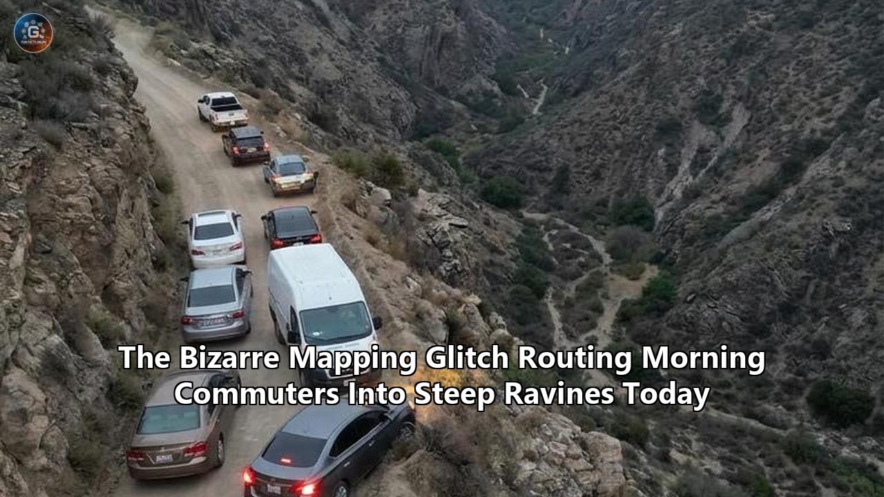
The morning commute along the Interstate 90 corridor east of Seattle abruptly transformed into a high-stakes wilderness rescue operation early Wednesday morning. Following a minor rockslide that blocked the westbound lanes near Snoqualmie Pass at 5:15 a.m., tens of thousands of drivers relied on their smartphone navigation apps to find an alternate route. Instead of safely bypassing the debris, a localized algorithmic glitch directed more than eighty vehicles—ranging from low-clearance electric sedans to heavy commercial delivery vans—off the paved highway and straight into the precipitous, unpaved logging paths of the Tiger Mountain ravine.
By 6:30 a.m., the scene resembled a vehicular trap. A line of cars, blindly following the glowing blue lines on their dashboards, had descended down a 25-percent dirt grade intended only for heavy forestry equipment. Because the trail narrowed drastically between sheer rock faces and dense pine coverage, the vehicles could not turn around. When the lead cars bottomed out in a washed-out creek bed, the traffic stacked up behind them. Drivers found themselves immobilized at dangerous angles, unable to reverse up the slick, muddy incline.
King County Search and Rescue, alongside multiple local fire departments, spent seven hours extracting furious commuters and their abandoned vehicles from the backcountry. Tow trucks could not safely access the lower portion of the ravine, forcing crews to use heavy-duty winches anchored to old-growth trees just to drag stranded sedans back to the pavement.
This was not a case of a single confused driver making a wrong turn. It was a synchronized, mass-scale routing failure triggered by a silent overnight update to the mapping data utilized by several major navigation platforms. As municipalities increasingly grapple with the chaotic fallout of automated routing algorithms, Wednesday's mass stranding highlights a severe vulnerability in the digital infrastructure we trust to guide our daily lives. The incident exposes the fragile intersection between cloud-based pathfinding mathematics and the unforgiving reality of physical topography.
The Anatomy of the May 6 Glitch
To understand how dozens of rational adults simultaneously drove their vehicles into a dangerous wilderness ravine, one must examine the mechanics of modern digital pathfinding. Routing engines operate on graph theory, treating the road network as a series of nodes (intersections) and edges (road segments). Each edge is assigned a "weight," which represents the cost of traversing that segment. This cost is calculated using speed limits, historical traffic data, distance, and surface types.
During the overnight hours leading into Wednesday, a rolling update was applied to the regional metadata governing the Tiger Mountain area. According to preliminary incident reports from spatial data analysts observing the region, a critical tagging error occurred during this update. The specific two-mile stretch of logging road descending into the ravine was inadvertently stripped of its surface=unpaved and access=forestry metadata tags.
Without these exclusionary tags, the algorithm defaulted to treating the path as a standard municipal road with a presumed speed limit of 35 miles per hour. When the rockslide halted traffic on Interstate 90, the routing engine detected a massive spike in the "cost" of staying on the highway. Seeking the path of least resistance, the algorithm queried the surrounding network. It found the newly updated, untagged logging road, which mathematically appeared as a pristine, empty bypass entirely free of traffic.
The first vehicle to take the detour unknowingly triggered a disastrous feedback loop. Modern navigation applications rely heavily on real-time probe data—the GPS telemetry beamed back from users' phones. As the first driver cautiously navigated the top of the logging road at 10 miles per hour, the system registered that a device was successfully moving along the alternate route. To the algorithm, this confirmed the route was viable.
By the time the lead vehicle became hopelessly wedged in the washed-out creek bed at the bottom of the ravine, the routing engine had already diverted eighty more cars behind it. The system interpreted the slow speeds not as a sign of hazardous terrain, but merely as heavy traffic on a valid bypass, continually recalculating and reaffirming the route for users miles away. It took direct intervention from the Washington State Patrol, who physically barricaded the entrance to the trail with a cruiser and flares, to stop the influx of misdirected traffic.
The Psychology of the Blue Line
The physical extraction of the vehicles is only half the story; the psychological component of this incident is equally critical. Why do experienced, licensed drivers look through their windshields at a plunging, unpaved ravine and press the accelerator anyway?
Cognitive psychologists refer to this phenomenon as "automation bias," a heuristic where humans tend to favor suggestions from automated decision-making systems over contradictory information coming from their own senses. When a driver is navigating a stressful situation—such as a dark, early-morning commute interrupted by a highway closure—their cognitive load spikes. To manage this stress, the brain offloads the navigational responsibility entirely to the software.
Dr. Aris Vlahos, a human-factors researcher who studies transportation interfaces, notes that modern navigation apps are specifically designed to command absolute authority. "The user interface offers no uncertainty," Vlahos explained following a similar incident last year. "The software doesn't tell you, 'I have a 60 percent confidence rating that this dirt path connects to the highway.' It presents a solid, bold blue line and instructs you to turn with definitive audio cues. When humans are stressed and rushed, they defer to that absolute authority, even when their headlights are illuminating a sheer drop-off."
This uncritical acceptance creates what safety experts chillingly call "Death by GPS." While Wednesday's event ended without fatalities, emergency rooms and search-and-rescue teams globally are intimately familiar with the consequences of automation bias. Drivers routinely ignore physical warning signs, concrete barriers, and worsening road conditions because the screen on their dashboard assures them they are just minutes away from their destination. By the time the driver realizes the environment is entirely hostile to their vehicle, it is usually too late to reverse course.
A Historical Pattern of Algorithmic Failures
Wednesday's mass stranding in Washington State is not an isolated anomaly. It is the latest escalation in a long, documented history of severe GPS navigation errors that have strained municipal resources and cost lives. The mapping industry has consistently struggled to reconcile abstract digital coordinates with complex physical realities.
In April 2025, a driver in East Java, Indonesia, plummeted 40 feet from an unfinished highway overpass after his navigation app routed him past concrete security barriers and directly off the edge of the incomplete bridge. The driver survived, but the incident highlighted the perilous lag between physical construction realities and cloud-based map updates.
Similarly, the Scottish mountain conservation charity John Muir Trust waged a public battle against digital mapping providers after algorithms began directing casual tourists up potentially fatal, pathless routes on Ben Nevis, Scotland's highest peak. The system simply connected the closest parking lot to the summit with a dotted line, oblivious to the fact that the resulting route led directly over sheer cliffs that challenged even experienced mountaineers.
In the United States, rural search and rescue teams have spent years begging the public to ignore their phones. The California Highway Patrol frequently issues warnings regarding Donner Pass, where navigation software regularly attempts to route winter drivers off the safety of Interstate 80 and onto treacherous, unplowed mountain passes to save a few minutes of traffic time. In 2024, a Utah motorist was stranded for hours on the rocky, deserted slopes of Strawberry Peak after following a recommended "shortcut" between Springville and Vernal.
What makes Wednesday's incident in the Tiger Mountain ravine uniquely alarming is the scale. Historically, GPS navigation errors have primarily affected isolated travelers venturing into unfamiliar territory. This morning, the glitch weaponized a standard suburban commute, actively trapping dozens of local residents who were simply trying to reach their offices in Seattle. The algorithmic failure bypassed individual error and created a systemic hazard.
Technological Blindspots in the Mapping Ecosystem
The fundamental challenge in preventing these routing disasters lies in the way digital maps are constructed and maintained. The modern digital map is not a single, static document. It is a composite of dozens of overlapping data layers, constantly updated by automated web scrapers, municipal data feeds, satellite imagery analysis, and crowdsourced user reports.
This complexity breeds vulnerability. Satellite imagery, while incredibly detailed, struggles to identify the nuanced physical condition of a road. From an orbital perspective, a 25-percent grade logging trail obscured by a heavy pine canopy looks nearly identical to a paved, narrow county road. Computer vision algorithms designed to extract road networks from satellite photos frequently misclassify these trails as passable routes.
Furthermore, the data supply chain is heavily reliant on crowdsourced edits and open-source data repositories like OpenStreetMap (OSM). While OSM is a triumph of collaborative data mapping, it is susceptible to human error and deliberate vandalism. A single user with editing privileges can alter the metadata of a road segment. If large commercial routing engines automatically ingest these updates without adequate friction or physical verification, a digital typo instantly alters the physical flow of traffic.
The delay in municipal reporting further compounds the issue. When a road washes out, or a temporary barrier is erected, the physical world changes instantly. However, local departments of transportation often lack a standardized, real-time method for broadcasting these closures to technology companies. Unless a critical mass of drivers reports the closure within the app, the algorithm continues to view the road as open, actively punishing drivers by funneling them toward the hazard.
The Legal and Liability Landscape
As the last of the mud-caked vehicles were towed out of the Tiger Mountain ravine Wednesday afternoon, questions of liability immediately surfaced. Who bears the financial responsibility for thousands of dollars in property damage, missed work, and the massive deployment of municipal emergency resources?
Historically, technology companies have shielded themselves behind robust Terms of Service agreements. These user agreements explicitly state that mapping directions are provided for planning purposes only and that the driver assumes all responsibility for adhering to physical traffic signs and assessing road conditions. When a driver drives into a lake or down a ravine, the legal defense typically relies on the argument of driver negligence: a reasonable person should have looked out the windshield and hit the brakes.
However, the legal tide is beginning to shift. Legal scholars argue that as routing algorithms transition from passive maps to active, turn-by-turn commanders that penalize users for deviating from the route (through constant "recalculating" alerts), the liability profile changes.
In late 2022, a North Carolina man drowned when his navigation app directed him to drive across a bridge that had collapsed years prior. The family filed a lawsuit against the mapping provider, arguing that local residents had repeatedly reported the collapsed bridge to the company, yet the algorithm continued to use the route. The core legal argument hinges on gross negligence rather than simple software malfunction. If a company receives data indicating a route is deadly, but their system continues to dispatch users to that route, the traditional Terms of Service defense begins to look legally fragile.
Wednesday's mass event amplifies this legal jeopardy. This was not a single driver making a poor judgment call; it was an algorithmic dispatch that created a public nuisance and endangered emergency responders. Municipalities, weary of footing the bill for expensive technical extractions, are beginning to explore mechanisms to hold routing providers financially accountable for negligent algorithm deployments that drain local public safety budgets.
Direct Municipal Interventions
Recognizing that they cannot wait for Silicon Valley to perfect its pathfinding algorithms, local governments and emergency leaders are actively building their own defensive infrastructure against aggressive routing software. The solution framework emerging in 2026 focuses heavily on asserting municipal control over digital traffic flows.
The most prominent tool being deployed is the concept of "digital geofencing." Cities and county transportation departments are developing proprietary software portals that integrate directly with the APIs of major mapping providers. When an emergency event occurs—such as Wednesday's rockslide on Interstate 90—dispatchers can draw a digital polygon over the affected area and the surrounding vulnerable side streets. This geofence forces an absolute, non-negotiable routing penalty into the commercial algorithms, completely blinding the apps to the restricted roads.
The town of Leonia, New Jersey, pioneered early versions of this concept years ago by physically closing streets to non-residents to combat navigation apps routing thousands of bridge-avoiding commuters through their quiet neighborhoods. Today, the approach is entirely digital. By establishing direct, authenticated channels between 911 dispatch centers and mapping data aggregators, local authorities bypass the slow, crowdsourced reporting systems.
Furthermore, civil engineers are fundamentally changing how they design temporary road closures. Knowing that drivers suffer from automation bias and will ignore standard "Road Closed" signs if their phone tells them otherwise, crews are employing physical architecture that breaks the visual continuity of the road. Massive concrete Jersey barriers, angled heavy machinery, and aggressive lighting are used not just to protect work zones, but to physically force the driver's brain to break its trance and recognize the discrepancy between the screen and the physical world.
Engineering Friction into the User Experience
Inside the technology sector, software engineers and user interface designers are acknowledging that the pursuit of absolute routing efficiency has compromised safety. The proposed solution involves intentionally engineering "friction" back into the navigation experience.
For the past decade, the design philosophy of mapping apps has been entirely frictionless: enter a destination, get the fastest route, and go. The software automatically recalculates in the background to shave off thirty seconds of travel time, rarely asking for driver permission.
Safety advocates and UX designers are now pushing for mandatory, interactive prompts when an algorithm detects a significant deviation from primary arterial roads. If an app wants to route a user off a paved interstate and onto an unpaved, unclassified road like the Tiger Mountain ravine, the system should pause the active navigation. The driver would be required to physically interact with the screen to acknowledge a warning: "This detour requires traversing unpaved, non-residential roads. Proceed?"
This engineered friction serves a vital psychological purpose. It forces the driver to break out of their passive following mode and actively consent to a potentially hazardous route. It shifts the cognitive burden back to the human, highlighting that the upcoming path is an anomaly.
Additionally, mapping companies are heavily investing in real-time computer vision validation. By leveraging the optical sensors and dashcams present in modern vehicles, algorithms can anonymously analyze the visual feed of the lead cars on a route. If the routing engine suggests a bypass, and the computer vision system of the first car detects heavy mud, severe tilt angles, or an abrupt end to pavement markings, the system can instantly invalidate the route for all subsequent drivers, severing the disastrous feedback loop before a massive pileup occurs.
Federal Standardization and the Path Forward
The sheer volume of localized routing disasters has finally attracted federal scrutiny. The Department of Transportation (DOT), in conjunction with the National Highway Traffic Safety Administration (NHTSA), is heavily expanding its digital infrastructure frameworks this year to address the chaos caused by erratic commercial routing.
The cornerstone of this federal effort is the expansion of the Work Zone Data Exchange (WZDx). Originally conceived as a voluntary standard for states to broadcast highway construction data, the 2026 iteration is being aggressively pushed as a mandatory, real-time data pipe for all municipalities. The goal is to create a single, unified national registry of road status.
Under these emerging frameworks, any alteration to a road's physical status—whether it is an emergency closure, a washed-out bridge, or a seasonal logging trail restriction—must be immediately logged into the central municipal database using standardized metadata. Commercial routing providers operating in the United States would be required to ingest this feed with zero latency.
Regulators are also discussing the implementation of "routing safety audits." Much like how automotive manufacturers must submit vehicles for crash testing, mapping algorithms would be subjected to simulated stress tests. These tests would evaluate how an algorithm behaves when a major artery is severed, ensuring it does not indiscriminately dump highway-volume traffic onto structurally deficient local infrastructure. The regulatory objective is clear: efficiency must never supersede physical safety.
Implications for Autonomous Mobility
The urgency to solve these mass-routing failures extends far beyond human convenience; it is a critical prerequisite for the deployment of autonomous vehicles. The dozens of cars trapped in the Washington ravine Wednesday morning were piloted by humans who possessed eyesight, spatial reasoning, and the ability to evaluate risk, yet they still drove into the mud.
If a human cannot be trusted to override a catastrophic mapping error, the stakes for a Level 4 or Level 5 autonomous system are exponentially higher. Autonomous vehicles rely heavily on high-definition (HD) maps—incredibly dense digital representations of the physical world detailing every curb height, lane marking, and intersection topology.
If a routing engine incorrectly flags a treacherous ravine as a valid bypass and sends that command to an autonomous fleet, the vehicles must possess enough onboard intelligence to refuse the command. This requires shifting the final authority of pathfinding from the cloud down to the vehicle's localized sensor suite (Lidar, radar, and optical cameras). The vehicle must be able to independently verify that the road beneath its tires matches the geometric expectations of the map. If a discrepancy is detected—such as a sudden transition from asphalt to a 25-percent dirt grade—the autonomous system must safely abort the route, pull over, and demand human intervention or query a new path. The Tiger Mountain incident serves as a stark warning to self-driving engineers that cloud-based map data is inherently volatile and cannot be treated as ground truth.
Navigating the Immediate Future
For the commuters extracting their mud-covered vehicles from the Snoqualmie region this afternoon, the promise of future federal regulations and autonomous safeguards offers little comfort. The immediate reality is that drivers must radically adjust how they interact with their digital co-pilots.
As cleanup efforts conclude and local officials demand answers from the software providers responsible for Wednesday's chaos, the incident delivers a profound lesson in technological skepticism. The blue line on a screen is not an infallible command; it is merely a mathematical suggestion generated by an algorithm sitting in a server farm thousands of miles away, blind to the physical world it attempts to organize.
Moving forward, the responsibility lies on both sides of the screen. Software developers must treat their routing algorithms not just as convenience utilities, but as critical safety infrastructure capable of inflicting real-world harm. They must prioritize safe, verified routing over algorithmic cleverness.
Simultaneously, drivers must reclaim their agency behind the wheel. When a navigation app suggests an abrupt, unusual detour off a major highway into a densely wooded, unpaved area, drivers must actively challenge the software. Lowering the window, analyzing the terrain, and trusting human intuition over a digital interface remains the most effective defense against the flaws of modern pathfinding. The technology is designed to guide, but the final, physical commitment to the road ahead must always belong to the driver.
Reference:
- https://www.reddit.com/r/todayilearned/comments/kw5nxo/til_of_death_by_gps_or_the_deaths_of_people_who/
- https://www.sfgate.com/tech/article/google-maps-shortcut-turned-rescue-19561333.php
- https://www.youtube.com/watch?v=ERiM8L9EY4g
- https://futurism.com/the-byte/google-maps-walking-directions-off-cliff
- https://www.reddit.com/r/technology/comments/1h2r3ti/google_maps_navigation_ends_tragically_after/
- https://www.youtube.com/watch?v=PLoJD5Eb8cc
- https://www.independent.co.uk/tv/news/driver-bridge-google-maps-b2734610.html