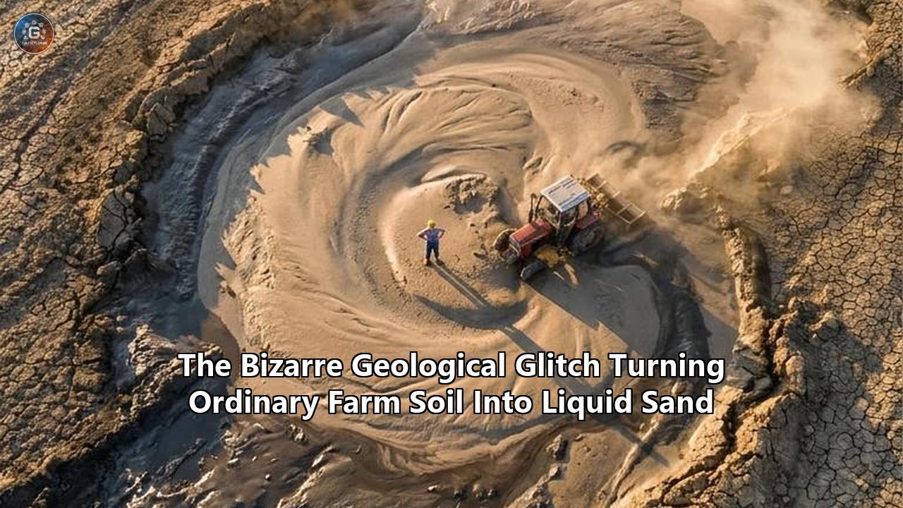
On a Tuesday morning in early May 2026, a 14-ton John Deere tractor operating in Oregon’s Willamette Valley simply vanished into the earth. The farmer had been navigating a perfectly flat, seemingly dry field when the topsoil suddenly lost all bearing capacity. Within minutes, the heavy machinery was swallowed up to its axles, then its cab, sinking into a slurry of liquid sand. No massive earthquake had struck the region. The weather was clear. Yet, the ground beneath the tires had spontaneously transformed from a solid matrix into a viscous fluid.
Across the Pacific Northwest and heavily irrigated regions of the American Midwest, similar reports have flooded agricultural extension offices over the past few weeks. Fields that have supported heavy machinery for generations are experiencing sudden, localized structural failures. Tractors are sinking, irrigation pivots are collapsing, and entire crop lines are being swallowed by sudden surface settling.
Geologists and agricultural engineers are currently wrestling with an unprecedented anomaly: perfectly ordinary farm soil is falling victim to a geological glitch triggered by an alignment of saturated water tables, unique silt profiles, and microscopic seismic waves. This phenomenon is dismantling long-held assumptions about soil mechanics and forcing a rapid reassessment of how modern agriculture interacts with subsurface hydrology.
The Mechanics of the Glitch
To understand how solid ground turns into a liquid trap, one must look closely at the physical forces holding the earth together. A soil mass behaves like a firm solid only when the weight of each individual particle rests securely on the particles directly below it. This grain-to-grain contact creates friction, which provides the soil with its structural integrity and weight-bearing capacity.
In hydrogeology, this concept is governed by Terzaghi’s principle of effective stress. The effective stress is the total stress of the soil pushing down, minus the pore water pressure pushing outward. When the gaps between the soil grains fill entirely with water—reaching 100 percent saturation—the soil is primed for failure. If an external force is applied, the water pressure inside those microscopic pores spikes. Because water is incompressible, this sudden spike in pressure pushes the soil grains apart.
When the pore water pressure equals the total stress, the effective stress drops to zero. The friction between the particles disappears entirely. The soil grains become suspended in the water, and the entire mass behaves like a thick, heavy fluid. When we look at standard models of soil liquefaction explained in undergraduate geology courses, the primary requirement for this dramatic pressure spike is a massive, violent shaking event.
Historically, this catastrophic loss of soil strength was exclusively associated with major seismic disasters. The 1964 Niigata earthquake in Japan famously caused apartment buildings to tilt completely intact as the ground beneath them liquefied. During the 2010–2011 Canterbury earthquakes in New Zealand, widespread liquefaction forced thousands of tons of wet silt to the surface, destroying residential infrastructure. More recently, the magnitude 6.8 earthquake that struck the Sarangani Peninsula in the Philippines in late 2023 triggered massive lateral spreads and sediment venting along the lowlands.
In all of these historical cases, the trigger was obvious: violent, high-energy shaking that violently compacted the saturated soil. But the events occurring in agricultural basins in 2026 feature almost zero noticeable seismic activity. The triggers are functionally invisible.
The Low-Energy Seismic Mystery
The key to unlocking this modern agricultural glitch lies in recent breakthroughs regarding how seismic energy interacts with waterlogged ground. For decades, the scientific consensus held that soil liquefaction was a predominantly "undrained" process occurring near an earthquake's epicenter under high-energy density conditions. It was believed that the soil had to be shaken so violently and so quickly that the water trapped inside had absolutely no time to escape, forcing the pressure to build instantly.
However, geophysicists have recently completely rewritten this assumption. Research led by Dr. Shahar Ben-Zeev at The Hebrew University of Jerusalem and the University of Strasbourg, alongside experts at Ben-Gurion University, proved that liquefaction can easily occur under drained conditions and at remarkably low seismic-energy density levels.
Their data demonstrated that low-frequency seismic waves—often generated by distant, minor tremors that humans cannot even feel—can facilitate interstitial fluid flow within the soil. If a localized area is highly saturated, these gentle, distant waves can cause a slow but steady accumulation of excess pore pressure gradients. Instead of a violent, immediate collapse, the soil undergoes a rapid propagation of a "compaction front". The energy injection rate is low, but it is steady enough to eventually push the pore pressure past the critical threshold.
In the Willamette Valley anomaly, localized sensors detected a minor offshore tremor—a magnitude 4.2 disturbance hundreds of miles away—just prior to the soil failure. To a human standing in the field, the ground was perfectly still. To the deeply saturated, heavily tilled soil matrix, the microscopic vibrations acted as a slow-motion trigger, unlatching the friction between millions of grains of sand and silt until the tractor's weight caused a complete structural punch-through.
The Silt Factor: Why Farms Are Vulnerable
The sudden vulnerability of farmland is not merely a consequence of distant tremors; it is a direct result of the soil's engineered composition. Modern agricultural soils are highly managed environments. Decades of deep tilling, crop rotation, and the mechanical breakdown of clods have created a highly uniform topsoil layer. More critically, agricultural basins are typically located in ancient floodplains, river valleys, and deltas, which are naturally rich in a specific combination of sand and silt.
The European Union’s LIQUEFCTN SILTYSANDS project specifically investigated the role of these tiny, silt-sized grains in soil stability. Geotechnical engineers traditionally focused on pure sand when modeling liquefaction. However, the EU researchers discovered that the availability of fine silt grains (smaller than 0.0075 millimeters) suspended within a dominant sand matrix drastically alters the liquefaction potential.
Silt acts as a micro-lubricant and a pore-blocker. When water attempts to drain out of the soil during a low-level seismic event, the microscopic silt particles clog the drainage pathways. This turns a theoretically "drained" soil profile into a highly pressurized trap. Furthermore, the angularity and specific gradation of agricultural silt—often altered by years of chemical fertilization and mechanical crushing—create a matrix that is uniquely susceptible to losing its stiffness under sudden stress.
When a heavy piece of machinery, such as a combine harvester or a high-horsepower tractor, rolls over this primed matrix, the dynamic load of the massive tires provides the final spike in pressure. The silt-sand mixture violently reorganizes, the water takes the load, and the machinery sinks. To fully grasp why this is happening to agricultural land, one must look at soil liquefaction explained at the microscopic level: it is not just the water or the shaking, but the specific, highly refined geometry of farm dirt that creates the hazard.
Climate Volatility and the Saturation Catalyst
The final ingredient turning stable farmland into liquid sand is the shifting nature of the global water cycle. The years leading up to 2026 have been defined by extreme climate whiplash. Regions like California’s Central Valley and the Pacific Northwest have oscillated between severe multi-year droughts and sudden, violent atmospheric rivers.
This volatility physically changes the soil architecture. Prolonged drought bakes the upper layers of the soil, causing them to shrink, crack, and form a dense, hydrophobic crust. When an atmospheric river subsequently dumps massive volumes of water onto this landscape, the water percolates down through the cracks but is then trapped below the surface by compacted hardpans—dense layers of soil created by years of heavy farm equipment traffic.
The result is a perched water table. The top few inches of the field might appear dry and solid to a farmer walking the crop lines, but just below the surface, a hyper-saturated layer of silty sand is trapped between the dry crust above and the impermeable hardpan below. This hidden layer is continuously held at 100 percent saturation. It is effectively a pressurized water balloon buried inches beneath the tires of million-dollar agricultural equipment. When the microscopic seismic waves from a distant offshore fault line ripple through this perched water table, the trapped water has nowhere to go, resulting in an immediate drop in effective stress.
Microbial Desaturation: Engineering a Biological Fix
With vast swaths of fertile land suddenly categorized as high-risk liquefaction zones, engineers are rushing to deploy countermeasures. Traditional ground improvement techniques, such as deep dynamic compaction or driving structural piles into the bedrock, are financially and physically impossible for tens of thousands of acres of active cropland. The solution must be cheap, minimally invasive, and capable of operating entirely underground without disturbing the crop cycles.
Researchers at Portland State University (PSU) have spearheaded a biological approach that targets the core physical requirement of liquefaction: water saturation. “The idea is that for the soils to liquefy, you need to have 100% saturation,” explained PSU engineer Arash Khosravifar. “This method works by reducing that saturation ratio from 100% down to whatever level required for it not to be liquefiable”.
The technique is known as microbially induced desaturation. It relies on injecting specific strains of naturally occurring denitrifying bacteria into the vulnerable soil layers, along with a nutrient solution typically containing nitrate and a carbon source like acetate.
Inside a heavily instrumented seepage tank at PSU—a testing environment affectionately dubbed the "magic tent" by Ph.D. student Fadzai Zivanai—researchers have mapped exactly how these microbes alter the hydrogeology. As the bacteria consume the provided nutrients, a metabolic byproduct of their digestion is nitrogen gas. The microbes effectively "burp" microscopic gas bubbles directly into the pore spaces between the sand and silt particles.
These biogenic gas bubbles displace the water. Because the gas is highly compressible (unlike water), it acts as a microscopic shock absorber. If a distant seismic wave ripples through the soil, or if a massive tractor drives overhead, the pressure is absorbed by the compression of the nitrogen bubbles rather than forcing the soil grains apart.
“For the first time, I believe in the U.S., we applied this method in the field with the field conditions to see if it works,” Khosravifar noted regarding their recent deployment near Portland’s industrial hubs and adjacent vulnerable soil zones. The field tests have shown real promise. Because the bubbles are trapped within the complex geometry of the silty sand matrix, the desaturation effect can last for years, continuously defending the soil against the liquid sand glitch without requiring any mechanical intervention.
The Financial Sinkhole: Agricultural Economics Under Pressure
The sudden emergence of low-energy liquefaction is sending shockwaves through the agricultural economy. The immediate physical damage is staggering. A modern Class 9 combine harvester weighs up to 25 tons and carries a price tag easily exceeding $750,000. When a machine of this scale sinks to its chassis in liquid sand, recovery is a logistical nightmare.
Standard tow trucks cannot enter the liquified field without sinking themselves. Recovery requires specialized crane matting, tracked heavy-lift excavators, and sometimes days of careful extraction. The physical extraction process aggressively churns and compacts the surrounding soil, destroying the delicate organic structure and rendering that specific patch of land barren for multiple growing seasons.
Beyond equipment damage, there is the direct loss of the crops. When the ground liquefies and undergoes "lateral spreading"—where the surface soil slides sideways over the liquefied subsurface layer—the root systems of row crops are violently sheared in half. Orchards are particularly devastated; mature fruit and nut trees, which take decades to establish, will instantly tilt, uproot, or sink when the bearing capacity of the soil drops to zero.
The sudden influx of claims has left agricultural actuaries scrambling for a new paradigm of soil liquefaction explained through the lens of climate-induced saturation rather than pure seismology. Traditional crop insurance and farm equipment policies often carry specific exclusions for "earth movement" or seismic events. However, because these new agricultural sinkholes are occurring without a federally declared earthquake disaster, farmers and insurers are locked in complex legal battles over whether the sudden liquefaction constitutes a weather-related water event or an excluded geological failure.
Land valuation is also taking a direct hit. Agricultural real estate is priced on a combination of water rights, soil fertility, and historical yield. As geotechnical hazard maps are redrawn to include low-energy drained liquefaction zones, prime acreage situated in ancient, silty floodplains is seeing a sudden risk premium attached to its financing. Lenders are demanding geological surveys before underwriting loans for new irrigation infrastructure or heavy machinery purchases, adding a new layer of friction to farm operations.
Predictive Mapping: Algorithms in the Mud
To prevent farmers from blindly driving half-million-dollar machines into hidden liquid sand traps, geologists are integrating massive datasets into predictive machine learning models. If the exact parameters that trigger the glitch are known—specific soil organic carbon levels, silt-to-sand ratios, perched water table depths, and real-time micro-seismicity—algorithms can map the vulnerability of a field before a tractor ever touches it.
Researchers analyzing complex soil matrices, such as those studying soil organic carbon dynamics in hyperarid oases of the Eastern Tarim Basin, have demonstrated the sheer power of interpretable machine learning in hydrogeology. By feeding pedogenic properties (soil texture, cation exchange capacity, salinity) and topographical data into Random Forest algorithms, geologists can isolate the non-linear interactions that make a specific hectare of land vulnerable to sudden failure.
In the American Midwest and the Pacific Northwest, these same machine learning frameworks are being adapted to predict liquefaction. Drones equipped with ground-penetrating radar and multispectral sensors fly over the fields shortly after heavy rains. They map the subsurface moisture pooling and identify the exact depth of the dense hardpan layers. This data is cross-referenced with regional USGS seismometers that track low-frequency waves from distant fault lines.
The output is a dynamic, daily hazard map delivered directly to a farmer's tablet. Areas shaded in red indicate zones where the saturation ratio has reached the critical 100 percent threshold and the silt matrix is primed for structural collapse. Farmers can then route their heavy equipment around these zones or delay harvesting until the natural drainage reduces the pore water pressure. This application of AI is transforming geotechnical risk assessment from a static, decade-long mapping process into a real-time agricultural weather report.
Redrawing the Geotechnical Map
The realization that ordinary farm soil can suddenly behave like a fluid without a catastrophic earthquake is forcing a systemic overhaul of civil and agricultural engineering. The built environment has long relied on empirical equations and historical data to determine safe bearing capacities. But as climate volatility alters the saturation baselines of our soils, the historical data is no longer a reliable predictor of future stability.
Several major milestones are on the immediate horizon for the agricultural sector. First, the widespread commercialization of microbial desaturation treatments is expected to accelerate. What began in the "magic tents" of university engineering departments will soon scale up to commercial crop-dusting or targeted fertigation systems, allowing farmers to proactively "burp" their fields ahead of heavy planting seasons.
Second, the design of agricultural machinery is undergoing rapid iteration. Equipment manufacturers are experimenting with ultra-low ground pressure (ULGP) track systems and autonomous, lightweight swarming tractors. Instead of sending a single 25-ton machine to harvest a field—concentrating massive dynamic load on a single point and triggering the localized pressure spike needed for liquefaction—farmers will increasingly deploy fleets of automated, two-ton rovers that distribute the weight safely across the soil matrix.
Ultimately, the mechanics of soil liquefaction explained by recent low-energy seismic models serve as a stark warning about the interconnected nature of earth systems. The ground beneath our feet is not a static, inert platform. It is a highly sensitive, dynamic matrix of minerals, water, and biological material. By pushing agricultural soils to their absolute physical limits through intense mechanical tilling and dramatically altering regional hydrology, we have inadvertently tuned the earth to a specific, delicate frequency. As the climate continues to deliver extreme swings in moisture, understanding and mitigating this bizarre geological glitch will become a foundational requirement for securing the global food supply.
Reference:
- https://www.nationalacademies.org/news/can-earthquakes-liquefy-soil
- https://www.mdpi.com/2624-795X/6/4/80
- https://www.preventionweb.net/news/research-reveals-new-insights-soil-liquefaction-during-earthquakes
- https://en.huji.ac.il/news/research-reveals-new-insights-soil-liquefaction-during-earthquakes
- https://cordis.europa.eu/article/id/174955-influence-of-silt-on-soil-liquefaction
- https://www.international-agrophysics.org/Interpretable-machine-learning-unravels-hierarchical-controls-on-soil-organic-carbon,206078,0,2.html