Beneath the vast, frozen expanse of Antarctica lies a hidden world of immense scale and profound importance – a complex network of deep underwater canyons, recently revealed in unprecedented detail. This labyrinth of submarine valleys, carved into the continental shelf and slope, plays a critical, and until now, largely unappreciated role in shaping our planet's climate, ocean circulation, and marine biodiversity. The recent mapping of this vast underwater network has opened a new chapter in our understanding of the frozen continent and its global influence.
Unveiling the Hidden Grand Canyons of the Antarctic
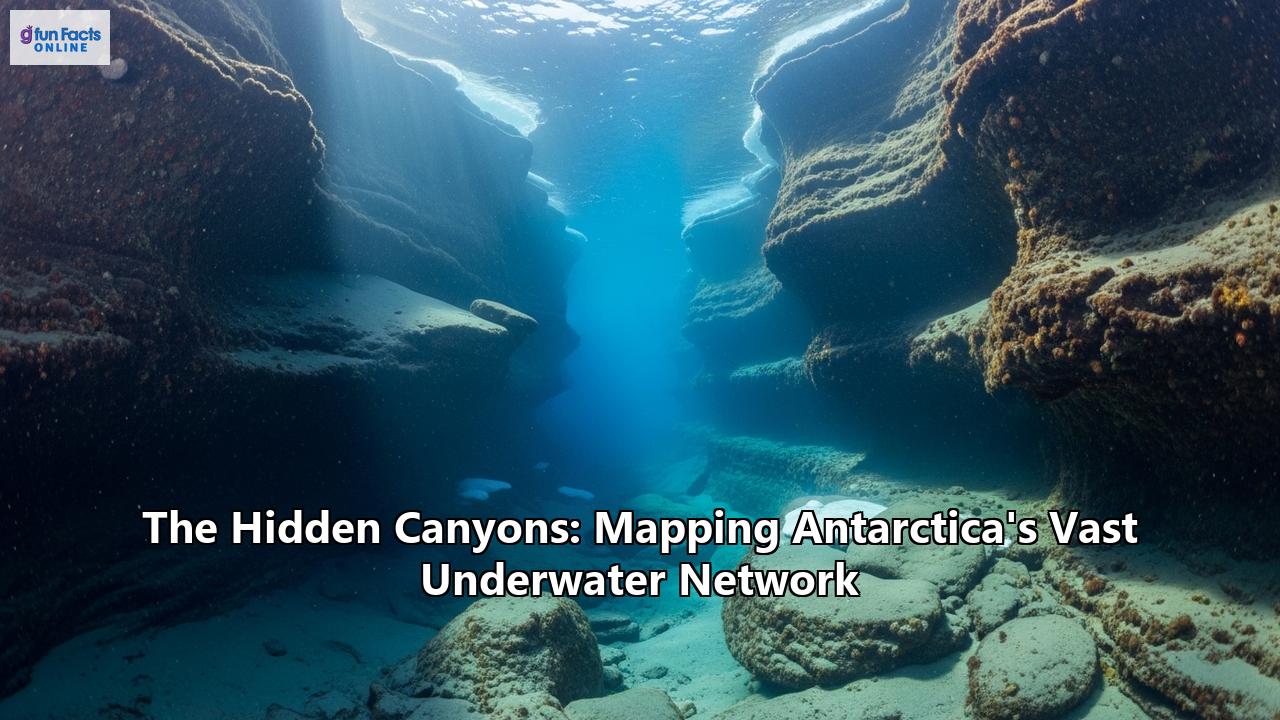
In a significant leap for polar science, researchers have recently cataloged a staggering 332 submarine canyon networks crisscrossing the seafloor around Antarctica. This monumental undertaking, which has increased the number of known Antarctic canyons by a factor of five, has unveiled a breathtaking underwater landscape, with some canyons plunging to depths of over 4,000 meters, deeper than the Grand Canyon.
This groundbreaking discovery was made possible through the analysis of high-resolution bathymetric data from the International Bathymetric Chart of the Southern Ocean (IBCSO) v2. This detailed mapping of the seafloor, with a resolution of 500 meters per pixel, allowed scientists from the University of Barcelona and University College Cork to employ semi-automated techniques to identify and analyze these colossal features with greater accuracy than ever before. The result is a comprehensive inventory that sheds light on the geomorphometry of these canyons, revealing crucial details about their structure and formation.
The Architects of the Abyss: Forged by Ice and Gravity
The formation of Antarctica's submarine canyons is a story of immense geological forces acting over vast timescales. The primary architects of these underwater chasms are the relentless power of glaciers and the erosive force of turbidity currents.
For millennia, the colossal Antarctic ice sheets have ground their way towards the coast, gouging the bedrock and transporting enormous volumes of sediment to the continental shelf. This prolonged glacial action is a key reason why Antarctic canyons are generally larger and deeper than their counterparts in other parts of the world.
The steep slopes of the Antarctic submarine terrain, combined with this abundance of glacial sediment, create the perfect conditions for the formation of turbidity currents. These are essentially underwater avalanches of sediment-laden water that race down the continental slope at high speeds, carving and sculpting the seafloor into the intricate canyon systems we are now able to see. These powerful currents act as the primary erosional force, deepening and widening the canyons over geological time.
The mapping has also revealed a fascinating tale of two Antarcticas, with distinct differences in the canyon systems of the East and West. The canyons in East Antarctica are described as more complex and branching, often with U-shaped cross-sections, suggesting a prolonged period of development under sustained glacial activity. This points to the East Antarctic Ice Sheet having an earlier origin and a more protracted history of shaping the seafloor. In contrast, the canyons in West Antarctica are typically shorter, steeper, and have V-shaped cross-sections. This morphological distinction provides valuable clues about the continent's ancient ice history and the different geological and glacial processes at play in the two regions. The tectonic history of Antarctica, with the West Antarctic Rift System dividing the continent, has also played a role in predisposing the topography to these formations.
Oases of Life in the Frigid Depths
Far from being desolate trenches, Antarctica's submarine canyons are now understood to be vibrant hubs of marine life, acting as critical conduits for nutrients and creating unique habitats that support a rich biodiversity. They serve as funnels, transporting sediments and essential nutrients from the shallow coastal areas to the deep sea, effectively linking different layers of the ocean.
This nutrient transport helps to create biodiversity hotspots on the seafloor. The complex topography of the canyons, with their steep walls and varied substrates, provides a diverse range of niches for benthic communities, which are the organisms that live on the seabed. These communities include a weird and wonderful array of creatures such as crustaceans, worms, echinoderms, and molluscs.
Studies in areas like the Ross Sea, one of the most pristine and productive marine ecosystems on Earth, have revealed a staggering diversity of life. Its icy waters are home to numerous species of whales, penguins, and seals, as well as rich benthic ecosystems with dense cold-water corals. The Ross Sea is a living laboratory, with its canyons playing a vital role in supporting this abundance of life. The region supports a significant portion of the world's Adélie and emperor penguins, as well as Ross Sea orcas and South Pacific Weddell seals.
Similarly, the Weddell Sea is another area rich in wildlife, with colossal swarms of krill forming the base of a food web that includes seals, penguins, and large baleen whales like humpback and minke whales.
Research in specific canyons, such as the Palmer Deep canyon on the western Antarctic Peninsula, has shown that these areas can act as "biomass supermarkets." Ocean currents can transport large amounts of phytoplankton, the foundation of the marine food web, into the canyons, making them attractive feeding grounds for krill and, in turn, for larger predators like penguins. In some cases, the unique conditions within the canyons can also foster local phytoplankton blooms, creating a "farm-like" environment that further enhances biological productivity. There is also evidence of chemosynthetic ecosystems in the Antarctic, which derive energy from chemical reactions rather than sunlight, further highlighting the potential for unique life forms in these extreme environments.
The Canyons' Crucial Role in Global Climate
The discovery and detailed mapping of Antarctica's underwater canyon network have profound implications for our understanding of global climate change. These submarine valleys act as critical conduits for ocean currents, influencing both the formation of deep ocean water and the melting of the Antarctic ice sheets.
The canyons play a pivotal role in the global ocean conveyor belt by channeling cold, dense water formed near the ice shelves into the deep ocean. This process contributes to the formation of Antarctic Bottom Water (AABW), a key component of global ocean circulation that helps to regulate the planet's climate by distributing heat.
Of more immediate concern is the role of the canyons in channeling warmer ocean waters towards the Antarctic coastline. Warm, salty Circumpolar Deep Water (CDW) can flow through these underwater highways, reaching the base of floating ice shelves and melting them from below. This basal melting can thin the ice shelves, which act as buttresses for the glaciers behind them. The weakening or collapse of these ice shelves can lead to an acceleration of glacial flow into the ocean, directly contributing to global sea-level rise.
The new, high-resolution bathymetric data is crucial for improving the accuracy of climate models. Current climate models, including those used by the Intergovernmental Panel on Climate Change (IPCC), often lack the detail to accurately simulate the complex interactions between ocean currents and the intricate topography of the seafloor at a local scale. By incorporating the precise location and morphology of these canyons, scientists can create more reliable models of ocean circulation and ice-sheet dynamics, leading to more accurate projections of future climate change impacts, particularly in vulnerable polar regions. This improved understanding will allow for better predictions of the flux of warm water towards the ice shelves and its potential impact on sea-level rise.
The Future of Antarctic Exploration
The mapping of this vast canyon network is a monumental achievement, yet it also highlights how much of the Antarctic seafloor remains unexplored. Only about 27% of the world's seafloor has been mapped in high resolution, and the polar regions remain one of the last great frontiers of discovery on our planet.
The future of Antarctic research will rely on a new generation of research vessels and autonomous underwater vehicles (AUVs). The development of new polar research vessels, such as the RRS Sir David Attenborough and the planned Antarctic Research Vessel (ARV) from the U.S. National Science Foundation, will provide scientists with state-of-the-art platforms for exploring these remote and challenging environments. These ships are equipped with advanced multibeam echosounders for high-resolution seafloor mapping and can deploy a range of robotic vehicles.
AUVs, or robot submarines, are becoming increasingly vital for exploring areas that are too dangerous or inaccessible for ships, such as beneath thick ice shelves. These untethered vehicles can be pre-programmed to survey vast areas of the seafloor, collecting a wealth of data on bathymetry, ocean properties, and even marine life.
The ongoing exploration of Antarctica's hidden canyons is not just about filling in the blank spaces on our maps. It is about gaining a deeper understanding of the complex processes that govern our planet's climate and the rich tapestry of life that exists in its most extreme environments. As we continue to unveil the secrets of this vast underwater network, we are not only mapping the hidden canyons of Antarctica but also charting a course towards a more complete understanding of our world and its future.
Reference:
- https://shiawaves.com/english/news/world/environment/130143-scientists-map-antarctic-canyons-to-better-predict-climate-impacts/
- https://scitechdaily.com/332-hidden-canyons-discovered-under-antarctica-and-they-could-be-accelerating-climate-change/
- https://www.sci.news/othersciences/geoscience/antarctic-submarine-canyons-14082.html
- https://www.theguardian.com/environment/2025/jul/31/scientists-map-antarctic-seafloor-canyons-to-help-predict-climate-change
- https://www.youtube.com/watch?v=t7wtMB4THww
- https://www.discovermagazine.com/new-map-reveals-antarcticas-gigantic-submarine-canyons-some-deeper-than-13-47838
- http://www.sciencedaily.com/releases/2025/08/250809100910.htm
- https://www.youtube.com/watch?v=C2km0TIta2Y
- https://pmc.ncbi.nlm.nih.gov/articles/PMC2981985/
- https://www.researchgate.net/publication/347400151_Role_of_dense_shelf_water_in_the_development_of_Antarctic_submarine_canyon_morphology
- https://eos.org/research-spotlights/where-do-antarctic-submarine-canyons-get-their-marine-life
- https://www.earth.com/news/antarctica-is-hiding-hundreds-of-massive-underwater-canyons/
- https://www.theinertia.com/environment/scientists-detailed-antarctic-canyons-map/
- https://thedebrief.org/scientists-reveal-most-detailed-map-of-antarcticas-seafloor-canyons-ever-made/