Beneath our feet, the Earth is alive. It breathes, it shifts, and occasionally, it unleashes raw, unbridled fury. Throughout human history, volcanic eruptions have been viewed as unpredictable acts of nature—sudden cataclysms capable of burying cities, choking the skies, and altering the global climate. For centuries, the only way to understand these fiery giants was to stand at their feet, a dangerous and often fatal endeavor for the scientists who dared to listen to the rumblings of the abyss.
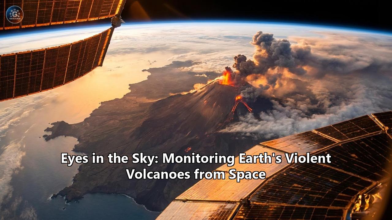
Today, however, the paradigm has shifted. Humanity has retreated from the crater's edge and looked upward. Orbiting hundreds of miles above our heads, a sophisticated armada of satellites maintains a silent, unblinking vigil over the estimated 1,500 active volcanoes scattered across our planet. From the desolate ice fields of Iceland to the dense, cloud-shrouded jungles of Indonesia, these "eyes in the sky" have revolutionized volcanology. By leveraging a spectrum of advanced technologies—ranging from synthetic aperture radar that measures microscopic bulges in the Earth's crust to ultraviolet sensors that sniff out invisible toxic gases—scientists can now predict, track, and mitigate volcanic disasters with unprecedented precision.
This is the story of how space technology has become our most vital shield against the fiery wrath of the inner Earth, transforming volcanology from an observational science into a predictive, life-saving discipline.
The Challenges of Terrestrial Volcanology
To truly appreciate the marvel of satellite monitoring, one must first understand the sheer logistical nightmare of monitoring a volcano from the ground. Earth’s volcanic hotspots are often located in some of the most remote and inhospitable environments imaginable. Consider the Aleutian Islands in Alaska, where volcanoes routinely blanket the North Pacific in ash, or the deep, inaccessible rainforests of the Democratic Republic of the Congo, home to the hyperactive Mount Nyiragongo.
Deploying traditional monitoring equipment—such as seismometers to detect earthquakes, GPS stations to measure ground movement, and gas analyzers to check for sulfur dioxide—requires flying scientists and delicate gear into these hostile terrains. Once installed, these instruments must survive corrosive acid rain, hurricane-force winds, suffocating ashfalls, and extreme temperature fluctuations. Often, equipment is simply destroyed by the very mountain it is meant to observe. Furthermore, many developing nations simply lack the financial resources to maintain expensive ground networks across all their active peaks.
This is where satellites bridge the gap. Satellites do not melt in lava flows. They do not succumb to toxic volcanic gases. Orbiting in the cold vacuum of space, they provide a globally consistent, uniform, and safe method for monitoring the restless Earth. Every day, they beam down terabytes of data, allowing a scientist sitting in an office in London or Washington to track magma rising beneath a mountain in Papua New Guinea in near real-time.
The Satellite Arsenal: How We Look at Volcanoes from Space
Satellites do not merely "take pictures" of volcanoes. They observe the Earth across the entire electromagnetic spectrum, capturing data that is entirely invisible to the naked human eye. This orbital arsenal is broadly categorized into four main observational techniques: thermal imaging, radar interferometry, ultraviolet spectrometry, and high-resolution optical observation.
1. Thermal Imaging: Seeing the Heat
Before magma ever breaches the surface, it makes its presence known through heat. As a magma body ascends through the Earth's crust, it warms the surrounding rock and groundwater, often causing an increase in the temperature of fumaroles (gas vents), crater lakes, and the ground itself.
Satellites equipped with thermal infrared sensors, such as the Moderate Resolution Imaging Spectroradiometer (MODIS) aboard NASA’s Terra and Aqua satellites, and the Visible Infrared Imaging Radiometer Suite (VIIRS) on the Suomi NPP and NOAA-20 satellites, are uniquely designed to detect these thermal anomalies. These instruments act as cosmic thermometers. They scan the globe multiple times a day, searching for microscopic spikes in heat radiation.
One of the most remarkable tools born from this technology is the MIROVA (Middle Infrared Observation of Volcanic Activity) system. Developed by Italian researchers, MIROVA constantly analyzes MODIS and VIIRS data to detect volcanic hotspots globally. When a volcano’s thermal output begins to climb above its normal baseline, it is often the first whisper of an impending eruption. More recently, high-spatial-resolution satellites like the European Space Agency’s Sentinel-2 and NASA’s Landsat 8 and 9 have been integrated into these systems. While MODIS might see a general blur of heat over a volcano (at a 1-kilometer resolution), Sentinel-2 can pinpoint the exact vent where the heat is emanating with a resolution of 20 meters, allowing scientists to tell if a lava lake is rising or if a new fissure is opening.
2. Radar Interferometry (InSAR): Measuring the Magma Heartbeat
Perhaps the most magical and counter-intuitive technology in the space-based volcanology toolkit is InSAR (Interferometric Synthetic Aperture Radar). To understand InSAR, you have to imagine a volcano like a balloon. When magma rushes into a subterranean chamber, the pressure increases, and the mountain physically swells—a process known as inflation. When the volcano erupts or the magma drains away, the mountain deflates.
In the past, measuring this inflation required physically hiking up a volcano and placing GPS markers. Today, we use radar satellites, most notably the European Copernicus program's Sentinel-1 constellation. Unlike optical cameras, radar satellites emit their own energy—microwave pulses—that travel down to Earth, bounce off the ground, and return to the satellite. Because these microwaves penetrate clouds, rain, and total darkness, Sentinel-1 can operate 24 hours a day, regardless of the weather.
When a satellite passes over a volcano, it maps the precise distance to the ground. When it passes over the exact same spot a few days or weeks later, it maps the distance again. By combining (interfering) these two radar images, computers can generate a rainbow-colored map called an "interferogram." These stunning, psychedelic-looking maps show exactly how much the ground has deformed, down to the millimeter.
If a vibrant series of concentric rings appears on an interferogram, resembling a bullseye over a volcano, it means the ground is bulging upward. It is the literal heartbeat of the mountain, indicating that magma is pooling just beneath the surface. InSAR has revolutionized our ability to forecast eruptions by revealing the hidden plumbing systems of the Earth.
3. Ultraviolet Sensors: Sniffing the Toxic Plumes
When magma rises, the decrease in pressure causes dissolved gases to bubble out—much like opening a shaken bottle of soda. The most prominent of these gases is water vapor, but the second most common, and by far the most diagnostic, is Sulfur Dioxide (SO2). Because SO2 is highly reactive and has a relatively short lifespan in the lower atmosphere, a sudden spike in SO2 emissions is a smoking gun that fresh magma is very close to the surface.
To track this, we rely on ultraviolet (UV) spectrometers. Instruments like the Ozone Monitoring Instrument (OMI) on NASA’s Aura satellite and, more recently, the incredibly powerful TROPOMI (TROPOspheric Monitoring Instrument) on the Sentinel-5 Precursor satellite, specialize in detecting trace gases in the atmosphere.
TROPOMI measures the sunlight scattering off the Earth’s atmosphere back into space. Because SO2 absorbs specific wavelengths of ultraviolet light, the satellite can look at the "missing" wavelengths and calculate exactly how much sulfur dioxide is present. By "sniffing" the air from space, scientists can calculate the volume of gas a volcano is exhaling. If a volcano is visibly deflating but its gas emissions are skyrocketing, it tells scientists that a highly explosive, gas-rich eruption is highly likely. Furthermore, tracking massive SO2 clouds as they drift across the globe is critical for climate modelers, as sulfur aerosols reflect incoming sunlight and can temporarily cool the planet.
4. Optical and Geostationary Satellites: Watching the Sky Unfold
When a major eruption finally happens, the immediate threat is often the massive plume of pulverized rock, glass, and gas—known as volcanic ash—that rockets into the atmosphere. For this, we rely on geostationary weather satellites like the American GOES-R series (GOES-16 and 18), the European Meteosat, and the Japanese Himawari.
Unlike polar-orbiting satellites (like Sentinel and Landsat) which fly low and capture high-resolution images of specific swaths of the Earth every few days, geostationary satellites orbit at a staggering 35,000 kilometers above the equator. From this vantage point, they stare at the exact same hemisphere of the Earth continuously, taking full-disk images every few minutes.
When a volcano explodes, GOES and Himawari capture the eruption in near real-time. They track the ash cloud's trajectory, allowing meteorologists to issue rapid warnings. These satellites utilize multiple infrared bands to differentiate volcanic ash from ordinary meteorological water clouds—a process known as the "split-window" technique. Because silicate ash absorbs and radiates heat differently than water vapor, scientists can isolate the ash cloud, calculate its altitude, and predict where the winds will carry it.
Case Studies in Orbital Vigilance
To understand the sheer power of this satellite armada, we must examine how these orbital sentinels have performed during some of the most dramatic volcanic crises of the 21st century.
The Hunga Tonga-Hunga Ha'apai Cataclysm (2022)
On January 15, 2022, an underwater volcano in the Kingdom of Tonga known as Hunga Tonga-Hunga Ha'apai detonated with a ferocity the world had not seen since the eruption of Mount Pinatubo in 1991. The explosion generated a devastating tsunami and severed the only undersea fiber-optic cable connecting Tonga to the rest of the world. In an instant, the island nation was cast into silence.
With ground communications entirely wiped out, satellites became humanity's sole window into the disaster. The Japanese geostationary satellite Himawari-8 and the American GOES-17 satellite captured the most stunning and terrifying orbital footage in the history of earth observation. They recorded a colossal mushroom cloud of ash and water vapor erupting from the ocean, expanding at supersonic speeds. Shockwaves—atmospheric gravity waves—were visibly seen rippling outward from the eruption center, circling the globe multiple times.
Using satellite data, scientists determined that the plume broke global records, piercing the stratosphere and reaching a staggering altitude of 58 kilometers (36 miles) into the mesosphere. NASA’s Aura and Sentinel-5P tracked the resulting sulfur dioxide cloud, while radar satellites mapped the total destruction of the volcanic island itself. Without satellites, the true scale and atmospheric impact of the Tonga eruption would have remained a terrifying mystery. The prompt data from Himawari-8 allowed tsunami warning centers across the Pacific to issue immediate evacuation orders, saving countless lives on distant shores.
The Icelandic Awakening: Reykjanes Peninsula (2021–2024)
For 800 years, the Reykjanes Peninsula in Iceland lay dormant. Then, in early 2021, the earth began to tear itself apart. Intense earthquake swarms rocked the capital city of Reykjavik, signaling that the tectonic plates were shifting and magma was forcing its way up from the mantle.
Iceland boasts one of the most sophisticated ground-monitoring networks in the world, but it was the synergy with satellite data—specifically Sentinel-1 InSAR—that provided the critical breakthrough. As the earthquakes raged, radar interferograms revealed a massive, subterranean "dike" (a vertical sheet of magma) slicing through the crust. The colorful InSAR maps showed the ground on either side of the dike spreading apart and bulging upward by tens of centimeters.
Because scientists could map the exact shape and trajectory of this underground magma river from space, they were able to forecast not just that an eruption would happen, but where the lava would likely break the surface. When the Fagradalsfjall fissure finally erupted in March 2021, it occurred exactly where the satellite data predicted.
This process repeated during the dramatic events of late 2023 and early 2024. As magma accumulated beneath the town of Grindavík and the nearby Svartsengi geothermal power plant, InSAR satellites measured the ground rising at an alarming rate of several millimeters per day. Armed with this orbital intelligence, Icelandic authorities evacuated the town of Grindavík days before massive fissures ripped through the streets and lava consumed several homes. Thermal satellites like Sentinel-2 and Landsat were then used to map the advancing lava flows, updating computer models that helped engineers build massive earthen dams to successfully divert the lava away from the critical power plant.
Protecting the Skies: The Aviation Imperative
If you have ever flown on a commercial airliner, you owe your safety in part to satellite volcanology. Volcanic ash is not like the soft ash from a wood fire; it is composed of jagged, microscopic shards of volcanic glass and pulverized rock. When a jet engine ingests this ash, the extreme heat melts the glass, coating the engine's turbines in a thick, sticky glaze. The engines choke, stall, and fail entirely.
The most infamous incident occurred in 1982 when British Airways Flight 9 flew through the ash cloud of Mount Galunggung in Indonesia. All four engines failed, causing the Boeing 747 to glide silently toward the ocean before the engines miraculously restarted at a lower altitude.
To prevent this from ever happening again, a global network of nine Volcanic Ash Advisory Centers (VAACs) was established. These centers rely almost entirely on satellite data to keep the skies safe. During the 2010 eruption of Eyjafjallajökull in Iceland, which grounded European aviation for a week and cost the global economy billions, satellites were the primary tool used to track the invisible ash clouds drifting over the continent. Today, algorithms continually analyze data from GOES, Meteosat, and Himawari. If a satellite detects a sudden thermal spike combined with an expanding ash plume, it automatically triggers an alert to the VAAC, which then reroutes commercial flights safely away from the danger zone. Space-based monitoring ensures that thousands of flights safely navigate around the dozens of volcanoes erupting on any given day.
The Big Data and AI Revolution
We are currently living in a golden age of Earth observation. Satellites are launching at an unprecedented rate, creating a new and formidable challenge: we have too much data. A single Sentinel satellite beams down terabytes of radar imagery a day. With 1,500 active volcanoes, it is physically impossible for human scientists to manually process, inspect, and analyze every interferogram, thermal image, and gas reading.
To solve the "data deluge," volcanology is undergoing an artificial intelligence revolution. Machine learning algorithms are now being trained to act as automated watchdogs. Projects like the COMET (Centre for the Observation and Modelling of Earthquakes, Volcanics and Tectonics) database automatically ingest Sentinel-1 radar data and use machine learning to scan for deformation. The AI looks for the telltale concentric rings of ground inflation. If the algorithm spots a volcano bulging, it flags it and sends an alert to human researchers.
Similarly, computer vision models are being trained on decades of thermal satellite imagery. These neural networks can instantly distinguish between a false positive (like a forest fire or a highly reflective cloud) and a true volcanic thermal anomaly. By combining these diverse satellite datasets—matching a spike in SO2 from TROPOMI, ground inflation from Sentinel-1, and thermal anomalies from MODIS—AI systems are beginning to develop complex predictive models. In the near future, an AI analyzing satellite feeds could automatically issue an eruption probability forecast days or even weeks before the first rock is thrown.
The Future of Orbital Volcanology
As we look toward the horizon, the capabilities of satellite volcanology are poised to expand dramatically. The next great leap forward is the upcoming NISAR (NASA-ISRO Synthetic Aperture Radar) mission. Jointly developed by the United States and India, NISAR is set to revolutionize InSAR technology. Current radar satellites primarily use C-band radar, which has a relatively short wavelength. While excellent for bare rock (like in Iceland or the Andes), C-band radar struggles to penetrate dense vegetation. When it hits the thick jungle canopies of Indonesia, the Philippines, or Central America, the radar signal scatters, rendering it difficult to measure the ground deforming beneath the trees.
NISAR will employ L-band and S-band radar, which have much longer wavelengths. These radar beams will punch straight through the dense tropical canopies, bounce off the volcanic rock, and return to space. For the first time, we will be able to continuously and accurately measure ground inflation at hundreds of highly dangerous, heavily vegetated volcanoes in the tropics that currently have zero ground monitoring.
In addition to NISAR, the rise of commercial "New Space" companies like Planet Labs has created mega-constellations of hundreds of shoebox-sized satellites (CubeSats). These constellations provide daily, high-resolution optical imagery of the entire globe. If a volcano erupts anywhere on Earth, we no longer have to wait days for a large government satellite to pass over; a commercial satellite will likely photograph it within hours.
We are also entering the era of hyperspectral imaging. Upcoming satellite missions like NASA’s SBG (Surface Biology and Geology) will not just see in a few wide bands of light, but in hundreds of narrow spectral bands. This will allow scientists to actually identify the chemical composition of lava flows and ash plumes from space. By knowing exactly what minerals are erupting, volcanologists can better understand the deep-mantle source of the magma and the specific hazards it poses.
Guardians in Orbit
Volcanoes are the architects of our world. Over billions of years, their outgassings created the atmosphere we breathe and the oceans we sail. But to live alongside them is to exist on the edge of a blade. The forces that build our planet are the same forces that can casually wipe away human civilization in a deluge of fire and ash.
For most of human history, we were blind to the warning signs of the deep Earth. We relied on folklore, superstition, and the frantic observations of those brave enough to stand in the shadow of the smoke.
Space technology changed everything. The silent sentinels orbiting in the freezing void of space—measuring the millimeter-scale heartbeat of a bulging mountain, sniffing the chemical breath of an awakening crater, and tracking the heat of rising magma—have given us the gift of foresight. Satellite volcanology transcends borders and economies. It allows a scientist in Europe to warn a village in South America, and an algorithm in a server farm to save a jetliner flying over the Pacific.
As technology advances, bringing higher resolutions, deeper canopy penetrations, and AI-driven predictive models, our safety net will only grow stronger. The unpredictable fury of the Earth may never be fully tamed, but through human ingenuity and our unyielding desire to reach for the stars, we have finally found a way to look back down and understand the fire beneath our feet. We no longer wait in the dark for the mountain to speak; we watch, we listen, and we prepare, guided by our unblinking eyes in the sky.
Reference:
- https://www.frontiersin.org/journals/earth-science/articles/10.3389/feart.2018.00240/full
- https://iris.unito.it/bitstream/2318/2016818/2/THESIS_MASSIMETTI.pdf
- https://www.science.gov/topicpages/m/monitoring+volcano+deformation.html
- https://www.science.gov/topicpages/r/radar+insar+technique
- https://www.volcanodiscovery.com/blog/2024-feb/volcanoes-from-space.html
- https://www.quora.com/Is-it-conceivable-that-frequent-volcanoes-now-erupting-worldwide-including-Pacific-Ring-of-Fire-Africa-and-Europe-portend-air-travel-halt
- https://fiveable.me/volcanology/unit-15