To view the Arctic from above in the height of summer is to witness a landscape undergoing a profound and rapid geological metamorphosis. For millennia, the vast, treeless expanses of the circumpolar North—stretching across Alaska, Canada, Siberia, and the Tibetan Plateau—were defined by their solid, unyielding nature. They were bound by permafrost, a subterranean layer of frozen soil, rock, and ice that acted as the steadfast foundation of the tundra. But today, driven by an phenomenon known as Arctic Amplification, temperatures in the high latitudes are rising nearly four times faster than the global average. Under this relentless thermal assault, the foundation is fracturing.
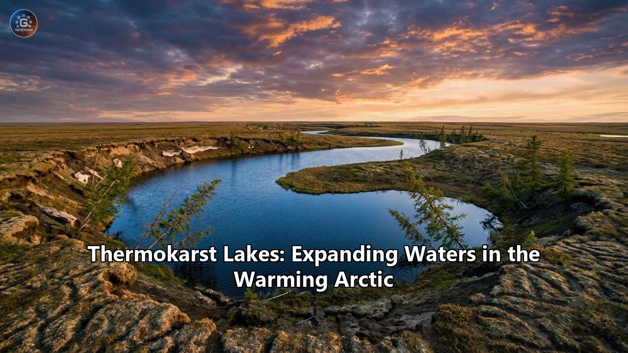
The most striking visual evidence of this collapse is the transformation of the continuous green and white tundra into a porous, pockmarked terrain resembling Swiss cheese. Millions of blue, black, and brown pools of water now dot the landscape. These are thermokarst lakes. Born from the subsidence of thawing, ice-rich earth, these bodies of water are not merely passive reflections of a warming climate; they are active, dynamic biogeochemical reactors that are fundamentally rewiring the Earth’s carbon cycle. As they expand, they consume the surrounding land, awaken dormant microbial life, and release staggering volumes of ancient greenhouse gases into the atmosphere. Yet, their lifecycle is a paradox of rapid expansion and catastrophic, sudden drainage. To understand the future of our global climate, we must look into the dark, bubbling waters of the warming Arctic.
The Architecture of the Cryosphere: Understanding Permafrost
To comprehend the mechanics of a thermokarst lake, one must first understand the frozen architecture upon which it rests. Permafrost is defined as any ground that remains completely frozen—at or below 0°C—for at least two consecutive years. However, much of the permafrost in the Arctic has been frozen for tens of thousands of years, dating back to the Pleistocene epoch.
Permafrost is rarely just frozen dirt. It is a highly complex, ice-rich matrix. Over millennia, repeated cycles of freezing and thawing in the shallow "active layer" (the top layer of soil that thaws each summer) create thermal contraction cracks in the ground. Meltwater seeps into these cracks and freezes, forming vertical wedges of solid ice. Over centuries, these ice wedges can grow to the size of houses. In specific regions, such as the vast unglaciated plains of Siberia and parts of Alaska and Canada, a specialized type of permafrost known as Yedoma exists. Yedoma is extraordinarily rich in organic matter and exceptionally ice-rich, with ice sometimes comprising 50% to 90% of its volume.
Crucially, this frozen ground acts as a planetary freezer. It holds the remains of Pleistocene megafauna, ancient roots, leaves, and untold generations of organic detritus. It is estimated that Arctic permafrost contains roughly 1,500 billion tons of organic carbon—nearly twice the amount of carbon currently residing in the Earth's atmosphere. As long as this carbon remains locked in the deep freeze, it is inert. But when the freezer door is left open, the consequences are global.
The Genesis of a Thermokarst Lake
The birth of a thermokarst lake begins with a thermal disturbance. This can be triggered by a particularly warm summer, the loss of insulating vegetation cover due to a tundra fire, or paradoxically, unusually heavy winter snowfall, which blankets the ground and traps summer heat in the soil, preventing the winter cold from penetrating deeply.
Once the summer heat manages to penetrate deeper than usual, the subterranean ice begins to melt. Because ice occupies more volume than liquid water, its melting creates a void. The ground above, losing its structural support, slumps and collapses—a process known as subsidence. These new topographic depressions collect meltwater and summer rain. At this point, a critical positive feedback loop is initiated.
Water is dark. Unlike the surrounding snow or light-colored tundra vegetation, which has a high albedo and reflects much of the sun's energy back into space, the dark surface of a newly formed pond absorbs solar radiation. The water heats up, turning the pond into a thermal drill. The heat from the water is conducted downward and laterally into the surrounding permafrost, melting more ice wedges and causing further subsidence. The banks of the pond collapse, often visibly eroding in massive, muddy chunks known as retrogressive thaw slumps. The pond widens into a lake.
As the lake deepens, it may eventually cross a critical threshold: it becomes so deep that it no longer freezes completely to the bottom during the bitter Arctic winter. When this happens, a permanent zone of unfrozen, saturated ground forms beneath the lake, known as a talik. The creation of a talik is a point of no return. Thawing conditions on the lake bottom now prevail year-round, uninhibited by the winter freeze. Recent modeling and field studies have shown that beneath some expanding thermokarst lakes, permafrost has thawed as deep as 15 meters within just half a century—a rate of degradation staggering when compared to the mere centimeters of thaw observed in dry tundra soils.
The Biogeochemical Reactor: Waking the Sleeping Giants
Thermokarst lakes are not sterile pools; they are teeming, hyper-active biological hotspots. As the talik expands downward and outward, it encroaches upon the ancient, carbon-rich Yedoma and other permafrost soils. The organic matter—preserved in a suspended state for tens of thousands of years—is suddenly exposed to liquid water and above-freezing temperatures.
This awakens the microbial life that has been lying dormant in the freeze. These microbes immediately begin to feast on the newly available ancient carbon. The metabolic byproduct of this microscopic feast is greenhouse gas, but the type of gas depends entirely on the environment. In the shallow, oxygen-rich margins of the lake, aerobic bacteria break down the carbon and exhale carbon dioxide (CO2). However, at the bottom of a deep thermokarst lake, buried under layers of sediment and water, the environment is strictly anaerobic (devoid of oxygen).
Here, a specific class of microorganisms known as methanogenic archaea takes over. Through anaerobic digestion, they process the ancient carbon and release methane (CH4). This is a critical distinction because methane is a highly potent greenhouse gas, boasting a warming potential approximately 28 to 30 times greater than that of CO2 over a 100-year period.
The transport mechanism of this methane to the atmosphere is perhaps one of the most visually dramatic phenomena in the Arctic. While some methane dissolves into the water column and diffuses slowly from the surface, a vast amount of it is released through a process called ebullition, or bubbling. As gas pressure builds in the lake sediments, it releases violently in discrete, rapid bursts. These bubble plumes rise quickly through the water column, largely bypassing oxidation processes that might otherwise convert the methane to CO2.
During the winter, when the lakes ice over, these bubbles become trapped in the frozen matrix, stacking on top of one another to form spectacular, towering columns of white discs suspended in clear ice. Scientists studying these lakes frequently demonstrate the high methane content of these bubbles by piercing the ice and igniting the escaping gas, creating dramatic flares of fire on the frozen lake surface.
For a long time, standard climate measurements severely underestimated these emissions because they relied on diffusion measurements or short-term chamber deployments that easily missed the episodic, highly localized bursts of ebullition. Recent high-resolution aerial imagery and submerged bubble trap studies have revealed that discrete-seep ebullition can comprise up to 87% of total methane emissions from these lakes. Incorporating these ebullition seeps into terrestrial ecosystem models has increased previous estimates of regional terrestrial methane emissions by up to 5- to 8-fold in regions like Siberia. On the Tibetan Plateau, where permafrost dynamics are also accelerating, ebullition fluxes contribute roughly 66% of the total methane emissions from thermokarst lakes, underscoring the ubiquity of this phenomenon across high-altitude and high-latitude environments.
The Catastrophic Drainage Paradox
If thermokarst lakes are expanding, melting the ground beneath them, and emitting massive amounts of carbon, one might assume the Arctic is destined to become a single, contiguous ocean of shallow water. However, the lifecycle of a thermokarst lake is self-limiting and inherently unstable. While many lakes are expanding, a roughly equal, and sometimes greater, number are rapidly disappearing.
Because these lakes are perched atop a decaying, shifting foundation, their banks are highly vulnerable. As a lake expands laterally through thermo-erosion, its margins may intersect with a topographical gradient, a river channel, or the eroding oceanic coastline. When a breach occurs, the results are explosive.
Catastrophic lake drainage is a hallmark of the warming Arctic. A lake that took decades or centuries to form can vanish in a matter of hours. A prime example occurred on July 5, 2014, in northern Alaska. Lake 195, a sprawling 80-hectare thermokarst lake, suffered a bank failure following abundant winter snowfall and heavy early summer precipitation that elevated its water levels. Bank overtopping led to rapid thermo-erosion along a melting ice-wedge network, carving a 9-meter wide, 2-meter deep drainage gully. The lake emptied an estimated 872,000 cubic meters of water in just 36 hours, producing a peak flood discharge comparable to river basins hundreds of times its size.
This is not an isolated event. As extreme weather events become more common, the rate of lake drainage is accelerating. Following the warmest and wettest winter on record in 2017/2018, northwestern Alaska witnessed an unprecedented mass drainage event. By early summer 2018, 192 lakes had completely or partially drained, exceeding the historical average drainage rate by a factor of ten. The combination of extremely warm mean annual air temperatures (hovering close to 0°C) and excess meltwater promoted rapid lateral breaching.
Furthermore, drainage can occur invisibly from below. If the unfrozen talik beneath a lake deepens enough to penetrate the entire thickness of the permafrost layer, it can connect with sub-permafrost groundwater aquifers. When this internal plug is pulled, the lake drains downward, disappearing into the earth like a bathtub with an open drain.
These competing forces—rapid expansion driven by warming, and catastrophic drainage driven by structural failure—create a highly volatile landscape. In some regions, like the Seward Peninsula in Alaska, lake drainage has outpaced lake growth by nearly 15% over the past few decades, signaling a landscape transitioning away from a lake-rich environment due to advanced permafrost degradation.
Ecological Transformation: The Greening of Drained Basins
When a thermokarst lake drains, it leaves behind a massive, muddy scar on the landscape known as a Drained Lake Basin (DLB). Yet, these scars do not remain barren for long. The drainage of a lake marks the beginning of a rapid and profound ecological succession.
The exposed lakebed is typically rich in organic sediments and nutrients. Almost immediately, opportunistic tundra vegetation, such as sedges, grasses, and eventually woody shrubs, colonize the nutrient-rich basin. Research has shown that vegetation within these drained basins grows significantly faster and more luxuriantly, reaching higher levels of greenness than the undisturbed tundra surrounding them.
This rapid botanical explosion is one of the few natural negative feedback loops in the changing Arctic climate system. The vigorous new plant life acts as a carbon sink, actively drawing down CO2 from the atmosphere through photosynthesis. The thick vegetation also shades the ground, altering the surface albedo once again and potentially helping to restabilize and insulate the underlying permafrost, effectively chilling the ground back down. Over decades, peat can accumulate in these basins, trapping carbon once more.
However, this terrestrial gain is an aquatic loss. The Arctic Coastal Plain and similar environments provide critical summer breeding habitats for millions of migratory waterfowl, shorebirds, and specialized fish species. The sudden disappearance of these lakes drastically reduces the availability of these vital freshwater habitats, forcing species to alter their migration routes and increasing competition in remaining water bodies. The complex terrestrial-aquatic connectivity is severed, forcing a complete realignment of the local food web.
Collapsing Ground, Shifting Lives: The Human and Indigenous Impact
The narrative of thermokarst lakes is frequently told through the lens of chemistry and physics, but it is fundamentally a human story. The Arctic is home to numerous Indigenous communities—including the Inuit, Yupik, Iñupiat, Chukchi, Nenets, and Sakha—whose cultures, livelihoods, and histories are intricately woven into the frozen landscape. For these communities, the destabilization of permafrost is not an abstract climate metric; it is an immediate existential threat.
The traditional knowledge and seasonal rhythms of Indigenous peoples rely on the predictability of the ice and the land. Thermokarst development shatters this predictability. For reindeer herders in the Siberian tundra, the waterlogging of the landscape during the summer forces massive detours in traditional migratory routes. Furthermore, changing precipitation patterns associated with the warming climate lead to deep snow or "rain-on-snow" events, which create impenetrable layers of ice over the tundra, starving reindeer that cannot break through to graze on the underlying lichen.
The impacts on human health and safety are equally alarming. The thawing permafrost is unlocking things that were meant to stay buried. In the summer of 2016, an abnormal heatwave in the Yamal Peninsula thawed a reindeer carcass that had been infected with anthrax decades earlier. The disease, safely suspended in the permafrost for 75 years, was resurrected, leading to a deadly outbreak among local nomadic populations and the culling of thousands of reindeer.
Infrastructure, built under the assumption that the ground would remain perpetually frozen, is failing catastrophically. Roads buckle, pipelines warp and threaten to rupture, and homes sink into the earth. A poignant example is the village of Oymyakon in the Sakha Republic (Yakutia), famous for being one of the coldest permanently inhabited settlements on Earth. Due to historical relocations during the Soviet era, the village was built on highly ice-rich permafrost. Today, as temperatures rise, a massive thermokarst lake is actively forming in the middle of the town. The permafrost beneath the village is developing taliks up to 15 meters deep. Projections suggest the expanding waters will eventually swallow the land where the village currently stands, forcing communities to adapt by constructing boardwalks instead of roads and elevating new structures on specialized, expensive pilings. Collaborative projects integrating Indigenous knowledge with modern engineering are now essential to model sustainable living in these rapidly degrading environments.
Eyes in the Sky and Traps in the Ice: The Science of Observation
Monitoring the erratic behavior of millions of lakes across the vast, inhospitable expanse of the Arctic requires a blend of high-tech remote sensing and grueling field science.
From space, scientists deploy an armada of Earth observation satellites. Optical satellites like Landsat and high-resolution Planet CubeSats continuously photograph the changing surface, while Synthetic Aperture Radar (SAR) from satellites like Sentinel-1 can pierce through cloud cover and even detect whether lake ice is frozen to the bed or floating on liquid water. Researchers employ advanced machine-learning algorithms and change-detection software, such as LandTrendr, to sift through decades of satellite imagery. This hybrid approach allows scientists to pinpoint the exact year, and sometimes the exact week, a lake drained, creating massive spatio-temporal maps of landscape vulnerability.
However, satellites struggle to measure the invisible gases bubbling up from the depths. To quantify the "methane bomb," researchers must venture out onto the ice. Field campaigns often involve deploying submerged bubble traps—essentially inverted funnels placed underwater before the winter freeze—to capture and measure the volume of ebullition seeps year-round. Ground-Penetrating Radar (GPR) and advanced sonar are towed across frozen or liquid lakes to map the depth of the unfrozen taliks hidden beneath the sediment. By combining the macro-scale data of satellite imagery with the micro-scale biogeochemical data collected on the ice, scientists can scale up local methane measurements to estimate the carbon footprint of the entire Arctic.
The Global Climate Ledger: Re-evaluating Earth System Models
The fate of the Arctic is inextricably linked to the global climate system, yet the profound impacts of thermokarst lake formation and drainage remain a blind spot in many global climate forecasts.
Current Earth System Models (ESMs), which are used by bodies like the Intergovernmental Panel on Climate Change (IPCC) to predict future warming and set global carbon budgets, heavily rely on broad, regional generalizations. Because thermokarst lakes form, expand, and drain based on highly localized, small-scale subsurface heterogeneities (like the exact placement of a buried ice wedge), they are incredibly difficult to simulate in massive, grid-based global models. Consequently, the abrupt thaw processes and the massive bursts of methane ebullition associated with thermokarst lakes are often rudimentarily represented, or omitted entirely, from these vital models.
This omission is a critical danger. Studies that have successfully integrated the dynamics of expanding Yedoma thermokarst lakes into specialized ecosystem models reveal a chilling reality. When the rapid, deep thaw of permafrost beneath these lakes is accounted for, the projections for end-of-century permafrost carbon emissions spike dramatically. Factoring in these deep-sediment emissions—which can range from 0.03 to 0.09 Petagrams of carbon per year just from Yedoma regions—suggests that the permafrost-carbon feedback loop could become as potent as land-use change, which is currently the second strongest human-caused source of greenhouse gases globally. If policy-makers base their carbon budgets—such as those required to meet the targets of the Paris Agreement—on models that ignore the bubbling thermokarst lakes, humanity risks vastly overestimating the amount of carbon we can safely emit.
Epilogue: A Landscape in Fast-Forward
The Arctic is shedding its image as a frozen, static wasteland. It is revealing itself as a highly sensitive, kinetic environment capable of breathtakingly rapid transformation. The thermokarst lakes—expanding, bubbling, and catastrophically draining—are the visible heartbeat of a landscape in fast-forward.
They represent a complex web of feedbacks. They are agents of destruction, melting ancient ice and collapsing human infrastructure. They are biological anomalies, waking ancient microbes to vent potent methane into an already warming atmosphere. Yet, they are also agents of rebirth, their sudden drainage giving way to lush, carbon-absorbing green meadows that offer a brief counterweight to the warming trend.
As the mercury continues to climb, the thermal resilience of the Arctic permafrost will be pushed past the point of no return. Understanding the intricate life and death of thermokarst lakes is no longer just an obscure pursuit of geocryologists and limnologists. It is an urgent global imperative. The waters expanding in the warming North hold the ancient carbon of the past, but the gases they release will dictate the climate of our future.
Reference:
- https://www.azocleantech.com/news.aspx?newsID=35462
- https://pollution.sustainability-directory.com/term/thermokarst-lake-formation/
- https://www.arcticfocus.org/stories/how-arctic-lakes-accelerate-permafrost-carbon-losses/
- https://pubs.usgs.gov/publication/70145169
- https://tc.copernicus.org/articles/14/4279/2020/
- https://www.mdpi.com/2072-4292/15/18/4396
- https://en.wikipedia.org/wiki/Thermokarst
- https://www.researchgate.net/figure/Thermokarst-lake-formation-and-evolution-in-ice-rich-permafrost-in-the-a-d-continuous_fig2_310737093
- https://epic.awi.de/id/eprint/42583/
- https://cdnsciencepub.com/doi/10.1139/as-2017-0047
- https://pubmed.ncbi.nlm.nih.gov/34428650/
- https://www.researchgate.net/publication/277928778_Detecting_methane_ebullition_on_thermokarst_lake_ice_using_high_resolution_optical_aerial_imagery
- https://pmc.ncbi.nlm.nih.gov/articles/PMC9291482/
- https://www.intechopen.com/chapters/64644
- https://bolt-dev.dh-north.org/files/dhn-pdf/fn2solevyeva.pdf
- https://data.ucar.edu/en/dataset/methane-ebullition-flux-data-from-thermokarst-lakes-2003-2010
- https://arcticdata.io/catalog/view/urn%3Auuid%3Ad2c28a16-1502-4372-85b6-2b59d2bb0eb9