Imagine standing on the sidewalk of a densely packed metropolis, your neck craned upward, taking in a towering forest of glass, steel, and concrete. To an architect, this is a triumph of design and engineering. To a city planner, it is a complex web of infrastructure. But to the atmosphere—and to a growing cohort of meteorologists—this skyline is something entirely different. It is a mountain range.
For centuries, human settlements were generally passive recipients of the weather, huddling under the whims of passing fronts and natural climatic shifts. However, as our cities have exploded into verticality, we have inadvertently terraformed the sky. We have constructed artificial topographies so massive, thermally active, and aerodynamically complex that they no longer merely endure the weather—they manufacture it.
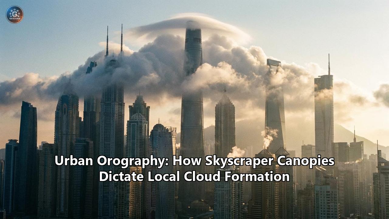
This phenomenon brings us to the fascinating frontier of urban orography. Borrowed from the geological term for the study of mountains and their impact on weather, urban orography examines how skyscraper canopies, dense city blocks, and sprawling concrete jungles physically alter the lower atmosphere. By acting as artificial mountains, our cities force air upward, generate their own thermal updrafts, and seed the sky with microscopic particles, culminating in the creation of localized cloud formations and "homemade" rainstorms.
The realization that cities are meteorological engines is completely changing how we understand urban living, civil engineering, and climate resilience. To fully grasp how a cluster of skyscrapers can conjure a thunderstorm out of thin air, we must explore the mechanical, thermodynamic, and chemical forces at play within the modern urban canopy.
The Mechanical Lift: Cities as Artificial Mountains
In the natural world, orographic cloud formation is a well-understood process. When a prevailing wind encounters a physical barrier—like the Himalayas, the Alps, or the Rocky Mountains—the air mass has nowhere to go but up. As this air is forced higher into the troposphere, it experiences a drop in atmospheric pressure. The air expands and cools adiabatically. Because cold air cannot hold as much water vapor as warm air, the relative humidity spikes. Once the temperature drops to the dew point, the invisible water vapor condenses into liquid droplets, forming clouds, and eventually, precipitation. This is why the windward side of a mountain range is typically lush and wet, while the leeward side is caught in a dry "rain shadow".
A modern high-rise city mimics this exact topographic process, albeit on a micro-scale. While a 1,000-foot skyscraper is dwarfed by a 10,000-foot mountain peak, a dense cluster of skyscrapers creates a massive wall of friction. In fluid dynamics, this is referred to as "surface roughness." Natural landscapes like grasslands and forests have a relatively low roughness length, allowing the wind to glide over them with minimal resistance. A city skyline, by contrast, is an incredibly rough, jagged surface.
When a horizontal mass of moving air hits a dense urban canopy, the physical obstruction of the buildings forcefully decelerates the wind at the surface level. Because the air behind it is still pushing forward, this creates a localized "traffic jam" in the atmosphere, known as low-level wind convergence. With the horizontal path blocked or slowed by the sheer mass of concrete and glass, the converging air is mechanically forced upward.
As this urban air is pushed higher into the cooler layers of the atmosphere, it undergoes the same adiabatic cooling process as air climbing a natural mountain. If the incoming air mass contains enough moisture, this mechanical lifting will push the air parcel past its Lifted Condensation Level (LCL)—the exact altitude where the air becomes fully saturated. Suddenly, fluffy cumulus clouds begin to aggregate directly over the downtown grid. If the updraft is sustained, these clouds will build vertically into towering cumulonimbus clouds, culminating in a localized downpour.
The Thermodynamic Engine: The Urban Heat Island
While the mechanical lifting of air by skyscrapers is a critical factor, it is only one piece of the urban weather puzzle. The city’s ability to generate clouds is massively amplified by its thermodynamics, primarily through a phenomenon known as the Urban Heat Island (UHI) effect.
Cities are inherently hot. They are largely stripped of the natural vegetation that usually cools the environment through shade and evapotranspiration (the process by which plants release water vapor into the air). Instead, the urban landscape is paved with asphalt, brick, dark roofing materials, and concrete. These materials possess a high thermal mass and low albedo, meaning they are exceptionally efficient at absorbing shortwave solar radiation during the day and storing it as heat.
Furthermore, human activities inject a constant stream of "waste heat" into the urban environment. The exhaust from millions of internal combustion engines, the expelled hot air from countless HVAC units, the heat generated by industrial plants, and even the collective body heat of millions of people all contribute to the city’s thermal signature. Consequently, urban centers can be significantly warmer than their surrounding rural areas—sometimes by as much as 10°F (approx. 5.5°C) on a clear, calm afternoon, and this temperature gap often persists or even widens at night as the city slowly bleeds its trapped heat back into the sky.
This intense localized heat fundamentally alters the stability of the boundary layer (the lowest part of the atmosphere that is directly influenced by the Earth's surface). Hot air is less dense than cold air, making it naturally buoyant. As the concrete jungle bakes in the sun, it acts like a giant stovetop, heating the air immediately above it. This creates powerful, invisible columns of rising warm air known as thermal updrafts.
When these thermal updrafts combine with the mechanical lifting caused by the skyscraper canopy, the effect is supercharged. Meteorologists refer to this as achieving the Convective Condensation Level (CCL). On days when the regional weather is relatively calm and "weakly forced" (meaning there are no massive natural fronts moving through), the intense daytime heating of a city can single-handedly force near-surface air to rise fast and high enough to achieve saturation. The result is the spontaneous generation of thunderstorms that seem to materialize out of nowhere. Meteorologists have even coined informal terms for this phenomenon, such as "Sunset Sprouters"—pop-up thunderstorms that ignite just as the sun goes down, fueled by the peak accumulation of urban heat and the sudden mechanical lifting of evening breezes.
The Microscopic Architects: Cloud Seeding by Aerosols
Mechanical lift provides the upward push, and urban heat provides the sustained energy. But for a cloud to actually form, it needs one more crucial ingredient: something for the water vapor to grab onto.
In a perfectly clean atmosphere, water vapor struggles to condense into liquid droplets, even when the air is cooled past its dew point. It requires microscopic solid or liquid particles suspended in the air to act as an anchor. These particles are known as Cloud Condensation Nuclei (CCN). In nature, CCN consist of sea salt, dust, volcanic ash, or natural organic compounds released by forests.
Cities, however, are prolific manufacturers of artificial CCN. The exhaust from millions of cars and trucks, the emissions from power plants, the soot from industrial factories, and the dust kicked up by constant construction all fill the urban canopy with a dense, invisible smog of aerosols. When the warm, moist air of the city is pushed upward by the UHI effect and the skyscraper canopy, it carries this heavy payload of microscopic pollution right into the condensation zone.
The introduction of urban aerosols fundamentally changes the microphysics of the resulting clouds. Because there is an overabundance of condensation nuclei over a city, the available water vapor is distributed across a much larger number of particles. This results in the formation of clouds that consist of millions of very small droplets, rather than fewer, larger droplets.
Initially, this process—known as the aerosol indirect effect—can actually delay the onset of rain. Because the droplets are so small, they do not possess enough mass to overcome the updraft and fall to the ground as precipitation. The cloud simply continues to grow, drawing in more moisture and more pollution, swelling into a massive, looming presence over the city.
However, when these droplets eventually do coalesce and reach a critical mass, or when the updraft finally weakens, the resulting downpour is often explosive. The prolonged growth phase allows the storm to stockpile an enormous amount of water. When the "dam breaks," it leads to hyper-intense, localized torrential rains that can quickly overwhelm urban drainage systems. In this way, urban pollution does not just create clouds; it alters the timing, intensity, and severity of the rainfall.
The "Urban Wet Island": Downwind Deluges and Split Storms
The culmination of urban orography, thermal updrafts, and aerosol seeding results in a measurable meteorological anomaly known as the "Urban Wet Island" effect. Extensive research analyzing decades of satellite and radar data has shown that cities routinely receive more precipitation than their rural fringes. But surprisingly, the most dramatic effects are often felt not directly over the downtown core, but just downwind of the city limits.
When an air mass moves over a city, the process of generating a thunderstorm takes time. The air must be lifted, the moisture must cool and condense, and the droplets must grow large enough to fall. Because the atmosphere is in constant horizontal motion, the storm system is typically blown several miles downwind before it reaches maturity. As a result, the suburban and rural communities located on the leeward side of major metropolises often experience significantly higher rates of rainfall and more severe weather than areas upwind.
A landmark study led by researchers at Purdue University analyzed precipitation data for over 1,000 cities globally. They found that 63 percent of the analyzed urban centers received more annual precipitation than their surrounding rural areas. In Ho Chi Minh City, Vietnam, the urban influence accounted for an astonishing 274 millimeters (about 11 inches) of extra rainfall per year. The sprawling metropolis of Guangzhou-Shenzhen in China received an extra 186 millimeters, while Houston, Texas, saw an added 124 millimeters. The study also highlighted that the intensity of these "urban wet islands" has nearly doubled over the past two decades, directly tracking with the rapid expansion of urban sprawl and the vertical growth of city skylines.
The geography of the city itself dictates exactly how this artificial weather manifests. Houston, for example, sits near the Gulf Coast. During the summer, cool sea breezes roll inland off the water. For a long time, meteorologists assumed this sea breeze would disperse Houston's urban heat and prevent localized storms. However, radar mapping revealed the exact opposite. The collision between the cool, moving sea breeze and the stationary, intensely hot air mass brooding over Houston's concrete grid acts like "the front ends of two cars that hit head on," according to NASA researchers. This violent collision forces the moist air straight up into the atmosphere, rapidly pumping energy into the sky and triggering severe, sudden thunderstorms right over the city.
In other scenarios, cities act less like a ramp and more like a boulder in a fast-flowing stream. When a large, naturally occurring storm front approaches a dense urban area, the skyscraper canopy can actually bifurcate the storm. The massive block of hot, turbulent air sitting over the city creates a high-pressure dome that forces the approaching storm system to split, traveling around the left and right flanks of the metropolitan area. These split storm cells often merge back together on the leeward side of the city. When they collide, the convergence of the two fronts, combined with the heat and aerosols absorbed from the city, can result in extreme, localized deluges in the downwind suburbs.
The Canyons of Glass: Turbulence and Microclimates
To understand the mechanics of urban orography, we must also zoom in from the macro-scale of a city skyline to the micro-scale of the streets below. The placement, spacing, and geometric design of tall buildings create complex aerodynamic features known as "urban canyons".
In a natural setting, wind flows relatively smoothly, governed by the predictable friction of the terrain. But when wind enters a city grid, it is forced into the narrow corridors between towering skyscrapers. This triggers a phenomenon known as the Venturi effect. As a volume of air is forced through a constricted space—like a narrow avenue flanked by 50-story buildings—its velocity increases dramatically, while its static pressure decreases. This is why certain street corners in cities like Chicago (famously nicknamed the "Windy City" in part due to its early adoption of high-rises) or Manhattan can feel like a wind tunnel, even on a relatively calm day.
These accelerated winds within the urban canopy do not just travel horizontally; they create intense vertical turbulence. When high-speed wind hits the flat, broad face of a skyscraper, it is forced in all directions. Some of the air is pushed down to the street level, creating a "downwash" effect that can knock pedestrians off balance. But a significant portion of that air is deflected violently upward.
This chaotic, turbulent mixing is crucial for local cloud formation. It takes the stagnant, superheated, and polluted air trapped at the street level and rapidly ejects it upward into the boundary layer. The varied heights of modern buildings further exacerbate this effect. A skyline with buildings of uniform height acts almost like a raised plateau, allowing wind to eventually glide over the top. But a skyline with highly variable building heights—a 20-story building next to a 60-story building, next to a 10-story building—acts like a jagged set of teeth. This "aerodynamic roughness" shreds the wind, generating massive eddies and vertical vortices that continuously pump urban heat and moisture into the upper atmosphere, feeding the very mechanisms that construct localized cloud cover.
The Danger of Designing Our Own Weather
The realization that cities dictate their own weather is not merely an interesting atmospheric quirk; it has profound and immediate ramifications for human safety, urban planning, and civil infrastructure.
As the global climate changes, the baseline for extreme weather is already shifting. Warmer global temperatures mean the atmosphere can hold more moisture, leading to heavier baseline rainfall. When you superimpose the "Urban Wet Island" effect on top of this global trend, you create a recipe for catastrophic localized flooding.
Cities are uniquely vulnerable to precipitation. Unlike a natural landscape where rainfall is absorbed into soil, wetlands, and root systems, a city is covered in impervious surfaces—asphalt, concrete, and tightly packed earth. When an urban-induced thunderstorm unloads billions of gallons of water over a city, none of it can soak into the ground. It all instantly becomes surface runoff.
This runoff must be managed by the city's stormwater drainage systems, many of which were designed and built decades—or even a century—ago, based on historical rainfall data that did not account for the city's own orographic magnification. When a "storm on steroids" (as researchers describe urban-amplified rain) hits, it rapidly overwhelms the subterranean pipes. The water backs up, turning streets into rivers, flooding subway systems, and destroying subterranean infrastructure. The devastating flash floods seen in major cities worldwide in recent years are heavily exacerbated by the very concrete structures that surround them.
Furthermore, the spatial variability of this rainfall makes it incredibly difficult for meteorologists to forecast accurately. Traditional weather models are based on synoptic-scale data—broad regional trends. But urban orography operates on a micro-scale. The specific layout of a city block, the albedo of a new high-rise, or the localized heat output of a specific industrial district can trigger a localized deluge that floods a three-square-mile neighborhood while leaving the rest of the city completely dry.
Architectural Meteorology: Building for a New Sky
If our current method of building cities has unintentionally engineered a hostile sky, the question becomes: Can we intentionally design our cities to mitigate these effects, or even leverage them? The burgeoning discipline of urban microclimatology suggests we can. By treating urban design as a form of atmospheric engineering, architects and city planners are exploring ways to dismantle the UHI effect and smooth out urban orography.
Ventilation CorridorsOne of the most effective strategies is rethinking the city grid to promote airflow. In cities with deeply entrenched urban canyons, heat and moisture become trapped. By designing "ventilation corridors"—wide, strategically aligned avenues or parks that match the prevailing wind directions—planners can allow regional breezes to sweep through the city. This horizontal airflow flushes out trapped heat and aerosol pollution, disrupting the vertical thermal updrafts required to build towering storm clouds. Several Asian mega-cities, such as Beijing and Hong Kong, have actively begun incorporating these wind corridors into their zoning laws to improve air quality and reduce localized heat accumulation.
Altering the Thermal SignatureTo combat the UHI effect, the thermal properties of the city must be changed. This involves a mass transition away from dark, heat-absorbing materials. Painting rooftops white or using reflective roofing materials dramatically increases a city's albedo, bouncing solar radiation back into space before it can be absorbed and converted into thermal updrafts.
Furthermore, the integration of green infrastructure is paramount. Green roofs and living walls replace barren concrete with vegetation. This not only prevents the building from acting as a thermal battery, but it also introduces localized evaporative cooling. As the plants transpire, they cool the air immediately around them, breaking up the massive heat domes that fuel urban cloud formation. Replacing impervious parking lots with permeable pavements and expanding urban parks also allows rainfall to cool the ground and be naturally absorbed, mitigating both the heat island and the flooding risk simultaneously.
Aerodynamic Skyline ZoningAs we understand more about how the physical geometry of a skyline shreds wind and forces it upward, future urban planning may involve aerodynamic zoning. Planners can mandate varying setbacks, tapered building crowns, and specific spatial distributions of high-rises to reduce surface roughness. By designing a skyline that allows wind to flow smoothly over and around it—rather than slamming into a vertical wall of glass—cities can reduce the mechanical lifting that triggers artificial orographic precipitation.
The Ultimate Convergence of Earth and City
Humanity has long viewed the city as a shelter from nature—a fortress of concrete and climate control designed to keep the elements at bay. But the study of urban orography reveals a profound truth: we are never separate from the environment. Through the sheer scale of our engineering, the friction of our architecture, and the heat of our daily existence, we have turned our cities into geological forces.
The skyscrapers that define our modern era are more than monuments to human ambition; they are the peaks of a new, synthetic mountain range. They catch the wind, they cook the air, and they seed the sky. As we look to the future, the survival and sustainability of the modern metropolis will not just depend on how well it can withstand the weather, but on a deep, scientific understanding of the weather it creates. The sky above the city is not just an empty void waiting for the next storm to roll in—it is a living, breathing extension of the streets below.
Reference:
- https://time.com/archive/6669269/how-cities-make-their-own-weather/
- https://www.earthdata.nasa.gov/dashboard/stories/urban-effects
- https://www.carriermanagement.com/news/2024/09/16/266389.htm
- https://en.wikipedia.org/wiki/Orographic_precipitation
- https://earthweb.ess.washington.edu/roe/GerardWeb/Publications_files/MinderRoe_OrogPrecEncyc.pdf
- https://www.epa.gov/heatislands/what-are-heat-islands
- https://www.forbes.com/sites/marshallshepherd/2016/06/01/can-cities-create-their-own-thunderstorms/
- https://en.wikipedia.org/wiki/Urban_heat_island
- https://www.ayresassociates.com/how-to-minimize-the-impact-of-urban-heat-islands/
- https://blog.worldweatheronline.com/weather/urban-microclimates-how-cities-create-their-own-weather/
- https://www.anthropocenemagazine.org/2018/03/cities-make-their-own-weather-in-ways-that-may-intensify-with-climate-change/
- https://www.researchgate.net/publication/384471062_Initiation_and_evolution_of_urban-induced_precipitation_under_different_background_wind_speeds_Roles_of_urban_breeze_circulation_and_cold_pool
- https://www.researchgate.net/publication/223399753_Comparisons_of_model_simulations_with_observations_of_mean_flow_and_turbulence_within_simple_obstacle_arrays
- https://ntrs.nasa.gov/citations/19950051838