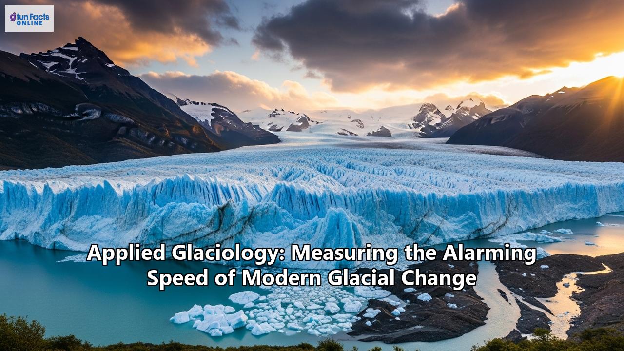
An Unforgiving Pace: How Applied Glaciology Reveals the Alarming Speed of Modern Glacial Change
In the vast, frozen expanses of our planet, from the towering peaks of the Himalayas to the immense, continent-spanning ice sheets of Antarctica and Greenland, a dramatic and unsettling transformation is underway. Glaciers, the Earth's majestic rivers of ice, are shrinking, thinning, and accelerating their march to the sea at a pace that is historically unprecedented. This is not a slow, gentle retreat, but a rapid, often violent, unraveling of the world's cryosphere. The sentinels of our climate system are sounding a shrill alarm, and it is the field of applied glaciology that provides the tools and the expertise to measure, understand, and ultimately, bear witness to this alarming speed of change.
This is a story of science on the edge, of researchers braving sub-zero temperatures and treacherous terrain to gather data that is vital for the future of our planet. It is a narrative written in the language of satellite data, ice core chemistry, and seismic waves, a story that reveals not only the staggering scale of ice loss but also its profound and cascading consequences for millions of people worldwide. Through the lens of applied glaciology, we can begin to comprehend the true velocity of our changing world.
The Pulse of the Planet: A Discipline Forged in Ice
Glaciology, the scientific study of ice and the natural phenomena involving it, has its roots in the 19th-century explorations of the European Alps. Early pioneers like Louis Agassiz first proposed the revolutionary idea of past ice ages, recognizing that glaciers had once been far more extensive. These early studies were born of romantic enthusiasm for nature and the rigorous application of classical physics, a compelling mixture that still draws scientists to the field today.
Modern applied glaciology has evolved into a deeply interdisciplinary Earth science, integrating geophysics, geology, climatology, hydrology, and even biology and ecology. A glaciologist might be a geophysicist using radar to map the bedrock beneath a two-mile-thick ice sheet, a chemist analyzing ancient air bubbles trapped in an ice core, or a computer scientist developing models to forecast future sea-level rise. Their laboratories are often the most remote and hostile environments on Earth, from the high-altitude "Third Pole" of the Himalayas to the storm-battered coasts of Greenland.
The central task of this discipline is to understand the glacier's "mass balance" – the delicate and now dangerously disrupted equilibrium between accumulation (gaining ice from snowfall) and ablation (losing ice through melting, sublimation, and calving). For a glacier to remain stable, accumulation must equal ablation. However, in our warming world, the scales have tipped dramatically. For 37 consecutive years, the world's reference glaciers have lost more ice than they have gained, a stark testament to a system profoundly out of balance. Applied glaciology is the science of quantifying this deficit, measuring its acceleration, and predicting its far-reaching consequences.
The Glaciologist's Toolkit: Measuring a World in Flux
To measure the pulse of the planet's ice, glaciologists deploy a sophisticated and ever-evolving array of technologies, turning frozen wildernesses into data-rich landscapes. These tools allow them to track changes in three dimensions and across decades, revealing the startling velocity of glacial decline.
The View from Above: Satellites as Sentinels
The advent of remote sensing has revolutionized glaciology, offering a vantage point that is both vast and detailed. Before satellites, monitoring was limited to a few accessible glaciers. Now, scientists can track nearly all of the world's 220,000 glaciers.
- Mapping Change with Optical Imagery: Satellites like NASA's Landsat and Terra (with its ASTER sensor) have been collecting images of the Earth for decades. By comparing images from different years, scientists can create detailed timelines of glacier retreat. For example, studies in Patagonia have used this historical archive to track glacier recession from the late 19th century to the present day, providing a long-term context for the recent acceleration. This technique was used to document the 950-meter retreat of the Chhota Shigri glacier in the Indian Himalayas between 1962 and 2008.
- Measuring Height and Volume with Altimetry: Satellite radar altimeters, like those on ESA's CryoSat-2, and laser altimeters, on NASA's ICESat and its successor ICESat-2, measure the height of the ice surface with incredible precision. By repeatedly measuring the same area, scientists can calculate changes in ice volume. It was data from these missions that revealed Greenland lost an average of 200 gigatonnes of ice per year, and Antarctica lost 118 gigatonnes per year between 2003 and 2019. These missions are crucial for understanding the ice sheets' contribution to sea-level rise.
- Tracking Speed with Radar and Feature Tracking: Two primary satellite methods are used to clock the speed of glaciers. Feature tracking uses pairs of optical or radar images to algorithmically track the movement of surface features like crevasses over time. Synthetic Aperture Radar (SAR) interferometry (InSAR) uses the phase difference between two radar images taken at different times to detect movement with centimetre-level accuracy. These techniques have been essential in discovering the dramatic acceleration of outlet glaciers in Greenland and Antarctica. For instance, Greenland's Jakobshavn glacier was clocked moving at 150 feet per day in 2012, nearly three times its speed in the 1990s.
- Peering Beneath the Ice with Radar: Certain radar frequencies can penetrate deep into the ice, reflecting off the bedrock below. This allows scientists to create detailed maps of the subglacial topography, information that is critical for understanding why glaciers flow the way they do and for building accurate ice flow models.
On the Ground: The Enduring Value of Fieldwork
Despite the power of satellites, there is no substitute for direct, on-the-ice measurements. Fieldwork is arduous, logistically complex, and often dangerous, but it provides the ground truth that calibrates and validates satellite data.
- The Glaciological Method: The classic way to measure mass balance involves trekking onto a glacier to install a network of "ablation stakes" – long poles drilled deep into the ice. By measuring how much of the stake is exposed at the end of the melt season, scientists get a precise point measurement of ice loss. In the accumulation zone, they dig snow pits to measure the amount of new snow that has fallen. These labour-intensive measurements, collected from a global network of "reference glaciers," provide some of the longest and most reliable climate records we have.
- GPS for Precision Tracking: Just as we use GPS for navigation, glaciologists use high-precision GPS units to track glacier movement. By leaving a GPS receiver on a glacier for an extended period, they can measure its velocity and how it changes over time, sometimes even observing daily or tidal cycles in flow. An innovative new technique, GPS-reflectometry, uses reflected GPS signals like a form of radar to determine the properties of the snow or ice surface, such as whether it is wet or dry, which is crucial for understanding melt dynamics.
- Geophysical Exploration: Seismic and Radar: To see inside and beneath a glacier from the ground, glaciologists turn to geophysical methods. Ground-penetrating radar (GPR) systems are dragged across the surface on sleds to create detailed cross-sections of internal layers and map the bedrock below. Seismic surveying involves creating a sound wave—often with a simple sledgehammer blow on a metal plate or a small explosive charge—and recording the echoes that bounce back from the bed of the glacier. This helps determine not just ice thickness but also the nature of the material underneath—be it hard rock or soft, water-saturated sediment, a key factor controlling how fast a glacier can slide. In recent years, passive "glacial seismology" has emerged, using sensitive seismometers to "listen" to the creaks, groans, and water flow within the ice, providing insights into processes like iceberg calving and basal motion.
Archives of the Past: The Secrets of Ice Cores
To understand the speed and uniqueness of today's changes, scientists must look to the past. Glaciers and ice sheets are unparalleled archives of Earth's climate history, and ice cores are the key to unlocking it. Using specialized drills, scientists extract cylinders of ice, sometimes miles long, that contain a layered record of past millennia.
- Reconstructing Past Climates: Each layer of ice represents a year's snowfall, and its chemical composition reveals the conditions at the time it formed. By analyzing the isotopic ratios of oxygen and hydrogen in the ice, scientists can reconstruct past temperatures with remarkable accuracy.
- Trapped Bubbles of Ancient Air: As snow compacts into ice, it traps tiny bubbles of the surrounding atmosphere. By carefully melting the ice in a vacuum and analyzing these bubbles with a mass spectrometer, glaciologists can directly measure the concentration of past greenhouse gases like carbon dioxide and methane. It is through this method that we know that current CO2 levels are higher than at any point in at least 800,000 years. These ancient archives provide the irrefutable context that shows today's warming and the resulting glacial melt are an anomaly.
The Verdict: A World Losing its Ice at an Unprecedented Rate
The collective evidence gathered through these sophisticated techniques paints a stark and globally coherent picture: the world's ice is vanishing at a speed that is accelerating decade by decade.
The Ice Sheet Giants: Greenland and Antarctica
The planet's two great ice sheets, which together hold enough ice to raise global sea levels by over 200 feet, are losing mass at a stunning rate. A landmark series of studies known as the Ice Sheet Mass Balance Inter-comparison Exercise (IMBIE) combines data from multiple satellites to provide the most complete picture of this loss. The studies found that between 1992 and 2017, Greenland and Antarctica shed a combined 6.4 trillion tonnes of ice, raising global sea levels by 17.8 millimetres.
The most alarming finding is the acceleration. The combined rate of ice loss increased six-fold, from 81 billion tonnes per year in the 1990s to a staggering 475 billion tonnes per year in the 2010s. This means the polar ice sheets alone are now responsible for a third of all sea-level rise.
- Greenland: The Greenland Ice Sheet is losing mass at an average rate of about 267 billion tons per year. The primary drivers are twofold: warmer air temperatures melting the surface of the ice sheet, creating rivers of meltwater that pour into the ocean, and warmer ocean waters attacking the edges of the glaciers that flow into the sea, causing them to speed up and calve more icebergs.
- Antarctica: While the vast and cold East Antarctic Ice Sheet remains relatively stable, West Antarctica is a region of profound concern. Antarctica as a whole is losing an average of 136 billion tons of ice per year. Here, the main culprit is the intrusion of warm ocean water that melts the floating ice shelves from below. These ice shelves act like a cork in a bottle, buttressing the glaciers behind them. As they thin and weaken, this resistance is lost, and the glaciers accelerate their flow into the ocean.
Mountain Glaciers: The Disappearing Water Towers
The retreat of mountain glaciers is one of the most visible indicators of climate change. A 2021 study published in Nature provided the most comprehensive assessment of all 220,000 mountain glaciers, finding that between 2000 and 2019, they lost an average of 267 gigatonnes of ice each year. This melt is responsible for 21% of observed sea-level rise.
The speed of this loss has also doubled over the past two decades.
- The Himalayas: Glaciers in the Hindu Kush Himalaya region are melting at an "exceptional" rate. Research has shown that recent ice loss is at least ten times faster than the average rate over the preceding centuries since the "Little Ice Age." The glaciers have lost about 40% of their area from their peak 400-700 years ago. This is a profound threat to the water supply for millions of people in Asia.
- The Alps: The glaciers in the European Alps are among the fastest-melting in the world. Due to their relatively low elevation and smaller size, they are particularly vulnerable. Some projections suggest that at the current rate of loss, 80-90% of Alpine glacier ice could be gone by 2050.
- The Andes: Glaciers in the tropical Andes have shrunk by 30-50% in just 30 years. In Peru, which is home to 70% of the world's tropical glaciers, the glacial area was reduced by around 43% between 1970 and 2010. This rapid retreat is creating a dire situation for water resources in countries like Peru, Bolivia, and Chile.
- Alaska: Alaskan glaciers are losing mass faster than almost anywhere else, accounting for about 25% of the global mass loss from mountain glaciers. The retreat rate of some glaciers in western North America has quadrupled.
This staggering loss of ice is not a distant, abstract problem. It has immediate and dangerous consequences that are already being felt around the world.
Cascading Consequences: When the Ice Gives Way
The rapid melting of the cryosphere unleashes a cascade of hazards and impacts that ripple outwards from the high mountains and polar regions to affect coastal cities and riverside communities globally.
The Fury of the Flood: Glacial Lake Outbursts (GLOFs)
As glaciers retreat, they often leave behind large depressions that fill with meltwater, forming glacial lakes. These lakes are frequently dammed by unstable walls of moraine—loose rock and debris left by the glacier—or by the ice itself. When these dams fail, they can release enormous volumes of water in a catastrophic event known as a Glacial Lake Outburst Flood (GLOF).
The Hindu Kush Himalaya region is a global hotspot for GLOFs.
- In June 2013, a GLOF in the Kedarnath region of Uttarakhand, India, combined with torrential rain, led to devastating floods that killed over 6,000 people.
- In February 2021, a rock and ice avalanche in Uttarakhand's Rishi Ganga valley triggered a chain of events that resulted in a deadly flood, killing over 200 people and destroying two hydropower plants.
- In October 2023, the South Lhonak lake in Sikkim burst its banks, leading to the collapse of a major hydroelectric dam and causing over 100 deaths and widespread devastation downstream.
Scientists in the region warn that the risk is increasing. The number of glacial lakes is growing, and existing ones are expanding. ICIMOD, the International Centre for Integrated Mountain Development, has noted an "unprecedented" acceleration in these events. Applied glaciology is crucial for mitigating this threat. By using satellite imagery to monitor the growth of these lakes and deploying on-site monitoring systems, scientists can develop early warning systems to give downstream communities precious time to evacuate.
From Peak Water to Water Scarcity
For hundreds of millions of people, mountain glaciers act as critical frozen water towers. They store water as snow in the wet season and release it as meltwater during the dry season, providing a reliable supply for drinking, agriculture, and hydropower generation. But as glaciers shrink, this system is being dangerously disrupted.
Initially, increased melting can lead to a temporary boost in river flows, a phenomenon known as "peak water." But as the glacier continues to shrink, there is less and less ice to melt, and the runoff begins a terminal decline.
- The Andes: This region is already experiencing the acute effects of water stress. La Paz, Bolivia, which relies on glaciers for up to 85% of its water during the driest months of a drought year, has already faced severe water rationing. In Chile, Santiago's primary water source, the Maipo River, could see its flow reduced by 40% by 2070 due to glacier retreat. This threatens not only urban water supplies but also food security and the region's vast hydropower infrastructure, which provides over 70% of the energy in countries like Colombia and Ecuador.
- Central Asia: In the Tien Shan and Pamir mountains, meltwater supplies around 80% of the total river runoff, feeding major rivers like the Amu Darya and Syr Darya. By 2050, the flow of these vital arteries could be significantly reduced, posing a serious threat to irrigated agriculture and energy security in Kyrgyzstan, Tajikistan, Uzbekistan, and Kazakhstan.
The Rising Tide: Global Sea-Level Rise
The most far-reaching consequence of ice loss is sea-level rise. Every gigatonne of ice that melts and flows into the ocean adds to the volume of the world's seas. As noted, melt from glaciers and ice sheets is the dominant driver of sea-level rise today. The IMBIE team's finding that the rate of loss from the ice sheets is tracking the IPCC's worst-case warming scenario is deeply concerning. If this trend continues, the ice sheets alone could contribute an additional 17 centimeters to sea-level rise by 2100, which would put 400 million people at risk of annual coastal flooding.
The Human Element: Life on the Front Lines of Climate Change
Behind the data and the satellite images are the scientists themselves, individuals who dedicate their lives to working in some of the most physically and mentally demanding conditions on the planet. Their stories add a vital human dimension to the science of glacial change.
Glaciologist Dr. M. Jackson speaks of the need to find a way to care for the ice, to fight for it, and to have a more inclusive conversation about what its loss means. "We see a lot of headlines that say glaciers are melting and that glaciers are going away and it's almost like we don't care," she states, challenging us to redefine our relationship with the world's frozen landscapes.
The physical challenges are immense. Fieldwork can mean spending months without a shower, as glaciologist Sarah Wells-Moran recounted after spending eight weeks on the Juneau Icefield. It means facing temperatures that can drop below -30°C, navigating treacherous crevassed terrain, and the constant risk of being buried by sudden, heavy snowfall.
Dr. Eric Rignot, a leading glaciologist, took his filmmaker daughter on a perilous expedition to northern Greenland to survey the massive Humboldt glacier for the first time. Their journey involved dodging icebergs and battling severe storms hundreds of miles from help. "You risk your boat, you risk your life," he noted. These researchers are not just dispassionate observers; they are witnesses on the front lines. As pioneering glaciologist Lonnie Thompson, who has been studying ice for decades, puts it, "This current warming is not typical. It is happening faster, it is more persistent and it is affecting glaciers in both Peru and India. And that is a problem, because a lot of people rely on those glaciers for their water.”
The Future of Applied Glaciology: Innovation in the Face of Crisis
As the pace of change accelerates, so too does the pace of innovation in glaciology. Scientists are developing new tools and techniques to improve their monitoring and predictive capabilities.
- The AI Revolution: Artificial intelligence and machine learning are poised to transform glaciology. Traditional ice flow models are computationally expensive, limiting the number of simulations that can be run. New models are using deep learning—a type of AI—to emulate the complex physics of glacier dynamics, speeding up simulations by a factor of a thousand. This allows researchers to run more scenarios and better predict the future evolution of glaciers under different climate pathways, which is crucial for refining sea-level rise projections. AI is also being used to automate the process of mapping glaciers from the vast archives of satellite imagery.
- New Eyes in the Sky: A new generation of satellites promises to provide an even clearer view of the cryosphere. The recently launched Surface Water and Ocean Topography (SWOT) mission and the upcoming NASA-ISRO Synthetic Aperture Radar (NISAR) mission will provide unprecedented detail on water levels and ice motion. ESA's Copernicus program is developing missions like CRISTAL, which will carry an advanced dual-frequency radar altimeter to measure sea ice thickness and glacier height with greater accuracy than ever before.
- Robots on the Ice: To overcome the dangers and logistical challenges of fieldwork, scientists are increasingly turning to autonomous systems. In Alaska, a team is using an autonomous boat to deploy a remotely operated vehicle (ROV) that can drill instruments directly into the vertical face of a calving glacier—a location far too dangerous for humans to approach. In the future, swarms of small marine robots could be released to explore the hidden cavities beneath ice shelves where warm ocean water is doing its most destructive work. Other researchers are developing "cryobots"—autonomous probes designed to melt their way through miles of ice to explore the subglacial lakes of Antarctica or even the frozen oceans of moons like Europa.
A Race Against Time
Applied glaciology is a science in a race against time. Its practitioners work with a profound sense of urgency, acutely aware that the landscapes they study are disappearing before their eyes. The data they collect is not merely academic; it is a critical input for global policy on climate change, for engineering decisions on coastal defenses, and for water management strategies that will affect the lives of billions.
The message from the ice is unequivocal. The alarming speed of modern glacial change is a direct and dramatic consequence of a warming planet. The tools of applied glaciology have allowed us to measure this change with stunning precision, moving it from the realm of abstract prediction to observed fact. The challenge now lies not in the science, but in our collective will to act on the clear and urgent warning that the world's melting glaciers have delivered.
Reference:
- https://news.osu.edu/climate-change-leading-to-water-shortage-in-andes-himalayas/
- https://www.jpl.nasa.gov/news/this-us-indian-satellite-will-monitor-earths-changing-frozen-regions/
- https://www.greendreamer.com/podcast/dr-m-jackson-glaciologist
- https://www.youtube.com/watch?v=PvptZ-WWolY
- https://www.theguardian.com/world/video/2017/jan/20/interview-jason-roberts-antarctica-video
- https://thinklandscape.globallandscapesforum.org/34274/whats-happening-with-water-in-central-asia/
- https://www.youtube.com/watch?v=W7-RbO5WjxE
- https://zenodo.org/records/15533136
- https://thecityfix.com/blog/4-andean-cities-adapting-glacier-retreat-preserve-water-security-kate-cullen/
- https://arctic-council.org/news/understanding-our-cryosphere-through-earth-observation-satellites/
- https://www.uu.nl/en/news/artificial-intelligence-helps-scientists-to-better-predict-the-evolution-of-glaciers-under-climate
- https://www.trees-dla.ac.uk/projects/advanced-remote-sensing-cryosphere-new-generation-satellites
- https://unrcca.unmissions.org/sites/default/files/old_dnn/Glacier%20Melting%20Brochure_ENG.pdf
- https://www.inrae.fr/en/news/artificial-intelligence-helps-scientists-better-predict-evolution-glaciers-under-climate-change
- http://www.saisperspectives.com/22-23issue/andes-glacial-retreat
- https://www.hindustantimes.com/environment/himalayan-glacial-lake-outbursts-are-a-growing-threat-to-south-asia-101713972618434.html
- https://pubs.usgs.gov/publication/sim3322
- https://news.climate.columbia.edu/2023/02/10/glacial-melting-in-high-mountain-asia-has-the-potential-to-overwhelm-hydropower-systems/
- https://www.mdpi.com/2072-4292/15/7/1941
- https://zeenews.india.com/india/himalayan-floods-glof-llof-explained-risks-solutions-2942646.html
- https://gracefo.jpl.nasa.gov/resources/37/two-new-missions-set-to-study-one-of-earths-most-critically-changing-regions/
- https://www.copernicus.eu/en/news/news/observer-advancing-earth-observation-copernicus-sentinel-expansion-missions
- https://egusphere.copernicus.org/preprints/2024/egusphere-2024-565/egusphere-2024-565.pdf
- https://rwe.climatecase.org/en/blog-posts/article/melting-glaciers-andes-problem-water-supply
- https://www.mdpi.com/2225-1154/13/3/60
- https://www.researchgate.net/publication/390632526_Glacial_lake_outburst_floods_GLOFs_causes_modeling_and_mitigation_in_Indian_Himalayan_region
- https://www.downtoearth.org.in/climate-change/hindu-kush-himalayas-seeing-dramatic-rise-in-glacial-origin-floods-recent-events-triggered-by-nascent-glacial-lakes-icimod
- https://egusphere.copernicus.org/preprints/2024/egusphere-2024-565/
- https://dendrolab.ch/wp-content/uploads/2018/10/Sorg_etal_NCC_2012.pdf
- https://centralasiaclimateportal.org/kyrgyzstan-lost-over-16-per-cent-of-glaciers-in-the-last-50-years-drought-risk-gets-real-to-the-whole-region/
- https://www.youtube.com/watch?v=51vynTID2ic
- https://blogs.egu.eu/divisions/cr/2022/04/29/current-challenges-high-altitude-chilean-glacier-monitoring-in-an-extended-drought/
- https://news.climate.columbia.edu/2022/03/25/machine-learning-techniques-can-speed-up-glacier-modeling-by-a-thousand-times/
- https://www.mdpi.com/2073-4441/16/16/2272
- https://www.youtube.com/watch?v=fmmAdk9gNj4
- https://media.statler.wvu.edu/news/2023/09/26/wvu-researcher-to-help-send-swarm-of-marine-robots-on-climate-change-quest-beneath-ocean-ice
- https://www.cambridge.org/core/journals/annals-of-glaciology/article/progress-towards-an-optically-powered-cryobot/33B377D112246F4F0EE48CC8EEA8EAB0
- https://www.researchgate.net/publication/267778813_Cryobots_An_Answer_to_Subsurface_Mobility_in_Planetary_Icy_Environments