Approximately 50,000 years ago, the dense, ancient forests of what is now northeastern China were abruptly violently illuminated. A hypervelocity extraterrestrial object, hurtling through the Pleistocene atmosphere, slammed into the Earth with a kinetic energy estimated at 1 × 10^17 Joules—an explosive yield equivalent to a magnitude 5.5 earthquake. In a fraction of a second, the tranquil landscape was obliterated. The tremendous heat and pressure instantly vaporized the impactor and melted the ancient bedrock, throwing immense plumes of shattered stone, molten glass, and pulverized earth into the sky. When the dust finally settled, a massive, gaping scar was left in the Earth's crust.
For tens of thousands of years, the slow but relentless forces of nature went to work on this cosmic wound. Rain filled the deep depression, forming a pristine, enclosed crater lake. Eventually, the climate shifted, the lake dried or drained, and the resilient forest marched back across the pulverized terrain. Towering Korean pines, Amur lindens, and Manchurian ash trees took root in the nutrient-rich sediments, masking the violence of the past under a lush canopy of green.
Today, this site is known to the scientific community as the Yilan Crater, a spectacular geological marvel situated in the Lesser Xing'an (also spelled Khingan) mountain range of China's Heilongjiang province. To local residents, the enigmatic crescent-shaped formation was simply known as "Quanshan," which translates to "circular mountain ridge". Discovered and confirmed only in the early 2020s, the Chinese Forest Crater is a vital key to understanding our planet's recent history of asteroid impacts, shedding light on the mechanics of cosmic collisions, the resilience of terrestrial ecosystems, and the hidden geological secrets of the Asian continent.
The Cratering Paradox on Earth
To fully appreciate the significance of the Yilan Crater, one must understand the paradox of impact structures on our home planet. Look at the Moon, Mars, or Mercury through a telescope, and you will see surfaces absolutely heavily pockmarked by billions of years of asteroid and comet bombardments. Earth, by virtue of its size and immense gravitational pull, has undoubtedly been struck far more often than the Moon. Yet, confirmed impact craters on Earth are exceedingly rare; to date, only around 200 have been definitively identified worldwide.
This discrepancy is due to Earth's highly dynamic nature. Our planet is essentially a geologic erasure machine. Tectonic plates constantly subduct old crust and create new landmasses, destroying the evidence of ancient impacts. Glaciers act like continental bulldozers, shearing the tops off crater rims. Wind and water erosion gradually smooth out topographical anomalies, while dense vegetation can entirely obscure a massive crater from view. Unless an impact occurred relatively recently, or the resulting structure is massive and located in a stable craton (like the Vredefort dome in South Africa or the Sudbury Basin in Canada), the physical signatures of the collision are often swallowed by the Earth.
China presents a particularly fascinating case study in this planetary game of hide-and-seek. Despite possessing a landmass roughly equivalent to that of the United States—a country boasting dozens of confirmed impact craters—China had a glaring "crater deficit" for decades. Prior to 2020, only a single impact crater had been definitively confirmed in the entire country: the Xiuyan crater in Liaoning province, which is relatively small and dates back to between 330,000 and 1.1 million years ago. The vast, diverse topography of China, from the shifting sands of the Gobi Desert to the dense, cloud-covered mountains of the south, made spotting the subtle circular depressions of impact sites incredibly difficult.
The discovery of the Yilan Crater shattered this quiet streak, opening a floodgate of new impact geology research in East Asia.
Discovery from Above: The Landsat Revelation
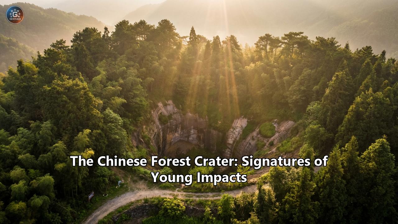
The unmasking of the Yilan Crater began far above the Earth's surface. In satellite imagery captured by instruments like the Operational Land Imager (OLI) on NASA's Landsat 8, a distinct, horseshoe-shaped depression stands out against the rolling, heavily forested hills of the Lesser Xing'an range, approximately 20 kilometers (12.5 miles) northwest of the town of Yilan.
When observed in the autumn months, the crater's unique topography is spectacularly highlighted by the changing seasons. A Landsat 8 image captured on October 8, 2021, showcased the crater's scalloped northern rim ablaze in vibrant fall foliage. This crescent-shaped ridge rises sharply from the forest floor, reaching heights of up to 150 meters (500 feet) above the interior basin.
Spanning 1.85 kilometers (1.15 miles) at its widest point, Yilan immediately captured the attention of researchers. For a terrestrial crater, its preservation is remarkably pristine—with one glaring exception. While the northern, eastern, and western sections of the rim are well-preserved and heavily vegetated, the southern third of the crater rim is entirely missing.
This missing southern wall initially raised questions about the structure's origins. Volcanic calderas, glacial cirques, and collapsed karst sinkholes can sometimes mimic the circular shape of impact craters. To prove beyond a shadow of a doubt that Quanshan was forged by a falling star, scientists had to look far beneath the forest floor for the microscopic fingerprints of a cosmic cataclysm.
Drilling into Deep Time: The Geological Smoking Gun
To investigate the true nature of the Yilan structure, a research team led by scientists from the Guangzhou Institute of Geochemistry and other prominent institutions undertook a massive drilling operation. They positioned their equipment in the exact center of the crater and bored down a staggering 438 meters (1,440 feet) into the Earth.
What they pulled up from the depths was a perfectly preserved timeline of destruction and slow geological healing.
The uppermost 110 meters (360 feet) of the drill core consisted of thick, dark lacustrine (lake) sediments. This was a crucial finding. The presence of deep lakebed deposits proved that the crater must have once been a fully enclosed, bowl-shaped basin capable of holding a massive body of standing water. This implies that the missing southern rim was not absent from the beginning; it must have remained intact for thousands of years, allowing the lake to form and quietly accumulate organic sediments on its floor, before eventually breaching due to unknown erosional or tectonic forces.
Beneath the peaceful lake sediments lay the chaotic evidence of the impact itself. The drill core revealed a 319-meter-thick unit of brecciated granite—a jagged, pulverized mash of unconsolidated rock fragments. The bedrock in this region of Heilongjiang consists of Paleozoic to Mesozoic granite complexes, specifically formed during the Early Jurassic Period approximately 200 million years ago. When the asteroid struck, it shattered this ancient, solid granite as if it were glass.
Between the depths of 218 and 237 meters in the brecciated unit, the researchers found the holy grail of impact geology: true melt products. The intense kinetic energy of the impact had instantly generated temperatures exceeding thousands of degrees Celsius, literally melting the target rock. The core samples contained vesicular glass (glass filled with tiny holes formed by escaping gas bubbles), tear-drop shaped glass fragments formed as molten rock was flung through the air and cooled mid-flight, and recrystallized granite clasts.
Furthermore, petrographic investigations under powerful microscopes revealed "shocked quartz". Quartz is a common mineral, but when subjected to the incomprehensible, instantaneous pressures of an asteroid impact, its internal crystal lattice is permanently deformed. This deformation manifests as multiple intersecting sets of microscopic lines known as Planar Deformation Features (PDFs). The researchers found precise orientations of these PDFs in the quartz grains, a signature that can only be produced by shock metamorphism from a hypervelocity impact. As a final, irrefutable piece of evidence, they discovered crystallite aggregates of coesite—a rare, ultra-high-pressure polymorph of quartz—embedded within silica glass.
The scientific verdict was unanimous and unambiguous: The Chinese Forest Crater was a genuine, high-intensity meteorite impact crater.
By the Numbers: Size, Age, and the Megafauna
With its extraterrestrial origin confirmed, the next crucial step was determining the age of the crater. Researchers extracted samples of organic charcoal and lakebed sediments from the drill core and subjected them to radiocarbon (Carbon-14) dating. The results were astonishing: the impact event occurred a mere 46,100 to 53,000 years ago, placing it firmly in the late Pleistocene epoch.
This relatively young age makes the Yilan Crater an absolute titan in the world of impact geology. Spanning 1.85 kilometers across, Yilan is officially the largest impact crater on Earth under 100,000 years old.
To put this in perspective, Yilan's closest analogue is the famous Meteor Crater (also known as Barringer Crater) in the painted deserts of Arizona. Meteor Crater also formed roughly 50,000 years ago and is one of the most recognizable impact structures in the world. However, Barringer spans only 1.2 kilometers (0.75 miles) in diameter, making the Chinese Forest Crater significantly larger and indicative of a much more energetic collision.
Advanced seismic investigations utilizing ultra-dense observation arrays and SmartSolo nodes have allowed geophysicists to build 3D velocity models of the crater's subsurface. By employing numerical modeling, scientists constrained the parameters of the impact. Whether the object was a highly dense iron meteorite or a larger, porous stony asteroid, the residual kinetic energy upon striking the Earth was roughly 1 × 10^17 Joules. The shockwave radiating through the Lesser Xing'an mountains would have been equivalent to a magnitude 5.5 earthquake, flattening the ancient forests for miles around and igniting widespread wildfires—the remnants of which were likely the very charcoal layers the scientists dated in the drill core.
At the time of the impact, the regional environment was drastically different. The late Pleistocene was the era of megafauna. Mammoths, woolly rhinos, and other massive prehistoric mammals roamed the landscapes of northeastern Asia. The sudden, violent release of energy from the Yilan impact likely had a considerable, albeit localized, effect on these populations, devastating the regional flora and fauna in a blinding flash of light and a deafening supersonic boom.
The Mystery of the Missing Rim
While the origin and age of the crater have been solved, the Yilan structure still harbors geological mysteries. Chief among them is the fate of its southern rim.
As noted by researchers, the topography features a stark contrast between the towering 150-meter-high northern crescent and the completely flattened southern boundary. The discovery of the 110-meter-thick lacustrine sediment layer proves that the crater acted as a closed basin for a significant geological period, harboring a deep lake. So, how did a mountain-sized wall of granite simply vanish?
Scientists continue to investigate this anomaly. One prominent theory involves the gradual accumulation of water over thousands of years. As the climate fluctuated, heavy precipitation and regional drainage may have overfilled the crater lake. The immense hydrostatic pressure of millions of gallons of water pressing against the fractured, brecciated rock of the rim could have eventually caused a catastrophic structural failure, leading to a massive blowout and the draining of the lake. Alternatively, glacial activity during the Last Glacial Maximum could have scoured the southern rim away, or tectonic shifts could have caused the fractured rock to slump and erode. Regardless of the exact mechanism, the missing rim provides a unique window into the post-impact evolution of crater environments, showcasing how Earth's surface aggressively reclaims and reshapes its cosmic scars.
A Renaissance of Chinese Crater Discoveries
The confirmation of the Yilan Crater acted as a catalyst, sparking a "crater rush" among geologists in China. Armed with new satellite imaging techniques, advanced subsurface seismic mapping, and a deeper understanding of localized shock metamorphism, scientists began identifying new impact structures across the country at an unprecedented rate.
Shortly after Yilan's confirmation, an incredible discovery was made in the neighboring Jilin province: the Baijifeng Crater. Unlike Yilan, which sits in a forested valley, the Baijifeng Crater is a mountaintop anomaly. It is the world's first confirmed alpine impact crater, situated entirely on the summit of Baijifeng Mountain at an elevation of over 1,300 meters. Spanning 1,400 meters (4,600 feet) in diameter, the crater is shaped like a giant ice bucket or funnel sitting precariously between two peaks. For generations, locals marveled at the "heavenly stones"—massive fields of gray-white sandstone and Jurassic granite fragments that cascaded down the mountain slopes like stone waterfalls. It was long a mystery until researchers found planar deformation features (PDFs) in the quartz samples, confirming that an asteroid collision had literally blown the top off the mountain tens of thousands of years ago, shaping the modern peaks of "Pre Baiji" and "Post Baiji".
The discoveries did not stop in the north. Deep in the tropical, mountainous terrain of southern China's Guangdong province, researchers identified the Jinlin crater near the city of Zhaoqing. Measuring about 900 meters (2,952 feet) in diameter, the Jinlin crater is the first confirmed impact structure in southern China—a region that accounts for a quarter of the nation's landmass. Fascinatingly, the Jinlin impact is exceptionally young, occurring around 10,000 years ago during the dawn of early human civilization. Caused by a 30-meter-wide extraterrestrial object, the impact released energy estimated at 600,000 tonnes of TNT—equivalent to the explosive power of 40 Hiroshima-sized atomic bombs.
Together with the older Xiuyan crater and the newly identified Hailin crater, China's verified impact structures have grown to five, painting a vivid picture of a landscape routinely battered by the cosmos.
The Ecosystem Reborn: The Lesser Khingan Mountains Today
Perhaps the most poetic aspect of the Yilan Crater is its modern role as a sanctuary for biodiversity. The violent energy that excavated Quanshan is long gone, replaced by the quiet, persistent forces of life.
The Lesser Khingan (Xing'an) mountain range is one of northern China's most critical natural forest barriers, separating the Amur (Heilongjiang) River valley from the Nenjiang River valley. The crater and its surrounding topography are heavily forested, dominated by ancient, towering Korean pines (also known as red pines). These magnificent trees, often referred to as the "kings of the forest," are an endemic species to Northeast Asia and play a vital role in carbon sequestration and climate regulation.
Within this lush, 97% forest-covered ecosystem, life thrives in the very depression carved by an asteroid. The deep soils formed from the ancient lakebed sediments inside the Yilan crater provide rich nutrients for over 600 plant species, including Amur linden, Manchurian ash, and wild soybean.
This dense taiga environment is a critical habitat for some of Asia's most majestic and endangered wildlife. Extensive conservation efforts and a strict ban on commercial logging in the Khingan Mountains have allowed nature to reclaim the region. Today, the forests surrounding the Yilan crater are home to the Eurasian lynx, wolverines, sable, Siberian musk deer, and red deer. Most remarkably, the region serves as an expanding territory for the critically endangered Siberian tiger, acting as an ecological corridor where these apex predators can roam through the ancient blast zone undisturbed.
Conclusion: Whispers of the Cosmos in the Forest
The Chinese Forest Crater is far more than just a geological anomaly; it is a profound monument to the dynamic relationship between Earth and the wider universe. Hidden for millennia beneath a canopy of towering pines, the Yilan Crater serves as a stark reminder of the immense, sudden violence that space can inflict upon our world.
Yet, as visitors stand on the crescent-shaped ridge of Quanshan and look out over the vibrant autumn foliage, the overriding feeling is not one of destruction, but of profound resilience. The 438-meter drill core pulled from the crater's heart tells a complete story: from ancient Jurassic granite, to the blinding flash of a hypervelocity impact 50,000 years ago, to the slow, quiet accumulation of a deep crater lake, and finally, to the thriving, vibrant forest ecosystem that exists today.
As scientists continue to study Yilan, Baijifeng, and the other newly discovered impact structures across China, they are doing more than just cataloging the scars of the past. They are calculating the residual kinetic energies, modeling the planetary defenses of the future, and unearthing the long-hidden secrets of how our living, breathing planet responds to the touch of the cosmos. In the heart of the Lesser Khingan Mountains, the universe left a fiery footprint, and the Earth, in its infinite patience, grew a forest over it.
Reference:
- https://blog.smartsolo.com/case-studies/the-secrets-of-yilan-crater-a-seismic-investigation-with-smartsolo-nodes/
- https://www.researchgate.net/publication/390889175_Subsurface_structure_and_impact_process_of_Yilan_Crater_northeastern_China
- https://www.scmp.com/news/china/science/article/3330000/crater-suggests-asteroid-hit-guangdong-10000-years-ago-blast-40-atomic-bombs
- https://www.researchgate.net/publication/7975386_Planetary_science_Meteor_Crater_formed_by_low-velocity_impact
- http://m.ysfrit.com/news/china-discovered-the-world-s-first-alpine-crat-71087417.html
- https://www.scmp.com/news/china/science/article/3234240/worlds-first-confirmed-mountaintop-impact-crater-identified-ne-china
- https://en.wikipedia.org/wiki/Lesser_Khingan
- https://english.news.cn/20240331/aacd5b806b2c440faa992216cfbb56f3/c.html
- https://english.cas.cn/print/index.shtml?docurl=https://english.cas.cn/special-reports/5thwcbr/wcbrg/202601/t20260105_1145196.shtml
- https://pubmed.ncbi.nlm.nih.gov/38903147/