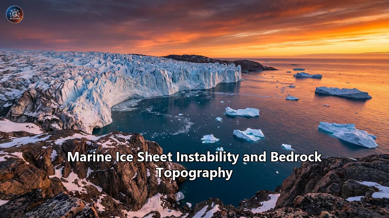
Beneath the desolate, howling surface of the Antarctic and Greenland ice sheets lies a hidden, alien world—a submerged landscape of deep canyons, towering subglacial mountains, and sweeping plains. For over a century, scientists looking to predict the future of global sea levels focused primarily on the sky, measuring air temperatures and atmospheric greenhouse gases. But over the last few decades, a quiet revolution has taken place in glaciology. We now know that the ultimate fate of our coastlines is not just written in the warming air above, but etched into the very shape of the bedrock buried miles beneath the ice.
This realization hinges on a profound and terrifying geophysical concept: Marine Ice Sheet Instability (MISI). It is a mechanism of runaway, self-sustaining ice loss driven by the interplay between warming oceans and the hidden topographical slopes of the continent. Alongside its highly debated cousin, Marine Ice Cliff Instability (MICI), MISI represents one of the most critical tipping points in the Earth’s climate system.
To understand why glaciers the size of Great Britain are teetering on the edge of collapse, we must take a journey to the grounding line—the dark, pressurized frontier where ice, ocean, and bedrock collide.
The Anatomy of a Marine Ice Sheet
Not all ice sheets are created equal. A terrestrial ice sheet, like much of East Antarctica, rests on bedrock that is situated above sea level. If these glaciers melt, they do so largely from the top down, driven by warming air temperatures.
A marine ice sheet, however, is a different beast entirely. Vast swathes of the West Antarctic Ice Sheet (WAIS) rest on bedrock that is plunged hundreds, and in some places thousands, of meters below sea level. The ice is so unimaginably thick—often spanning over a mile deep—that its sheer weight displaces the ocean water, allowing the ice to sit firmly on the submerged ocean floor.
The architecture of a marine ice sheet can be divided into three distinct zones:
- The Grounded Ice: The colossal interior mass of the ice sheet that rests directly on the continental bedrock.
- The Ice Shelf: As the ice slowly flows outward from the center of the continent toward the coast, it eventually detaches from the seafloor and begins to float. This floating extension is the ice shelf. Ice shelves act like structural buttresses, or corks in a champagne bottle. They provide physical resistance, pushing back against the immense weight of the grounded ice behind them, slowing its march into the sea.
- The Grounding Line: The pivotal boundary where the ice detaches from the bedrock and begins to float. It is the transition zone between grounded ice and the ice shelf.
The grounding line is arguably the most important battleground in global climate science. It is not a static marker; it is highly dynamic. If the ice shelf thins or melts due to warming ocean currents, it loses its buttressing power. The grounding line is then forced to retreat inland. But whether that retreat is a slow, gradual crawl or a catastrophic, unstoppable collapse depends almost entirely on the shape of the bedrock below.
The Hidden Landscape: Prograde vs. Retrograde Bedrock Topography
To comprehend Marine Ice Sheet Instability, one must understand the geological canvas upon which it plays out. The stability of a grounding line is governed by the slope of the subglacial topography.
Prograde Slopes (Stabilizing)Imagine a beach that gently slopes upward as you walk inland away from the water. This is a prograde slope. If an ice sheet is resting on a prograde slope, a warming ocean might melt the front of the ice, causing the grounding line to retreat slightly inland. However, as it retreats, it moves onto shallower, higher ground. Because the ice at the new grounding line is in shallower water, the cross-section of ice exposed to the ocean is smaller. The ice flow slows down, and the system easily establishes a new, stable equilibrium. Prograde slopes act as natural brakes.
Retrograde Slopes (Destabilizing)Now, imagine a landscape that behaves like a deep bowl. As you move inland from the coast, the bedrock doesn't rise; it dips deeper and deeper below sea level. This is a retrograde slope, or a reverse-bed gradient. Much of West Antarctica, pressed down over millions of years by the immense weight of the ice, is shaped exactly like this.
When a grounding line is forced to retreat down a retrograde slope, a nightmare scenario in glaciological physics is triggered.
- As the ocean melts the ice shelf, the grounding line moves inland, down the slope into deeper water.
- Because the water is deeper, a taller, thicker column of ice is suddenly forced to float.
- According to the laws of glaciological physics, the amount of ice flowing across the grounding line (the ice flux) is highly sensitive to the thickness of the ice at that exact point. Thicker ice flows much faster than thinner ice.
- Because the retreat has exposed thicker ice to the ocean, the glacier speeds up, dumping more ice into the sea.
- This acceleration thins the grounded ice just behind the line, causing it to lift off the bedrock, forcing the grounding line even further inland, into even deeper water.
This is the essence of Marine Ice Sheet Instability (MISI): a self-sustaining, positive feedback loop. Once the grounding line retreats past a certain high point (a subglacial ridge) and begins slipping down a retrograde slope, the process becomes virtually irreversible. Even if ocean temperatures were to miraculously cool back down, the physics of the deepening bedrock would ensure that the glacier continues to hemorrhage ice into the sea until it finds a new shallow ridge, which may be hundreds of miles inland.
A 2019 mathematical analysis using stochastic perturbation theory demonstrated that MISI drastically amplifies the uncertainty in our sea-level projections, heavily skewing outcomes toward worst-case scenarios. The reverse-sloping bedrock turns gradual climate warming into a non-linear planetary emergency.
The Doomsday Glacier: Thwaites on the Brink
There is no place on Earth where the threat of MISI is more immediate or consequential than the Thwaites Glacier in the Amundsen Sea sector of West Antarctica.
Roughly the size of Great Britain or the US state of Florida, Thwaites is a colossal river of ice currently losing approximately 50 billion metric tons of mass every single year, accounting for around 4% of all global sea-level rise. If Thwaites were to melt completely, it would raise global sea levels by roughly 65 centimeters (over 2 feet). However, Thwaites is also considered the keystone holding back the rest of the West Antarctic Ice Sheet. If Thwaites collapses, it could trigger a regional destabilization leading to over 3.3 meters (11 feet) of sea-level rise—enough to drown coastal cities from Miami to Jakarta.
In the early 2020s, a joint UK-US initiative called the International Thwaites Glacier Collaboration (ITGC) deployed satellites, underwater robots (like the torpedo-shaped Icefin), and hot-water drills to probe the glacier's vulnerabilities. The discoveries made between 2023 and 2026 have fundamentally reshaped our understanding of glacial demise.
The Subglacial Trenches and El Niño
Researchers mapping the bedrock topography of Thwaites discovered a labyrinth of deep trenches—some up to 800 meters deep—carved into the seafloor beneath the ice. These channels act as superhighways for Circumpolar Deep Water (CDW), a relatively warm, salty ocean current. Shifting wind patterns, exacerbated by climate change and intense El Niño events, have weakened the Pacific trade winds, allowing this warm water to well up onto the continental shelf and penetrate deep into the belly of the glacier.
The 2024 Shock: Tidal Pumping
For decades, scientists modeled grounding lines as static boundaries. But in 2024, utilizing high-resolution synthetic aperture radar (SAR) from the ICEYE satellite constellation, glaciologists made a staggering observation. The immense surface of Thwaites Glacier, resting over 1,000 meters thick, was rising and falling by tens of centimeters twice a day, perfectly in sync with the ocean tides.
Eric Rignot, a lead researcher from NASA's Jet Propulsion Laboratory, described the zone where the ice rests on the seafloor as the "Achilles heel of the glaciers". The tides were acting like a giant, mechanical lung. As the tide rose, it lifted the entire glacier, pumping warm, pressurized seawater as far as 60 kilometers (37 miles) beneath the grounded ice. This "vigorous melting" from tidal pumping lubricates the bedrock, degrades the ice from the bottom up, and vastly accelerates the onset of MISI. The volume of water flowing from Thwaites into the ocean has more than doubled since the 1990s, driven by these hidden, pressurized seawater intrusions.
Disintegration of the Ice Shelf
The floating ice shelf that historically acted to buttress Thwaites is currently shattering. In 2019, the shelf suffered massive cracks, leading to the calving of huge icebergs. By late 2024, comprehensive studies indicated that the structural integrity of the Thwaites ice shelf was in its final stages of failure, with a complete disintegration of the floating portion expected within the decade. Once that buttress is gone, the grounded ice will be fully exposed to the retrograde slope of the bedrock, potentially locking in the MISI feedback loop for centuries to come.
Marine Ice Cliff Instability (MICI): The Debate Over Sudden Collapse
As if MISI were not concerning enough, scientists have recently wrestled with a secondary, even more violent theoretical mechanism known as Marine Ice Cliff Instability (MICI).
Introduced into prominent climate models by researchers Rob DeConto and David Pollard in 2016, MICI operates on the limits of materials science. If an ice shelf collapses completely, it doesn't just expose a gentle slope of ice to the ocean; it exposes a vertical cliff face. Ice, despite its apparent rigidity, is a weak material. The MICI hypothesis posits that an ice cliff towering more than 100 meters above the water line simply cannot support its own weight. The stresses at the base of the cliff would exceed the shear strength of the ice, causing the cliff to violently fracture and collapse into the sea.
Because the glacier rests on a retrograde slope, as the cliff face collapses, it exposes an even taller, thicker cliff behind it. This triggers a runaway, domino-like effect of continuous structural failure, causing the ice sheet to disintegrate at terrifying speeds.
The inclusion of MICI in some predictive models led the Intergovernmental Panel on Climate Change (IPCC) to introduce a "low-likelihood, high-impact" storyline in its Sixth Assessment Report. This extreme scenario projected that Antarctica could contribute twice as much to sea-level rise by 2100 than previously expected, and up to 15 meters by 2300.
However, the scientific community remains fiercely debated on the true immediacy of MICI. Recent high-resolution modeling, including a landmark 2024 study published in Science Advances led by Dartmouth researchers, suggests that the apocalypse of crumbling ice cliffs might not happen as rapidly as once feared.
When researchers implemented advanced, physically-motivated models that accounted for how ice flows under pressure, they found a natural stabilizing effect. When an ice shelf collapses, the immense pressure of the grounded ice causes the glacier to surge forward and flow faster. This rapid forward flow physically thins out the ice near the margin. As the ice stretches and thins, the height of the terminal cliff drops below the critical 100-meter threshold, effectively stabilizing the cliff face and preventing the rapid, domino-style collapse.
Jeremy Bassis, a glaciologist from the University of Michigan, ran simulations showing that as massive ice cliffs shatter, the icy rubble and debris accumulating at the base of the cliff act as a temporary buttress, slowing the rate of failure.
Does this mean the coastal cities of the world are safe? Absolutely not. As the authors of the Dartmouth study emphasized, while the immediate structural collapse (MICI) might be slower to trigger than the most extreme IPCC models suggested, the underlying threat of Marine Ice Sheet Instability (MISI) remains fully active. Thwaites is still retreating, it is still losing mass, and the bedrock is still sloping downwards into the abyss. The delay of MICI only buys us a narrow window of time, not a pardon.
Beyond West Antarctica: The Global Cryosphere Threat
While the Amundsen Sea Embayment (hosting Thwaites and the neighboring Pine Island Glacier) is the poster child for MISI, retrograde topography is a hidden danger globally.
East Antarctica: The Sleeping Giant
For decades, the East Antarctic Ice Sheet (EAIS) was considered the stable anchor of the global climate. Holding the vast majority of the world's fresh water, it sits largely on high continental bedrock. However, advanced radar mapping (like the BEDMAP2 database) has revealed that massive sectors of the EAIS, such as the Wilkes Subglacial Basin, are actually marine-based and rest on deeply retrograde slopes.
If warm ocean currents infiltrate the East Antarctic basins, they could trigger MISI in regions previously thought to be invincible. Findings from the ITGC explicitly warn that immediate decarbonization is the only way to prevent the initiation of unstable retreat in the marine-based sectors of East Antarctica.
Greenland's Deep Fjords
In the Northern Hemisphere, the Greenland Ice Sheet presents a slightly different topography, characterized by deep, narrow fjords rather than broad marine basins. Many of Greenland’s outlet glaciers, such as Jakobshavn Isbræ, rest on reverse-sloping beds within these fjords. As warm Atlantic water pushes into these fjords, it melts the glaciers from below, forcing rapid retreat. While Greenland’s total sea-level equivalent is lower than Antarctica's (roughly 7 meters), its current rate of mass loss is incredibly steep, driven by a combination of surface melting and marine instability at the deep grounding lines.
The Physics of Water and Bedrock: Subglacial Hydrology
The relationship between ice and bedrock is mediated by an invisible layer of water. The immense pressure of the ice sheet miles overhead actually lowers the melting point of ice at the base. Combined with geothermal heat rising from the Earth's crust, this creates a vast subglacial hydrological system—a dark network of lakes, rivers, and swamps hidden entirely from the sun.
This basal water acts as a high-pressure lubricant. Where the bedrock is rough and dry, the ice flow is slow, held back by basal friction. But when subglacial water pools on retrograde slopes, the glacier essentially hydroplanes.
Furthermore, as the grounding line retreats down a retrograde slope, warm ocean water can spill over high subglacial ridges, carving out vast cavities beneath the ice. These cavities allow ocean water to mix with fresh subglacial meltwater, creating turbulent eddies that further scour the underside of the glacier, rapidly dissolving the ice from the bottom up.
The Rebound Effect: Glacial Isostatic Adjustment
Is there any natural force that can halt MISI once it starts? There is one geological phenomenon that offers a glimmer of hope: Glacial Isostatic Adjustment (GIA), or bedrock rebound.
The Earth's crust is not rigid; it floats on the viscous mantle below. The monumental weight of an ice sheet pushes the bedrock down into the mantle. If an ice sheet melts rapidly due to MISI, that immense weight is removed. Over time, the bedrock will actually bounce back, rising upward.
In theory, if the bedrock beneath a retreating grounding line rebounds fast enough, it could shallow the water, shift the topography from a retrograde to a prograde slope, and naturally halt the instability. However, the viscosity of the Earth's mantle varies globally. While some areas of West Antarctica have relatively "runny" mantles that allow for fast rebound, scientists generally agree that this geological bounce-back operates on timescales of centuries to millennia—likely far too slow to save coastal communities from the rapid inundation expected over the next hundred years.
Desperate Measures: Geoengineering the Seafloor
The horrifying certainty of bedrock topography has forced some scientists to think beyond emissions reductions and consider active planetary intervention. If the ocean is the weapon and the retrograde slope is the vulnerability, can we build a shield?
In 2024 and 2025, glaciologists John Moore and Michael Wolovick gained significant traction for a radical geoengineering proposal: building an artificial barrier on the seafloor to protect the Doomsday Glacier.
The concept does not involve building a solid concrete dam, which would be destroyed by the crushing force of icebergs. Instead, they propose anchoring a massive, flexible, buoyant "sea curtain" to the bedrock of the Amundsen Sea. This 100-kilometer-long curtain would rise from the ocean floor, specifically designed to block the deep, warm Circumpolar Deep Water from flowing into the subglacial trenches beneath Thwaites, while allowing cold, fresh surface water to flow over the top.
By starving the grounding line of its thermal fuel, the sea curtain could theoretically halt the basal melting, allowing the ice shelf to thicken, reground on the seabed, and halt the MISI feedback loop.
While the engineering challenges are bordering on the impossible—operating deep underwater in bone-chilling, iceberg-choked, tempestuous seas—the cost of such a mega-project (estimated in the tens of billions) pales in comparison to the tens of trillions of dollars in economic damages that a 3-meter global sea-level rise would inflict on global real estate, infrastructure, and agriculture. Still, critics warn that geoengineering the Antarctic is fraught with ecological risks, and it fundamentally distracts from the root cause of the crisis: the unabated burning of fossil fuels.
The Global Implications of Bedrock
It is a profound paradox that the daily lives of billions of people in the 21st century will be dictated by the shape of submerged rocks that human eyes have never directly seen.
The consequences of Marine Ice Sheet Instability will not be contained to the polar circles. A retreat driven by retrograde topography will fundamentally reshape the global map.
- Coastal Inundation: Current trajectories, amplified by MISI, suggest sea-level rise could easily exceed 1 to 1.5 meters by 2100 if tipping points are crossed. Cities like Miami, New York, Mumbai, Shanghai, and Dhaka face existential threats. Low-lying island nations, such as the Maldives and Tuvalu, will be wiped from the map entirely.
- Ocean Circulation Disruption: The catastrophic influx of hundreds of billions of tons of cold, fresh meltwater into the Southern Ocean disrupts the global thermohaline circulation. This alters weather patterns globally, shifting rainfall belts, intensifying tropical cyclones, and creating more extreme, unpredictable agricultural seasons.
- Economic Cascades: The slow-motion collapse of global coastlines will trigger an unprecedented migration crisis, as hundreds of millions of people are forced inland. The abandonment of coastal real estate will lead to systemic financial shocks, as mortgages go underwater—both literally and financially.
A Closing Reality
The study of Marine Ice Sheet Instability and Bedrock Topography forces us to confront the non-linear nature of Earth's climate. We are used to thinking of climate change as a thermostat: turn the heat up, things get worse; turn the heat down, things get better.
MISI teaches us that the Earth does not have a thermostat; it has trapdoors.
The retrograde slopes of West Antarctica are a geological trapdoor. We are currently applying the immense thermal pressure of global warming to the hinge. Our sophisticated satellite networks, our robotic submarines diving into the dark crevices of Thwaites, and our supercomputer models all tell us the same story: the ice is thinning, the ocean is warming, and the grounding line is slipping down the slope.
While the debate over the structural collapse of towering ice cliffs (MICI) may adjust the timeline slightly, the underlying physics of MISI remain an undisputed, looming threat. Immediate, sustained decarbonization to keep global temperatures within the 1.5°C Paris Agreement limit is the only scientifically sound method to prevent the ice from fully crossing the threshold into irreversible collapse.
The topography is fixed. The bedrock will not move. The only variable left in the equation is us.
Reference:
- https://climate.sustainability-directory.com/term/marine-ice-sheet-instability/
- https://pmc.ncbi.nlm.nih.gov/articles/PMC11338217/
- https://www.antarcticglaciers.org/antarctica-2/west-antarctic-ice-sheet-2/marine-ice-sheets/
- https://courier.unesco.org/en/articles/glaciers-under-close-surveillance
- https://www.pnas.org/doi/10.1073/pnas.1904822116
- https://www.carbonbrief.org/guest-post-the-challenges-in-projecting-future-global-sea-levels/
- https://www.researchgate.net/publication/334326128_Marine_ice_sheet_instability_amplifies_and_skews_uncertainty_in_projections_of_future_sea-level_rise
- https://thwaitesglacier.org/
- https://noco2.com.au/blog/2024-latest-research-on-thwaites-glacier-collapse/
- https://news.mongabay.com/2025/09/scientists-weigh-giant-sea-curtain-to-shield-doomsday-glacier-from-melting/
- https://polarjournal.net/thwaites-countdown-to-disintegration/
- https://www.sciencenews.org/article/climate-marine-ice-cliffs-sheets-collapse-not-inevitable-sea-level
- https://home.dartmouth.edu/news/2024/08/study-finds-highest-prediction-sea-level-rise-unlikely
- https://iccinet.org/ice-cliff-collapse-may-not-occur-so-rapidly-in-the-near-term-but-risks-of-major-sea-level-rise-remain/