The Unseen World: How Forensic Oceanography Resurrects Maritime Ghosts
The ocean is a vast and unforgiving expanse, a realm of immense power and profound mystery. For millennia, it has been the cradle of trade, exploration, and conflict, but it is also a graveyard. Beneath its waves lie the silent tombs of countless vessels, from humble fishing boats to mighty warships, each with a story to tell. For centuries, these stories were lost to the crushing pressure and the dark, cold abyss. But today, a new breed of explorer is venturing into this submerged world, armed not with the sextants and compasses of old, but with an arsenal of cutting-edge technology. This is the world of forensic oceanography, a discipline that combines the precision of science with the thrill of discovery to reconstruct the final moments of shipwrecks and bring their hidden narratives to light.
Forensic oceanography, in its broadest sense, is the application of scientific and engineering principles to understand events that occur on or in the ocean. This can range from investigating the cause of a modern maritime accident to painstakingly reassembling the history of an ancient vessel from its scattered remains on the seafloor. It is a field where oceanographers, archaeologists, engineers, and historians converge, using technology to answer questions that have long been thought unanswerable: Why did a ship sink? What were the conditions like in its final moments? And what can its remains tell us about the people who built it, sailed it, and, in some tragic cases, perished with it?
This is not merely about finding and mapping sunken ships; it is about a virtual resurrection. It's about using sound waves to see through the murky depths, deploying robotic submarines to explore where no human can go, and creating digital models so detailed that we can virtually swim through the corridors of a long-lost vessel. This journey into the abyss is more than just a technological marvel; it is a profound act of remembrance, a way of honoring the lives and legacies that are intertwined with these underwater time capsules.
The Digital Toolbox: Unveiling the Secrets of the Deep
The ability to reconstruct shipwrecks with astonishing accuracy is a testament to the rapid advancements in underwater technology. What was once the realm of speculation and grainy sonar images has been transformed by a suite of sophisticated tools that allow us to see, map, and analyze the submerged world in unprecedented detail. These technologies are the eyes and hands of the forensic oceanographer, enabling them to piece together the puzzle of a shipwreck from the ocean floor.
Seeing with Sound: The Evolution of Sonar
The first step in any shipwreck investigation is finding the wreck itself. For this, sonar (Sound Navigation and Ranging) is the indispensable tool of the trade. By sending out pulses of sound and measuring the echoes that bounce back, sonar systems can create detailed maps of the seafloor.
- Side-scan sonar is often the first tool deployed in a search. Towed behind a surface vessel in a device called a "towfish," it sends out fans of acoustic energy to either side, creating a detailed image of the seabed. This technique is excellent for covering large areas and identifying anomalies that could be a shipwreck.
- Multibeam echosounders take this a step further by emitting sound waves in a fan shape, allowing for the collection of high-resolution bathymetric data. This data can be used to create three-dimensional maps of the shipwreck and the surrounding terrain, revealing the vessel's orientation and the extent of the debris field.
- Synthetic Aperture Sonar (SAS) represents a quantum leap in sonar technology. By combining multiple acoustic pings, SAS can create images with a resolution up to ten times higher than conventional sonar. This allows for the identification of fine details, such as the individual planks of a wooden ship or even objects as small as a lost piece of rigging. When mounted on an autonomous underwater vehicle (AUV), SAS can be used for long-term monitoring of shipwrecks, detecting changes in their condition over time. This level of detail is invaluable for understanding the process of a shipwreck's decay and for planning any potential conservation efforts.
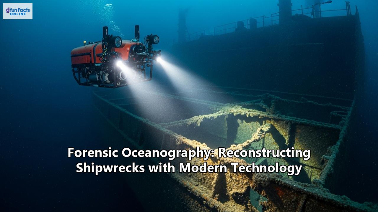
The Robotic Explorers: AUVs and ROVs
Once a potential shipwreck has been located, the next step is to get a closer look. This is where robotic vehicles come into play, acting as the remote eyes and hands of the investigators.
- Autonomous Underwater Vehicles (AUVs) are untethered, pre-programmed robots that can survey large areas of the seafloor with remarkable efficiency. They are often equipped with a variety of sensors, including sonar, magnetometers, and high-resolution cameras. AUVs are particularly useful for the initial mapping of a wreck site, providing a comprehensive overview that can be used to plan further investigations. Their ability to operate without a tether to a surface vessel makes them highly versatile and cost-effective, revolutionizing the speed and scale of underwater exploration.
- Remotely Operated Vehicles (ROVs), in contrast, are tethered to a surface vessel, where a pilot controls their movements in real-time. This tether provides a constant stream of power and data, allowing for more detailed and interactive exploration. ROVs are often equipped with high-definition cameras, powerful lights, and robotic arms that can be used to collect samples or move debris. They are essential for the close-up inspection of a shipwreck, allowing researchers to "fly" through the wreckage and document its every detail.
The use of both AUVs and ROVs in tandem has become a standard practice in marine archaeology. The AUV provides the wide-area survey, and the ROV conducts the detailed, up-close investigation, a combination that has proven highly effective in numerous shipwreck explorations.
Creating Digital Ghosts: 3D Photogrammetry and LiDAR
Perhaps the most visually stunning advancement in forensic oceanography is the ability to create highly detailed, three-dimensional models of shipwrecks. This is achieved through two primary techniques: photogrammetry and LiDAR.
- 3D Photogrammetry is the art and science of making measurements from photographs. In an underwater setting, this involves taking thousands of overlapping digital images of a shipwreck from various angles. These images are then fed into specialized software that identifies common points between them and stitches them together to create a photorealistic 3D model. This technique allows archaeologists to create incredibly accurate and detailed site plans in a fraction of the time it would take using traditional methods. The resulting "digital twin" of the shipwreck can be studied from any angle, allowing researchers to analyze the wreck's structure, identify artifacts, and even plan virtual excavations.
- LiDAR (Light Detection and Ranging) works on a similar principle to sonar but uses laser pulses instead of sound waves. Bathymetric LiDAR systems use a green laser that can penetrate the water column to map the seafloor with incredible precision. While its effectiveness can be limited by water clarity and depth, LiDAR is an excellent tool for mapping shipwrecks in shallower coastal waters. When combined with data from other sensors, LiDAR can contribute to the creation of comprehensive 3D models of wreck sites.
Seeing the Unseen: Hyperspectral Imaging and Other Sensors
Beyond visual and acoustic imaging, forensic oceanographers also employ a range of other sensors to extract as much information as possible from a shipwreck site.
- Underwater Hyperspectral Imaging (UHI) is an emerging technology that analyzes the entire spectrum of light reflected from an object. Different materials have unique spectral signatures, and UHI can be used to identify the composition of artifacts on the seafloor, such as different types of wood, metal, or ceramics. This can provide crucial clues about a ship's construction and cargo without the need for physical sampling.
- Magnetometers are used to detect variations in the Earth's magnetic field caused by large iron objects. They are particularly useful for locating shipwrecks with iron hulls or cannons, even if they are buried beneath sediment.
The integration of data from all these technologies is what makes forensic oceanography so powerful. By combining the broad-area mapping of sonar with the close-up detail of ROVs and the photorealistic models of photogrammetry, researchers can create a holistic and multi-layered reconstruction of a shipwreck and its final moments.
Case Files from the Abyss: Reconstructing History's Most Famous Shipwrecks
The true power of forensic oceanography is best understood through its application in the field. By examining some of the most famous shipwreck investigations, we can see how these modern technologies have been used to answer long-standing questions and rewrite our understanding of maritime history.
RMS Titanic: The Digital Resurrection of a Legend
The sinking of the RMS Titanic in 1912 is arguably the most famous maritime disaster in history. For decades, the story of its demise was told through the accounts of survivors and the findings of the original inquiries. But it wasn't until the wreck was discovered in 1985 that the ship itself began to reveal its secrets.
The initial discovery was made using the towed imaging vehicle Argo, which captured the first haunting images of the ship in 73 years. The following year, the human-occupied submersible Alvin and the ROV Jason Jr. were used to explore the wreck in more detail. These early expeditions provided a wealth of information, but it is the more recent use of advanced technology that has truly revolutionized our understanding of the Titanic's final moments.
In recent years, a deep-sea investigation company called Magellan has created the most detailed digital reconstruction of the Titanic ever produced. Using robots to survey the wreck, they collected over 715,000 photos and 4K video footage, which were then used to create a stunningly detailed 3D model of the ship and the surrounding debris field.
This "digital twin" of the Titanic has allowed researchers to study the wreck in unprecedented detail, leading to new insights into how the ship broke apart. By digitally reassembling pieces of the hull, they have been able to confirm that the ship did not split cleanly in two but was "violently torn" apart. The 3D model has also allowed them to identify and analyze individual artifacts in the debris field, connecting some of them to their original owners and providing a poignant link to the human tragedy of the sinking.
The Antikythera Wreck: Uncovering an Ancient Technological Marvel
Discovered by sponge divers in 1900, the Antikythera wreck, dating from the 1st century BC, is one of the most important archaeological finds in history. Its most famous artifact is the Antikythera Mechanism, a complex geared device that is considered the world's oldest known analog computer.
For many years, the wreck was difficult to explore due to its depth, which is too deep for conventional scuba diving but too shallow for larger submersibles. However, recent expeditions have employed a range of modern technologies to overcome these challenges. Technical divers using mixed-gas rebreathers have been able to spend more time on the wreck, while ROVs have been used for real-time monitoring and documentation.
These expeditions have resulted in the creation of detailed 3D digital models of the wreck site, which have allowed archaeologists to map the distribution of artifacts and plan further excavations. The use of advanced technology has also led to the discovery of new artifacts, including marble statues and even human remains, which could provide new insights into the lives of the people who sailed on this ancient vessel.
The Sinking of the Lusitania: A Forensic Analysis of a Wartime Tragedy
The sinking of the British passenger liner RMS Lusitania by a German U-boat in 1915 was a pivotal event in World War I, contributing to the United States' eventual entry into the conflict. For decades, there has been controversy surrounding the sinking, particularly the cause of a second explosion that followed the torpedo strike and caused the ship to sink in just 18 minutes.
Recent forensic analysis of the wreck, combining historical documents with data from expeditions to the site, has shed new light on this mystery. By studying the location of the torpedo impact and the damage to the ship, investigators have been able to develop a more accurate picture of what happened. While Germany claimed the second explosion was caused by munitions the ship was secretly carrying, some modern analyses suggest that a coal-dust explosion in one of the ship's bunkers was a more likely cause.
The exploration of the Lusitania wreck has been aided by the use of ROVs, which have allowed researchers to explore the shattered remains of the vessel in detail. The forensic analysis of the Lusitania is a prime example of how modern technology can be used to re-examine historical events and challenge long-held assumptions.
The USS Arizona: Monitoring a Sacred Memorial
The USS Arizona, sunk during the attack on Pearl Harbor in 1941, is both a shipwreck and a sacred war memorial. The investigation and monitoring of the Arizona is a delicate balance between scientific research and respectful preservation.
A variety of technologies have been used to study the wreck without disturbing it. Divers conduct visual inspections and take precise measurements, while infrared theodolites are used for accurate underwater surveying. Extensive photographic documentation is used to create detailed 3D models of the ship's structure using photogrammetry.
Multibeam sonar is used to map the wreck and the surrounding seafloor, while small ROVs are deployed to explore the ship's interior, collecting data on water quality and the rate of corrosion. All of this data is fed into complex computer models that can predict how the wreck will deteriorate over time, helping the National Park Service to manage the site and protect it for future generations.
The Analytical Engine: From Data to Understanding
The vast amounts of data collected by these advanced technologies are only the first step in the process of forensic oceanography. The real challenge lies in integrating and interpreting this data to reconstruct the sequence of events that led to a shipwreck and to understand its cause.
Causal Models in Marine Accident Investigation
In the investigation of modern maritime accidents, investigators often use causal models to understand the complex interplay of factors that can lead to a disaster. These models go beyond a simple chain of events and consider the broader context, including human factors, technical failures, and environmental conditions.
The Human Factor Analysis and Classification System (HFACS), for example, is a framework that is often used to analyze the role of human error in accidents. By systematically identifying the different levels of failure, from unsafe acts by the crew to organizational influences, investigators can develop a more comprehensive understanding of why an accident occurred.
Similarly, systems-theoretic accident models, such as the Causal Analysis based on Systems Theory (CAST), are used to identify systemic issues that may have contributed to an accident. These models focus on failures in the feedback and control loops within a system, providing a more holistic view of accident causation.
While these models are most commonly used in the investigation of modern accidents, the underlying principles of systematic analysis and the integration of multiple data sources are also applicable to the study of historical shipwrecks.
Data Integration and Visualization
The power of forensic oceanography lies in its ability to bring together disparate datasets into a single, coherent narrative. This requires sophisticated data management and visualization tools that can integrate information from sonar, ROVs, photogrammetry, and other sensors.
Geographic Information Systems (GIS) are often used to create multi-layered maps of a shipwreck site, combining bathymetric data with the locations of artifacts and the tracks of ROV dives. This allows researchers to see the spatial relationships between different pieces of evidence and to identify patterns that might not be apparent from a single data source.
3D visualization software is then used to create the detailed models of the shipwreck, which can be annotated with information from other sources. These models serve as a virtual laboratory, allowing researchers to test hypotheses about how the ship sank and how it has changed over time.
A New Frontier: Forensic Oceanography and Human Rights
While much of the focus of forensic oceanography has been on historical shipwrecks, the same principles of investigation and reconstruction are now being applied to a more contemporary and urgent issue: the deaths of migrants at sea. A project called "Forensic Oceanography," founded by researchers Charles Heller and Lorenzo Pezzani, uses a variety of technologies to investigate the circumstances surrounding the deaths of migrants in the Mediterranean Sea.
By combining satellite imagery, vessel tracking data, geospatial mapping, and drift models with the testimonies of survivors, they are able to reconstruct the events that lead to these tragedies and to hold authorities accountable for their actions, or lack thereof. Their work has been used in legal cases and human rights reports to challenge the policies and practices that have turned the Mediterranean into a deadly frontier.
This application of forensic techniques highlights the evolving nature of the field. It demonstrates that the same tools that can be used to uncover the secrets of ancient history can also be used to shed light on the pressing injustices of our time. It is a powerful reminder that the ocean is not just a repository of the past but also a stage for the unfolding dramas of the present.
The Law of the Sea: Legal and Ethical Considerations
The exploration and investigation of shipwrecks raise a number of complex legal and ethical questions. Who owns a shipwreck and its artifacts? Who has the right to explore it? And how can we ensure that these underwater cultural heritage sites are protected for future generations?
The legal framework governing shipwrecks is a patchwork of international conventions and national laws. The UNESCO Convention on the Protection of Underwater Cultural Heritage is a key international agreement that sets out principles for the protection of shipwreck sites. In the United States, the Abandoned Shipwreck Act of 1987 gives states title to many of the historic shipwrecks in their waters.
However, the laws governing salvage and the ownership of artifacts can be complex and contentious. The traditional maritime "law of finds," which gives the discoverer ownership of an abandoned shipwreck, has often been in conflict with the goal of preserving these sites for their historical and archaeological value.
There are also ethical considerations to be taken into account. Many shipwrecks are also gravesites, and their exploration must be conducted with the utmost respect for the human lives that were lost. This is particularly true for wrecks like the USS Arizona, which are officially designated as war memorials.
The ongoing dialogue between archaeologists, salvors, governments, and the public is essential for developing a framework that can balance the competing interests of discovery, preservation, and remembrance.
The Future of Underwater Forensics
The field of forensic oceanography is constantly evolving, driven by the rapid pace of technological innovation. In the future, we can expect to see even more sophisticated tools and techniques for exploring and analyzing the underwater world.
The development of more autonomous and intelligent robotic systems will allow for the exploration of ever-deeper and more remote parts of the ocean. Advances in artificial intelligence and machine learning will help to automate the process of data analysis, allowing researchers to more quickly identify shipwrecks and other features of interest from vast datasets.
The continued development of non-invasive survey techniques, such as advanced sonar and hyperspectral imaging, will allow us to learn more about shipwrecks without disturbing them. And the increasing use of virtual and augmented reality will allow us to experience these underwater sites in more immersive and engaging ways, bringing the stories of these lost ships to an even wider audience.
As we continue to push the boundaries of what is possible in underwater exploration, we will undoubtedly uncover new secrets from the deep, rewriting our understanding of history and forging a deeper connection with the vast and mysterious world that lies beneath the waves. The ghosts of the abyss have many more stories to tell, and the forensic oceanographers of today and tomorrow will be there to listen.
Reference:
- https://en.wikipedia.org/wiki/Forensic_Oceanography
- https://www.youtube.com/watch?v=PWzBMP-giLY
- https://www.lawinfo.com/resources/admiralty-maritime/hidden-stories-of-the-sea-steps-to-take-when.html
- https://neblettlaw.com/practice-areas/maritime-admiralty/published-articles/submerged-cultural-resource-laws-and-policies/
- https://daily.jstor.org/wreckonomics-finders-keepers-in-maritime-law/
- https://archaeologymag.com/2024/07/secrets-from-ancient-antikythera-shipwreck/
- https://www.smithsonianmag.com/smart-news/see-the-titanic-in-remarkable-detail-with-a-3D-scan-that-reveals-new-secrets-of-the-doomed-ships-final-moments-180986415/
- https://www.youtube.com/watch?v=Le4mou4W89M
- https://www.newsweek.com/ancient-shipwreck-antikythera-mechanism-explored-1921657
- https://www.nist.gov/preserving-past/ships-and-space/preserving-spirit-mighty-ship-and-environment-around-it
- https://www.youtube.com/watch?v=JedGUbLphuU
- https://catalogs.marinersmuseum.org/object/LB37361
- https://www.titanicandco.com/lusitania/lusitaniasinking.html
- https://www.whoi.edu/ocean-learning-hub/ocean-topics/ocean-human-lives/underwater-archaeology/antikythera-shipwreck/
- https://www.mdpi.com/2077-1312/7/4/96
- https://www.nps.gov/articles/abandoned-shipwreck-act-guidelines.htm
- http://www.grahamfoundation.org/grantees/6097-agitated-waters-migration-borders-and-activism-in-the-wake-of-the-mediterranean-spring
- https://onepetro.org/SNAMESMC/proceedings-pdf/SMC22/SMC22/D011S001R001/3007931/sname-smc-2022-064.pdf
- https://www.researchgate.net/publication/356961945_Reconstructing_Maritime_Incidents_and_Accidents_Using_Causal_Models_for_Safety_Improvement_Based_on_a_Case_Study
- https://www.researchgate.net/publication/389295444_Causal_Model_and_Cluster_Analysis_of_Marine_Incidents_Risk_Factors_and_Preventive_Strategies
- https://www.mdpi.com/2077-1312/9/12/1414
- https://www.whoi.edu/ocean-learning-hub/ocean-topics/ocean-human-lives/underwater-archaeology/rms-titanic/ships-technology-used-during-the-titanic-expeditions/
- https://www.quora.com/How-has-technology-advanced-since-the-sinking-of-the-Titanic-and-how-has-that-impacted-our-ability-to-explore-its-wreckage-today
- https://www.livescience.com/archaeology/digital-resurrection-of-the-titanic-sheds-light-on-fateful-night-the-ship-tore-apart
- https://en.wikipedia.org/wiki/Antikythera_wreck
- https://antikythera.org.gr/
- https://www.ebsco.com/research-starters/history/analysis-sinking-lusitania
- https://www.latimes.com/archives/la-xpm-1994-06-19-mn-5799-story.html
- https://www.youtube.com/watch?v=NmvgYsVZ9GQ
- https://www.researchgate.net/publication/312601728_Maritime_data_integration_and_analysis_recent_progress_and_research_challenges
- https://www.rpsgroup.com/services/communications-creative-and-digital/data-management-analytics-and-insights/data-management-for-coastal-and-marine-environments/
- https://honorfrostfoundation.org/wp-content/uploads/2023/06/Black-Sea-Wreck-Virtual-Reconstruction-to-Reinvigorate-Archaeological-Data-and-Comparative-Studies.pdf
- https://cooperism.law.columbia.edu/files/2024/02/9783839448274-009.pdf
- https://situ.nyc/research/projects/forensic-oceanography-report
- https://www.frontiersin.org/journals/marine-science/articles/10.3389/fmars.2021.668822/full