The jungle of Campeche, Mexico, is a deceptive green ocean. From the air, it appears as an unbroken canopy of mahogany, cedar, and palm, a wilderness that seems to have swallowed history whole. For decades, archaeologists trekked through these forests, machetes in hand, battling heat, insects, and exhaustion to find the crumbling stone remnants of the Maya civilization. They found great cities—Calakmul, Tikal, Palenque—but the spaces between them remained a mystery, often dismissed as sparsely populated hinterlands or empty buffers between warring city-states.
That view has been shattered, not by an Indiana Jones figure stumbling out of the bush, but by a PhD student sitting in a climate-controlled room, scrolling through the deep recesses of a Google search.
In what is being hailed as one of the most significant archaeological findings of the decade, a lost metropolis has been pulled from the digital ether. Named Valeriana by its discoverers, this ancient city was hiding in plain sight, buried not just under vegetation, but within a forgotten dataset uploaded to the internet years ago. Its discovery forces a total rewrite of our understanding of the Classic Maya period, suggesting that the lowlands were not merely dotted with cities, but were a sprawling, interconnected megalopolis that rivals the density of modern urban landscapes.
This is the story of accidental archaeology, the laser revolution that made it possible, and the resurrection of a city that 50,000 people once called home.
Part I: The Discovery on Page 16
The year was 2013. A consortium of Mexican organizations, focused on environmental monitoring and carbon capture, commissioned a Lidar (Light Detection and Ranging) survey of the Campeche region. Their goal was biological, not historical; they wanted to measure the biomass of the forest, calculating how much carbon was stored in the dense canopy. The plane flew its grid, firing billions of laser pulses at the ground, recording the echoes. The data was processed to measure tree height and density, the report was filed, and the raw files were uploaded to a public server, burying them in the vast digital archive of the internet.
Fast forward to 2024. Luke Auld-Thomas, a doctoral student at Tulane University, was searching for data. The high cost of Lidar surveys—often running into the hundreds of thousands of dollars—prohibits many archaeologists from scanning new terrain. Auld-Thomas was hunting for "found data," hoping that other scientific disciplines might have inadvertently mapped archaeological ruins while studying nature.
"I was on something like page 16 of Google search," Auld-Thomas later told the press. It is a place few internet users ever venture, a digital graveyard of irrelevant links. But there, he found the 2013 environmental survey.
To an ecologist, the data showed a forest. To Auld-Thomas, who downloaded the files and processed them using archaeological algorithms designed to "strip away" the vegetation, the data showed something else entirely. As the digital trees vanished from his screen, the ground beneath them resolved into sharp relief.
He was not looking at a natural hillscape. He was looking at a city.
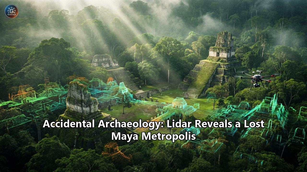
The scale of the revelation was immediate. The laser map revealed a dense concentration of stone structures: temple pyramids, enclosed plazas, a reservoir, and a complex network of causeways. It was a major political capital of the Classic Maya period (roughly 250–900 AD), sitting completely unrecorded by the scientific community. It was located just a 15-minute hike from a major highway near Xpujil, near where modern farmers had been tilling the soil for years, unaware that a lost metropolis lay beneath their feet.
Part II: Anatomy of a Ghost City
The city, which the team dubbed Valeriana after a nearby freshwater lagoon, is not a minor outpost. The analysis, published in the journal Antiquity, revealed a density of settlement that rivals the legendary Calakmul, long considered the mightiest of Maya cities in the region.
Across a survey area of approximately 122 square kilometers, the researchers identified 6,674 distinct structures.
The Core of ValerianaThe city is divided into two primary monumental precincts, linked by a dense suburban sprawl.
- The Architecture of Power: The main precinct possesses all the hallmarks of a Classic Maya capital. It features multiple enclosed plazas—vast public spaces where thousands would have gathered for rituals and markets. Rising above these plazas are temple pyramids, the stone mountains where kings communed with the gods.
- The Ballcourt: The scans clearly show an E-Group assemblage and a ballcourt, the quintessential Maya arena for the ritual ballgame pitz. These were not just sports venues; they were cosmic theaters where the movement of the sun and the cycles of life and death were reenacted.
- Water Engineering: Perhaps most impressive is the evidence of hydro-engineering. The Maya of the lowlands lived in a region with a distinct dry season and no major rivers. Survival depended on catching rain. Valeriana features a reservoir formed by damming an arroyo (a seasonal creek bed), a massive public work that implies a centralized government capable of mobilizing labor and managing critical resources.
What shocked the team was not just the temples—Maya pyramids are famous—but the stuff in between. The "empty" space between the monumental cores was filled with house mounds, terraces, and walkways. This wasn't a city with a sharp border; it was a landscape of continuous settlement.
"We didn't just find rural areas and smaller settlements," Auld-Thomas noted. "We also found a large city with pyramids right next to the area's only highway."
The implications of this density are profound. It suggests that Valeriana was home to between 30,000 and 50,000 people at its peak between 750 and 850 AD. To put that in perspective, this population is higher than the number of people living in the entire region today. The ancient jungle was more crowded, more engineered, and more cosmopolitan than the modern one.
Part III: The Magic of Lidar
To understand how Valeriana was found, one must understand the technology that is currently revolutionizing archaeology: Lidar.
In the past, mapping a Maya city took decades. Archaeologists would cut grid lines through the jungle, measuring mounds with tape and compass. It was slow, dangerous, and prone to error. A low stone platform covered in vines looks exactly like a natural bump in the ground until you dig into it.
Lidar changes the physics of discovery. It works by mounting a laser scanner on an aircraft (plane, helicopter, or drone). As the aircraft flies over the target area, the sensor fires hundreds of thousands of laser pulses per second at the ground.
- Most of these pulses hit the top of the tree canopy and bounce back.
- Some pulses penetrate the gaps between leaves and branches, hitting the undergrowth.
- A tiny fraction of the pulses travel all the way to the forest floor and bounce back to the sensor.
By measuring the time it takes for the light to return, the system calculates the distance. When the data is processed, algorithms can classify the returns. By deleting the "first returns" (the trees) and keeping only the "last returns" (the ground), archaeologists can digitally deforest the jungle.
The result is a "bare earth" model—a 3D topographic map that reveals the shape of the ground with centimeter-level precision. On these maps, the sharp angles of man-made stone structures pop out against the organic curves of the earth. Ancient roads (sacbeob) appear as straight lines cutting through the chaos; agricultural terraces look like ripples on a hillside; and pyramids stand out as perfect geometric squares.
The "Blank Spot" of CampecheThe discovery of Valeriana is particularly embarrassing for the "Empty Lowlands" hypothesis. For years, archaeologists focused on the Petén region of Guatemala (home to Tikal) and the Puuc region to the north. The area in between—central Campeche—was often viewed as a transitional zone, a rural backwater with few major centers.
The Lidar data proves this was an illusion caused by difficult terrain. This region is a "tropical karst" landscape, rugged and uneven, which made traditional foot surveys a nightmare. The jungle hid the ruins so effectively that you could walk within ten meters of a temple and never see it. Lidar, looking from above, has no such blind spots.
Part IV: Rewriting the History of the Maya
The discovery of Valeriana is the latest and loudest note in a growing chorus that is rewriting the demographic history of the Americas.
The Old Model: The Maya lived in isolated city-states separated by vast stretches of uninhabited wilderness. They practiced "slash and burn" agriculture, a low-density farming method that could not support massive populations. The New Model (revealed by Lidar): The Maya Lowlands were a "garden city" megalopolis. The settlements didn't end; they just thinned out and thickened again. The landscape was entirely anthropogenic—shaped by human hands.- Intensive Agriculture: The scans show extensive terracing and field systems, proving the Maya used intensive farming techniques to feed a massive population.
- Interconnectivity: A complex web of roads connected Valeriana to its neighbors, suggesting a high degree of economic and political integration.
- Total Occupation: "We have not found everything," Auld-Thomas said. The survey covered only 122 square kilometers of a region that spans thousands. If a city the size of Valeriana can hide in a random environmental survey, what lies in the rest of the jungle?
Dr. Marcello Canuto, a co-author of the study and director of the Middle American Research Institute at Tulane, emphasizes that this changes our view of the tropics. "Lidar is teaching us that, like many other ancient civilizations, the lowland Maya built a diverse tapestry of towns and communities over their tropical landscape."
This was not a civilization clinging to survival in a hostile jungle; it was a civilization that had tamed the jungle, engineering it into a thriving home for millions.
Part V: The Irony of the Collapse
The sheer density of Valeriana adds a tragic weight to the story of the Maya Collapse. The city flourished during the Classic period, reaching its zenith around 800 AD. Then, within a century, it was abandoned.
For years, scholars have debated the causes of the collapse: drought, warfare, political instability. The discovery of such immense population density supports the theory that the Maya outgrew their environment's carrying capacity.
Imagine a landscape "completely full of people," as Auld-Thomas describes it. Every acre of arable land is terraced and farmed. The reservoirs are the only source of water. When the climate shifted—when the great droughts of the 9th century arrived—there was no buffer. There was no "empty wilderness" to retreat to because the wilderness had been turned into suburbs. The system, stretched to its absolute limit by overpopulation and environmental engineering, unraveled.
The collapse of Valeriana was likely a humanitarian catastrophe. A city of 50,000 dissolved, its people scattering, leaving their stone temples to be reclaimed by the forest they had held back for centuries.
Part VI: The Future is Digital
The discovery of Valeriana marks a tipping point in archaeology. We are moving from an era of exploration to an era of data mining.
There is a poignant irony in how Luke Auld-Thomas found this city. He didn't need a pith helmet; he needed a high-speed internet connection and a search engine. The dataset had been sitting there for a decade, ignored. It forces us to ask: How many other lost cities are currently sitting on hard drives, buried in PDF annexes of environmental reports, or locked in unanalyzed server logs?
The challenge for the next generation of archaeologists is not just finding these sites, but protecting them. Now that Valeriana is on the map, it is vulnerable to looting. Yet, it also offers a tremendous opportunity. It is close to a road. It is near inhabited communities. It could become a new engine for tourism and heritage in Campeche, much like Chichén Itzá or Tulum.
As we stand on the brink of 2026, the jungle is no longer a place of secrets. The lasers have peeled back the canopy, and the ghosts of the Maya are looking back at us, revealing a civilization more complex, more crowded, and more human than we ever dared to imagine.
Valeriana is a reminder that the world is not yet fully known. Sometimes, the greatest discoveries aren't waiting in the most remote corners of the earth—they are waiting on page 16 of a Google search.
Reference:
- https://www.smithsonianmag.com/smart-news/found-dataset-reveals-lost-maya-city-hiding-in-plain-sight-beneath-a-mexican-forest-180985354/
- https://reason.com/2025/04/27/lost-cities-in-the-jungle/
- https://www.ladbible.com/news/uk-news/student-discovery-maya-city-mexico-valeriana-505926-20241029
- https://meobserver.org/culture/2025/01/01/the-major-historical-discovery-in-2024-lost-mayan-city-unearthed-in-mexico/
- https://futurism.com/the-byte/scientist-accidentally-discovers-ancient-mayan-city
- https://tollbit.beaumontenterprise.com/news/article/ancient-mayan-city-discovery-google-19877353.php
- https://www.youtube.com/watch?v=EsLP44cMi7w
- https://www.imveurope.com/article/student-finds-lost-maya-city-accident-using-lidar
- https://www.theguardian.com/world/2024/oct/29/lost-maya-city-valeriana-mexico-temple-pyramids-plazas
- https://en.wikipedia.org/wiki/Valeriana_(archaeological_site))
- https://news.artnet.com/art-world/lidar-reveals-lost-mayan-city-valeriana-2561336
- https://www.jpost.com/archaeology/archaeology-around-the-world/article-826833
- https://www.chichenitza.com/blog/valeriana-the-new-mayan-city-discovered-in-campeche
- https://archaeologymag.com/2024/10/lasers-uncover-lost-maya-city-in-mexico/