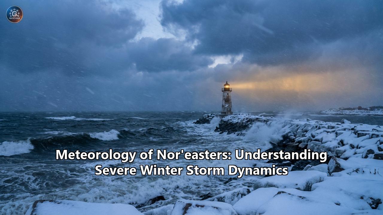
The sky takes on the color of a bruised plum, the barometric pressure plummets, and the wind begins a low, mournful howl from the northeast. Along the eastern seaboard of North America, these atmospheric cues signal the arrival of one of nature’s most awe-inspiring and destructive meteorological phenomena: the Nor'easter.
Often rivaling tropical hurricanes in their ferocity, Nor'easters are massive extratropical cyclones that can span a thousand miles, paralyzing major metropolitan areas, reshaping coastlines overnight, and plunging millions of people into the dark and cold. They are the winter leviathans of the Atlantic, born from a chaotic clash of extreme temperature gradients and atmospheric energy.
Understanding the meteorology of a Nor'easter requires a deep dive into the complex, invisible machinery of our atmosphere. From the microscopic release of latent heat to global teleconnections that span continents, the birth, life, and death of a severe winter storm is a masterclass in planetary physics.
The Anatomy of a Leviathan: What is a Nor'easter?
The term "Nor'easter" is steeped in maritime history, passing into American English from British mariners who noted the distinct wind patterns of these storms. Contrary to popular belief, a Nor'easter does not get its name because it strikes the Northeast region of the United States. Rather, the name describes the direction of the wind.
Because in the Northern Hemisphere wind flows counter-clockwise and inward around an area of low pressure, a storm tracking northward along the Atlantic coast will lash the shoreline with powerful winds blowing directly from the northeast. These winds drive moisture-laden ocean air inland, slamming it into freezing continental air masses.
While they can occur at any time of the year, Nor'easters typically develop most frequently and powerfully between the months of November and March. This seasonality is no coincidence; it is directly tied to the primary fuel source of these storms: the baroclinic zone.
The Baroclinic Battleground
At its core, the atmosphere is a giant heat engine striving for equilibrium. The equator is perpetually hot, and the poles are perpetually cold. Weather systems are simply the atmosphere's attempt to mix these extremes.
During the winter months, vast expanses of Canada and the Arctic become brutally cold, pooling massive domes of dense, dry, sub-zero polar air. Meanwhile, just a few hundred miles off the eastern coast of the United States, the Gulf Stream continues to pump a massive river of warm, tropical water northward. Even in the dead of winter, the surface waters of the Gulf Stream can hover around 70°F (21°C).
When the frigid Arctic air rushes southward and spills off the continent, it violently collides with the warm, moisture-rich air hovering above the Gulf Stream. This extreme thermal contrast—a sharp temperature gradient occurring over a very short distance—creates a highly unstable environment known as a baroclinic zone. The atmosphere responds to this severe imbalance by spinning up a low-pressure system to mix the air masses. The greater the temperature difference between the polar air and the warm ocean, the more explosive the atmospheric turbulence, and the more severe the resulting Nor'easter.
The Two Paths to Destruction: Miller Classifications
Not all Nor'easters are born the same way. In 1946, a pioneering meteorological researcher named J.E. Miller categorized the formation of these storms into two distinct evolutionary tracks, now famously known among meteorologists as Miller Type A and Miller Type B.
Miller Type A: The Classic Gulf-to-Coast Track
A Miller Type A Nor'easter is the textbook "classic" storm. Its life cycle begins far to the south, often developing as a low-pressure system over the Gulf of Mexico or just off the coasts of Georgia and South Carolina.
Tapping into the abundant tropical moisture of the Gulf, the storm organizes and begins to track northeastward, paralleling the Eastern Seaboard. As it moves up the coast, it feeds continuously off the warm waters of the Atlantic while simultaneously drawing in cold air from a high-pressure system situated over New England or Canada.
Because a Miller Type A storm has a relatively unobstructed path over open water, it can grow incredibly intense. These systems are notorious for blanketing the Mid-Atlantic and Northeast in crippling amounts of snow. The legendary "Storm of the Century" in March 1993—which dropped massive snowfall from Alabama to Maine and packed hurricane-force wind gusts—was a quintessential Miller Type A storm.
Miller Type B: The Coastal Redevelopment
A Miller Type B Nor'easter is vastly more complex and often presents a formidable forecasting challenge. These storms do not originate in the south; instead, they begin as low-pressure systems over the American Midwest or the Ohio and Tennessee River valleys.
As this primary low moves eastward, it runs headlong into the towering natural barrier of the Appalachian Mountains. The mountains disrupt the lower levels of the storm, physically tearing the surface circulation apart, causing the original low-pressure center to weaken and decay.
However, the upper-level energy of the storm—the trough in the jet stream—remains intact and leaps over the mountains. Once this upper-level energy reaches the Atlantic coast, usually near Cape Hatteras, North Carolina, or the Delmarva Peninsula, it finds the volatile baroclinic zone. This sparks a process called secondary cyclogenesis. A brand-new low-pressure center rapidly forms over the ocean, effectively transferring the storm's energy from the dying inland system to the newborn coastal system.
Miller Type B storms are infamous for delivering massive snowfalls to Northern New England and can transition from disorganized rain showers into roaring blizzards in a matter of hours as the new coastal low takes over.
The Invisible Architect: Cold Air Damming (CAD)
Whether a storm is a Miller Type A or B, one of the most critical ingredients for a severe winter weather event in the East is a phenomenon known as Cold Air Damming (CAD), colloquially referred to by meteorologists as "the wedge".
CAD occurs when a strong, expansive area of high pressure sits over eastern Canada or northern New England. Because winds flow clockwise around a high-pressure system, this feature drives freezing, dense Arctic air southward. As this dense air flows south, it meets the eastern slopes of the Appalachian Mountains. Unable to climb over the peaks, the cold air becomes trapped, or "dammed," against the mountains, pooling into a shallow, wedge-shaped layer of sub-freezing air at the surface.
When the warm, moist ocean air circulating around the advancing Nor'easter is blown inland, it encounters this dense wedge of cold air. Because warm air is lighter, it is forced to forcefully rise up and over the cold dome—a process called isentropic lift. As the warm air rises, it cools rapidly, wringing out massive amounts of precipitation.
Cold Air Damming is the primary reason why cities along the Interstate 95 corridor, from Washington D.C. to Boston, often become a battleground of precipitation types. If the cold wedge is thick enough, the precipitation falls as heavy snow. If the warm air aloft melts the snow, but the shallow wedge of cold air at the surface remains below freezing, the rain freezes on contact, resulting in a catastrophic ice storm.
Bombogenesis: The Anatomy of a Meteorological Bomb
While many Nor'easters bring unpleasant weather, only a select few evolve into historic, civilization-halting monsters. This transformation is usually the result of a process called explosive cyclogenesis, more popularly known as bombogenesis.
For a storm to be officially classified as a "bomb cyclone," its central barometric pressure must drop by at least 24 millibars within a 24-hour period.
This rapid plunge in pressure requires perfect synchronization between the surface and the upper atmosphere. High above the storm, at cruising altitude for commercial jets, speeds within the polar jet stream can exceed 150 mph. When a "jet streak" (a localized area of maximum wind speed within the jet stream) moves into the optimal position above the surface low, it creates intense divergence aloft. Essentially, the jet stream acts like an atmospheric vacuum cleaner, evacuating air from the top of the storm faster than the winds at the surface can replace it.
With so much mass being removed from the atmospheric column, the weight of the air drops, causing the surface pressure to plummet. This triggers a violent feedback loop. The lower the pressure falls, the faster the surrounding air rushes inward to fill the void. This inward rushing air pulls even more latent heat and moisture off the Gulf Stream. As that moisture is pulled upward into the storm's core, it condenses into clouds and precipitation, releasing immense amounts of latent heat energy, which further warms the core, lowers the pressure, and strengthens the winds.
The results of bombogenesis are terrifying. The historic "Bomb Cyclone" (Winter Storm Grayson) of January 2018 underwent a pressure drop of 53 millibars in just 21 hours—more than double the criteria for bombogenesis. This explosive deepening spawned hurricane-force wind gusts of 76 mph on Nantucket Island, brought a freezing storm surge into the financial district of Boston, and dumped over 17 inches of snow.
More recently, storms like Winter Storm Gianna in early 2026 have showcased similar explosive dynamics, rapidly intensifying off the Southeast coast and bringing blizzard conditions to the Outer Banks while pulling freezing, sub-zero Arctic air deep into the southern reaches of Florida.
The Sting Jet Phenomenon
Within the most violently deepening bomb cyclones, a rare and highly destructive micro-feature known as a "sting jet" can form. A sting jet occurs within the comma-head region of the cyclone, where dry air from the upper atmosphere intrudes into the storm's circulation (the "dry slot"). As precipitation falls into this dry air, it rapidly evaporates. Evaporation cools the air, making it incredibly dense. This dense, cold air then plummets toward the surface at astonishing speeds, transporting extreme, high-momentum upper-level winds directly to the ground. While brief and highly localized, sting jets are capable of producing catastrophic, tornado-like wind damage within the broader footprint of a Nor'easter.
The Global Maestros: Teleconnections and the NAO
Why do some winters feature a parade of relentless Nor'easters, while other winters are mild and largely storm-free? The answer lies thousands of miles away, in large-scale climate patterns known as teleconnections. The most influential teleconnection for East Coast winter weather is the North Atlantic Oscillation (NAO).
The NAO is a measure of the pressure difference between two semi-permanent atmospheric features: the sub-polar low-pressure system near Iceland (the Icelandic Low) and the high-pressure system near the Azores Islands (the Azores High).
When the NAO is in a Positive Phase, both the low and the high are stronger than normal. This creates a massive pressure gradient that supercharges the Atlantic jet stream, flattening it out and forcing it to flow rapidly from west to east. In this scenario, cold air stays trapped in the Arctic, and weather systems move quickly off the East Coast and out to sea before they have time to tap into Gulf Stream moisture and intensify.
However, when the NAO flips to a Negative Phase, the pressure difference weakens. The Icelandic Low fills in, and the Azores High diminishes. This lack of pressure gradient causes the jet stream to slow down and buckle wildly, creating massive atmospheric traffic jams.
The most prominent feature of a negative NAO is the development of a strong "blocking high" over Greenland—often referred to as the Greenland Block. This block acts like a boulder in a river, forcing the jet stream to dive deep into the southern United States, pulling polar air down with it. Furthermore, the blocking high physically prevents storms from escaping out to sea. When a Nor'easter forms under a negative NAO, it is forced to track slowly up the coast, hugging the shoreline and battering coastal communities for days on end.
The catastrophic Ash Wednesday Storm of 1962—which caused over $21 billion in damage in today's dollars—was trapped by a massive Greenland block, allowing the storm to hover off the coast and unleash high winds and storm surges over five consecutive high-tide cycles.
Impacts: A Multi-Hazard Onslaught
The sheer size and intensity of a Nor'easter mean that its impacts are not limited to just snow. These storms are multi-hazard events that strike simultaneously from the sky and the sea.
Coastal Flooding and Storm Surge
While hurricanes bring a surge of water driven by rapid, localized low pressure, a Nor'easter’s storm surge is driven by sheer geographic fetch. Because these storms can span over 1,000 miles and last for several days, their persistent, howling northeasterly winds act like a giant bulldozer, continuously pushing a massive wall of Atlantic ocean water toward the coast.
When this wind-driven surge coincides with high astronomical tides (especially full or new moons), the results are devastating. Unlike hurricanes, which usually move through an area in a matter of hours, a stalled Nor'easter will maintain its surge through multiple tide cycles. This relentless pounding strips away protective sand dunes, causes catastrophic beach erosion, and forces freezing, debris-filled ocean water into coastal towns. In places like Acadia National Park, the record-setting Nor'easters of January and March 2018 generated the highest tides in recorded history, fundamentally altering the shoreline.
Thundersnow and Convective Banding
Within the most intense Nor'easters, the atmosphere becomes so unstable that it begins to behave like a summer thunderstorm, but with sub-freezing temperatures. Heavy bands of precipitation, known as convective bands, form near the storm's center.
The upward motion of air within these bands is so violent that it causes ice crystals to collide violently with one another, stripping away electrons and building up massive static electrical charges. The result is "thundersnow"—a surreal phenomenon where blinding, heavy snowfall is illuminated by flashes of lightning, followed by the muffled, dampened rumble of thunder. When thundersnow is reported, it is a guarantee of extreme snowfall rates, often exceeding 2 to 4 inches per hour, which can overwhelm snow removal equipment and trap motorists on highways.
Climate Change: Are Nor'easters Getting Worse?
As human activity continues to pump greenhouse gases into the atmosphere, the Earth's oceans and air are warming. Given that Nor'easters feed directly off the temperature contrast between the continent and the ocean, determining how climate change will alter these storms has become a major focus of meteorological research.
The scientific consensus regarding the frequency of extratropical cyclones is somewhat mixed; some climate models suggest that as the Arctic warms faster than the equator, the overall temperature gradient will decrease, potentially leading to fewer total storms. However, when it comes to the intensity of the storms that do form, recent data presents a much more concerning picture.
A landmark 2025 study published in the Proceedings of the National Academy of Sciences (PNAS) applied sophisticated cyclone-tracking algorithms to historical weather data from 1940 to 2025. The researchers found a definitive, statistically significant trend: the strongest Nor'easters are becoming even stronger.
For the most extreme tier of Nor'easters (the top 1%), peak maximum wind speeds have increased by approximately 6% over the past 85 years. While 6% might sound like a small margin, wind power scales non-linearly. A 6% increase in wind speed translates to a roughly 20% increase in the destructive potential of the storm's winds, raising the threat of structural damage, power outages, and coastal erosion.
The physical mechanisms driving this intensification are well-understood by thermodynamic laws. First, sea surface temperatures in the Atlantic and Gulf Stream are rising. Warmer water evaporates more readily, injecting vastly more moisture and latent heat energy into the atmosphere. When a coastal storm taps into this supercharged moisture plume, the latent heat release during cloud formation is magnified, leading to more explosive drops in barometric pressure.
Secondly, the Clausius-Clapeyron relation states that for every 1°C increase in atmospheric temperature, the air can hold approximately 7% more water vapor. Consequently, the PNAS study also confirmed an increasing trend in hourly precipitation rates during these storms. Today's Nor'easters are dropping heavier rain and deeper, denser snow than their mid-20th-century counterparts.
While there is some debate in the broader atmospheric science community regarding the limitations of historical datasets (such as the ERA5 reanalysis underestimating historical wind speeds) and the role of natural multi-decadal ocean cycles, the thermodynamic reality remains: warmer oceans provide more fuel, and a warmer atmosphere holds more water, preconditioning the environment for more devastating impacts when the right atmospheric triggers align.
The Science of Forecasting the Unpredictable
Despite massive leaps in technology, predicting the exact track, intensity, and precipitation type of a Nor'easter remains one of the greatest challenges in modern meteorology.
Forecasters rely on highly sophisticated supercomputer models, such as the American GFS (Global Forecast System) and the European ECMWF. These models ingest billions of data points from weather balloons, commercial aircraft, ocean buoys, and satellites. Yet, a shift in the storm's track by just 50 miles east or west—a microscopic margin of error on a global scale—can mean the difference between a cold, manageable rain in New York City and a paralyzing 2-foot blizzard.
Today, meteorologists also heavily utilize the advanced GOES-16 and GOES-18 satellites. These satellites provide high-resolution, minute-by-minute water vapor imagery, allowing forecasters to see the invisible rivers of moisture feeding the storm, track the descent of dry stratospheric air into the storm's core (the tell-tale sign of a deepening low), and identify the signature "comma-head" cloud structure that signifies a mature, powerful cyclone.
Respecting the Winter Fury
The meteorology of a Nor'easter is a breathtaking display of Earth's atmospheric dynamics. These storms represent nature’s violent attempt to balance the thermal scales of our planet, drawing upon the blistering cold of the Arctic, the tropical warmth of the Gulf Stream, and the high-altitude roar of the jet stream.
Whether it is a Miller Type A born in the Gulf, or a Miller Type B leaping the Appalachians to bomb out off the coast, a severe Nor'easter commands ultimate respect. As coastal populations grow and climate pollution continues to supercharge our atmosphere and oceans, the destructive potential of these winter leviathans will likely only increase.
For the millions of people living along the eastern coast of North America, understanding the mechanics of these storms is more than an exercise in atmospheric science; it is a vital necessity for survival and adaptation in a warming, increasingly volatile world. The wind will inevitably howl from the northeast again—and when the barometric pressure begins to free-fall, the only thing left to do is prepare for the storm.
Reference:
- https://en.wikipedia.org/wiki/Nor%27easter
- https://wildcardweather.com/2014/12/01/how-noreasters-form/
- https://www.cbs8.com/article/weather/possible-noreaster-could-bring-heavy-snow-and-strong-winds-to-the-east-coast-this-weekend/507-c52b2bce-b54b-466a-8d52-1118412af80d
- https://www.flyingmag.com/winter-on-watch/
- https://appstate.edu/~perrylb/Research/Publications/Misc/Perry_2006_Diss.pdf
- https://www.thehotelwashington.com/washington-dc-travel-guide/bomb-cyclone-noreaster-washington-dc-weekend
- https://www.kiro7.com/unavailable-location/
- https://courses.ems.psu.edu/earth107/node/1522
- https://www.pnas.org/doi/10.1073/pnas.2510029122
- https://www.severe-weather.eu/global-weather/polar-vortex-collapse-winter-storm-noreaster-bomb-cyclone-snow-cold-florida-united-states-mk/
- https://www.climate.gov/news-features/understanding-climate/climate-variability-north-atlantic-oscillation
- https://wcd.copernicus.org/preprints/wcd-2020-20/wcd-2020-20.pdf
- https://eos.org/articles/new-research-shows-more-extreme-global-warming-impacts-looming-for-the-northeast
- https://www.nps.gov/acad/learn/nature/noreasters.htm
- https://www.livescience.com/planet-earth/climate-change/noreasters-have-become-20-percent-more-destructive-in-the-last-80-years-scientists-warn
- https://rogerpielkejr.substack.com/p/are-the-strongest-noreasters-getting
- https://www.reddit.com/r/climate/comments/1m00ags/the_strongest_noreasters_are_being_supercharged/