The wind that scours the Pisco Valley is older than the Incas, older than the Chincha kings who once ruled this arid strip of Peruvian coast, and certainly older than the mystery that scars the face of Monte Sierpe. For centuries, the locals have looked up at the barren ridge of the "Serpent Mountain" and seen the pockmarks of the gods—or perhaps the devil. They call it the Band of Holes. From the ground, it looks like a chaotic, senseless act of vandalism upon the earth, a miles-long trench of excavated pits that serve no apparent purpose. They hold no water. They contain no gold. They are too shallow for graves and too strange for defense.
It wasn't until 1933, when an American aviator named Robert Shippee flew a biplane over the valley, that the true scale of the enigma was revealed. From the air, the chaos resolved into a chillingly precise order. A band of over 5,000 man-made craters, perfectly aligned, snakes its way up the mountain spine like the vertebrae of a colossal beast. It is a monument to a forgotten logic, a code carved into the crust of the Andes that has remained unbroken for five hundred years.
Until now.
This is the story of Monte Sierpe, the "Incan Mountain of Economic Tribute." It is a detective story that spans centuries, linking the salty spray of Chincha trading rafts to the knotted strings of Inca accountants, and finally to the drone-equipped archaeologists of the 21st century who are peeling back the layers of history to reveal not a temple of worship, but a temple of commerce—a massive, landscape-scale spreadsheet used to manage the tribute of an empire.
Part I: The Serpent in the Stone
The Aviator’s Discovery
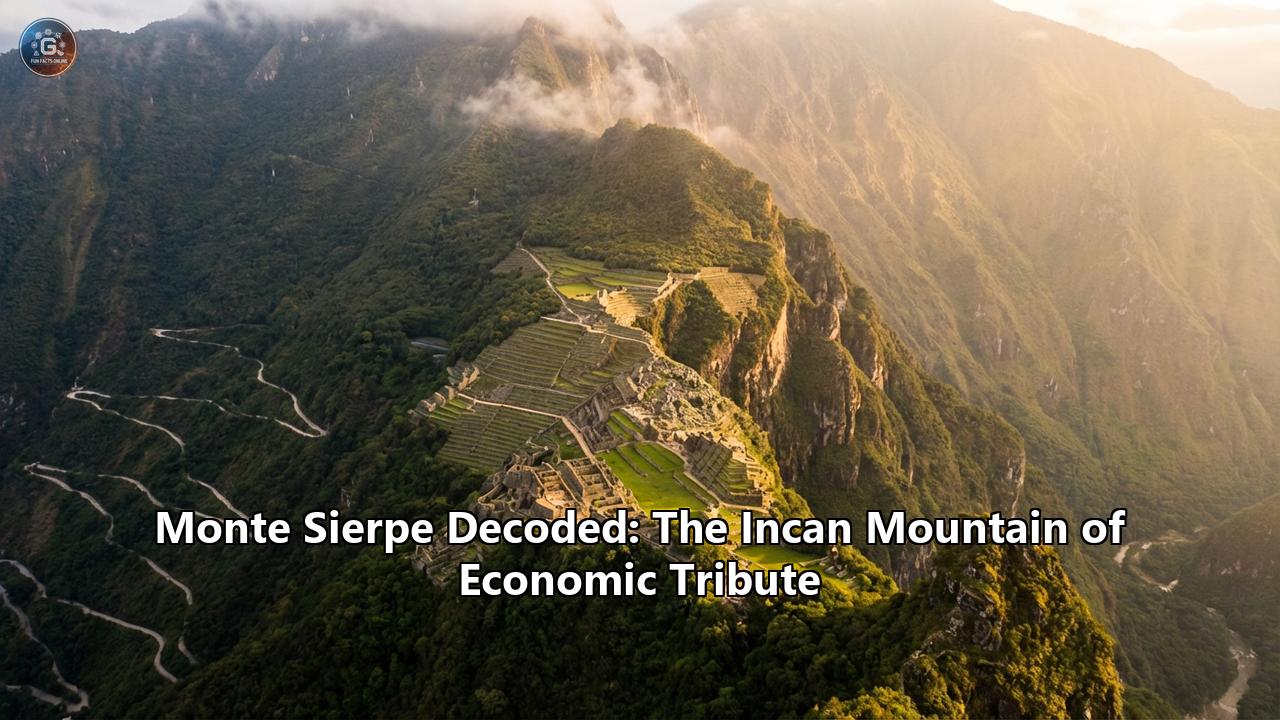
In the early 1930s, the world was still full of blank spots on the map, at least in the popular imagination. Robert Shippee, a dashing figure in the golden age of aviation, had come to Peru to document the "air wonders" of the Andes for the National Geographic Society. His mission was to capture the grandeur of the Colca Canyon and the majesty of Machu Picchu. But as his open-cockpit plane buzzed over the Pisco Valley, roughly 200 miles south of Lima, he saw something that wasn't on any chart.
Below him, the brown, dusty ridge of Monte Sierpe rose from the valley floor. Etched into its surface was a band of dark spots, varying in width from 15 to 20 meters, stretching for nearly a mile and a half. It undulated with the terrain, rising and falling over the rugged topography, yet maintaining a disciplined, almost machine-like consistency.
Shippee banked his plane for a closer look. What he saw defied explanation. These were not natural formations. They were holes—thousands of them—excavated with deliberate intent. They were arranged in rows, but the rows were broken into distinct rectangular blocks, separated by untouched strips of earth. It looked, to his modern eyes, like a giant punch card or a strip of film negative laid out on the mountain.
When he landed and asked the locals about the site, the answers were a mix of superstition and shrugs. Some called it Cerro Viruela (Smallpox Hill), likening the pits to the scars of the disease that had ravaged the indigenous populations. Others whispered of ancient graves, looted long ago. But when Shippee and his team hiked up to investigate, they found only empty pits. No bones, no pottery shards, no gold. Just stone-lined hollows, roughly a meter deep and wide enough for a man to crouch in.
For decades after Shippee’s photos were published, the "Band of Holes" remained a fringe curiosity. It became a darling of the "ancient astronaut" theorists, who saw in its grid-like precision a landing strip for UFOs or a message beamed to the stars. Archaeologists, lacking the budget or the context to understand it, largely stayed away. It was an orphan of history, a massive monument without a clear builder or a clear purpose.
The Geography of the Mystery
To understand Monte Sierpe, one must first understand the land that holds it. The Pisco Valley is a "chaupiyunga"—a Quechua term for the transitional zone between the coastal desert and the high Andes. This is a land of dramatic contrasts. To the west lies the Pacific Ocean, cold and rich with anchovies and shellfish. To the east, the Andes rise like a wall, their peaks hidden in clouds, home to the potato fields and llama herds of the highlands.
The Pisco Valley is a corridor, a natural highway connecting these two worlds. For thousands of years, trade caravans have walked this route, carrying dried fish, cotton, and chili peppers up to the mountains, and bringing down wool, metal, and potatoes to the coast. Monte Sierpe sits at a strategic choke point on this route. It overlooks the valley floor where the river winds its way to the sea.
The site itself is unforgiving. The ridge is exposed to the baking sun and the biting wind. There is no water source on the mountain itself. Whoever built the Band of Holes did not do so for comfort. They built it to be seen, or perhaps, to be used in a way that required this specific, difficult location. The band stretches north to south, cutting across the natural grain of the land. It is an imposition of order on a chaotic landscape.
The holes themselves are a marvel of labor. There are approximately 5,200 of them. Some are dug directly into the rocky soil; others are lined with stones to prevent collapse. They are not uniform. Some are shallow depressions; others are deep, cylindrical pits. They are grouped into strange "blocks"—a section of nine rows might be followed by a gap, then a section of four rows. The pattern is complex, almost rhythmic, hinting at a language of numbers that we have long forgotten.
Part II: The Lords of the Sea
Before the Incas ever set foot in the Pisco Valley, this land belonged to the Chincha.
If the Incas were the Romans of the Andes—conquerors, road-builders, administrators—the Chincha were its Phoenicians. They were a thalassocracy, a kingdom whose power lay not just in the soil, but in the waves. By the Late Intermediate Period (1000–1400 AD), the Chincha Kingdom had grown into a wealthy and powerful state. Their capital, La Centinela, was a sprawling complex of adobe pyramids and plazas, bustling with merchants and artisans.
The Merchants of Spondylus
The source of Chincha wealth was trade. They were the masters of the balsa raft, a sturdy, ocean-going vessel made from the buoyant logs of the balsa tree. These were not simple fishing boats; they were cargo ships of the ancient world, equipped with cotton sails and capable of carrying tons of goods.
Chincha pilots navigated the currents of the Pacific, sailing as far north as Ecuador. Their prize was the Spondylus shell—the "thorny oyster." This spiny, pinkish-orange shell was more valuable than gold in the Andean world. It was the food of the gods, essential for rain rituals and offerings to the Pachamama (Mother Earth). The warm waters of Ecuador were the only place the Spondylus grew, and the Chincha controlled the flow of this sacred commodity into the southern Andes.
But the Chincha didn't just look north to the sea; they looked east to the mountains. They established a vast network of camelid caravans—thousands of llamas carrying goods from the coast to the high antiplano. They were the middlemen of the Andes, the great exchange mechanism that kept the diverse ecological zones of the continent connected.
A Market at Monte Sierpe?
It is in this context of trade and exchange that the first clues to Monte Sierpe’s origin appear. Recent archaeological work, led by researchers like Dr. Jacob Bongers, has begun to peel back the Inca veneer of the site to reveal its Chincha foundations.
Imagine the Pisco Valley in the year 1300 AD. It is a bustling thoroughfare. Caravans of llamas, laden with dried fish and seaweed, are trudging up the valley floor. Coming down from the mountains are porters carrying bags of charqui (dried meat) and wool. They meet in the chaupiyunga, the neutral ground between the coast and the highlands.
Bongers and his team propose that Monte Sierpe began its life here, not as a state monument, but as a marketplace. The "holes" may have started as storage pits, places where traders could deposit their goods securely while negotiations took place. The strange, segmented layout of the site might have corresponded to different merchant groups or different types of goods.
Soil samples taken from the bottom of these pits have yielded a smoking gun: pollen. Not just the random pollen of the desert wind, but concentrated amounts of maize (corn) and squash, along with traces of the reeds used to make woven bags and mats. This suggests that these holes were once filled with agricultural produce.
Picture a massive, open-air bazaar. The holes are lined with reed mats. In one block of pits, a merchant from the coast has stored piles of dried maize. In another, a highlander has stacked bags of potatoes. The "Band of Holes" acts as a physical ledger, a way to organize and display the massive quantities of goods being exchanged. It is a primitive but effective form of warehousing, built directly into the geology of the trade route.
For centuries, this system likely worked on a local level—a "flea market" of the Andes, as Bongers has called it. But then, on the horizon, a new power appeared. The Incas were coming.
Part III: The Empire of the Sun
The expansion of the Inca Empire (Tawantinsuyu) in the 15th century was a marvel of speed and organization. Under the leadership of Pachacuti and his successors, the Incas surged out of their highland capital of Cusco, absorbing kingdom after kingdom.
When they reached the Chincha, however, something interesting happened. The Incas, usually ruthless conquerors, recognized the value of the Chincha merchant network. They didn't just want to destroy it; they wanted to own it. The integration of the Chincha into the Inca Empire was, by many accounts, a negotiated annexation. The Chincha lords were allowed to keep their privileges and their wealth, provided they bent the knee to the Sapa Inca and turned their mighty trade network toward the service of the Empire.
The Mit'a: A Tax of Sweat and Service
To understand what the Incas did to Monte Sierpe, you have to understand how the Inca economy worked. It was a system without money. There were no coins, no banknotes, no credit cards. Yet, the Incas managed an empire of 12 million people, built thousands of miles of roads, and constructed cities that astound us to this day.
They did it through labor.
The Inca tax system was based on the mit'a (meaning "turn" or "season"). Every able-bodied citizen owed the state a certain amount of labor each year. This could take many forms. You might be drafted to build a suspension bridge. You might be sent to the mines. You might serve in the army. Or, if you were a farmer, you would work on state-owned lands, producing crops that went directly into the state's storehouses (qollcas).
This system created a massive logistical challenge. The state had to track millions of labor hours. They had to track the tons of maize, potatoes, and textiles produced by this labor. They had to know exactly how much tribute each province had paid and how much was stored in the warehouses for times of famine or war.
Without a written language, how did they manage this ocean of data? They used the khipu.
The Khipu: The Computer of Knots
The khipu (or quipu) is one of the most ingenious inventions of the ancient world. It looks like a mop head—a main cord with dozens or hundreds of subsidiary cords hanging from it. By tying knots of different types and sizes at different positions on these cords, the Inca bureaucrats (khipukamayuqs) could record almost anything.
It was a decimal system. A knot at the bottom of a cord might represent "ones." A knot higher up represented "tens," then "hundreds," and so on. The color of the string might indicate the item being counted—yellow for gold, red for war, white for silver, green for grain.
The khipu was portable, durable, and precise. It allowed the Incas to run a centralized command-and-control economy across some of the most rugged terrain on Earth. But a khipu is a personal device. You can hold it in your hands. What if you needed to demonstrate the tribute of an entire valley? What if you wanted to create a record that could be seen by the gods, or perhaps, by a tax collector standing on a distant hill?
This brings us back to Monte Sierpe.
Part IV: The Landscape Khipu
In the early 2010s, archaeologists Charles Stanish and Henry Tantaleán took a fresh look at the Band of Holes. They weren't satisfied with the vague theories of the past. They brought with them a deep understanding of Inca statecraft and the political economy of the Andes.
Their hypothesis was radical: Monte Sierpe was not just a storage site. It was a translation of the khipu into stone. It was a massive, geoglyphic spreadsheet.
Decoding the Pattern
Stanish and Tantaleán mapped the site with unprecedented precision. They noticed that the "blocks" of holes were not random. They were segmented in a way that mimicked the structure of a khipu.
On a string khipu, you have groups of cords separated by spaces. At Monte Sierpe, you have blocks of holes separated by empty strips of land. On a khipu, you have specific numerical values encoded in knots. At Monte Sierpe, the number of holes in a row or a block seemed to follow a similar counting logic.
The researchers proposed that the site functioned as a place of ritualized accounting.
Imagine the scene: It is harvest time. The local communities of the Pisco Valley have paid their mit'a tribute. They arrive at Monte Sierpe carrying thousands of bushels of maize, squash, and cotton. This is a solemn occasion, a mix of tax day and religious festival.
The Inca administrators are waiting. They direct the porters to specific blocks of holes.
"Community A," the official might say, "fill this block of 100 holes with your maize."
Each hole is a standard unit of measure. One hole might equal one fanega (a traditional measure of volume).
As the workers pour their tribute into the pits, the "spreadsheet" fills up. The empty holes are the zeros. The filled holes are the data. When the process is done, the entire tribute of the valley is physically laid out on the mountainside.
This served two purposes.
- Verification: It was a transparent system. Everyone could see that the tribute had been paid. The local lords could show the Inca officials, "Look, our block is full. We have met our quota."
- Conversion: Once the holes were filled and verified, the khipukamayuqs would walk the lines. They would count the filled holes and tie the corresponding knots into their portable string khipus. The data was transferred from the "hard drive" of the mountain to the "flash drive" of the strings, which would then be carried to the administrative center at Tambo Colorado or even back to Cusco.
The "Checkboard" of the State
This theory explains the strange variation in the holes. The different blocks could represent different communities (ayllus) or different types of goods. The rigorous linear arrangement allowed for easy counting. It was a system designed to prevent cheating. You can't hide a missing bushel if the hole is empty.
Stanish and Tantaleán’s theory also aligns with what we know of Inca "performance." The Incas loved spectacle. They didn't just want to collect taxes; they wanted to perform the act of taxation to reinforce their power. Filling the Band of Holes was a public performance of submission and abundance. It turned the dry, boring work of accounting into a grand ritual visible from the valley floor.
Recent drone studies have strengthened this link. The mathematical segmentation of the site—groups of holes that sum up to specific numbers—has been shown to statistically resemble the grouping of cords on khipus found in the same region. One study found a khipu in a nearby burial that had a knot pattern strikingly similar to the arrangement of a specific section of the Band of Holes. It is as if we have found the paper receipt that matches the digital entry.
Part V: The Echoes of Empire
The Inca Empire fell swiftly and violently. When the Spanish arrived in the 1530s, they had no interest in the sophisticated accounting systems of the people they conquered. They melted down the gold and burned the khipus, dismissing them as the devil's work.
Monte Sierpe was abandoned. The maize in the pits rotted or was eaten by rodents. The wind began to fill the holes with dust. The great "ledger of the mountain" was wiped clean, its data lost to entropy.
However, the site didn't disappear. It sat there, silently enduring the colonial era and the modern age, a riddle waiting for an answer.
Visiting the Enigma
Today, Monte Sierpe is a place of haunting solitude. It lies off the beaten path, far from the tourist crowds of Cusco. To visit it is an adventure. You travel from the coastal town of Pisco, driving inland through the stark, lunar landscapes of the desert foothills.
The site is near the Inca ruins of Tambo Colorado, an exceptionally well-preserved adobe administrative center that was likely the headquarters for the officials who managed the Band of Holes. Tambo Colorado is famous for its surviving paint—walls still stained in bands of red, yellow, and white. It helps to visualize the world of color and order that the Incas imposed on this beige desert.
Hiking up to the Band of Holes, the first thing that strikes you is the wind. It howls across the ridge. Then, the sheer scale of the labor hits you. Standing inside one of the pits, looking down the line at thousands of others, you feel a profound connection to the people who dug them. You can almost hear the scrape of stone tools and the murmur of Quechua voices tallying the harvest.
It is not a "pretty" ruin. There are no carved monoliths or intricate statues. But it is intellectually beautiful. It is a monument to the human mind's desire to organize the world.
A Warning from the Past
The story of Monte Sierpe is also a cautionary tale. For decades, the site was dismissed or exoticized. The "alien" theories were a way of robbing the indigenous people of their intellect. By claiming that such a complex mathematical structure must be extraterrestrial, we denied the Andean people their heritage as master administrators and economists.
The work of Stanish, Tantaleán, Bongers, and others has restored that heritage. They have shown that the Incas didn't need aliens to build a spreadsheet on a mountain. They had a sophisticated understanding of data, logistics, and statecraft that rivaled any civilization in the Old World.
Conclusion: The Mountain that Counted
Monte Sierpe remains one of the most fascinating, yet under-appreciated, archaeological sites in the Americas. It is a bridge between two eras—the maritime commercialism of the Chincha and the agrarian socialism of the Inca.
It represents a moment in history where trade met tribute, where the chaos of the market was tamed by the order of the state. It challenges our modern assumptions about what "economy" looks like. We think of economy as numbers on a screen, invisible and abstract. For the Incas, the economy was physical. It was sweat, it was maize, it was a hole in the ground that had to be filled.
As you fly over the Pisco Valley today, the Band of Holes is still there, a pixelated scar on the timeless Andes. It is no longer used to count the tribute of an empire, but it still counts something. It counts the days, the years, and the centuries that have passed since the last khipukamayuq walked its lines, proving that while empires may fall, the human need to make sense of the world—to count, to store, to order—is eternal.
The mystery of the holes is no longer a mystery of "what." It is a marvel of "how." And in that marvel, we find the true genius of the Andean world.
Reference:
- https://www.researchgate.net/publication/397459306_Indigenous_accounting_and_exchange_at_Monte_Sierpe_'Band_of_Holes'_in_the_Pisco_Valley_Peru
- https://www.cambridge.org/core/journals/antiquity/article/indigenous-accounting-and-exchange-at-monte-sierpe-band-of-holes-in-the-pisco-valley-peru/41D83389D230D99CFF18194CF274A9A3
- https://archaeology.org/news/2025/11/11/drone-mapping-offers-insight-into-perus-band-of-holes/
- https://www.sydney.edu.au/news-opinion/news/2025/11/10/mysterious-holes-in-the-andes-may-have-been-an-ancient-marketplace-new-research-suggests.html
- https://arkeonews.net/monte-sierpe-perus-mysterious-band-of-holes-may-have-been-an-ancient-marketplace/
- https://www.academia.edu/36153436/The_Strange_Site_of_Monte_Sierpe_Band_of_Holes_in_the_Pisco_Valley_Peru
- https://en.wikipedia.org/wiki/Chincha_culture
- https://www.researchgate.net/publication/284518110_Negotiated_Subjugation_Maritime_Trade_and_the_Incorporation_of_Chincha_Into_the_Inca_Empire
- https://www.scimex.org/newsfeed/mysterious-holes-in-the-andes-may-have-been-an-ancient-marketplace-study-suggests
- https://en.wikipedia.org/wiki/History_of_the_Incas
- https://www.youtube.com/watch?v=HrfKOQKyffE
- https://www.peruforless.com/blog/quipu
- https://www.nist.gov/nist-museum/standardizing-empire
- https://en.wikipedia.org/wiki/Quipu
- https://smarthistory.org/inka-khipu/