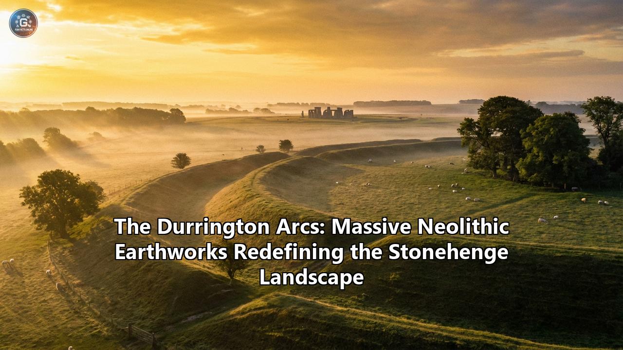
The air above Salisbury Plain is often cold, whipping across the chalk grasslands that have guarded the secrets of the British Isles for millennia. For centuries, antiquarians, tourists, and Druids have flocked to the stone lintels of Stonehenge, convinced that the heavy sarson stones were the apex of Neolithic achievement. They looked at the moss-covered giants and believed they were seeing the whole picture. They were wrong.
Just two miles to the northeast, hidden beneath the turf, lay a monument so vast, so ambitious, and so geometrically precise that it dwarfs its famous stone neighbor. It remained invisible to the naked eye, walked over by unsuspecting hikers and farmers for four thousand years. Its discovery did not come from the thrust of a shovel, but from the pulse of a radar beam.
These are the Durrington Arcs—a massive series of subterranean shafts arranging themselves in a colossal circuit that redefines everything we thought we knew about the people who built Stonehenge. This is the story of the largest prehistoric structure ever discovered in Britain, a ghost monument that has risen from the digital data to challenge our understanding of the Neolithic world.
Part I: The Invisible Giants
The history of archaeology is often romanticized as the pursuit of gold masks and stone idols, of digging deep into the earth to recover the tangible debris of the past. But the twenty-first century has ushered in a quiet revolution. The Stonehenge Hidden Landscapes Project (SHLP) was not designed to dig, but to see. Using a suite of non-invasive technologies—ground-penetrating radar (GPR), magnetometers, and electromagnetic induction sensors—the team set out to map the "empty" spaces between the known monuments of the Salisbury Plain.
For years, the area surrounding the super-henge of Durrington Walls was thought to be relatively quiet, a buffer zone for the bustling Neolithic settlement that once thrived there. When the data began to stream in, however, anomalies appeared on the screens that defied the standard categorization of "dewponds" or "natural sinkholes."
These anomalies were regular. They were rhythmic. And they were massive.
What the sensors revealed was a series of immense pits, each measuring roughly 10 to 20 meters in diameter and plunging at least 5 meters into the chalk bedrock. To put this in perspective, each single shaft is large enough to swallow a terraced house. But it was their arrangement that sent shockwaves through the archaeological community. These were not random scars on the landscape; they were arranged in a segmented circle, or a series of arcs, with a diameter of 2 kilometers (1.2 miles).
This circuit encloses an area of more than 3 square kilometers. It encircles the super-henge of Durrington Walls and the timber monument of Woodhenge. It is a boundary of epic proportions, a "keep out" sign or a "holy precinct" marker built on a scale that suggests a mobilization of labor previously thought impossible for the time.
Part II: The Anatomy of the Earthworks
To understand the Durrington Arcs, one must appreciate the sheer physical toll of their construction. The Neolithic Britons did not have metal shovels or pickaxes. They worked with the antlers of red deer, used as picks to lever out the stubborn chalk, and the shoulder blades of cattle, used as shovels to scrape away the debris.
Excavating a ditch is one thing; excavating a vertical shaft 5 meters deep and 10 meters wide is a feat of engineering. The sides of these pits are nearly vertical, a cylindrical puncture into the earth that would have required complex staging to remove the spoil.
Calculations based on the volume of chalk removed suggest that digging the full circuit would have required thousands of person-hours. Yet, unlike the ditches of a henge which form a continuous barrier, these shafts were spaced. The distance between them is fairly consistent, suggesting a pacing or counting system was used—a Neolithic yardstick. This implies that the architects of the Arcs possessed a sophistication in geometry and measurement that we have long denied them.
The placement of the Arcs is not arbitrary. They are centered not on Stonehenge, but on the Durrington Walls henge. However, the circuit is not a perfect circle. It bulges and weaves slightly. Why? The answer lies in the deep time of the landscape. The Arcs appear to respect the position of the Larkhill Causewayed Enclosure, a monument that was already 1,500 years old when the Arcs were dug.
This detail is profound. It suggests that the builders of the Arcs were aware of their history. They were navigating a landscape that was already "ancient" to them. They bent their massive line of pits to avoid cutting through the sacred remains of their ancestors at Larkhill, weaving a thread of continuity that spans millennia.
Part III: The Land of the Living vs. The Land of the Dead
To grasp the ritual significance of the Durrington Arcs, we must look at the duality of the Stonehenge landscape. Archaeologist Mike Parker Pearson has long championed the theory of a divided world: Stonehenge, with its permanent stone structures, was the domain of the ancestors—the Land of the Dead. Durrington Walls, with its timber circles and evidence of massive feasting, was the Land of the Living.
Durrington Walls was the settlement where the builders of Stonehenge lived. Excavations there have revealed the floors of houses, hearths, and tens of thousands of animal bones, primarily pigs, showing that people gathered there for midwinter feasts. It was a place of life, noise, fire, and flesh.
The discovery of the Arcs amplifies this duality. If Durrington Walls was the bustling city of the living, the Arcs created a massive containment zone around it.
Why encircle the living with such a formidable barrier?
There are several theories. One is protection. Not necessarily from armies—Neolithic warfare is a subject of debate, and these pits are not defensive fortifications in the traditional sense (a determined attacker could walk between them)—but spiritual protection. The Arcs may have served as a cosmological containment field, keeping the chaotic energy of the living separate from the wider landscape of the dead, or perhaps protecting the settlement from the spirits wandering the plain.
Another theory is guidance. The Arcs may have acted as a permeable boundary. The gaps between the shafts would allow movement, but the massive pits would serve as waypoints, guiding processions toward the River Avon, which connects the Land of the Living (Durrington) to the Land of the Dead (Stonehenge).
Part IV: The Chronology of a "Big Bang"
One of the most critical questions facing the Hidden Landscapes team was "When?" When were these giants carved?
Using Optically Stimulated Luminescence (OSL) dating—a technique that determines the last time sediment was exposed to sunlight—and radiocarbon dating of bone fragments found deep within the silts, the team pinpointed the construction to roughly 2500 BC.
This date is electric. 2500 BC is the "golden hour" of the British Neolithic. It is the exact time that the massive sarsen stones were being erected at Stonehenge. It is the time of the great feasts at Durrington Walls. It is the time when the Grooved Ware pottery style was spreading across Britain.
The synchronicity is staggering. It suggests that the construction of the stone circle at Stonehenge and the digging of the massive earthworks at Durrington were part of a single, unified building program. The society of 2500 BC was not building one monument at a time; they were terraforming their entire world.
The scale of this simultaneous construction requires us to rethink the social structure of Neolithic Britain. This was not a loose collection of farming families. This was a centralized, highly organized society capable of commanding vast labor forces, feeding them, housing them, and directing them to alter the earth on a geological scale.
Part V: Environmental DNA and the Lost World
The Arcs are not just holes; they are time capsules. Because they are deep and cut into chalk, the sediment at the bottom has been preserved in stable conditions. This allowed scientists to utilize a cutting-edge technique: Sedimentary Ancient DNA (sedaDNA).
By sequencing the DNA found in the soil at the bottom of the pits, researchers reconstructed the environment of 2500 BC. They found traces of the plants that grew there and the animals that walked the rim of the pits.
The data paints a picture of a specialized landscape. It was not a dense forest, but an open, managed woodland with hazel, oak, and fruit-bearing trees. There is evidence of domestic dogs, pigs, and cattle. This confirms that the area was heavily used and managed by humans. It was a "parkland," curated for the massive gatherings that took place there.
Crucially, the analysis of the silts showed that the pits were left open. They were not dug and immediately backfilled (as was common with some ritual pits). They were allowed to silt up naturally over centuries. This means that for hundreds of years, these gaping white scars in the green grass would have been visible, a permanent reminder of the boundary they enforced.
Part VI: Cosmology and Counting
The mathematical implications of the Durrington Arcs are perhaps the most controversial and exciting aspect of the discovery.
To create a circle of this size, maintaining a relatively constant radius from a central point (the henge), requires surveying skills. You cannot simply "eyeball" a 2-kilometer wide circle.
Furthermore, the spacing between the shafts is relatively uniform. This consistency implies a standard of measurement. Whether it was paced out by a person of a specific height or measured using a rod or cord, it suggests a system of counting.
In a pre-literate society, how do you count to such high numbers? How do you organize a circumference of over 6 kilometers? The Arcs suggest that Neolithic people had a numeracy that went far beyond simple tallies. They were imposing a geometric order on the natural world.
The alignment of the pits may also have astronomical significance. While Stonehenge is famously aligned with the solstices (sunrise at midsummer, sunset at midwinter), the Arcs may have marked the rising and setting of other celestial bodies, or simply served to demarcate the "world" of the settlement from the "wild" of the universe beyond.
Part VII: The Mystery of the Missing Stones
The relationship between the Arcs and the stones of the area is complex. Durrington Walls was primarily a timber monument. It had massive wooden circles (the Northern and Southern Circles). Wood rots, while stone survives. This transience of wood is often linked to the transience of life.
However, there was a moment when stone and timber met. The famous Bluestonehenge (or West Amesbury Henge) lies at the end of the Stonehenge Avenue near the river. It was a circle of Welsh bluestones.
The Arcs encircle the timber monuments. They are earthworks, made of the very body of the land. In the Neolithic mind, there seems to be a hierarchy of materials:
- Timber: Living, decaying, for the people.
- Earth (Chalk): The white bone of the land, used for boundaries and enclosures.
- Stone: Eternal, dead, for the ancestors.
The Arcs, being earthworks, fall into the category of defining the land itself. They are negative space—material removed to create meaning. This contrasts beautifully with Stonehenge, which is positive space—material added to create meaning.
Part VIII: A Landscape Redefined
Before the discovery of the Arcs, we viewed Durrington Walls as a "site." It was a dot on the map, distinct from the dot of Stonehenge.
The Arcs have erased the dots and drawn a web. They show us that the entire landscape was the monument. You did not "arrive" at Durrington Walls only when you crossed the bank of the henge. You entered the sacred precinct the moment you crossed the line of the Arcs, a kilometer away.
This changes the visitor experience of the past. A pilgrim approaching Durrington Walls in 2500 BC would encounter the white sentinels of the shafts long before they saw the timber circles. They would know they were crossing a threshold. The sheer size of the enclosure meant that the "sacred space" was vast—large enough to hold thousands of people, their herds, and their temporary homes.
It transforms Durrington Walls from a "village" into a "city-state" of ritual. The Arcs are the city walls, but made of ritual power rather than defensive stone.
Part IX: The Future of the Past
The discovery of the Durrington Arcs serves as a humbling reminder of how much we still do not know. For centuries, we walked over the largest prehistoric monument in Britain without knowing it was there.
It validates the shift in archaeology toward "landscape scale" research. We can no longer understand a site by digging a single trench. We must scan the horizon.
The Durrington Arcs are currently being protected. There are no plans to excavate them all; to do so would be destructive and impossibly expensive. Instead, they remain monitored by the sensors that found them. They are a monument for the digital age, visible clearly only through the lens of technology.
As we continue to refine our instruments, one has to wonder: what else is out there? If a 2-kilometer circle of giant shafts can hide in the most studied archaeological landscape on Earth, what lies beneath the moors of Yorkshire, the valleys of Wales, or the stone circles of Orkney?
The Durrington Arcs have not just redefined the Stonehenge landscape; they have redefined the limits of our imagination. They stand (or rather, sit deep within the earth) as a testament to a people who thought big, who organized on a massive scale, and who inscribed their beliefs into the crust of the planet with a geometry that still hums with power four thousand years later.
Reference:
- https://matadornetwork.com/read/archaeologists-discover-britains-largest-prehistoric-structure-near-stonehenge/
- https://archpro.lbg.ac.at/news/archaeologists-discover-a-massive-circle-of-prehistoric-shafts-near-stonehenge/?lang=en
- https://www.theartnewspaper.com/2025/11/28/giant-holes-near-stonehenge-were-carved-out-by-humans-4000-years-ago-new-studies-reveal
- https://www.theguardian.com/science/2020/jun/22/vast-neolithic-circle-of-deep-shafts-found-near-stonehenge
- https://www.ancient-origins.net/news-history-archaeology/durrington-walls-research-00102336
- https://lbi-archpro.org/cs/stonehenge/massive_pits.html
- https://www.bradford.ac.uk/news/archive/2020/astonishing-discovery-near-stonehenge-led-by-university-of-bradford-archaeologists-offers-new-insight-into-neolithic-ancestors.php
- https://www.wessexarch.co.uk/news/neolithic-shafts-discovered-durrington-walls-near-stonehenge
- https://archaeologymag.com/2025/12/neolithic-pit-circle-surrounding-durrington-walls/
- https://en.wikipedia.org/wiki/Durrington_Walls