The wind howls across the fractured sandstone of the Tih Plateau, carrying with it the dust of ten thousand years. Here, in the rugged heart of South Sinai, where the golden hues of the desert meet the jagged granite of the high mountains, lies a newly revealed chronicle of human resilience: the Um 'Irak Plateau. Long known to the local Bedouin but only recently unveiled to the global archaeological community in early 2026, this site has fundamentally rewritten our understanding of the Sinai Peninsula. It is not merely a rock shelter; it is a time capsule, a "natural open-air museum" where the layers of history are not buried under soil, but painted and carved onto the very skin of the earth.
For millennia, the Sinai has been viewed primarily as a bridge—a transit zone between the great civilizations of the Nile Valley and the Levant. It was the "Land of Turquoise" for the Pharaohs, a wilderness of wandering for the Israelites, and a trade artery for the Nabataeans. But the discovery at Um 'Irak reveals that for the people who lived here, Sinai was not just a corridor; it was home. From the lush, savannah-like days of the Holocene Wet Phase to the arid solitude of the modern era, the Um 'Irak Plateau has witnessed it all.
This article delves deep into the 10,000-year saga of the Um 'Irak Plateau. We will explore the geology that shaped it, the climate that watered it, and the succession of cultures—from Neolithic hunters to Islamic pilgrims—who left their mark upon its walls. This is the story of humanity’s endurance in one of the world’s most unforgiving, yet spiritually resonant, landscapes.
I. The Stage: Geography and Geology of Um 'Irak
To understand the human history of Um 'Irak, one must first understand the land itself. The plateau is situated in the transition zone of South Sinai, a geological frontier where the limestone tablelands of the north give way to the crystalline granite mountains of the south.
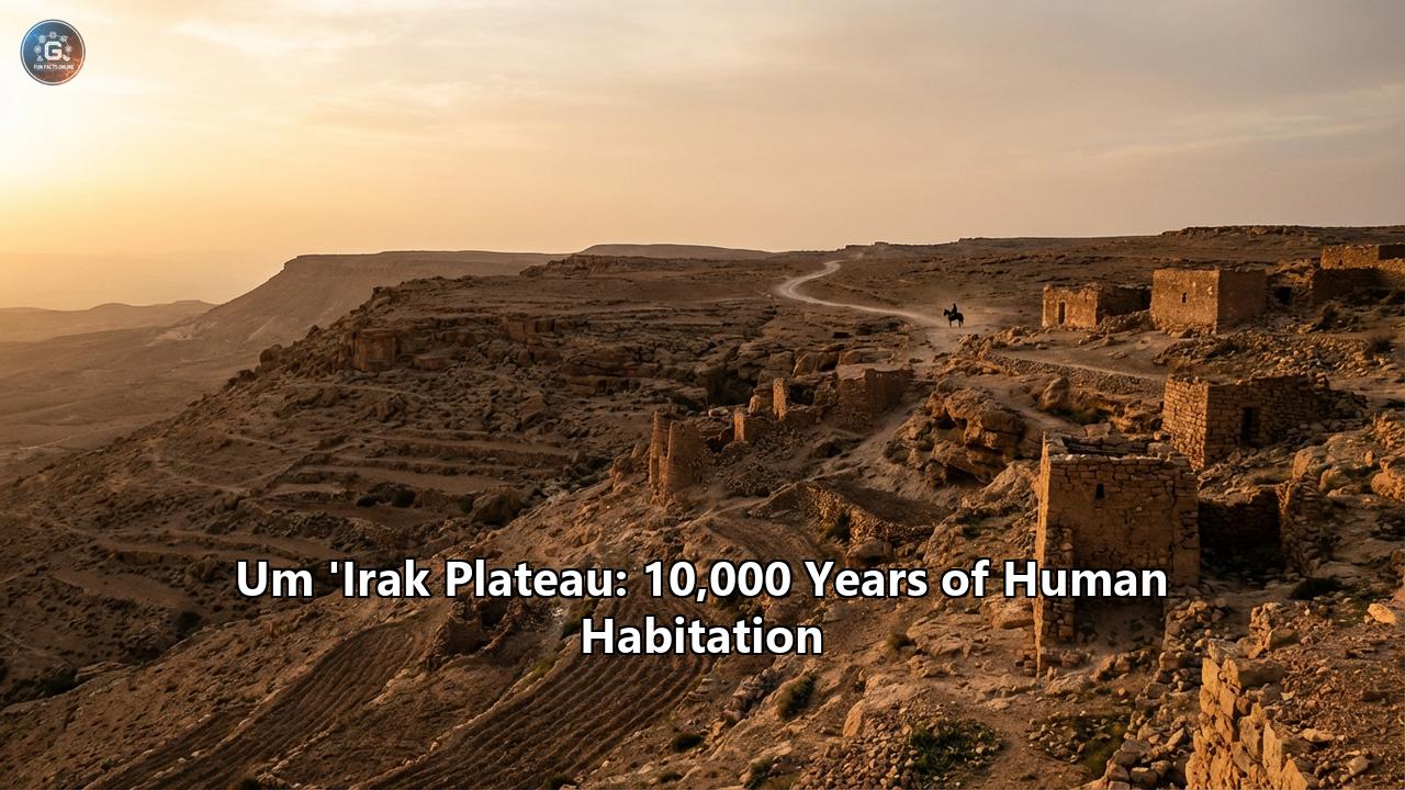
The Watchtower of the SinaiLocated approximately 5 kilometers northeast of the famous Temple of Serabit al-Khadim, the Um 'Irak Plateau rises as a strategic vantage point. Its elevation offers a commanding view of the Badiet el-Tih—the "Desert of the Wandering"—which stretches vast and flat to the north. To the south, the horizon is serrated by the peaks of the Sinai Massif, including Mount Sinai and Mount Saint Catherine.
This location is no accident of settlement. For a prehistoric hunter, it offered a lookout to spot game moving across the plains. For a Bronze Age miner, it was a landmark near the turquoise veins. For a Nabataean caravan driver, it was a waypoint on the treacherous journey between Petra and the Red Sea.
The Rock Shelter: Nature’s CanvasThe heart of the site is a massive, naturally formed sandstone rock shelter extending over 100 meters along the plateau’s eastern flank. Formed by wind erosion eating away at the softer layers of Paleozoic sandstone, the shelter provides a deep overhang—protection from the scorching summer sun and the biting winter winds.
The geology here is dominated by the Nubian Sandstone formation. This rock is crucial for two reasons:
- Water Retention: The porous sandstone acts as a natural aquifer, holding rainwater in rock pools (galt) long after the winter rains have ceased. This made the plateau a magnet for life in an otherwise dry landscape.
- Artistic Medium: The sandstone surfaces are smooth and coated with "desert varnish"—a dark patina of iron and manganese oxides. This created the perfect canvas for ancient artists. By scratching away the dark surface to reveal the lighter stone beneath (petroglyphs), or by applying pigments (pictographs) that bonded with the porous rock, they created images that have defied the elements for millennia.
II. The Green Dawn: The Epipaleolithic and Neolithic (10,000 – 5,500 BC)
The oldest layer of history at Um 'Irak transports us back to a world unrecognizable to the modern eye. 10,000 years ago, the Sinai was not a desert. It was a green steppe, teeming with life, watered by the monsoons of the Early Holocene Wet Phase.
The "Green Sinai" PhenomenonPaleoclimatologists refer to this era as the "African Humid Period." The Intertropical Convergence Zone (ITCZ) had shifted northward, bringing regular rainfall to the Sahara and Sinai. The wadis of Um 'Irak, now dry dust chutes, were once flowing rivers bordered by tamarisk and acacia trees. The plains of the Tih were covered in grasslands that supported herds of gazelle, ibex, wild ass, and even ostriches.
The Red Pigment PeopleThe most sensational find at the Um 'Irak rock shelter belongs to this era: a series of ceiling paintings executed in dark red ochre. Unlike the later "stick figure" art familiar in desert rock art, these paintings display a startling realism.
- The Fauna: The artists depicted the animals they shared their world with. Preliminary analysis suggests depictions of wild asses (Equus africanus) and ibex, painted with an attention to anatomical proportion that suggests a deep, intimate knowledge of the animals. These were not just food sources; they were fellow inhabitants of the green steppe.
- The Handprints: Scattered among the animals are handprints—negative stencils made by blowing pigment over a hand placed against the rock. This is a profoundly human signature. It is a statement of presence: "I was here. I touched this stone." It links the Um 'Irak site to a global tradition of cave art, from El Castillo in Spain to Sulawesi in Indonesia, yet it is rare to find such well-preserved examples in the open air of the Sinai.
Around 7,000 BC, the climate began to dry. The monsoons retreated south. The lush grasslands thinned into patchworks of vegetation. This environmental stress forced a change in human survival strategies. The hunter-gatherers of Um 'Irak began to adapt.
Archaeologists have identified stone partitions and hearth layers in the shelter dating to this transition period. These are the footprints of the Timnian Culture (named after the Timna Valley in the nearby Negev). The Timnians were among the world’s first pastoral nomads. They did not build permanent cities; they moved with their flocks of domesticated sheep and goats, following the seasonal grazing.
The rock art from this transitional phase shifts. We see the first depictions of domesticated animals. The chaotic, naturalistic hunting scenes give way to more orderly compositions. The "Grey Pigment" drawings—a unique feature of the Um 'Irak site—likely date to this period, representing a new artistic tradition using ash or charcoal-based mixtures, distinct from the earlier red ochre.
III. The Land of Turquoise: The Chalcolithic and Bronze Age (4,000 – 1,200 BC)
As the Neolithic gave way to the Chalcolithic (Copper Age) and the Bronze Age, the isolation of the Sinai ended. The Um 'Irak Plateau found itself on the periphery of the rise of Pharaonic Egypt.
The Copper ConnectionThe Sinai is rich in copper and turquoise. Just 5 kilometers southwest of Um 'Irak lies Serabit al-Khadim, the premier turquoise mining site of the ancient world. For the Egyptians, turquoise (mefkat) was the stone of joy and rebirth. To get it, they had to trek across the burning desert.
The Um 'Irak Plateau likely served as a forward scouting post or a seasonal camp for the local populations interacting with these Egyptian expeditions.
- Pottery Evidence: The 2026 excavations at Um 'Irak unearthed pottery shards dating to the Middle Kingdom (c. 2000 – 1700 BC). This confirms that the shelter was in use during the height of the Egyptian mining operations.
- The Local Perspective: While the Egyptians carved formal hieroglyphs at Serabit al-Khadim, the locals—the "Asiatics" or Retenu mentioned in Egyptian texts—left their own marks at Um 'Irak. The art from this period becomes more schematic. We see engravings of ibex with exaggerated horns, a symbol often associated with rain and fertility in desert cultures.
While no Proto-Sinaitic inscriptions (the ancestor of our alphabet) have been definitively announced at Um 'Irak in the initial reports, the site's proximity to Serabit al-Khadim is tantalizing. Serabit is where Canaanite miners, working for Egyptian overlords, first adapted hieroglyphs to write their own Semitic language—inventing the alphabet. The inhabitants of Um 'Irak were part of this same cultural milieu. It is highly probable that the "geometric signs" and enigmatic symbols found on the plateau walls are related to this intellectual leap, representing clan marks (wusum) or early attempts at literacy among the desert nomads.
IV. The Desert Highway: The Iron Age and Nabataean Period (1,000 BC – 106 AD)
By the first millennium BC, the camel had been domesticated. This single event revolutionized life in the Sinai. Suddenly, the deep desert was not a barrier, but a highway.
The Incense RouteThe Um 'Irak Plateau overlooks the Tih, a natural corridor connecting the Gulf of Aqaba to the Mediterranean. This became a secondary artery of the famous Incense Route, which carried frankincense and myrrh from Yemen to the ports of Gaza.
The rock art at Um 'Irak explodes with images of camels during this period. We see scenes of caravans: strings of camels led by riders, some carrying merchandise, others carrying warriors armed with lances and swords. These engravings are dynamic and action-oriented, reflecting a society where mobility and martial prowess were paramount.
The Nabataean PresenceThe Nabataeans, the Arab builders of Petra, were the masters of this trade network. Their influence saturated the Sinai.
- Inscriptions: The 2026 survey documented numerous Nabataean inscriptions at Um 'Irak. Written in their distinctive cursive Aramaic script, these are often graffiti left by travelers: "Remembered be [Name] son of [Name] for good."
- Sacred Spaces: The Nabataeans revered mountains and high places. The Um 'Irak Plateau, with its commanding view, may have served as a "high place" for ritual offerings to Dushara, the head of the Nabataean pantheon. The discovery of Roman-era pottery (specifically 3rd century AD) suggests that even after the Roman annexation of the Nabataean Kingdom in 106 AD, the site remained a hub of activity. The trade routes didn't stop; they just changed management.
V. The Age of Faith: Byzantine, Islamic, and Bedouin Layers (300 AD – Present)
As the classical world faded, the Sinai became a refuge for spiritual seekers.
The Monastic MovementDuring the Byzantine period (4th–7th centuries AD), the Sinai filled with Christian hermits seeking God in the silence of the wilderness. While the great Monastery of St. Catherine was built to the south, the Um 'Irak shelter likely hosted solitary anchorites. The cross symbols and perhaps some of the later Greek inscriptions found on the plateau testify to this Christian chapter.
The Islamic TransformationWith the arrival of Islam in the 7th century, the cultural orientation of the Sinai shifted once again. The rock art at Um 'Irak includes Kufic Arabic inscriptions, some of the earliest forms of Arabic writing. These often invoke the name of God (Allah) and ask for forgiveness.
- The Hajj Route: In later centuries, the Sinai became a land bridge for Muslim pilgrims traveling from Egypt and North Africa to Mecca. The Um 'Irak Plateau would have been a known landmark for these pious caravans.
- The Bedouin Legacy: The most recent layers of history belong to the Bedouin tribes of the Sinai—the Muzeina, the Aleygat, and the Sawalha. For them, Um 'Irak was not an archaeological site, but a living part of their territory (dirah).
Shelter: The soot-blackened ceiling of the cave is the result of countless Bedouin campfires lit over the last few centuries.
Tribal Marks: The walls are covered in wusum—tribal brands. These geometric symbols (circles, lines, crosses) were used to mark territory, ownership of wells, and to sign the rock itself.
Oral History: The discovery of the site by the archaeological mission was only possible due to the guidance of Sheikh Rabie Barakat of the local tribe. His knowledge proves that while the academic world had "lost" Um 'Irak, the locals never had. To them, it was always the "Mother of the Plateau," a place of ghosts and ancestors.
VI. The Significance of Um 'Irak: A Continuous Thread
The discovery of the Um 'Irak Plateau is being hailed as one of the most significant finds in Egyptian archaeology in decades. Why?
- Continuity: Most archaeological sites are snapshots of a single era—a Pharaonic temple, a Roman fort. Um 'Irak is a movie. It documents a continuous 10,000-year sequence of occupation. It shows us how the same* space was used differently by a Neolithic hunter, a Bronze Age miner, and an Islamic pilgrim.
- Climate Change Archive: The transition in rock art subjects—from water-loving ibex and wild asses to drought-tolerant camels—provides a visual record of the desertification of the Middle East. It is a warning from the past about the fragility of our ecosystems.
- The "Other" Egypt: It shifts the focus from the Nile Valley to the desert. It reminds us that the history of Egypt is not just the history of pyramids and farmers, but also of nomads, miners, and traders who lived on the margins but were central to the region's prosperity.
Conclusion: The Echoes of the Plateau
Today, the wind still howls over the Um 'Irak Plateau, just as it did 10,000 years ago. But now, the silence has been broken. The red-painted beasts of the Neolithic, the Nabataean prayers, and the Bedouin tribal marks have all been given a voice.
This site serves as a profound testament to the human spirit's adaptability. When the rains stopped, we didn't leave; we became herders. When the empires rose, we didn't vanish; we became traders. When the world changed, we wrote our names on the stone, ensuring that even if our bodies returned to the dust, our stories would endure. The Um 'Irak Plateau is not just a place on a map; it is a monument to the endurance of memory in the face of the eternal desert.
Reference:
- https://www.egyptindependent.com/new-archaeological-site-discovered-at-umm-arak-plateau-in-south-sinai/
- https://tvbrics.com/en/news/egypt-discovers-major-prehistoric-rock-art-site-in-south-sinai/
- https://www.mindat.org/loc-228179.html
- https://en.wikipedia.org/wiki/Serabit_el-Khadim
- https://the-past.com/review/travel/the-temple-of-hathor-at-serabit-el-khadim/
- https://greekreporter.com/2026/02/13/ten-thousand-years-history-new-site-sinai-egypt/