For centuries, the Western world looked at the Amazon rainforest and saw only a "Green Hell"—a pristine, impenetrable wilderness where humanity was but a fleeting guest. We were told the soil was too poor, the rains too relentless, and the jungle too consuming to ever support large-scale civilizations. We believed the indigenous populations were limited to small, nomadic tribes living lightly on the land, leaving no trace behind but broken pottery and charcoal.
We were wrong.
A revolution is taking place in the heart of the South American continent, driven not by machetes and pith helmets, but by laser pulses fired from the sky. The recent deployment of Lidar (Light Detection and Ranging) technology over the Upano Valley in eastern Ecuador has shattered our understanding of human history. It has revealed not just a few scattered ruins, but a sprawling, sophisticated agrarian metropolis that lay hidden beneath the canopy for 2,500 years. This is the story of the Amazonian Grid—a discovery that forces us to rewrite the textbooks and acknowledge the Amazon not as a trap for humanity, but as one of its great ancient cradles.
The Laser Eye in the Sky: Unveiling the Invisible
To understand the magnitude of this discovery, one must first understand the cloak of invisibility that has shrouded the Amazon for millennia. Traditional archaeology in the rainforest is a grueling, slow-motion battle. The vegetation is so dense that a researcher can stand ten feet from a monumental earthwork and not see it. Vines choke the view, roots distort the ground, and the sheer scale of the forest defies manual mapping.
Enter Lidar.
Imagine a plane flying low over the jungle, firing hundreds of thousands of laser pulses per second at the ground. Most of these pulses bounce off the leaves and branches of the canopy. But a tiny fraction—perhaps 1 or 2 percent—finds the gaps in the vegetation, travels all the way to the forest floor, and bounces back to the sensor on the plane.
By filtering out the "noise" of the trees, archaeologists can generate a 3D digital model of the bare earth. It is effectively a way to "digitally deforest" the Amazon without cutting down a single tree.
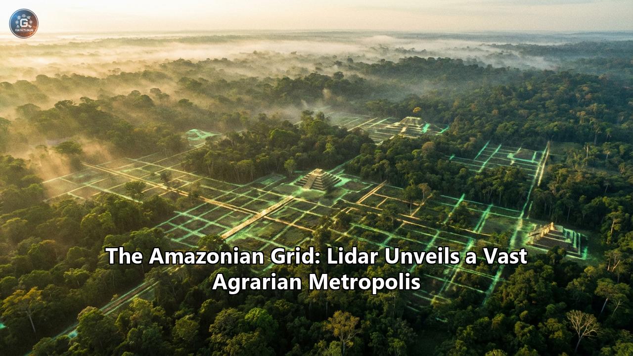
When Stéphen Rostain, a director of research at France’s National Center for Scientific Research (CNRS), and his team applied this technology to a 300-square-kilometer area of the Upano Valley in the Andean foothills, the results were not just surprising; they were staggering. The monitor did not show a chaotic jungle floor. It showed a grid. It showed geometry. It showed a landscape that had been almost entirely engineered by human hands.
The Garden Cities of the Upano
What Lidar revealed in the Upano Valley was a dense network of settlements that defies our standard definitions of "city" and "village." It is best described as "agrarian urbanism"—a low-density, spreading form of city-building that integrates living space with farming space.
The Platforms:The most immediate features to pop out of the 3D maps were rectangular earthen platforms. The team identified over 6,000 of them. These were not random mounds. They were engineered foundations, measuring roughly 20 meters by 10 meters (66 by 33 feet) and rising 2 to 3 meters high. They were built by scraping away the surrounding earth and piling it up to create dry, elevated surfaces for homes and ceremonial buildings—a crucial adaptation in a region prone to torrential rains and flooding.
The Clusters:These platforms were not isolated. They were organized into distinct clusters—neighborhoods, essentially. The researchers identified at least 15 major settlement sites, five of which are massive enough to be termed "cities." The largest of these, such as the site known as Kunguints, rivals the core area of the Mayan city of Tikal in size.
The Plazas:In the centers of these settlements, the platforms were arranged around large, open plazas. These were civic spaces, likely used for markets, rituals, and community gatherings. The geometry implies a complex social hierarchy and a central authority capable of planning and organizing labor on a massive scale.
The Grid: An Engineering Marvel
If the platforms were the "pixels" of this image, the road network was the circuitry that brought it to life. This is perhaps the most shocking aspect of the Upano discovery.
The Lidar scans revealed a vast, interlinked network of roads that is astonishingly straight. Unlike trails that meander around trees and hills, these roads were dug into the earth, often creating a sunken path flaked by elevated banks. They cut through the landscape with an engineer's obsession with straight lines and right angles.
- Connectivity: The roads did not just serve local neighborhoods. They stretched for tens of kilometers, connecting the major settlement clusters to one another. This suggests a unified society, or at least a federation of cooperating cities, rather than warring, isolated tribes.
- Scale: Some of these roads are up to 10 meters (33 feet) wide—comparable to a modern two-lane highway. The scale suggests they were not just footpaths but arteries for moving large numbers of people, goods, and perhaps ceremonial processions.
- Water Management: The engineering prowess extended to water. The region sits in the shadow of the Andes and receives significant rainfall. To manage this, the builders constructed extensive drainage canals and ditches alongside the roads and platforms. They terraformed the valley to control the flow of water, preventing their homes from flooding and irrigating their crops.
The "Green Urbanism" Concept
Why did we miss this for so long? Partly because it doesn't look like a European city. There are no stone walls, no cathedrals, no cramped, winding streets. This was a "Garden City."
In the Upano model, the urban fabric is woven into the agricultural one. The empty spaces between the platform clusters were not wilderness; they were farm fields. The Lidar showed evidence of field boundaries, drainage channels, and terracing.
This society, which thrived from roughly 500 BCE to 600 CE (contemporaneous with the Roman Empire), practiced a sophisticated form of agroforestry. They likely grew maize, manioc, sweet potatoes, and beans, while managing orchards of fruit and nut trees. They didn't clear the forest to build a city; they built their city out of the forest, using earth and timber instead of stone.
This reliance on biodegradable materials—earth, wood, palm thatch—is why the city "disappeared." When the civilization declined (likely due to volcanic activity from the nearby Sangay volcano, among other factors), the jungle reclaimed the wood and the rain eroded the earth. Without Lidar, all that remained visible to the naked eye were shapeless bumps on the forest floor.
Shattering the Pristine Myth
The implications of the Upano discovery extend far beyond archaeology. They strike at the heart of our environmental and historical philosophy.
For decades, the dominant theory was the "Counterfeit Paradise" hypothesis, popularized by archaeologist Betty Meggers in the 1970s. It argued that the Amazonian soil (laterite) was too acidic and nutrient-poor to support intensive agriculture, and thus, the region could only support small hunting-gathering bands.
The Upano discovery, along with other recent finds in the Brazilian Xingu and the Bolivian Llanos de Mojos, proves this environmental determinism wrong. Ancient Amazonians did not just adapt to their environment; they engineered it.
- Terra Preta: In other parts of the Amazon, indigenous people created Terra Preta (Dark Earth)—a man-made, charcoal-rich soil that is incredibly fertile and self-regenerating. While the Upano valley benefits from naturally fertile volcanic soil, the principle remains: these were active land managers, not passive inhabitants.
- Vindication of Oral History: This discovery also vindicates the accounts of the first European explorers. When Francisco de Orellana floated down the Amazon River in 1541, his chronicler Gaspar de Carvajal wrote of "gleaming white cities," glistening roads, and riverbanks "teeming with people." For centuries, historians dismissed Carvajal as a liar or a fantasist. The Lidar data suggests he may have been telling the truth. He saw the end of these civilizations before disease and conquest wiped them out.
A Pan-Amazonian Phenomenon
The Upano Valley is not an isolated anomaly. It is likely just the tip of the iceberg.
- Bolivia: In the Llanos de Mojos, Lidar has revealed the Casarabe culture (500–1400 CE), which built massive ceremonial pyramids and causeways that rise above the seasonally flooded savannas.
- Brazil: In the Upper Xingu, researchers have mapped "galactic polities"—networks of circular plaza villages connected by wide roads, dating back over a millennium.
Statistical models based on these Lidar samples suggest that we have uncovered less than 5% of the Amazon's archaeological heritage. There could be tens of thousands of undiscovered earthworks hidden in the "blank spots" on our maps.
The Future of the Past
The discovery of the Amazonian Grid is a race against time. The very technology that allows us to find these sites—satellite imagery and aerial scanning—also reveals the rapid encroachment of modern deforestation. Ranching, soy farming, and illegal mining are eating away at the rainforest, potentially destroying these ancient cities before we even know they are there.
Preserving these sites is not just about saving history; it is about saving the future. The ancient Upano people sustained a large population for over a thousand years without destroying their ecosystem. They practiced a form of urbanism that was integrated with nature, not opposed to it. As the modern world struggles with climate change and sustainable urbanization, the "Garden Cities" of the ancient Amazon may hold vital lessons on how to live with the forest, rather than against it.
Conclusion
The Amazon is not a wilderness. It is a heritage garden. The trees that stand today grow on the bones of a civilization that rivaled the complexity of the Maya and the grandeur of antiquity's great powers.
The Lidar scans of the Upano Valley have done more than map the ground; they have mapped a new reality. They have shown us that the "Green Hell" was once a bustling, engineered, and vibrant home to hundreds of thousands of people. The Amazonian Grid is a testament to human ingenuity, a ghost image of a lost world that is finally, after centuries of silence, coming into focus.
Reference:
- https://www.smithsonianmag.com/smart-news/this-ancient-city-has-been-hidden-in-the-amazon-for-2500-years-180983587/
- https://www.thebrighterside.news/post/researchers-uncover-ancient-network-of-cities-hidden-in-the-amazon-rainforest/
- https://archaeologymag.com/2024/01/laser-scans-reveal-ancient-cities-hidden-deep-in-the-amazon-rainforest/
- https://explorersweb.com/lost-city-amazon/
- https://www.youtube.com/watch?v=-ydFDpFnn4w
- https://www.youtube.com/watch?v=iK4OhygdrME
- https://www.zmescience.com/science/archaeology/lidar-amazon-ancient-cities/
- https://latinamericanpost.com/science-technology/revealing-amazon-secrets-with-lidar-to-transform-archaeology/
- https://www.theartnewspaper.com/2024/01/19/ecuador-amazonian-settlements-lidar-upano-valley
- https://www.youtube.com/watch?v=hTwnm_zHD9Q
- https://www.smithsonianmag.com/science-nature/lost-cities-of-the-amazon-discovered-from-the-air-180980142/
- https://www.ancient-origins.net/news-history-archaeology-ancient-places-americas/amazon-lidar-0021903
- https://news.mongabay.com/2025/10/indigenous-myths-reveal-amazons-past-truths-interview-with-stephen-rostain/
- https://www.livescience.com/archaeology/lasers-reveal-ancient-settlements-hidden-deep-in-the-amazon-rainforest
- https://dailygalaxy.com/2025/06/lidar-technology-unveils-2500-year-old-hidden-cities-in-the-amazon/
- https://www.google.com/search?q=time+in+Codaj%C3%A1s,+BR
- https://www.theguardian.com/global-development/2025/feb/06/ancient-garden-cities-amazon-indigenous-technologies-archaeology-lost-civilisations-environment-terra-preta