Martian Paleohydrology: Unveiling the 15,000km River Network of Ancient Mars
For centuries, the rust-hued plains of Mars have captivated the human imagination, a seemingly barren and desolate world. Yet, beneath its dusty veil lies a story of a dramatically different past, a tale of a planet once awash with water. This narrative, pieced together by decades of robotic exploration, has been spectacularly enriched by a recent discovery: a colossal, 15,000-kilometer network of ancient riverbeds etched into the Martian southern highlands. This intricate system of fossilized rivers, sprawling across a region known as Noachis Terra, provides some of the most compelling evidence to date of a sustained, water-rich climate on early Mars, challenging long-held theories and reinvigorating the search for ancient life.
A History of Discovery: The Evolving Picture of Water on Mars
The quest to understand Mars's watery past has been a long and incremental journey, each mission building upon the discoveries of its predecessors. The first tantalizing hints emerged in the early 1970s with NASA's Mariner 9 orbiter. After waiting out a planet-encircling dust storm, the spacecraft revealed images that were nothing short of revolutionary: features that looked remarkably like dried-up riverbeds and canyons, including the vast Valles Marineris system. For the first time, there was direct visual evidence that liquid had once sculpted the Martian surface.
This paradigm shift was further solidified by the Viking program in the mid-1970s. The Viking orbiters captured images of huge river valleys and vast outflow channels, suggesting cataclysmic floods had once burst forth from the ground. They also identified branched valley networks, particularly in the southern highlands, which strongly suggested the past occurrence of rainfall. The landers, for their part, analyzed soil samples and found that water was a component, and that the chemistry of the soil was consistent with having been exposed to water in the past.
Subsequent missions continued to add layers to this increasingly complex picture. The Mars Global Surveyor, which began mapping the planet in 1999, provided images of what appeared to be lakebeds and gullies that suggested more recent water flows. In the 2000s, the Mars Exploration Rovers, Spirit and Opportunity, landed on the surface and found definitive mineralogical evidence of past water, discovering rocks that had clearly been altered by it. The rovers confirmed that Mars was, at some point in its history, "drenched" with water. More recently, the Curiosity rover, exploring Gale Crater since 2012, has found evidence of what were likely habitable rivers and lakes, further cementing the understanding that Mars once hosted persistent liquid water.
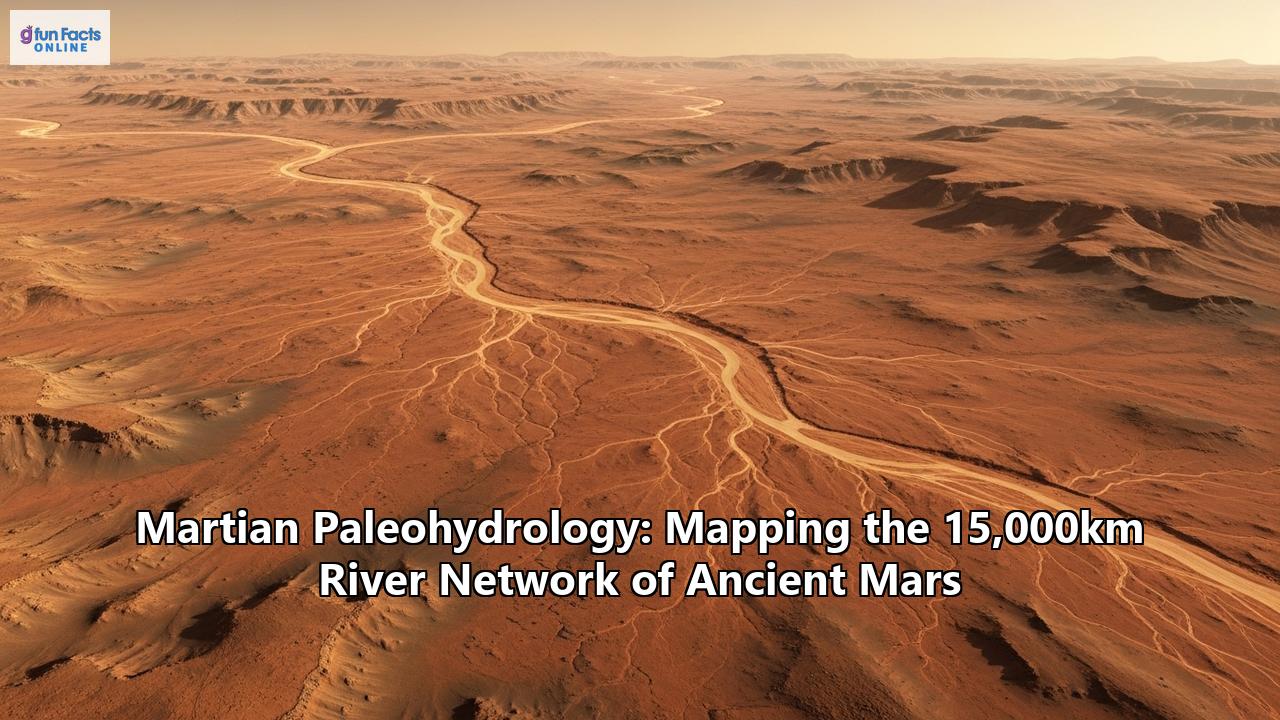
A River Network of Epic Proportions: The Noachis Terra Discovery
While the evidence for past water on Mars was substantial, the discovery of the 15,000-kilometer river network in Noachis Terra has provided a new scale to our understanding of the planet's ancient hydrology. This groundbreaking research, led by PhD student Adam Losekoot of the Open University, has reshaped our view of the Martian climate during the Noachian-Hesperian transition, around 3.7 billion years ago.
Noachis Terra, a vast and ancient highland region in the southern hemisphere of Mars, has historically been less studied for river networks compared to other regions. This is because it lacks the prominent, deeply incised valley networks that are often used as the primary indicator of past rainfall and runoff. Losekoot and his team took a different approach, focusing instead on a more subtle, yet equally revealing, type of geological feature: fluvial sinuous ridges (FSRs), also known as inverted channels.
Reading the Martian Landscape: The Science of Paleohydrology
Mapping ancient rivers on a distant world is a testament to the power of modern planetary science. Martian paleohydrology, the study of ancient water systems on Mars, relies heavily on data from orbiters, particularly NASA's Mars Reconnaissance Orbiter (MRO). This spacecraft, operational since 2006, is equipped with a suite of powerful instruments that allow scientists to study the Martian surface in unprecedented detail.
For the Noachis Terra study, researchers utilized data from three key instruments:
- The Context Camera (CTX), which provides wide-angle images that help scientists map the broader geological context of a region.
- The High Resolution Imaging Science Experiment (HiRISE), the most powerful camera ever sent to another planet, capable of capturing images with enough detail to see features as small as a rover on the surface. This allows for a close-up examination of the morphology of the riverbeds.
- The Mars Orbiter Laser Altimeter (MOLA) on the Mars Global Surveyor, which provides precise topographical data, allowing for the creation of detailed elevation maps.
By combining the imagery from CTX and HiRISE with the topographical data from MOLA, scientists can identify and map the FSRs that snake across the Martian landscape.
Fluvial Sinuous Ridges: Rivers in Reverse
Fluvial sinuous ridges are a fascinating geological phenomenon. They are the fossilized remains of ancient rivers, but they appear as raised ridges rather than channels. This "inversion" of the topography happens through a specific geological process.
Imagine a river flowing across the Martian surface billions of years ago. It carries with it sand, gravel, and other sediments. These materials are deposited on the riverbed. Over time, these sediments can become cemented together, forming a hard, erosion-resistant rock. The surrounding terrain, however, may be composed of softer, finer-grained material.
As the Martian climate changed and the rivers dried up, wind became the dominant erosional force. The relentless Martian winds gradually stripped away the softer surrounding material, leaving the more resistant, cemented riverbed deposits standing as a winding, elevated ridge. In essence, we are seeing the ghost of a river, preserved in stone and standing proud of the surrounding plains.
These FSRs are not unique to Mars; they are also found on Earth in places like central Utah, providing an excellent analogue for study. By comparing the Martian FSRs to their terrestrial counterparts, scientists can infer details about the ancient Martian rivers, such as their size and how they migrated over time.
A New Climate Paradigm for Ancient Mars?
The discovery of the extensive and interconnected river network in Noachis Terra has profound implications for the long-standing debate about Mars's ancient climate. For years, the scientific community has been divided between two main competing theories:
- The "warm and wet" model, which proposes that early Mars had a thicker atmosphere and a warmer climate, allowing liquid water to be stable on the surface for long periods. This would have supported an active hydrological cycle with rainfall and persistent rivers.
- The "cold and icy" model, which suggests that early Mars was generally cold and dry, with most of its water locked up as ice. In this scenario, liquid water would have only appeared sporadically, perhaps due to volcanic eruptions or asteroid impacts that melted the ice, creating massive but short-lived floods.
The evidence from Noachis Terra lends significant weight to the "warm and wet" hypothesis. The sheer scale of the 15,000-kilometer river network, with its interconnected systems and evidence of meandering channels, suggests that water flowed for a geologically significant period. Some of the ridges rise tens of meters above the surrounding terrain, indicating that the rivers were active for a long time, depositing substantial amounts of sediment. The widespread distribution of these features also points to precipitation as the likely source of the water, rather than localized melting events.
These findings challenge the notion that Mars was a mostly cold and dry world with only brief, catastrophic floods. Instead, they paint a picture of a planet with a more stable and complex climate, capable of supporting long-lived river systems.
The Ultimate Question: Implications for Ancient Life
The presence of long-lived rivers on ancient Mars inevitably raises the tantalizing question of whether the planet could have once harbored life. Water is the one essential ingredient for life as we know it, and the discovery of ancient river systems and lakebeds makes Mars a prime target in the search for extraterrestrial life.
River corridors on Earth are hotspots of biological activity, providing not only water but also concentrating nutrients and organic molecules. The rivers of Noachis Terra would have created similar habitable environments on ancient Mars. If life did arise on the Red Planet, the sedimentary rocks deposited by these ancient rivers are the most likely places to find evidence of it in the form of biosignatures.
The Perseverance rover is currently undertaking a similar search in Jezero Crater, which is believed to be an ancient lakebed fed by a river delta. The rover is collecting rock samples that will be returned to Earth by a future mission, where they can be analyzed in sophisticated laboratories for signs of past microbial life. The discovery of the massive river network in Noachis Terra suggests that such potentially habitable environments may have been even more widespread on ancient Mars than previously thought.
The Unfolding Story of a Watery Past
The mapping of the 15,000-kilometer river network in Noachis Terra is a landmark achievement in the field of Martian paleohydrology. It is a powerful reminder that Mars, our celestial neighbor, was not always the cold, arid world we see today. The winding ridges that crisscross its ancient highlands are silent storytellers, preserving a record of a time when rivers flowed, a time when the Red Planet may have been a much more vibrant and dynamic world. As our exploration of Mars continues, with ever more advanced orbiters and rovers, we will undoubtedly uncover more chapters in this epic tale, bringing us closer to understanding the full story of Mars's watery past and, perhaps, to answering one of humanity's most profound questions: are we alone in the universe?
Reference:
- https://marspedia.org/Rivers_on_Mars
- https://www.open.edu/openlearn/science-maths-technology/the-search-water-on-mars/content-section-5.1
- https://en.wikipedia.org/wiki/Chronology_of_discoveries_of_water_on_Mars
- https://en.wikipedia.org/wiki/Viking_2
- https://www.amnh.org/explore/videos/space/geologists-water-mars
- https://www.jpl.nasa.gov/news/nasa-images-suggest-water-still-flows-in-brief-spurts-on-mars/
- https://time.com/4052396/water-mars-history/
- https://astrobiology.arizona.edu/news/curiosity-rover-finds-new-evidence-ancient-mars-rivers-key-signal-life
- https://ntrs.nasa.gov/api/citations/20190001068/downloads/20190001068.pdf
- https://astrobiology.com/2025/07/ancient-river-systems-reveal-mars-was-wetter-than-we-thought.html
- https://www.lpi.usra.edu/meetings/earlymars2012/reprintLibrary/Baker_2009.pdf
- https://science.nasa.gov/mission/mars-reconnaissance-orbiter/science-instruments/
- https://en.wikipedia.org/wiki/Noachian
- https://www.sciencealert.com/the-oldest-evidence-for-water-on-mars-reveals-it-was-extremely-hot
- https://www.cbsnews.com/news/nasa-evidence-of-recent-water-on-mars/
- https://www.universetoday.com/articles/ancient-rivers-in-noachis-terra-reveal-mars-long-lived-wet-past
- https://www.brown.edu/news/2017-10-17/icyhighlands
- https://seas.harvard.edu/news/2015/06/unveiling-ancient-climate-mars
- https://www.numberanalytics.com/blog/geology-martian-water-astrobiology
- https://astrobiology.nasa.gov/news/water-on-mars-the-story-so-far/
- https://astrobiology.com/2023/07/an-ancient-riverbed-on-mars-is-helping-perseverance-do-its-work.html