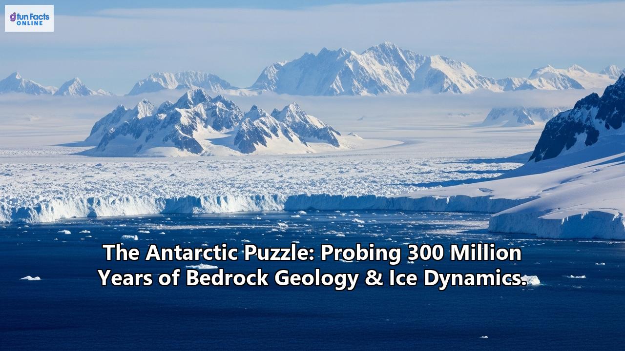
Beneath a formidable shield of ice, averaging over two kilometers thick, lies a continent of untold geological secrets and dynamic processes that have shaped our planet for hundreds of millions of years. Antarctica, a realm of extreme cold and breathtaking desolation, holds the key to understanding profound shifts in Earth's climate, the assembly and breakup of supercontinents, and the intricate dance between solid earth and vast, moving ice masses. Probing its ancient bedrock and the overlying, ever-shifting ice is like assembling a colossal, three-dimensional puzzle, with each new discovery revealing another piece of a story stretching back at least 300 million years, and often far beyond.
A Continent's Ancient Roots: Antarctica's Bedrock Geology
Antarctica's geological history is a sprawling epic, deeply intertwined with the planet's grand tectonic narratives. It wasn't always the isolated, ice-covered landmass we see today. For vast stretches of geological time, it was a pivotal part of ancient supercontinents. Around 300 million years ago, during the late Paleozoic Era, Antarctica was nestled within Gondwana, a colossal landmass that also included present-day South America, Africa, India, and Australia. Gondwana itself was a major component of the even larger supercontinent, Pangea. The rocks of Antarctica bear the imprint of these ancient connections and the fiery rifting events that eventually tore these supercontinents apart, sending Antarctica on its solitary journey towards the South Pole.
Geologically, Antarctica is broadly divided into two distinct provinces, separated by the iconic Transantarctic Mountains: the vast, ancient craton of East Antarctica and the mosaic of younger, accreted terranes that make up West Antarctica.
East Antarctica: The Ancient ShieldEast Antarctica is the larger and older of the two, a Precambrian shield composed of rocks dating back over 3 billion years in some places. This cratonic core has been a stable block for a significant portion of Earth's history, though its margins have been affected by later tectonic events. Beneath the massive East Antarctic Ice Sheet lie hidden mountain ranges and vast basins, relics of its protracted evolution.
West Antarctica: A More Dynamic YouthIn contrast, West Antarctica is a geological youngster, comprising several smaller crustal blocks or terranes that were welded together over the past 500 million years. This region is characterized by the West Antarctic Rift System, a massive zone of crustal extension, comparable in scale to the Basin and Range Province of North America or the East African Rift. This rifting, which has been active from the Cretaceous period to the present day, has resulted in significant crustal thinning, volcanic activity, and the formation of deep subglacial basins, some of which lie more than 2.5 kilometers below sea level. The geology of West Antarctica, particularly its low-lying bedrock, plays a crucial role in the stability of the West Antarctic Ice Sheet.
Majestic Mountains: Seen and UnseenThe Transantarctic Mountains, one of the longest mountain ranges on Earth, stretch for over 3,500 kilometers across the continent, forming a spectacular barrier between East and West Antarctica. These peaks, some rising above 4,500 meters, offer a glimpse into the continent's bedrock, revealing a complex history of uplift and erosion. Recent research analyzing igneous rocks from these mountains suggests a dynamic landscape history with multiple mountain-building and erosion events, including evidence supporting a significant glacial period around 300 million years ago.
Entirely hidden beneath kilometers of ice in East Antarctica lie the Gamburtsev Subglacial Mountains. Discovered by a Soviet expedition in 1958, these mountains are comparable in scale to the European Alps, yet their existence in the tectonically stable interior of East Antarctica was a major puzzle. Studies involving radar and analysis of zircon grains (tiny mineral "time capsules") carried by ancient rivers suggest these mountains first rose over 500 million years ago during the formation of Gondwana. They reached Himalayan heights before being largely eroded, then experienced a later rejuvenation before the ice sheets entombed them, preserving their alpine topography. The Gamburtsev range is thought to have been a key nucleation point for the East Antarctic Ice Sheet.
From Lush Forests to Deep Freeze: A 300-Million-Year Climatic JourneyAround 300 million years ago, during the Permo-Carboniferous period, despite Gondwana's proximity to the South Pole, evidence of widespread glaciation is found not only in Antarctica but also in South America, Africa, India, and Australia. This ancient ice age left its mark on the bedrock in the form of glacial deposits and striations. However, Antarctica wasn't always icy. Fossil evidence of forests, including the seed-fern Glossopteris, found in the Transantarctic Mountains, demonstrates that the continent experienced much warmer climates in its distant past, even when it was in a polar position. The journey from these temperate, and at times even tropical, conditions to its current frozen state is a tale of continental drift, changing ocean currents, and declining atmospheric carbon dioxide levels.
The Birth and Evolution of Antarctica's Ice Sheets
The transition to a fully glaciated Antarctica was a protracted process, driven by global Cenozoic cooling that began roughly 50 million years ago. Key milestones in this deep freeze include:
- The Late Eocene (around 34-37 million years ago): Mountain glaciation began to appear, coinciding with the glaciation of other parts of the continent. This cooling was accompanied by a decrease in the diversity of plant life.
- The Eocene-Oligocene Boundary (around 34 million years ago): This marks the first widespread glaciation of Antarctica and the initial formation of a continental-scale ice sheet, primarily in East Antarctica. This major climate shift is linked to declining atmospheric CO2 concentrations and tectonic events.
- The Opening of Ocean Passageways: The separation of Antarctica from Australia and South America (forming the Drake Passage) led to the establishment of the Antarctic Circumpolar Current. This powerful current isolated Antarctica thermally, intensifying its cooling.
- The Miocene (around 23 to 5.3 million years ago): The East Antarctic Ice Sheet (EAIS) largely stabilized, while the West Antarctic Ice Sheet (WAIS) began to develop, experiencing periods of growth and collapse. By the middle Miocene (around 14 million years ago), a more dynamic, polythermal ice sheet was in place. The Gamburtsev Subglacial Mountains are thought to have been a crucial high-altitude area for the initial growth of the EAIS.
- Pliocene and Quaternary (last 5.3 million years to present): The ice sheets, particularly the WAIS and the Antarctic Peninsula Ice Sheet, continued to fluctuate significantly, advancing onto the continental shelf during glacial periods and retreating during interglacials. The Antarctic Peninsula is considered one of the last regions to become fully glaciated.
Evidence for these dramatic climatic and glacial shifts comes from deep-sea sediment cores, which record changes in oxygen isotopes (a proxy for ice volume and temperature), as well as from direct geological sampling around the Antarctic margin and, more recently, from beneath the ice itself.
Peering Beneath the Ice: Methods of Discovery
Unraveling Antarctica's subglacial secrets is a monumental challenge, requiring innovative technologies and ambitious scientific expeditions.
- Indirect Geophysical Methods:
Ice-penetrating radar (IPR): This has been a revolutionary tool, allowing scientists to "see" through the ice to map the bedrock topography, identify subglacial lakes, and trace internal ice layers.
Seismic surveys: Similar to IPR, seismic waves are used to image the rock layers beneath the ice, providing details about geological structures and sediment thickness.
Satellite altimetry: Precisely measures the ice surface elevation, revealing the subtle dips and rises that can indicate underlying mountains, basins, and even the filling and draining of subglacial lakes.
Gravity and magnetic surveys: These help to infer the density and composition of the rocks hidden beneath the ice, identifying different geological provinces and structures like rift valleys.
- Direct Sampling and Drilling:
Geological drilling projects: Initiatives like the Antarctic Geological Drilling (ANDRILL) program and the International Ocean Discovery Program (IODP) have retrieved sediment cores from the Antarctic margin and beneath the Ross Ice Shelf. These cores provide invaluable records of past ice sheet behavior, climate, and sea-level changes.
Subglacial lake access: One of the most exciting frontiers is the exploration of subglacial lakes. After decades of planning and technological development, scientists have successfully drilled into several of these hidden water bodies, including Lake Whillans and Mercer Subglacial Lake in West Antarctica, and the massive Lake Vostok in East Antarctica (though Vostok sampling faced contamination issues). The SALSA (Subglacial Antarctic Lakes Scientific Access) project, for instance, bored through nearly 1.2 kilometers of ice to sample Mercer Subglacial Lake, discovering a surprisingly rich microbial ecosystem and sediments that offer clues to past ice sheet stability.
- Laboratory Analyses:
Recovered rock and sediment samples undergo meticulous analysis. Zircon geochronology (dating zircon crystals using uranium-lead decay) helps determine the age of rocks and reconstruct ancient mountain-building events.
Isotope geochemistry (analyzing ratios of different isotopes of elements like oxygen, carbon, and strontium) provides information about past temperatures, carbon cycling, and weathering processes.
* Microfossil analysis (studying tiny fossils of ancient organisms) in sediment cores helps reconstruct past environmental conditions and date the sediments.
The Dynamic Dance: Interaction Between Bedrock and Ice
The relationship between Antarctica's bedrock and its overlying ice sheets is a complex and dynamic one, with the geology profoundly influencing how the ice flows and responds to climate change.
- Bedrock Topography's Guiding Hand: The shape of the land beneath the ice dictates the pathways of ice flow, channeling it into fast-flowing ice streams that transport vast quantities of ice towards the ocean. The presence of deep basins, particularly in West Antarctica where much of the bedrock lies below sea level, makes the ice sheet more vulnerable to incursions of warm ocean water, which can accelerate melting at the grounding line (where the ice starts to float). The roughness or smoothness of the bedrock also affects the friction at the base of the ice, influencing its speed.
- Subglacial Lakes: More Than Just Water: The discovery of over 675 subglacial lakes beneath the Antarctic ice, ranging from small ponds to vast bodies like Lake Vostok (one of the largest lakes on Earth), has transformed our understanding of the subglacial environment. These lakes are not static; many are part of an active hydrological system, with water filling and draining between them. This subglacial plumbing can lubricate the base of the ice sheet, influencing ice flow speeds and potentially destabilizing sections of the ice. These isolated environments also harbor unique microbial ecosystems that have been cut off from the atmosphere for millions of years, offering insights into the limits of life on Earth and potentially other icy worlds. Drilling into these lakes has provided samples of sediment that can reveal the history of the ice sheet and the lakes themselves.
- Geothermal Heat Flux: A Hidden Warmth: Heat flowing from the Earth's interior, known as geothermal heat flux, can melt the base of the ice sheet, contributing to the formation of subglacial water and influencing ice rheology. While generally low across much of Antarctica, areas with higher geothermal heat, such as the volcanic regions of the West Antarctic Rift System, can have a more significant local impact on basal conditions and ice dynamics.
- Isostatic Rebound: The Rising Land: As ice sheets melt and their immense weight is removed, the underlying bedrock slowly rebounds or uplifts. This process, called glacial isostatic adjustment, is happening in Antarctica today. Recent studies suggest that this land uplift can be surprisingly rapid and could play a significant role in future sea-level rise by altering the stability of the ice sheet at the grounding line. Under scenarios of slowed global warming, uplift could potentially reduce Antarctica's contribution to sea-level rise, but under high emissions scenarios, rapid ice retreat might outpace uplift, exacerbating sea-level rise.
The Antarctic Puzzle and Our Changing World
Understanding the 300-million-year interplay between Antarctica's bedrock geology and its ice dynamics is not just an academic pursuit; it is crucial for comprehending the continent's response to current and future climate change.
- Vulnerable Giants: Thwaites and Pine Island Glaciers: The Thwaites Glacier in West Antarctica, often dubbed the "Doomsday Glacier," and its neighbor, the Pine Island Glacier, are among the most closely watched and rapidly changing ice masses on the planet. Both glaciers flow over bedrock that deepens inland and lies below sea level, making them highly susceptible to the marine ice sheet instability mechanism. Warm ocean water is infiltrating beneath their floating ice shelves and even reaching their grounding lines, accelerating melt from below. The geological setting – the shape of the bedrock, the presence of subglacial water, and geothermal heat – all contribute to their alarming retreat. The potential collapse of Thwaites Glacier alone could raise global sea levels by over half a meter, and it acts as a plug for a much larger area of the West Antarctic Ice Sheet.
- Informing Future Projections: By studying how Antarctic ice sheets responded to past warm periods and changes in bedrock conditions, scientists can improve the computer models used to project future ice sheet behavior and sea-level rise. Understanding the sensitivity of different regions of the ice sheet to factors like ocean warming and bedrock topography is critical for making reliable predictions. For instance, knowing the error margins in bedrock topography maps is crucial for reducing uncertainty in sea-level rise projections from glaciers like Thwaites.
- Unanswered Questions and Future Research: Despite remarkable progress, many pieces of the Antarctic puzzle remain missing. What are the precise conditions beneath vast, unexplored areas of the ice sheet? How interconnected are the subglacial hydrological systems? How quickly can the bedrock respond to ice unloading, and what are the full implications for ice stability? Continued exploration using advanced remote sensing, more extensive drilling into both the bedrock and subglacial environments, and sophisticated numerical modeling are essential to answer these questions. Projects aim to unravel the deep history of regions like the Nimrod Complex in East Antarctica to better understand crustal evolution and its links to supercontinent cycles and ice sheet stability. Chinese scientists recently discovered 46 new subglacial lakes, highlighting how much there is still to learn.
A Frozen Continent with a Fiery Past and an Uncertain Future
Antarctica's bedrock geology, forged over hundreds of millions of years through continental collisions, rifting, and volcanic activity, provides the fundamental template upon which its immense ice sheets have grown and evolved. The dynamic interplay between this ancient, hidden landscape and the overlying ice has shaped the continent's past and will critically influence its future – and, consequently, the future of global sea levels and climate. As scientists continue to probe deeper beneath the ice, each new discovery helps to complete the Antarctic puzzle, revealing not just the secrets of a frozen continent, but also vital clues about the workings of our entire planet in an era of unprecedented change.
Reference:
- https://www.umweltbundesamt.de/en/geology-of-the-antarctic
- https://discoveringantarctica.org.uk/oceans-atmosphere-landscape/ice-land-and-sea/tectonic-history-into-the-deep-freeze/
- https://www.lyellcollection.org/doi/10.1144/sp383.9
- https://www.britannica.com/place/Pangea
- https://en.wikipedia.org/wiki/Antarctic_plate
- https://en.wikipedia.org/wiki/Pangaea
- https://en.wikipedia.org/wiki/East_Antarctic_Shield
- https://rjes.wdcb.ru/v04/tje02099/tje02099.htm
- https://www.bas.ac.uk/data/our-data/publication/the-geological-history-and-evolution-of-west-antarctica/
- https://nora.nerc.ac.uk/id/eprint/525073/
- https://en.wikipedia.org/wiki/West_Antarctic_Rift_System
- https://www.usgs.gov/publications/west-antarctic-rift-system-a-propagating-rift-captured-a-mantle-plume
- https://pubs.geoscienceworld.org/gsa/geosphere/article/14/6/2407/565649/Geodynamic-models-of-the-West-Antarctic-Rift
- https://www.royalsociety.org.nz/research/warming-seas-vs-frozen-continent/
- https://axa-research.org/funded-projects/climate-environment/ice-sheet-instability-is-all-of-west-antarctica-at-risk
- https://scitechdaily.com/a-300-million-year-puzzle-researchers-uncover-new-clues-to-antarcticas-mysterious-bedrock/
- https://indiandefencereview.com/scientists-uncover-a-lost-world-hidden-beneath-antarcticas-frozen-tapestry-for-millions-of-years/
- https://thedebrief.org/scientists-reveal-new-clues-about-ancient-lost-world-hidden-beneath-the-ice-of-antarctica/
- https://www.utas.edu.au/about/news-and-stories/articles/2025/antarctica-has-a-huge,-completely-hidden-mountain-range.-new-data-reveals-its-birth-over-500-million-years-ago
- https://www.shankariasparliament.com/current-affairs/gamburtsev-subglacial-mountains
- https://en.wikipedia.org/wiki/Gamburtsev_Mountain_Range
- https://www.britannica.com/place/Gamburtsev-Mountains
- https://www.iflscience.com/a-giant-mountain-range-has-been-hidden-under-antarcticas-ice-for-millions-of-years-79186
- https://www.geolsoc.org.uk/Plate-Tectonics/Chap1-Pioneers-of-Plate-Tectonics/Alfred-Wegener/Glacial-Deposits-from-Permo-Carboniferous-Glaciation.html
- https://www.sciencedaily.com/releases/2010/02/100223154346.htm
- https://www.pnas.org/doi/10.1073/pnas.1014885108
- https://royalsocietypublishing.org/doi/10.1098/rsta.2014.0301
- https://epic.awi.de/id/eprint/40459/
- https://www.antarcticglaciers.org/glacial-geology/antarctic-ice-sheet/icesheet_evolution/
- http://www.essc.psu.edu/essc_web/publications/PDFs/ant_heatflux.pdf
- https://www.bas.ac.uk/media-post/the-dawn-of-the-antarctic-ice-sheets/
- https://www.mdpi.com/2073-4441/16/8/1111
- https://en.cug.edu.cn/info/1228/3483.htm
- https://epic.awi.de/id/eprint/41923/1/assessing-the-subglacial-lake-coverage-of-antarctica.pdf
- https://scripps.ucsd.edu/news/researchers-extract-first-layered-lake-sediment-sample-subglacial-antarctica
- https://salsa-antarctica.org/
- https://cmr.earthdata.nasa.gov/search/concepts/C3386889634-AMD_USAPDC.html
- https://issm.jpl.nasa.gov/news/index.cfm?FuseAction=ShowNews&NewsID=72
- https://greenly.earth/en-gb/blog/ecology-news/what-is-the-doomsday-glacier-and-why-does-it-matter
- https://noco2.com.au/blog/what-to-know-about-thwaites-glacier/
- https://thwaitesglacier.org/news/hidden-lakes-threaten-stability-antarctic-ice-shelves
- https://www.preventionweb.net/news/how-rising-earth-antarctica-will-impact-future-sea-level-rise
- https://egusphere.copernicus.org/preprints/2024/egusphere-2024-2982/egusphere-2024-2982.pdf
- https://en.wikipedia.org/wiki/Thwaites_Glacier
- https://www.cambridge.org/core/journals/annals-of-glaciology/article/modelling-the-longterm-response-of-the-antarctic-ice-sheet-to-global-warming/B89893D35BC9A9994DA5490C4ECDD7E5
- https://scar-iasc.de/en/ice-sheet-dynamics/
- https://www.pnas.org/doi/10.1073/pnas.1205385109