Beneath the Waves: Uncovering the Sunken Giants of the North Sea
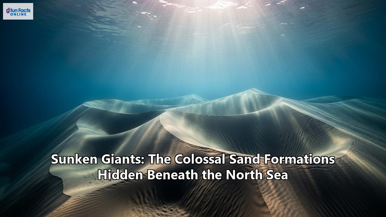
Far below the churning, grey surface of the North Sea, hidden from the ships that ply its busy lanes and the rigs that harvest its energy, lies a breathtaking and dynamic landscape. This is not a static world of mud and rock, but a realm of colossal underwater deserts, sculpted into vast fields of gigantic, shifting sand dunes. Known to scientists as sandwaves, these sunken giants are among the largest and most active on the planet, some towering as high as a five-story building and stretching for nearly a kilometer from crest to crest. They are the colossal, slow-breathing lungs of the seabed, constantly moving, reshaping the seafloor, and posing a formidable, often invisible, challenge to the immense human enterprise that operates above. This is the story of the North Sea's hidden sand formations: how they are born from the powerful dance of tides, why they are crucial oases of life, and how humanity is learning to navigate and build around these magnificent, migratory wonders.
A World in Motion: The Architecture and Scale of Seabed Giants
The floor of the North Sea, particularly in its shallower southern regions, is not a flat, featureless plain. Instead, vast areas are covered by these rhythmic, undulating bedforms. Early mariners, using lead lines to gauge depth, were the first to get hints of this strange topography, calling them "ridges" or "humps" that could unexpectedly snatch at their lines. Fishermen, too, have long been familiar with these "ridens" or "ongelijkens" (irregularities) that snagged their nets. However, it was not until the advent of echo-sounding technology in the 1930s that the true scale and prevalence of these features began to be understood.
Pioneering work by Dutch engineer Jon van Veen in the 1930s, using early echo-sounders, produced the first graphical profiles of these "submarine sand dunes." His charts revealed wave-like structures for miles on end, with sharp crests and immense proportions. He recorded sandwaves reaching heights of 10 to 13 meters (33 to 43 feet) and lengths of about 200 meters (220 yards).
Modern survey technology, particularly multibeam echosounders, has since painted a far more detailed picture. These systems sweep the seafloor with a fan of sound beams, creating high-resolution 3D maps that reveal the staggering complexity of these sandwave fields. Today, we know that sandwaves are a ubiquitous feature of sandy continental shelves with strong tidal currents. In the North Sea, their wavelengths—the distance from one crest to the next—can range from one hundred to one thousand meters, though they most commonly fall between 200 and 700 meters. Their heights are equally impressive, capable of reaching up to half the water depth in some areas. In a 40-meter deep channel, this could mean a sandwave 20 meters high, a truly colossal structure that dramatically alters the local seascape.
These are not static mounds. The sandwaves of the North Sea are in constant, albeit slow, motion. Driven by the prevailing currents, they migrate across the seabed. Typical migration rates on the continental shelf off the Netherlands are between 0 and 3 meters per year. However, where tidal currents are stronger or more asymmetrical, this rate can increase to tens of meters annually. Case studies in wind farm development areas have recorded movements of isolated features of up to 155 meters in just five years, highlighting the immense dynamism of this environment.
Furthermore, these giants are not solitary creatures. They are often adorned with smaller, superimposed bedforms. On their vast, sloping flanks, smaller "megaripples" can form, themselves several meters high. These, in turn, can be covered by even smaller ripples, creating a complex, multi-layered hierarchy of bedforms, all moving and evolving at different timescales. This entire system is in a perpetual state of flux, governed by the powerful forces of the sea.
The Engine of Creation: How Tides and Storms Sculpt the Seafloor
The formation of these colossal sandwaves is a captivating example of what scientists call "spontaneous bedform generation." It is a process born from an intricate feedback loop between the moving water and the sandy seabed. It all begins with the relentless, powerful pulse of the North Sea's tides.
For sandwaves to form, the tidal currents must be strong enough to pick up and move sand particles from the seabed. Once this threshold is met, any small, random irregularity on the seafloor—a slight bump or depression—can trigger their growth. As the tide flows over this initial bump, the water motion is subtly perturbed. This perturbation creates what are known as "residual circulation cells"—a faint, tidally-averaged vertical movement in the water column. These cells generate a near-bed flow that moves from the troughs (the low points) towards the crests (the high points).
This flow carries sand particles up the slope of the bump. At the same time, gravity works to pull the particles back down. However, if the tidally-induced transport is strong enough to overcome gravity, more sediment is deposited on the crest than is removed. The bump begins to grow. As it grows, it perturbs the flow even more, which in turn strengthens the circulation cells, which transports more sediment to the crest. This mutually reinforcing process causes the initial small irregularity to grow into a towering sandwave.
The shape and behavior of the sandwave are dictated by the nature of the tidal currents. If the flood and ebb tides are perfectly symmetrical in strength and duration, the sandwave will also be symmetrical, with gentle slopes on both sides, and it will remain largely stationary. However, in most parts of the North Sea, the tides are asymmetrical. One tide (either the flood or the ebb) is typically stronger or lasts longer than the other. This imbalance breaks the symmetry. The stronger current pushes more sediment up one side (the "stoss" slope) than the other. Sand grains are driven up the gentle stoss slope and then cascade down the steeper "lee" slope, causing the entire sandwave to migrate in the direction of the dominant current. This gives the sandwave its characteristic asymmetric profile, with a gentle upstream slope and a steeper downstream face.
While tides are the primary architects, storms are the powerful modifiers of this underwater landscape. During a storm, strong winds generate powerful surface waves and drive currents. The orbital motion of the waves can reach the seabed even in relatively deep water, stirring up vast quantities of sediment. This intense energy tends to have a flattening effect, reducing the height of sandwaves. Simultaneously, the strong, wind-driven currents can dramatically accelerate sandwave migration, or even temporarily reverse its direction. One study concluded that the effect of a single storm on sandwave movement can be equivalent to 20 years of calm, fair-weather conditions. This interplay between the steady, rhythmic construction by tides and the episodic, violent reshaping by storms defines the life cycle of these sunken giants.
Oases in the Desert: The Surprising Biodiversity of Sandwave Fields
At first glance, a windswept desert of mobile sand seems an inhospitable place for life. The constant movement of sediment and the strong currents create a physically demanding environment. Yet, these sandwave fields are far from barren wastelands; they are complex, three-dimensional habitats that support a surprisingly rich and diverse array of marine life. They function as biodiversity hotspots on the otherwise relatively uniform sandy plains of the North Sea floor.
The key to their ecological success lies in the variety of micro-habitats they create. The conditions on the crest of a sandwave are vastly different from those in the trough or on its sheltered lee slope. This environmental gradient allows a wide range of species, each with its own special adaptations, to find a niche.
The fauna of the sandwaves can be broadly divided into two groups: the infauna, who live buried within the sediment, and the epifauna, who live on its surface.
Life within the Sand (Infauna): The sediment of the sandwaves is home to a bustling community of burrowing animals. These include numerous species of polychaete worms, such as the common ragworm, which tunnel through the sand. Others, like the sand mason worm (Lanice conchilega) and the Ross worm (Sabellaria spinulosa), are "ecosystem engineers." They construct tubes from sand grains and mucus, which stick out above the seabed. In dense aggregations, these tubes can form biogenic reefs, stabilizing the sediment and creating a complex structure that offers refuge and attachment points for many other organisms. Shellfish are also abundant, with species like the Baltic tellin and cockles burying themselves and extending siphons to the surface to filter food and oxygen from the water. Life on the Surface (Epifauna): The surface of the sandwaves provides a platform for a different suite of animals. Crabs, shrimp, and starfish crawl across the sediment, scavenging for food. The more stable flanks of the sandwaves, where the currents are less fierce than at the crest, often host the richest communities. These areas can support sea anemones, sponges, and other attached organisms if there are occasional stones or shells to anchor to.The dynamic topography of the sandwaves is also critically important for fish. The many sandbanks and dune fields of the North Sea provide crucial shelter and act as breeding grounds for many species of fish and shellfish. Flatfish, such as the commercially important sole and dab, are masters of camouflage in this environment. They use the slopes and troughs of the sandwaves to lie in wait for prey or to hide from predators. The currents swirling over the crests can concentrate plankton and other small organisms, creating rich feeding opportunities that attract schools of fish like herring, sprat, and mackerel.
This abundance of life at the bottom of the food web in turn supports larger animals. The fish stocks thriving in these sandwave fields are a vital food source for seabirds and marine mammals. Seals, porpoises, and even whales are drawn to these productive areas to hunt. Thus, the sunken giants, sculpted by purely physical forces, become the foundation for a vibrant and complex ecosystem that extends throughout the water column.
A Risky Neighborhood: The Challenge of Building on a Shifting Seafloor
The North Sea is one of the most intensely used marine areas in the world, home to major shipping lanes, a dense network of subsea infrastructure, and a booming offshore renewable energy industry. For the engineers planning and building in this environment, the dynamic and powerful nature of the sandwaves presents a formidable set of geotechnical challenges. A seabed that refuses to stay still is a difficult place to build.
Pipelines and Cables: The Threat of ExposureA vast web of pipelines carrying oil and gas, and telecommunication and power cables, crisscrosses the floor of the North Sea. For these vital arteries, burial is the primary means of protection against damage from ship anchors and fishing gear. However, in a sandwave field, burial is a complex calculation. A cable buried at what seems a safe depth in a sandwave trough can become dangerously exposed as the sandwave migrates, leaving the trough deeper in its wake. Conversely, a pipeline laid over a crest will find the seabed dropping away beneath it as the crest moves on.
This can lead to "free spans," where sections of pipeline are left unsupported, suspended in the water. These spans are vulnerable to damage from currents and vibrations, which can fatigue the pipe and lead to failure. Engineers must therefore conduct detailed surveys and use sophisticated models to predict sandwave migration over the entire lifespan of the infrastructure. This allows them to determine a "design bed level," a safe burial depth that accounts for the lowest possible seabed elevation in the future. In some cases, routes are planned to avoid the most active sandwave fields, but this is not always possible. Another protective measure involves covering pipelines with heavy rock "berms." The placement of these berms is critical: building one in a trough means it will likely be buried deeper over time as the sandwave approaches, while building it on a crest is a riskier strategy, as the surrounding seabed will erode away.
Offshore Wind Farms: Foundations on the MoveThe rise of offshore wind energy has introduced a new level of complexity. A wind farm consists not of one, but of hundreds of foundations, each interacting with the dynamic seabed. Many of the North Sea's largest wind farms, such as the Hornsea and Thanet projects, are located in areas with significant sandwave activity.
The primary challenge for wind turbine foundations, which are typically massive steel "monopiles" driven deep into the seabed, is scour. The presence of a large structure like a monopile disrupts the local currents, accelerating the flow around its base. This creates a vortex that erodes sediment, carving out a scour pit around the foundation. In a sandwave field, this process is compounded by the general mobility of the bed. The combination can lead to very deep scour holes, which reduces the effective embedment length of the pile, compromising its stability and increasing fatigue from wind and wave loads.
To combat this, engineers employ various scour protection systems, most commonly by laying a "rock armour" blanket on the seabed around the base of the turbine. The design and installation of these protections is a major undertaking, and their long-term stability in a highly mobile sandwave field is a subject of ongoing research. The sheer scale of these projects—with hundreds of turbines and kilometers of inter-array cables—makes managing the risks from sandwave migration a critical and costly component of offshore wind development.
Navigation: The Ever-Present HazardFor centuries, the primary risk posed by these formations was to shipping. The crests of the largest sandwaves can significantly reduce the available water depth, creating a hazard for deep-draught vessels like supertankers and container ships. This is particularly acute in the busy shipping channels that lead to major European ports like Rotterdam.
To ensure safe passage, authorities must guarantee a minimum water depth in these channels. This requires constant surveying and frequent dredging operations to "level" or remove the tops of the most hazardous sandwaves. However, research and experience have shown that this is often a Sisyphean task. Sandwaves are natural, equilibrium features; when their crests are dredged, the same hydrodynamic forces that created them in the first place immediately begin to rebuild them. In some cases, dredged material is simply moved from the crests into the adjacent troughs, but the sandwaves often regenerate within a few years. This makes the maintenance of deep navigation channels in sandwave fields a perpetual and expensive battle against the relentless forces of the sea.
Charting the Depths: The Technology of Discovery
Our understanding of these sunken giants has been built upon a foundation of ever-improving technology. From the simple lead lines of the past to the sophisticated remote sensing systems of today, our ability to see and measure the seafloor has been revolutionized.
The workhorse of modern seabed mapping is the multibeam echosounder. Mounted on the hull of a survey vessel, this instrument sends out a wide, fan-shaped pulse of sound and listens for the echoes returning from the seabed. By measuring the travel time and angle of thousands of individual echoes from each pulse, it can create a detailed, three-dimensional digital terrain model of the seafloor in a wide swath beneath the ship. Repeated surveys of the same area over time allow scientists to track the migration and evolution of sandwaves with remarkable precision.
To see what lies beneath the surface of the seabed, researchers use sub-bottom profilers. These systems work on a similar principle to echosounders but use a lower-frequency, higher-energy sound pulse that can penetrate the sediment layers. The returning echoes reveal the internal structure of the sandwaves, showing the tilted layers of sand, known as cross-bedding, left behind as the dunes migrate. This provides a geological record of their movement over time.
Direct sampling of the seafloor is also crucial. Grab samplers and vibrocorers are used to collect physical samples of the sediment. Analyzing the grain size, composition, and sorting of these samples helps scientists understand the transport processes at work and provides ground-truth data for their acoustic surveys.
In recent years, the use of Autonomous Underwater Vehicles (AUVs) has opened up new possibilities. These untethered, robotic submarines can be programmed to run pre-defined survey missions, equipped with a suite of sensors including multibeam echosounders and cameras. They can operate closer to the seabed than a surface vessel, providing even higher-resolution data, and can work in conditions that might be too hazardous for a manned ship.
Finally, all this data feeds into powerful numerical models. These process-based models use complex equations to simulate the fluid dynamics and sediment transport that govern sandwave formation and evolution. By inputting real-world data on tides, currents, and sediment types, scientists can test their understanding of the physical processes, forecast how sandwaves might behave in the future, and simulate the impact of human interventions like dredging or the construction of a wind farm. It is this combination of direct observation, remote sensing, and sophisticated modeling that continues to peel back the layers of mystery surrounding the North Sea's sunken giants.
A Legacy of a Drowned World
The story of the North Sea's sandwaves is inextricably linked to the dramatic geological history of the region. The sand that forms these colossal dunes is a direct legacy of the last Ice Age. Around 20,000 years ago, at the peak of the last glacial maximum, much of the northern North Sea was covered by a thick ice sheet, and global sea levels were about 120 meters lower than they are today. The southern North Sea was not a sea at all, but a vast, low-lying plain of frozen tundra known as Doggerland, which connected Britain to mainland Europe.
As the great ice sheets began to melt around 10,000 years ago, colossal amounts of water and sediment were released. Rivers swollen with glacial meltwater carved their way across the Doggerland plain, depositing enormous quantities of sand and gravel. As the seas continued to rise, this plain was gradually inundated. The final flooding of Doggerland transformed the region into the shallow shelf sea we know today.
This process left behind a thick blanket of readily available sandy sediment on the newly formed seabed. When the modern tidal regime of the North Sea was established, these powerful currents began to work on this abundant supply of sand, sorting it and sculpting it into the vast sandbanks and colossal sandwave fields that now characterize the region. The sunken giants of the North Sea are, in essence, geological ghosts—reworked remnants of a lost, drowned world, brought to life by the unceasing energy of the tides.
Guardians of a Hidden Realm
The colossal sand formations hidden beneath the North Sea are more than just a geological curiosity or an engineering challenge. They are a testament to the immense power of natural forces to shape our planet on a grand scale. These sunken giants are a vital, dynamic component of the North Sea system—a constantly shifting landscape that creates both unique habitats for marine life and significant risks for human activity.
As we continue to expand our presence in the marine environment, developing new energy sources and laying the infrastructure of a connected world, our relationship with these features will only deepen. Understanding their complex behavior is not just an academic pursuit; it is a practical necessity for the safe and sustainable use of our oceans. Through the lens of science and technology, we are finally beginning to appreciate the true nature of this hidden realm. The sandwaves of the North Sea are a powerful reminder that even in one of the world's busiest and most industrialized seas, there are still vast, wild, and awe-inspiring landscapes waiting to be discovered, just beneath the waves.
Reference:
- https://www.nwo.nl/en/projects/nwa123618003
- https://www.mdpi.com/2077-1312/12/6/963
- https://www.vliz.be/imisdocs/publications/339575.pdf
- https://www.oceaneering.com/de/case-studies/comprehensive-pipeline-integrity-management-in-the-north-sea/
- https://www.cambridge.org/core/journals/earth-and-environmental-science-transactions-of-royal-society-of-edinburgh/article/abs/study-of-sand-wave-migration-over-five-years-as-observed-in-two-windfarm-development-areas-and-the-implications-for-building-on-moving-substrates-in-the-north-sea/ACA673F95D0D82A5347527336FA75482
- https://www.researchgate.net/figure/Sandwave-field-in-the-North-Sea-bed-level-in-meters-data-from-North-Sea-Directorate_fig1_236532260
- https://www.researchgate.net/publication/267606946_Interaction_Between_Offshore_Pipelines_and_Migrating_Sand_Waves
- https://research.tudelft.nl/files/80138483/1_s2.0_S0169555X20302877_main.pdf
- https://www.researchgate.net/figure/Sand-waves-in-the-approach-channel-to-Rotterdam-harbour-in-the-North-Sea-The-bed_fig1_349100193
- https://ris.utwente.nl/ws/portalfiles/portal/6568237/Morelissen03mathematical.pdf
- https://aktishydraulics.com/consultancy/pipelines_and_scour_protection-services/seabed_mobility_pipeline_burial/
- https://www.researchgate.net/publication/309822137_Effect_of_Scouring_in_Sand_on_Monopile_Supported_Offshore_Wind_Turbines
- https://www.researchgate.net/profile/James_Sutherland/publication/228691951_Scour_behaviour_and_scour_protection_for_monopile_foundations_of_offshore_wind_turbines/links/54db3c0c0cf2ba88a68f7ee5/Scour-behaviour-and-scour-protection-for-monopile-foundations-of-offshore-wind-turbines.pdf?origin=publication_detail
- https://vgeotechexperts.com/geotechnical-challenges-in-offshore-wind-farms-navigating-the-subsea-frontier/
- https://en.wikipedia.org/wiki/Hornsea_Wind_Farm
- https://nsip-documents.planninginspectorate.gov.uk/published-documents/EN010084-001689-D4_Appendix15_TEOW_SandwaveClearanceDredgeandDisposalSiteCharacterisation_RevB.pdf
- https://www.issmge.org/publications/publication/effects-of-scour-and-scour-protection-on-monopiles-for-offshore-wind-turbines-exposed-to-wind-wave-loading
- https://offshorewind.rvo.nl/file/download/ff4a6802-77a3-406d-9d3f-4f4666db72b4/tnw_20220224_deltares_scour_report-f.pdf
- https://www.vliz.be/imisdocs/publications/ocrd/253773.pdf
- https://www.vliz.be/imisdocs/publications/339564.pdf
- https://infrastructure.planninginspectorate.gov.uk/wp-content/ipc/uploads/projects/EN010130/EN010130-001449-20.15%20Sandwave%20Levelling%20Study.pdf
- https://www.openaccessgovernment.org/ebook/sand-waves-analysis/83820/
- https://www.researchgate.net/publication/315472051_Two_Case_Studies_of_Corrosion_from_an_Injection_Water_Pipeline_in_the_North_Sea_Corrosion_Control_due_to_Operation_Management_and_High_Corrosion_Potential_due_to_Nitrate_Mitigation