The history of the Great Silk Road is most often painted in shades of arid gold and dusty ochre. We imagine endless lines of double-humped Bactrian camels trudging across the shifting dunes of the Taklamakan Desert, merchants huddled in sun-baked caravanserais, and the ringing of copper bells echoing through the dry, thin air of the Pamir Mountains. But the true story of this legendary transcontinental network is far more dynamic, shaped as much by water as it was by sand. Across the vast, volatile heart of Central Asia lies a parallel, hidden Silk Road—one that does not lie buried beneath dunes, but is entombed beneath the cold, heavy waters of the region’s great lakes and inland seas.
From the snow-melt basins of the Tien Shan mountains to the fluctuating shores of the Caspian Sea, underwater archaeology is rewriting our understanding of medieval Eurasian trade, human adaptation, and cataclysmic climate shifts. For centuries, rumors of sunken cities, drowned fortresses, and submerged palaces were dismissed as local myths—bedtime stories meant to explain the sudden, violent whims of Central Asia’s hydrology. Today, a new generation of aquatic archaeologists, armed with sonar, underwater drones, and deep-water scuba gear, is proving those legends to be true. They are diving into the deep past, uncovering a submerged world of bustling medieval trading hubs, magnificent stone castles, mysterious religious sanctuaries, and lost civilizations.
This is the story of the drowned Silk Roads—a haunting, subaquatic time capsule that reveals the ultimate fragility of human empires in the face of nature’s immense power.
The "Pulsating Heart" of Central Asia
To understand how thriving commercial hubs became underwater archaeological sites, one must first understand the unique hydrology of Central Asia. The region is characterized by endorheic basins—closed drainage systems that retain water and allow no outflow to other external bodies of water, such as rivers or oceans. Lakes like the Caspian Sea, the Aral Sea, and Kyrgyzstan's Lake Issyk-Kul are entirely dependent on a delicate balance between glacial meltwater, river inflow, and evaporation.
For millennia, these bodies of water have acted like the geological equivalent of a beating heart, expanding and contracting over centuries. Tectonic activity, massive earthquakes, and long-term climatic shifts—such as the Medieval Warm Period and the Little Ice Age—have caused these lakes to rise and fall by tens of meters. When the waters receded, fertile land was exposed. Silk Road merchants, farmers, and kings, eager to capitalize on vital trade routes and fresh pastures, built flourishing settlements on these newly dry lakebeds. But when the climate cooled or tectonic plates violently shifted, the waters roared back. In some cases, the flooding was a gradual creeping of the shoreline over decades; in others, it was a sudden, catastrophic deluge triggered by massive seismic events that liquefied the ground and dragged entire cities into the abyss.
Lake Issyk-Kul: The Deep-Water Crown Jewel of Kyrgyzstan
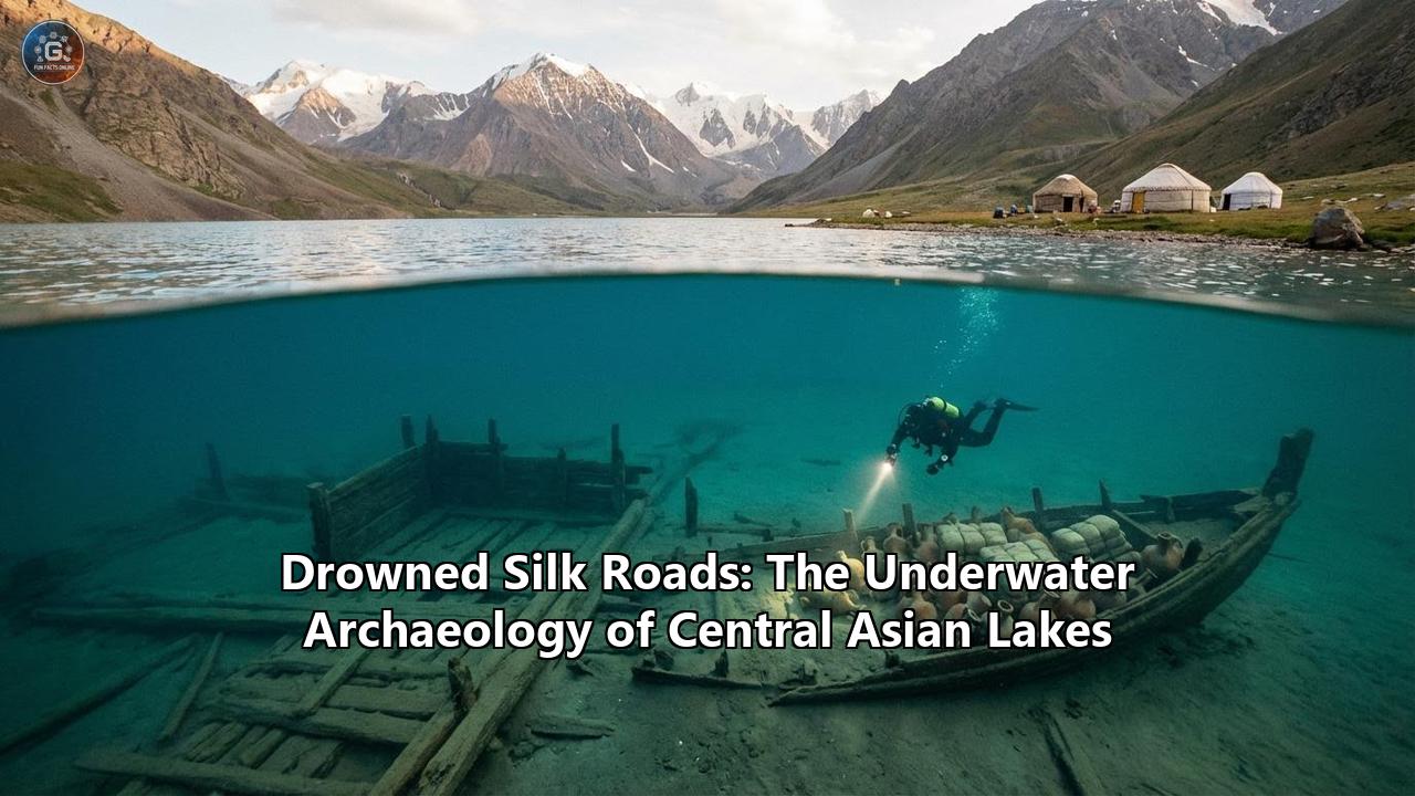
High in the western Tien Shan mountains of Kyrgyzstan, resting at an elevation of 1,600 meters (5,200 feet), lies Lake Issyk-Kul. Stretching 182 kilometers long and plunging to depths of over 700 meters, it is the second-largest high-altitude mountain lake in the world after Lake Titicaca. The lake’s name translates to "Hot Lake" in the Kyrgyz language, a nod to its mild salinity and immense thermal mass, which prevents it from ever freezing, even in the dead of the bitter Central Asian winter.
For centuries, Issyk-Kul was a vital oasis and stopover point for merchants traveling the northern routes of the Silk Road from the Far East to Europe. But beneath its azure, shimmering surface lies a sprawling graveyard of human history. Because Issyk-Kul is a "pulsating" lake, its water levels have fluctuated wildly, submerging successive layers of human habitation dating from the Bronze Age to the late Middle Ages.
Chigu: The Sunken Capital of the Wusun
The first whispers of Issyk-Kul’s underwater treasures emerged in the mid-19th century when the famed Russian explorer Pyotr Semyonov-Tyan-Shansky visited its shores. He watched local Kyrgyz nomads pull ancient, fired bricks from the lakebed to build their mausoleums, and he recorded local legends of a glittering city flooded by a golden well. Semyonov was searching for Chigu, the legendary capital of the ancient Wusun (Usun) nomadic empire. According to Chinese Han Dynasty chronicles from the 2nd century BC, Chigu—the "City of the Red Valley"—was a bustling metropolis where Chinese princesses were sent to marry Wusun rulers to secure military alliances against the Xiongnu.
Modern underwater excavations have proved the chronicles right. Divers in the shallow coastal zones have recovered astonishing artifacts from the Saka-Wusun period: 2,500-year-old bronze battleaxes, ceremonial cauldrons, self-sharpening daggers, and massive ceramic jars perfectly preserved in the silt. In 2015, divers from Tomsk State University discovered an entirely unknown Saka settlement at a depth of 23 meters, retrieving over 200 artifacts, including whetstones, bronze ritual sickles, and extensive evidence of sophisticated bronze-casting operations.
Toru-Aygyr and the Submerged Middle Ages
While the ancient Wusun ruins are spectacular, Issyk-Kul’s medieval sites provide the clearest picture of Silk Road urban life. Recently, an international team of archaeologists from the Russian Academy of Sciences and Kyrgyz institutions focused their efforts on the Toru-Aygyr complex on the lake's northwestern shore. Operating in shallow waters of 1 to 4 meters, the divers mapped a massive, complex medieval city that thrived under the Kara-Khanid Khanate, a powerful Turkic dynasty that ruled the region from the 10th to the 13th centuries.
What they found was staggering. The lakebed was littered with the remnants of baked-brick buildings, collapsed wooden beams, and massive stone millstones used for grinding grain. There were foundations of ornate public buildings—likely bathhouses, madrasas, or mosques, indicating a high level of urban planning and wealth. But the most profound discovery was a massive 60,000-square-meter underwater necropolis. Excavations of the burials revealed that the skeletons were laid out following strict Islamic traditions, with their faces turned toward Mecca.
Archaeologists believe that Toru-Aygyr was not abandoned gradually. At the beginning of the 15th century, a catastrophic earthquake struck the region. The tectonic violence caused the ground to slump and the lake waters to redistribute, swallowing the city whole in a sudden, Pompeii-like tragedy. The sudden inundation acted as an accidental time capsule, sealing the city's architecture and daily tools beneath the waves, safe from the erosion of wind and subsequent human development.
Fascinatingly, Toru-Aygyr also holds clues to one of history’s darkest chapters. Skeletons from 14th-century terrestrial cemeteries nearby have recently shown traces of the Yersinia pestis bacterium, suggesting that the shores of Lake Issyk-Kul might have been "ground zero" for the Black Death, which subsequently traveled via the Silk Road to wipe out more than half of Europe’s population. The ongoing forensic analysis of the newly recovered underwater skeletons may provide the missing links to understanding the origins of this global pandemic.
The Mystery of the Apostle Matthew
Adding an aura of mysticism to Issyk-Kul is the enduring legend of the Apostle Matthew. According to early Christian traditions and the Catalan Atlas—a world map created by Majorcan cartographer Abraham Cresques in 1375—a monastery of Armenian Christian brothers was located on the shores of Issyk-Kul. The map features an inscription in Old Latin translating to: "The place called Issyk-Kul. In this place is the monastery of the Armenian brothers, where, they say, is the body of St. Matthew, Apostle and Evangelist."
Historical records suggest that Nestorian Christians and Armenian monks, fleeing persecution in the Roman Empire and the Middle East, sought refuge along the tolerant, multicultural arteries of the Silk Road. For years, archaeologists scoured the shores for this monastery, finding nothing. It is now widely believed that the monastery, much like Toru-Aygyr and Chigu, was lost to the rising waters. Recent underwater discoveries of ceramic fragments bearing Armenian and Syriac stamps have further tantalized researchers, suggesting that the remains of one of the original Twelve Apostles may indeed rest in a sunken reliquary at the bottom of an alpine lake in Central Asia.
The Aral Sea: The Tragedy That Revealed a Lost World
If Lake Issyk-Kul represents a natural cycle of aquatic inundation, the Aral Sea represents a modern ecological disaster that inadvertently birthed a miraculous archaeological revelation. Located between Kazakhstan and Uzbekistan, the Aral Sea was once the fourth-largest lake in the world. However, beginning in the 1960s, Soviet agricultural policies diverted the massive Amu Darya and Syr Darya rivers to irrigate cotton fields in the desert. Stripped of its lifeblood, the Aral Sea rapidly evaporated, shrinking to a fraction of its former size and leaving behind a toxic, salt-crusted wasteland.
Yet, as the waters retreated, an astonishing secret was exposed. The drying of the sea revealed that the Aral had actually dried up before—naturally—and that humanity had thrived on its desiccated bed.
In 2001, local hunters and archaeologists walking across the newly dried seabed stumbled upon the ruins of massive stone structures. These were the settlements of Kerderi and Aral-Asar, dating back to the 11th to 14th centuries. During the medieval period, climatic shifts and the natural meandering of the Amu Darya river away from the Aral basin caused the sea to shrink drastically. Recognizing the opportunity, Silk Road settlers moved into the basin.
The ruins of Aral-Asar reveal a bustling Golden Horde-era city that existed for approximately 200 years. Far from being a mere nomadic camp, the settlement was a full-fledged economic entity. Archaeologists found evidence of extensive cereal agriculture (rice and wheat), sophisticated ceramic production, and massive brick kilns. The city functioned as a vital trade hub, connecting the nomadic steppes to the established urban centers of Khwarezm.
The most magnificent finds are the Kerderi mausoleums. Standing on stone foundations surrounded by vast necropolises, these monumental tombs were constructed of baked bricks and lined with brilliant glazed and unglazed decorative tiles featuring intricate floral and geometric patterns, and Arabic epigraphy. In one remarkable instance, archaeologists excavating beneath the floor of a mausoleum uncovered a large jug. Inside was a hidden hoard of heavily corroded iron tools—sickles, scythes, and knives—that were used to cultivate the land. In an era where iron tools were as valuable as gold, a local farmer had buried his livelihood in the sacred tomb, likely hoping to return.
He never did. In the late 16th century, the Amu Darya shifted its course once more, pouring billions of gallons of water back into the Aral basin. The residents fled, and the waters rose rapidly, swallowing Kerderi and Aral-Asar under 19 meters (62 feet) of water. The settlements lay in silent darkness for 400 years until modern human hubris drained the sea once more. Today, these sites stand as profound monuments to both the resilience of Silk Road civilizations in adapting to ecological extremes, and the terrifying rapidity with which environments can change.
The Caspian Sea: Sunken Fortresses and the Unknown Isthmus
To the west lies the Caspian Sea, the world’s largest inland body of water. Bounded by Russia, Iran, Azerbaijan, Turkmenistan, and Kazakhstan, the Caspian has historically been an impenetrable barrier—and a vital maritime highway—for Silk Road merchants. Like Issyk-Kul and the Aral Sea, the Caspian is infamous for its dramatic transgressive (rising) and regressive (falling) cycles. Over the past few millennia, its sea level has fluctuated by tens of meters, profoundly impacting the empires along its shores.
The Caspian Land Bridge
In recent years, geologists and historians have proposed a radical theory based on underwater bathymetry: between the 4th and 7th centuries AD, during a period of extreme sea-level regression, an actual land isthmus may have connected the Absheron Peninsula of modern-day Azerbaijan to the coast of Turkmenistan. If true, this "Caspian Route" would have provided a direct, dry-land shortcut for caravans traveling from China to the Caucasus and Europe, bypassing the treacherous southern route through Iran entirely. While tectonic shifts and returning waters eventually sank this natural bridge, the shallow shoals that remain point to a brief, golden era of expedited trans-Caspian trade.
Derbent: The Gates of the Sea
On the western shores of the Caspian, in the Russian republic of Dagestan, lies Derbent—one of the oldest continually inhabited cities in the world. For over 1,500 years, Derbent served as a critical choke point on the Silk Road. It is situated where the Caucasus Mountains come within a few kilometers of the sea, creating a narrow coastal corridor. To control this vital passage, successive Persian and Arab empires built the massive Naryn-Kala fortress.
But the fortifications did not stop at the beach. To prevent enemy ships and smugglers from bypassing the toll gates, the architects of Derbent built twin parallel stone walls that marched directly into the churning waters of the Caspian Sea, forming a highly secure, artificial harbor. Over the centuries, as sea levels rose and tectonic plates shifted, massive sections of these seawalls were drowned.
Today, underwater archaeologists diving in the coastal waters of Derbent trace the megalithic stone blocks of the 6th-century walls stretching hundreds of meters into the deep. The seabed here is a veritable museum of maritime Silk Road history. Divers have recovered massive stone anchors weighing up to 80 kilograms, equipped with bored holes for wooden stakes to increase their holding power. They have mapped shipwrecks, retrieved medieval Persian ceramics, and uncovered the drowned infrastructure of a port that once welcomed merchant vessels from Khorezm, India, and the Volga Bulgars.
Sabayil Castle: The Atlantis of Baku Bay
Perhaps the most visually captivating of all Central Asian underwater ruins is Sabayil Castle, located just 350 meters off the coast of Baku, Azerbaijan. Often referred to as the "Atlantis of the Caspian Sea," Sabayil is a testament to the intersection of magnificent architecture and merciless geology.
Built in 1232–1233 by the Shirvanshah dynasty, the fortress was constructed on a rocky island in Baku Bay. Measuring 180 meters long and 40 meters wide, it was an impregnable citadel featuring 15 semi-circular watchtowers and walls up to two meters thick. It served as a royal maritime palace, a defensive outpost against naval invasions, and a customs house for Silk Road trade. The fortress was so formidable that when the Mongol armies swept through the region in the 13th century, they were unable to capture it via naval assault and had to rely on terrestrial siege engines, only managing to damage its upper towers.
But what the Mongols could not destroy, the Earth did. In 1306, a catastrophic earthquake ruptured the Caspian basin. The seismic shock devastated Baku, collapsed the walls of Sabayil, and triggered a massive regional rise in the Caspian Sea level. The island and its mighty fortress sank completely beneath the waves, swallowed by the sea for over four centuries.
In 1723, a receding cycle of the Caspian Sea caused the ruined towers of Sabayil to eerily break the surface of the water once more. Beginning in the 1930s, Soviet marine archaeologists initiated an exhaustive 30-year underwater excavation of the site. What they brought to the surface was nothing short of breathtaking. Divers recovered over 700 massive stone tablets that had once formed a decorative frieze around the top of the castle walls. These stones were intricately carved with Farsi and Arabic calligraphy, reading "Bismillah" (In the name of Allah), and listing the genealogy of the Shirvanshah kings. Mixed among the text were astonishing high-relief carvings of mythical beasts, lions, bulls, and human faces—a rarity in Islamic art of the era.
Today, as the Caspian Sea once again experiences a cycle of receding water levels due to climate change, the foundations of the Sabayil Castle can occasionally be seen from the Baku Boulevard ferris wheel. It sits as a haunting reminder of the sea's power, while urban legends persist of hidden underwater tunnels connecting the sunken castle directly to the Maiden Tower in the heart of Baku's Old City.
The Science and Struggle of High-Altitude Subaquatic Archaeology
The recovery of these Drowned Silk Roads is not a simple task of donning a wetsuit and hopping off a boat. Underwater archaeology in Central Asia is fraught with immense logistical, physical, and technological challenges.
In places like Lake Issyk-Kul, altitude plays a major factor. Diving at 1,600 meters above sea level fundamentally alters the physiological mathematics of decompression. Nitrogen absorption in the bloodstream behaves differently than at sea level, requiring specialized tables and strict ascent protocols to avoid decompression sickness. Furthermore, while Issyk-Kul may be the "Hot Lake" that never freezes, temperatures at depths below 10 meters can be bone-chillingly cold, necessitating heavy drysuits.
Visibility is another massive hurdle. Centuries of silting, agricultural runoff, and the muddy bottoms of lakes like the Caspian and Aral mean that divers are often working in near-zero visibility. To combat this, modern expeditions rely heavily on cutting-edge technology. Remote Operated Vehicles (ROVs) equipped with multi-beam side-scan sonar are deployed to map the lakebeds before human divers ever enter the water. These sonar sweeps cut through the murk, revealing the geometric anomalies of straight walls, circular mounds, and unnatural elevations that indicate human structures.
Once targets are identified, specialized underwater hydraulic dredges and airlift pumps are used to carefully vacuum away centuries of sand and silt without damaging fragile ceramics, brittle wooden beams, or waterlogged human remains. Advanced photogrammetry is then utilized to stitch thousands of underwater photographs into high-resolution 3D digital models. This allows researchers back in dry laboratories in Bishkek, Baku, and Moscow to study the layout of a drowned city in its entirety—a vital necessity given that erosion and shifting currents are slowly grinding these ruins to dust.
A Mirror to the Future
The Drowned Silk Roads of Central Asian lakes offer far more than just a trove of antique curiosities. They force us to fundamentally reevaluate the narrative of human history in the region. The Silk Road was not a static highway; it was a living, breathing organism that adapted to the violent pulses of the Earth. When the lakes dried up, empires built cities in the fertile depressions. When the waters returned, those empires drowned, and the trade routes were redrawn across the new shorelines.
These submerged sites—the Wusun camps of Issyk-Kul, the Golden Horde kilns of the Aral Sea, and the regal stone walls of Sabayil in the Caspian—serve as the ultimate monuments to human adaptability. They show that our ancestors did not simply surrender to climate change; they migrated, rebuilt, and found new ways to connect the civilizations of the East and West.
Yet, there is a haunting warning embedded in the silt of these underwater ruins. As modern climate change accelerates, and human engineering continues to manipulate the waterways of Central Asia, the hydrological balance is shifting faster than ever before. The Aral Sea has already been sacrificed to the altar of agriculture, and the Caspian Sea is currently dropping at an alarming rate of several centimeters a year. As the waters recede, they may reveal more lost cities, but they also threaten the livelihoods of millions of modern people living along their coasts.
The underwater archaeology of Central Asian lakes is a testament to the fact that nothing—not the strongest stone fortress, nor the most pious temple, nor the wealthiest trading hub—is permanent. We build our empires on borrowed land, entirely at the mercy of the water. And as the submerged ghosts of the Silk Road quietly whisper from the deep, the water always reclaims what is hers.
Reference:
- https://www.azer.com/aiweb/categories/magazine/82_folder/82_articles/82_sabayil.html
- https://www.orexca.com/azerbaijan/baku/sabayil-castle.htm
- https://military-history.fandom.com/wiki/Sabayil_Castle
- https://en.archive.kabar.kg/news/issyk-kul-pearl-of-kyrgyzstan/
- https://www.today.az/news/interesting/227365.html
- https://geoexplorersclub.com/en/podvodnye-tajny-i-neraskrytye-zagadki-issyk-kulya/
- https://open.kg/en/about-kyrgyzstan/nature/water-resources/lake/secrets-of-issyk-kul-lake/35104-chigu-mekka-issledovateley-priissykkulya.html
- https://www.ancient-origins.net/news-history-archaeology/one-more-ancient-civilization-found-lake-issyk-kul-could-be-where-st-020512
- https://aber.apacsci.com/index.php/st/article/view/2801
- http://www.oceantreasures.org/blog/underwater-archeology/one-more-ancient-civilisation-found-in-lake-issyk-kul.html
- https://allinnet.info/world/armenian-monastery-on-issyk-kul/
- https://divers24.com/kyrgyzstan-extremely-interesting-find-from-ancient-times-in-lake-issyk-kul/
- https://en.wikipedia.org/wiki/Sabayil_Castle
- https://sg.trip.com/moments/theme/destination-jety-oguz-1912020-guides-993135/
- https://vestnik.krsu.kg/en/archive/45/1058
- https://irs-az.com/new/files/2016/186/2393.pdf
- https://aperture.org/editorial/chloe-dewe-mathews-bruggen/
- https://en.unesco.org/silkroad/content/derbent
- https://caucasushistory.ru/2618-6772/article/view/17365