Yosemite Valley's formation is a complex story involving ancient volcanic activity, the slow cooling of subterranean magma, the uplift of the Sierra Nevada, and the carving power of rivers and glaciers. Recent research continues to refine our understanding of this iconic landscape.
Early Geological Processes and Volcanism:The oldest rocks in Yosemite originated from sediments and submarine volcanic material deposited in shallow water near the continent during the Paleozoic period. Tectonic forces later transported these materials eastward. Over time, much of this rock was metamorphosed, uplifted, and eroded.
Between approximately 220 million and 80 million years ago, the subduction of an ancestral Pacific plate beneath the North American Plate led to the formation of the Sierra Nevada Batholith. This process involved multiple pulses of magma. Some magma cooled slowly deep underground, creating the vast granitic plutons that form the core of Yosemite. Other magma reached the surface, erupting as a chain of volcanoes. These volcanic mountains were later intruded by more magma and underwent metamorphosis. While these ancient volcanoes have largely eroded away, their activity played a crucial role in forming the granitic bedrock that defines Yosemite.
Volcanic activity resurfaced in the region between 20 and 5 million years ago, primarily north of the current park boundaries. These volcanoes produced large mudflows and lava that buried ancient river canyons. Evidence of this later volcanism can still be seen in areas like Little Devils Postpile, a formation of columnar basalt near Tuolumne Meadows, indicating the rapid cooling of thick lava. The eastern side of Yosemite, bordering the Long Valley and Mono Lake areas, has experienced continuous volcanic activity for the last 5 million years, with the notable formation of the Long Valley Caldera around 700,000 years ago. However, there are no active volcanoes within Yosemite National Park itself today. Remnants of older metamorphic and younger volcanic rocks make up a small percentage of the park's landscape.
The Carving of the Canyon - A Story of Rivers, Uplift, and a "Ghost Volcano":For many years, the prevailing theory for Yosemite Valley's impressive depth centered on the uplift of the Sierra Nevada mountains over the last 10 million years. This uplift steepened the slopes, causing rivers like the Merced River to flow faster and cut more deeply into the granite.
However, provocative new research published in April 2025 in the journal Geosphere suggests an alternative, or perhaps complementary, factor. This hypothesis proposes that a now-vanished volcano and a "lost river" draining its slopes played a significant role in carving the valley's depths, particularly within the last 10 million years. According to this study, approximately 5 to 10 million years ago, a chain of volcanoes buried the northern Sierra Nevada in massive mudflows, creating a volcanic plain. While these deposits are visible north of Yosemite, they are absent around the Merced River. The researchers suggest that volcanic rocks transported by the Merced River must have originated from this volcanic chain. A large, now-gone river draining these volcanic peaks would have significantly increased the flow of the ancestral Merced River and Tenaya Creek, providing them with the erosive power to carve the deep canyons of Yosemite Valley and Tenaya Canyon.
Further research published in late 2022 in the Geological Society of America Bulletin, utilizing a technique called helium-4/helium-3 thermochronometry, provided new insights into the timing of the canyon's formation. This study suggests that much of Yosemite Valley's current depth was carved relatively recently, within the last 5 to 10 million years, a much younger timeframe than some previous estimates that went as far back as 50 million years. The researchers concluded that after a long period of relative stability, the topography of the Yosemite region was transformed by significant canyon incision in the late Cenozoic era. This deepening likely occurred through a combination of fluvial (river) and later glacial erosion. They propose that an initial shallow valley was carved by rivers, and then subsequent mountain uplift around 5 million years ago steepened the Merced River, causing it to cut the canyon deeper.
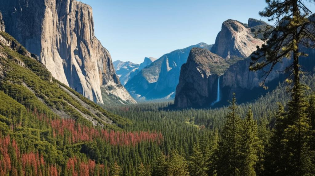
The Glacial Touch:It is widely agreed that glaciers played a significant role in shaping Yosemite Valley, particularly in the last 2 to 3 million years. As the climate cooled during the Ice Ages, massive glaciers advanced through the existing river-carved valley. These glaciers further deepened and widened the canyon, sculpting its steep walls and giving it the characteristic U-shape seen today. Iconic features like Lyell Canyon are also prime examples of U-shaped glacial valleys. While glaciers put the finishing touches on the valley, they are believed to have filled a pre-existing deep canyon.
Ongoing Research and Understanding:The geological history of Yosemite Valley is a subject of ongoing research and debate. Scientists continue to use new techniques and analyze data to refine the timeline and understand the interplay of volcanic activity, tectonic uplift, river erosion, and glaciation that created this spectacular landscape. While the general processes are understood, the precise timing and relative contributions of each continue to be areas of active scientific inquiry. The iconic granite domes and walls, such as El Capitan and Half Dome, stand as testaments to these powerful geological forces acting over millions of years.