In the dense, emerald embrace of the Campeche jungle, where the humid air hangs heavy and the roar of howler monkeys echoes through the canopy, a secret has lain hidden for over a millennium. For centuries, locals have farmed the edges of this verdant wilderness, and in modern times, cars have sped along the region’s only highway, their drivers oblivious to the ghosts of a metropolis sleeping just minutes away. It was a place of monumental pyramids, bustling plazas, and engineered waterways—a city that once teemed with up to 50,000 souls.
Its name is Valeriana.
Its discovery in October 2024 did not come from a machete-wielding expedition or a dusty map found in a colonial archive. It did not come from a funded excavation by a prestigious museum. Instead, one of the most significant archaeological finds of the 21st century was made by a doctoral student sitting at a computer, scrolling through the forgotten pages of a Google search.
This is the story of Valeriana, the lost megalopolis that is rewriting the history of the Maya civilization, and the technological revolution that allowed us to see the invisible.
Part I: The Anomaly on Page 16
The history of archaeology is often romanticized as a discipline of physical endurance—digging in the dirt, brushing away sand, and battling the elements. But the discovery of Valeriana began in the digital realm. Luke Auld-Thomas, a PhD student at Tulane University, was grappling with a problem common to modern science: funding.
Lidar (Light Detection and Ranging) technology has revolutionized archaeology in the last decade. By firing billions of laser pulses from an aircraft to the ground, researchers can penetrate the dense jungle canopy to create a 3D map of the earth beneath. It strips away the trees digitally, revealing the stone bones of ancient civilizations. However, Lidar missions are prohibitively expensive. Auld-Thomas wanted to study the Maya landscape, but he didn't have the budget to charter a plane.
Driven by a hunch, he turned to the internet. He reasoned that perhaps other scientific disciplines—ecology, forestry, or climate science—had already mapped the area for different purposes. He began trawling through search results for Lidar datasets in Mexico.
Most people stop looking after the first page of Google results. Auld-Thomas kept going. On what he recalls was roughly the 16th page of search results—a digital no-man's-land—he found a link to a forgotten study from 2013. A consortium led by The Nature Conservancy had commissioned a Lidar survey of the Campeche forests. Their goal was environmental monitoring: measuring the biomass of the forest to calculate carbon emissions and prevent deforestation.
To the environmental scientists, the data was a measure of trees. To an archaeologist's eye, it was a treasure map. When Auld-Thomas downloaded the dataset and processed it with archaeological algorithms—stripping away the vegetation that the ecologists were studying—he didn't see a flat forest floor.
He saw a city.
Part II: The Ghost City of Campeche
The scale of what appeared on Auld-Thomas’s screen was staggering. This was not a small rural outpost or a minor ceremonial center. It was a sprawling urban complex, a "megalopolis" that had been hiding in plain sight.
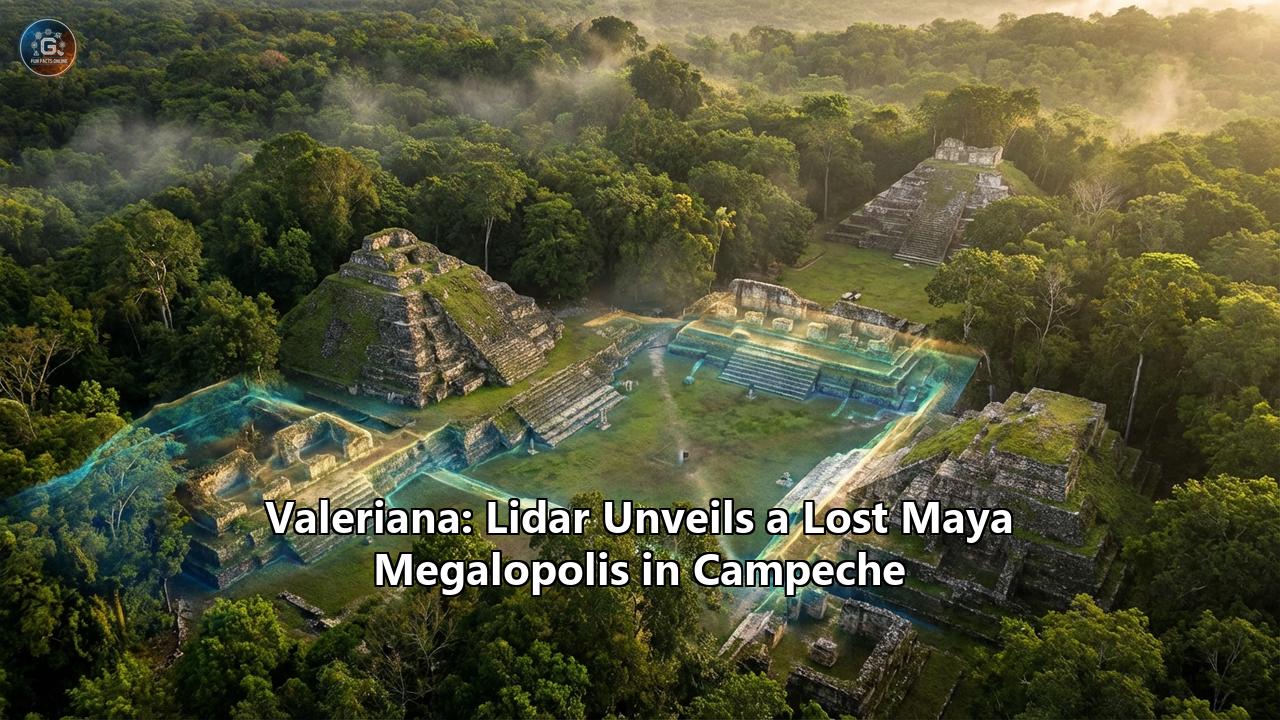
The city, which the team named Valeriana after a nearby freshwater lagoon, is located in the southeastern region of Campeche, Mexico. It covers approximately 16.6 square kilometers (6.4 square miles). But the raw numbers barely do justice to the complexity of the site.
The Lidar scan revealed a cityscape defined by two "monumental precincts"—massive downtown cores featuring the hallmarks of a Classic Maya political capital. These two hubs are situated about two kilometers apart but are linked by a continuous web of human settlement. connecting them is a broad, elevated causeway, known as a sacbe (plural sacbeob), or "white road," which would have once been paved with gleaming white plaster, a superhighway for ancient processions and commerce.
Within these precincts, the team identified:
- Temple Pyramids: Massive stone structures rising up to 15 meters (50 feet) into the air, likely used for religious rituals and royal burials.
- Enclosed Plazas: Large public squares flanked by administrative buildings where markets were held and the public gathered.
- A Ballcourt: The iconic playing field of the Mesoamerican ballgame, a ritual sport with cosmic significance involving a rubber ball and stone hoops.
- A Reservoir: A massive engineering feat formed by damming a natural arroyo (seasonal watercourse) to store water for the dry season.
- An E-Group Assemblage: A specific architectural alignment used for astronomical observation, marking the solstices and equinoxes. This feature suggests the city’s roots go back to the Preclassic period, perhaps before 150 AD.
Surrounding these monumental cores was a dense sprawl of residential suburbs. The scan identified 6,764 individual structures in the survey area. This creates an aggregate settlement density of 55.3 structures per square kilometer. To put that in perspective, Valeriana is the second-densest Maya city ever discovered, surpassed only by the mighty Calakmul, which lies about 100 kilometers away near the Guatemalan border.
Part III: The "Empty" Spaces Legend
For over a century, the prevailing model of Maya civilization was one of "city-states" separated by vast, empty stretches of wilderness. We knew of the great capitals like Tikal, Chichen Itza, and Palenque. We assumed that between these islands of urbanization lay a sea of sparsely populated jungle.
Valeriana shatters this myth.
The discovery proves that the "empty" spaces on our maps are not empty; they are simply unexplored. Valeriana sits in a region of Campeche that was considered a blind spot—a "terra incognita" between known sites. The fact that a city of this magnitude could exist there implies that the Maya Lowlands were not a collection of isolated cities, but a continuous, interconnected tapestry of towns, villages, and megalopolises.
"We ran out of empty space," the researchers noted in their study published in the journal Antiquity. The landscape was entirely engineered. Everywhere they looked in the Lidar data, they found evidence of human hands: agricultural terraces carved into hillsides, drainage canals, house mounds, and roads.
This suggests that the population of the Maya civilization was significantly higher than previously estimated. If a random slice of "empty" jungle contains a city of 50,000 people, the total population of the Maya world during the Classic period (250–900 AD) could have numbered in the millions—far more than the region supports today.
Part IV: Life in the Megalopolis
What would life have been like in Valeriana at its peak, around 750–850 AD?
Imagine standing on the central causeway at dawn. To your left and right, the jungle has been pushed back. The landscape is a mosaic of white plaster and green agriculture. The air smells of woodsmoke from thousands of cooking fires where families are preparing maize tortillas.
The city is noisy. With a population density comparable to modern semi-urban environments, you would hear the sounds of construction, the barking of dogs, the gobble of turkeys, and the hum of a busy market. The elite—the rulers and priests—reside in the stone palaces atop the acropolises, draped in jade and quetzal feathers. But the real story of Valeriana is the common people.
The Lidar reveals an extensive network of housing platforms. These were not simple huts; they were the foundations of a complex society. The residents of Valeriana were master engineers of their environment. They didn't just live in the jungle; they terraformed it.
- Water Management: In a region with a pronounced dry season and no surface rivers, water was power. The dammed arroyo and various reservoirs show that the city had a centralized utility system to capture and store rainwater.
- Agriculture: The hillsides were likely terraced to prevent erosion and maximize planting space for maize, beans, and squash. This "garden city" model allowed them to feed a massive population without modern machinery.
However, this density also hints at the city's eventual doom.
Part V: The Trap of Success
The architecture and pottery styles (inferred from nearby sites) suggest Valeriana flourished during the Classic period and reached its apogee just before the great Maya Collapse of the 9th century.
The Lidar data paints a picture of a civilization that had "maxed out" its environment. Every inch of arable land was cultivated. Every drop of water was managed. There was no slack in the system. When the climate shifted—as paleoclimate data confirms it did, bringing severe, century-long droughts—a city like Valeriana would have been incredibly vulnerable.
With 50,000 mouths to feed and reservoirs running dry, the social contract between the rulers (who claimed to control the rain) and the people would have fractured. The density that made Valeriana a powerhouse became its trap. The city was likely abandoned rapidly, the jungle reclaiming the plazas and pyramids, hiding them until a laser beam pierced the canopy 1,200 years later.
Part VI: The New Age of Digital Archaeology
The discovery of Valeriana is a watershed moment for archaeology, not just for what was found, but how. It represents the democratization of exploration.
Traditionally, discovery was the privilege of those with massive grants. Now, vast amounts of data—from environmental surveys, satellite imagery, and open-source science projects—are sitting on servers, waiting for curious minds to analyze them.
"The government never knew about it; the scientific community never knew about it," Auld-Thomas said. This highlights a startling reality: we have mapped the surface of the Moon and Mars in greater detail than we have mapped the history of our own planet's tropical civilizations.
But it also poses a new dilemma. We are finding sites faster than we can ever hope to study them.
Excavating a single Maya building can take years of meticulous labor. Valeriana has nearly 7,000 structures. To excavate it fully would take centuries and billions of dollars. And Valeriana is just one site in one small survey block. If we were to scan the entire Maya Lowlands, we would likely find tens of thousands of unknown settlements.
This forces a shift in the discipline. Archaeology is moving from a science of "digging" to a science of "data conservation." We may never clear the trees from Valeriana. It may remain a "digital city," explored primarily through screens and 3D models. The physical ruins will stay protected by the forest, safe from looting and tourism, while researchers study its layout to understand urban planning, sustainability, and resilience.
Part VII: Why It Matters
Why should we care about a lost city in Mexico?
Valeriana offers a mirror to our own world. It shows us that the tropics were not a barrier to civilization, but a cradle for it. It demonstrates that ancient peoples were capable of urbanization and environmental engineering on a scale that rivals modern efforts.
Moreover, it serves as a warning. Valeriana was a complex, highly specialized society that thrived for centuries—until it didn't. Its silence today is a testament to the fragility of complex systems in the face of environmental change.
As we face our own climate crisis and debates about urban density, the "lost" Maya are not so distant. They were people who built, loved, innovated, and struggled, just like us. And thanks to a curious student and a few pulses of light, their voices have been added back to the chorus of human history.
The jungle has given up one of its greatest secrets. Valeriana is back on the map, a testament to the enduring mystery of the past and the limitless potential of the future of discovery.
Reference:
- https://bigthink.com/strange-maps/lidar-finds-valeriana/
- https://english.elpais.com/culture/2024-10-30/valeriana-the-ancient-mayan-city-found-thanks-to-laser-imaging.html
- https://learningenglish.voanews.com/a/researchers-discover-large-ancient-mayan-city-/7847828.html
- https://www.youtube.com/watch?v=1retPXDYjxs
- https://en.wikipedia.org/wiki/Valeriana_(archaeological_site))
- https://www.cambridge.org/core/journals/antiquity/article/running-out-of-empty-space-environmental-lidar-and-the-crowded-ancient-landscape-of-campeche-mexico/FFDB435047017853F26CFC5D8804B08D
- https://in-cyprus.philenews.com/popular-on-web/student-accidentally-discovers-lost-mayan-city-in-mexican-jungle/
- https://laikai.lt/e/valeriana-mayan-megacity-revealed-by-lidar
- https://www.sci.news/archaeology/maya-city-valeriana-13406.html
- https://timesofindia.indiatimes.com/world/rest-of-world/lost-mayan-city-of-valeriana-discovered-hidden-deep-in-mexico-forests/articleshow/114774822.cms
- https://www.newindianexpress.com/xplore/2024/Oct/31/valeriana-the-lost-mayan-city-that-was-accidentally-discovered-in-mexico-2
- https://www.chichenitza.com/blog/valeriana-the-new-mayan-city-discovered-in-campeche
- https://www.smithsonianmag.com/smart-news/found-dataset-reveals-lost-maya-city-hiding-in-plain-sight-beneath-a-mexican-forest-180985354/
- https://hyperallergic.com/ancient-maya-city-discovered-in-southeastern-mexico/
- https://www.cbsnews.com/news/valeriana-maya-city-discovered-mexico-campeche-jungle/
- https://www.youtube.com/shorts/0Fv-pKis0Hk